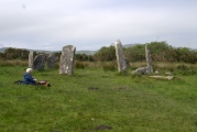
<< Our Photo Pages >> Derreenataggart - Stone Circle in Ireland (Republic of) in Co. Cork

Submitted by Anthony_Weir on Sunday, 13 October 2002  Page Views: 16699

Neolithic and Bronze AgeSite Name: Derreenataggart Alternative Name: Derrintaggart, Doirín an tSagairt Thiar
Country: Ireland (Republic of) County: Co. Cork Type: Stone Circle
Nearest Town: Castletownbere  Nearest Village: Derreenataggart
Map Ref: V6655646295
Discovery Map Number: D84
Latitude: 51.653852N  Longitude: 9.928941W
Condition:
5Perfect
4Almost Perfect
3Reasonable but with some damage
2Ruined but still recognisable as an ancient site
1Pretty much destroyed, possibly visible as crop marks
0No data.
-1Completely destroyed
4 Ambience:
5Superb
4Good
3Ordinary
2Not Good
1Awful
0No data.
5 Access:
5Can be driven to, probably with disabled access
4Short walk on a footpath
3Requiring a bit more of a walk
2A long walk
1In the middle of nowhere, a nightmare to find
0No data.
5 Accuracy:
5co-ordinates taken by GPS or official recorded co-ordinates
4co-ordinates scaled from a detailed map
3co-ordinates scaled from a bad map
2co-ordinates of the nearest village
1co-ordinates of the nearest town
0no data
5

Internal Links:
External Links:

I have visited· I would like to visit

43559959 CrystalSkullLady rrmoser would like to visit

optimistic20814 visited on 15th Aug 2018 - their rating: Cond: 3 Amb: 4 Access: 4 On the day I visited, I could see Ardnakinna light house on Bere Island between the two south facing stones.

mike53 visited on 1st May 2010 - their rating: Cond: 3 Amb: 4 Access: 4

SteveC visited on 4th May 2006 - their rating: Cond: 4 Amb: 5 Access: 5

Klingon visited on 28th Mar 2005 - their rating: Cond: 3 Amb: 5 Access: 5

MAIGO AngieLake have visited here

Average ratings for this site from all visit loggers: Condition: 3.25 Ambience: 4.5 Access: 4.5

Derreenataggart
Derreenataggart submitted by ladrin : Beautiful setting... (Vote or comment on this photo)
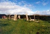
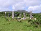
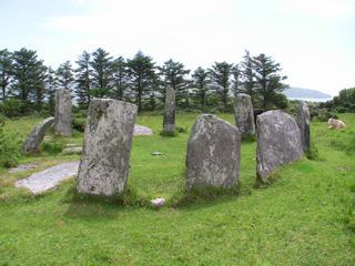
Eight of the post-like stones of this neat circle are standing, including one of the radially-set portal stones. The other portal stone has broken, and 3 other stones of the circle have fallen. The axial stone is a fine long slab 1.2 m high and 2.1 m long.

~See Ardgroom Outward for another circle of post- like stones.

~Just over 6.4km (4ml) N by W is the tall Ogham-inscribed standing stone at Faunkill-and-the-Woods.

~Just over 8 km (5 ml) E by S, in Ardaragh on Bear (or Bere) Island (linked to the mainland by road) is a wedge-tomb V 75 44) close to a lane from the former British naval rifle range to Rerrin hamlet. It comprises a collapsed main chamber about 5m long, the front (W) end of which is a short portico or antechamber with a septal stone 130cm high.

Access: 1.2km ( ¾ ml) WNW of Castletown Berehaven and 50m N of a byroad leading N off the L 61.
You may be viewing yesterday's version of this page. To see the most up to date information please register for a free account.

Derreenataggart
Derreenataggart submitted by bburdetteva : Easily accessible with some (friendly) cow dodging. (1 comment - Vote or comment on this photo)

Derreenataggart
Derreenataggart submitted by chaika : Taken 9/22/14, this shows the sun setting behind the axial on the Autumn Equinox. (Vote or comment on this photo)

Derreenataggart
Derreenataggart submitted by ladrin : Distinctive recumbent or axial stone (1 comment - Vote or comment on this photo)

Derreenataggart
Derreenataggart submitted by Aska : The view from the east. (1 comment - Vote or comment on this photo)

Derreenataggart
Derreenataggart submitted by AngieLake : Here's another view of the circle near Castletownbere, on the Beara Peninsula in West Cork. The spelling on the brown pointer notice board at the site was 'Derrintaggart West', but in the Discovery Map series it is referred to as Derreenataggart. It is a beautiful site that I hope to return to one day: one of the hundreds of megalithic sites that litter the Beara Peninsula. (2 comments)

Derreenataggart
Derreenataggart submitted by Flickr : Dereenataggart stone circle, County Cork Image copyright: Erik's pictures, hosted on Flickr and displayed under the terms of their API.

Derreenataggart
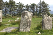
Derreenataggart submitted by ladrin : Stones are tall slabs, what is typical for the south-west region.

Derreenataggart
Derreenataggart submitted by AngieLake : This image found recently on disk of film photos taken in 2001 or 2002. To join rather than replace the small but more colourful original on site page, hopefully?

Derreenataggart
Derreenataggart submitted by AngieLake : Taken in 2001 or 2002 - this image just found and downloaded off disk processed at the time. Sorry about quality.

Derreenataggart
Derreenataggart submitted by MAIGO : This stone circle is located near Casteltownbere and easy to find.

Derreenataggart
Derreenataggart submitted by bburdetteva : Picturesque location!

Derreenataggart
Derreenataggart submitted by Johnny : Derreenataggart Stone Circle, Co. Cork (V665 463): Derreenataggart is both easily accessible and a fine example of an axial or recumbent stone circle. It is now incomplete: of an original fifteen or so stones, nine remain erect and three are now prostrate. The stones are graded in height increasing from the stones adjacent to the recumbent, c0.4m in height, up to the stones in the portal are...

Derreenataggart
Derreenataggart submitted by mike53 : A page from our photo album showing several views of the Derreenataggart stone circle.

Derreenataggart
Derreenataggart submitted by Energyman : The two stones in the center of the picture are aligned to the equinox sunset.

Derreenataggart
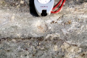
Derreenataggart submitted by Energyman : One of the possible cupmarks, marked by the compass

Derreenataggart
Derreenataggart submitted by Energyman : The flat, grooved stone with pointed end directed at the notch, 197 azimuth, +1 degree elevation

Derreenataggart
Derreenataggart submitted by Energyman : From the SW 25/5/17. A lovely, peaceful circle easy to reach.

Derreenataggart
Derreenataggart submitted by Energyman : This is the stone that lies flat, level with the earth surface. It has an obvious man-made groove running down its entire surface, with cup marks (to my mind.) It is 2003 by 380mm, and aligns itself exactly between the two entrance stones at 192 degrees True, which points to a notch on the horizon.

Derreenataggart
Derreenataggart submitted by ladrin : The site is well signposted.

Derreenataggart
Derreenataggart submitted by AngieLake : Taller stones at beautiful Derreenataggart, taken in 2001[?]

Do not use the above information on other web sites or publications without permission of the contributor.
Click here to see more info for this site

Nearby sites

Click here to view sites on an interactive map of the area

Key: Red: member's photo, Blue: 3rd party photo, Yellow: other image, Green: no photo - please go there and take one, Grey: site destroyed

Download sites to:
KML (Google Earth)
GPX (GPS waypoints)
CSV (Garmin/Navman)
CSV (Excel)

To unlock full downloads you need to sign up as a Contributory Member. Otherwise downloads are limited to 50 sites.

STILE by Clive Ruggles


Turn off the page maps and other distractions

Nearby sites listing. In the following links * = Image available
 187m W 277° Doirín an tSagairt Thiar stone pair* Standing Stones
 194m NE 46° Knockaneroe standing stone pair* Standing Stones
 912m ESE 123° Chaisleain Bhearra Standing Stone* Standing Stone (Menhir) (V6731345782)
 1.6km ENE 72° Foildarrig Stone Row / Alignment
 2.0km SW 224° Fanahy* Stone Row / Alignment (V6512144870)
 2.3km W 262° Teernahillane Ringfort* Stone Fort or Dun (V6428346023)
 2.5km WSW 258° Teernahillane Standing Stones Standing Stones (V64124585)
 2.6km E 82° Doire Mheithean Thiar boulder burials* Burial Chamber or Dolmen
 2.7km SW 228° Clongaskan* Stone Row / Alignment (V64504452)
 2.7km NE 52° Cluain Troim standing stone* Standing Stone (Menhir)
 2.8km W 269° Ternahillane West* Wedge Tomb (V6379246327)
 3.0km N 5° Crumpane Boulder Burials* Burial Chamber or Dolmen
 3.0km E 92° Derrymihan W row Stone Row / Alignment (V696461)
 3.1km ENE 65° Derrymihin West wedge tomb* Wedge Tomb
 3.2km ENE 64° Derrymeehin West standing stone* Standing Stone (Menhir)
 3.4km NNW 348° Crumpane Standing Stones Standing Stones (V65934959)
 3.4km NNE 24° Kilmackowen Wedge Tomb* Wedge Tomb (V6805249356)
 3.5km NNE 23° Kilmackowen Standing Stone* Standing Stone (Menhir) (V67994948)
 3.7km WSW 244° Knockoura* Stone Row / Alignment (V6318444771)
 3.8km NE 44° Cloontreem Wedge Tomb* Wedge Tomb
 4.1km WSW 238° Gour Standing Stone* Standing Stone (Menhir) (V6306544208)
 4.2km NNE 17° Gowlane* Standing Stone (Menhir) (V67905031)
 4.5km NW 310° Coulagh * Stone Circle (V63184925)
 4.5km NNW 329° Eyeries Stone Row / Alignment (V64335022)
 4.7km N 9° Caheravart* Ancient Village or Settlement (V67405096)
View more nearby sites and additional images

<< Coom Wedge Tomb

Derrynablaha >>

Please add your thoughts on this site

Clickable Map of Ireland

Earthen Long Barrows, Field

Earthen Long Barrows, Field

Archived Web links for Derreenataggart

STILE by Clive Ruggles

Sponsors

Auto-Translation (Google)

Translate from English into:

"Derreenataggart" | Login/Create an Account | 2 News and Comments
  
Go back to top of page    Comments are owned by the poster. We aren't responsible for their content.
Re: Derreenataggart by Andy B on Monday, 07 May 2018
(User Info | Send a Message)
Class Stone circle - multiple-stone
Townland DERREENATAGGART WEST
SMR No. CO115-011002-
Description On level patch of rough pasture on SE slopes of Miskish mountain. Circle incomplete; may have consisted of fifteen stones. Twelve survive, three of these prostrate. Orthostats are 0.4m to 2.4m L, 0.15m to 0.3m T and 1.25m to 1.9m H. Internal measurement along mains axis, aligned E-W, is 7.8m. (Ó Nualláin 1984, 20, no. 26) The above description is derived from the published 'Archaeological Inventory of County Cork. Volume 1: West Cork' (Dublin: Stationery Office, 1992). In certain instances the entries have been revised and updated in the light of recent research. Date of upload/revision: 14 January 2009

Source: NMS Ireland
[ Reply to This ]

Re: Derreenataggart by AngieLake on Sunday, 21 December 2008
(User Info | Send a Message)
"Top Rated Stone Circles in The Republic of Ireland...according to http://www.megalithic.co.uk, whose researchers rank each site for overall condition, ambience and ease of access. Scoring is out of 15, with only the sites that achieve 10 points or more listed.

Derreenataggart, Co. Cork, 14
Kilmartin Lower, Co. Cork, 14
Glanbrack, Co. Cork, 13
Ardgroom, Co. Cork, 12
...."
.... and so on (27 altogether).

The list comes from a little A5 sized hard-backed book called 'The Stonehenge Companion' which I picked up for only £2.99 at Stonehenge visitor centre's shop last Wednesday. It is published by English Heritage in their Think Books series, author James McClintock. It's a miscellany of interesting facts relating to Stonehenge, even to the names of rock (and other types of music?) albums including the name.
It was marked £9.99 on the cover, but may be reduced because it is a 2006 publication. I've only dipped into it briefly so far, but it looks very promising!
[ Reply to This ]

Your Name: Anonymous [ Register Now ]
Subject:


Add your comment or contribution to this page. Spam or offensive posts are deleted immediately, don't even bother

<<< What is five plus one as a number? (Please type the answer to this question in the little box on the left)
You can also embed videos and other things. For Youtube please copy and paste the 'embed code'.
For Google Street View please include Street View in the text.
Create a web link like this: <a href="https://www.megalithic.co.uk">This is a link</a>  

Allowed HTML is:
<p> <b> <i> <a> <img> <em> <br> <strong> <blockquote> <tt> <li> <ol> <ul> <object> <param> <embed> <iframe>

We would like to know more about this location. Please feel free to add a brief description and any relevant information in your own language.
Wir möchten mehr über diese Stätte erfahren. Bitte zögern Sie nicht, eine kurze Beschreibung und relevante Informationen in Deutsch hinzuzufügen.
Nous aimerions en savoir encore un peu sur les lieux. S'il vous plaît n'hesitez pas à ajouter une courte description et tous les renseignements pertinents dans votre propre langue.
Quisieramos informarnos un poco más de las lugares. No dude en añadir una breve descripción y otros datos relevantes en su propio idioma.