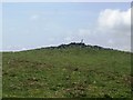
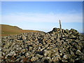
<< Our Photo Pages >> Corndon Hill 5 - Cairn in Wales in Powys
Submitted by TimPrevett on Wednesday, 29 December 2004 Page Views: 4314
Neolithic and Bronze AgeSite Name: Corndon Hill 5Country: Wales County: Powys Type: Cairn
Nearest Town: Bishops Castle Nearest Village: White Grit
Map Ref: SO30869632
Latitude: 52.560303N Longitude: 3.021328W
Condition:
| 5 | Perfect |
| 4 | Almost Perfect |
| 3 | Reasonable but with some damage |
| 2 | Ruined but still recognisable as an ancient site |
| 1 | Pretty much destroyed, possibly visible as crop marks |
| 0 | No data. |
| -1 | Completely destroyed |
| 5 | Superb |
| 4 | Good |
| 3 | Ordinary |
| 2 | Not Good |
| 1 | Awful |
| 0 | No data. |
| 5 | Can be driven to, probably with disabled access |
| 4 | Short walk on a footpath |
| 3 | Requiring a bit more of a walk |
| 2 | A long walk |
| 1 | In the middle of nowhere, a nightmare to find |
| 0 | No data. |
| 5 | co-ordinates taken by GPS or official recorded co-ordinates |
| 4 | co-ordinates scaled from a detailed map |
| 3 | co-ordinates scaled from a bad map |
| 2 | co-ordinates of the nearest village |
| 1 | co-ordinates of the nearest town |
| 0 | no data |
Internal Links:
External Links:
I have visited· I would like to visit
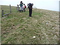
w650marion visited on 7th Mar 2022 - their rating: Cond: 2 Amb: 4 Access: 2 Sixth big cairn in the Corndon Hill walk. Again with several shelters dug into it. A really cold harsh wind blowing but we’re carrying on to the last cairn.
TimPrevett have visited here
")
More details to follow.
You may be viewing yesterday's version of this page. To see the most up to date information please register for a free account.
")
Do not use the above information on other web sites or publications without permission of the contributor.
Nearby Images from Geograph Britain and Ireland:
©2011(licence)
©2009(licence)
©2011(licence)
©2011(licence)
©2011(licence)
The above images may not be of the site on this page, they are loaded from Geograph.
Please Submit an Image of this site or go out and take one for us!
Click here to see more info for this site
Nearby sites
Key: Red: member's photo, Blue: 3rd party photo, Yellow: other image, Green: no photo - please go there and take one, Grey: site destroyed
Download sites to:
KML (Google Earth)
GPX (GPS waypoints)
CSV (Garmin/Navman)
CSV (Excel)
To unlock full downloads you need to sign up as a Contributory Member. Otherwise downloads are limited to 50 sites.
Turn off the page maps and other distractions
Nearby sites listing. In the following links * = Image available
407m SW 233° Corndon Hill 6* Cairn (SO30539608)
442m N 4° Corndon Hill 3* Cairn (SO30909676)
486m N 9° Corndon Hill 4* Cairn (SO30949680)
539m NW 308° Corndon Hill 1* Cairn (SO30449666)
596m NW 309° Corndon Hill 8* Cairn (SO304967)
663m NNW 336° Corndon Hill 2* Cairn (SO30609693)
897m WNW 302° Corndon Hill 7* Cairn (SO301968)
1.3km NNW 339° The Whetstones* Stone Circle (SO30429753)
1.3km NW 318° New House Long Barrow* Long Barrow (SO300973)
1.4km SSW 194° Cwm Mawr Stone Axe Factory Ancient Mine, Quarry or other Industry (SO305950)
1.8km NNW 348° Druid's Castle* Stone Circle (SO305981)
2.0km SW 227° Roundton* Hillfort (SO29389498)
2.0km NNW 347° Mitchell's Fold outlier* Standing Stone (Menhir) (SO30429828)
2.1km NNW 347° Mitchell's Fold* Stone Circle (SO30429837)
2.5km NNW 344° Middleton Hill Round Barrow(s) (SO302987)
2.5km N 7° Stapeley Hill Earthworks* Misc. Earthwork (SO312988)
2.6km N 0° Cow Stone (Shropshire)* Standing Stone (Menhir) (SO30919888)
2.7km N 8° Stapeley Hill Cairn* Cairn (SO31279904)
2.8km NNW 335° Middleton Hall* Standing Stone (Menhir) (SO297989)
3.0km NNE 14° Giant's Grave (Shropshire)* Burial Chamber or Dolmen (SO31659925)
3.1km SE 126° Heath Mynd Bronze Age Homestead* Misc. Earthwork (SO33369447)
3.6km W 262° Calcot Camp* Hillfort (SO273959)
3.8km ENE 69° Ritton Castle* Hillfort (SO34449765)
3.9km NNE 23° Hoarstones* Stone Circle (SO32419990)
3.9km N 10° Holywell Brook (Rorrington)* Holy Well or Sacred Spring (SJ316002)
View more nearby sites and additional images


 We would like to know more about this location. Please feel free to add a brief description and any relevant information in your own language.
 Wir möchten mehr über diese Stätte erfahren. Bitte zögern Sie nicht, eine kurze Beschreibung und relevante Informationen in Deutsch hinzuzufügen.
 Nous aimerions en savoir encore un peu sur les lieux. S'il vous plaît n'hesitez pas à ajouter une courte description et tous les renseignements pertinents dans votre propre langue.
 Quisieramos informarnos un poco más de las lugares. No dude en añadir una breve descripción y otros datos relevantes en su propio idioma.