

<< Our Photo Pages >> Cockrow Hill Bell Barrow - Round Barrow(s) in England in Surrey
Submitted by Andy B on Sunday, 31 March 2024 Page Views: 15096
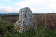
Neolithic and Bronze AgeSite Name: Cockrow Hill Bell Barrow Alternative Name: Ockham CommonCountry: England County: Surrey Type: Round Barrow(s)
Nearest Town: Cobham Nearest Village: Ockham
Map Ref: TQ07905915
Latitude: 51.321232N Longitude: 0.452971W
Condition:
| 5 | Perfect |
| 4 | Almost Perfect |
| 3 | Reasonable but with some damage |
| 2 | Ruined but still recognisable as an ancient site |
| 1 | Pretty much destroyed, possibly visible as crop marks |
| 0 | No data. |
| -1 | Completely destroyed |
| 5 | Superb |
| 4 | Good |
| 3 | Ordinary |
| 2 | Not Good |
| 1 | Awful |
| 0 | No data. |
| 5 | Can be driven to, probably with disabled access |
| 4 | Short walk on a footpath |
| 3 | Requiring a bit more of a walk |
| 2 | A long walk |
| 1 | In the middle of nowhere, a nightmare to find |
| 0 | No data. |
| 5 | co-ordinates taken by GPS or official recorded co-ordinates |
| 4 | co-ordinates scaled from a detailed map |
| 3 | co-ordinates scaled from a bad map |
| 2 | co-ordinates of the nearest village |
| 1 | co-ordinates of the nearest town |
| 0 | no data |
Internal Links:
External Links:
I have visited· I would like to visit
AdrianP visited on 6th Feb 2019 - their rating: Cond: 4 Amb: 3 Access: 4 Well maintained, impressive barrow spoilt only by the constant noise from neighbouring A3/M25 interchange. As we accessed via A3 hypocritical to moan too much! Will return to investigate second barrow and 'mound'.
Andy B have visited here
")
Excavation in 1911 yielded an unaccompanied cremation two feet below the top of the mound.
To visit this and the other nearby barrow, park in the Ockham Common Car Park (accessed from the M25 roundabout by going down the slip road leading to the southbound A3 and turn left onto Old Lane.) From the car park walk past the snack bar and north towards the footbridge over the A3. Go over the footbridge and follow the path to the right. Both barrows can be seen from the path. The area is great for cycling too.
More details at the Surrey HER database
Note: A recent drone image released by Highways England shows the progress of the M25/A3 junction work. I have highlighted the location of the barrow with an arrow (a bit below so as not to obscure it)
You may be viewing yesterday's version of this page. To see the most up to date information please register for a free account.
")
")
")
")
")
")
")
Do not use the above information on other web sites or publications without permission of the contributor.
Click here to see more info for this site
Nearby sites
Key: Red: member's photo, Blue: 3rd party photo, Yellow: other image, Green: no photo - please go there and take one, Grey: site destroyed
Download sites to:
KML (Google Earth)
GPX (GPS waypoints)
CSV (Garmin/Navman)
CSV (Excel)
To unlock full downloads you need to sign up as a Contributory Member. Otherwise downloads are limited to 50 sites.
Turn off the page maps and other distractions
Nearby sites listing. In the following links * = Image available
274m W 261° Bowl barrow west of Cockcrow Hill* Round Barrow(s) (TQ07635910)
755m NE 54° Red Hill (Surrey)* Henge (TQ08505961)
2.7km NNE 14° St George's Hill* Hillfort (TQ085618)
3.5km WNW 285° Jack Temple Healing Centre* Modern Stone Circle etc (TQ045600)
4.1km W 266° Pyrford Stone* Marker Stone (TQ0382258782)
6.3km W 277° Horsell Common E* Round Barrow(s) (TQ01615977)
6.5km W 277° Horsell Common W* Barrow Cemetery (TQ01405980)
8.8km NNW 335° Chertsey Museum Museum (TQ040670)
9.1km W 274° Horsell Birch Natural Stone / Erratic / Other Natural Feature (SU98805956)
9.2km N 360° Shepperton Henge* Henge (TQ07686832)
9.2km SW 236° Jacobs Well* Holy Well or Sacred Spring (TQ004538)
9.4km ESE 112° Thorncroft Spring (Leatherhead)* Holy Well or Sacred Spring (TQ167558)
9.7km E 86° Ashtead Common Earthwork* Misc. Earthwork (TQ176600)
9.7km WNW 300° Chobham Common (1)* Misc. Earthwork (SU994639)
10.0km WSW 237° Whitmoor Common* Round Barrow(s) (SU996536)
10.0km NNW 329° St Ann's Hill* Hillfort (TQ026676)
10.2km NNW 329° The Nun's Well (Surrey)* Holy Well or Sacred Spring (TQ0247767756)
10.3km WNW 303° Longcross Barrow* Round Barrow(s) (SU99126466)
10.6km NW 306° Flutters Hill Barrow* Round Barrow(s) (SU99206516)
10.7km S 191° The Silent Pool* Holy Well or Sacred Spring (TQ0606148582)
11.0km SSW 193° Weston Woods Cromlech* Standing Stones (TQ05644839)
11.0km SSW 194° Weston Wood Platform Mound* Round Barrow(s) (TQ055484)
11.1km NW 307° Barrowhills Round Barrow(s) (SU98866567)
11.4km ESE 114° Cherkley Court Barrows* Round Barrow(s) (TQ18385467)
11.4km SSW 194° Albury Fishponds* Natural Stone / Erratic / Other Natural Feature (TQ053480)
View more nearby sites and additional images


 We would like to know more about this location. Please feel free to add a brief description and any relevant information in your own language.
 Wir möchten mehr über diese Stätte erfahren. Bitte zögern Sie nicht, eine kurze Beschreibung und relevante Informationen in Deutsch hinzuzufügen.
 Nous aimerions en savoir encore un peu sur les lieux. S'il vous plaît n'hesitez pas à ajouter une courte description et tous les renseignements pertinents dans votre propre langue.
 Quisieramos informarnos un poco más de las lugares. No dude en añadir una breve descripción y otros datos relevantes en su propio idioma.