<< Text Pages >> Eglwys Faen Cave - Cave or Rock Shelter in Wales in Powys
Submitted by coldrum on Wednesday, 27 July 2011 Page Views: 5403
Natural PlacesSite Name: Eglwys Faen CaveCountry: Wales County: Powys Type: Cave or Rock Shelter
Map Ref: SO19261566
Latitude: 51.833693N Longitude: 3.173153W
Condition:
| 5 | Perfect |
| 4 | Almost Perfect |
| 3 | Reasonable but with some damage |
| 2 | Ruined but still recognisable as an ancient site |
| 1 | Pretty much destroyed, possibly visible as crop marks |
| 0 | No data. |
| -1 | Completely destroyed |
| 5 | Superb |
| 4 | Good |
| 3 | Ordinary |
| 2 | Not Good |
| 1 | Awful |
| 0 | No data. |
| 5 | Can be driven to, probably with disabled access |
| 4 | Short walk on a footpath |
| 3 | Requiring a bit more of a walk |
| 2 | A long walk |
| 1 | In the middle of nowhere, a nightmare to find |
| 0 | No data. |
| 5 | co-ordinates taken by GPS or official recorded co-ordinates |
| 4 | co-ordinates scaled from a detailed map |
| 3 | co-ordinates scaled from a bad map |
| 2 | co-ordinates of the nearest village |
| 1 | co-ordinates of the nearest town |
| 0 | no data |
Be the first person to rate this site - see the 'Contribute!' box in the right hand menu.
Internal Links:
External Links:
Cave or Rock Shelter in Powys
Coflein site entry:
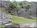
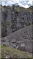
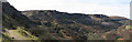
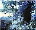
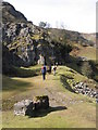
"The cave entrance to Eglwys Faen is situated about 460 m above O.D. It is but one of several caves believed to form part of a much larger underground system, (among the most extensive in Britain). This cave lies beneath the Craig y Ciliau."
https://www.coflein.gov.uk/en/site/292095
You may be viewing yesterday's version of this page. To see the most up to date information please register for a free account.
Do not use the above information on other web sites or publications without permission of the contributor.
Nearby Images from Geograph Britain and Ireland:
©2011(licence)
©2021(licence)
©2010(licence)
©2014(licence)
©2010(licence)
The above images may not be of the site on this page, they are loaded from Geograph.
Please Submit an Image of this site or go out and take one for us!
Click here to see more info for this site
Nearby sites
Key: Red: member's photo, Blue: 3rd party photo, Yellow: other image, Green: no photo - please go there and take one, Grey: site destroyed
Download sites to:
KML (Google Earth)
GPX (GPS waypoints)
CSV (Garmin/Navman)
CSV (Excel)
To unlock full downloads you need to sign up as a Contributory Member. Otherwise downloads are limited to 50 sites.
Turn off the page maps and other distractions
Nearby sites listing. In the following links * = Image available
321m SE 135° Cairn south of Eglwys Faen* Cairn (SO1948415430)
541m N 3° Coed Pentwyn* Hillfort (SO193162)
1.3km ESE 105° Ogof Darren Cilau Cave Cave or Rock Shelter (SO20511530)
1.5km SE 138° Mynydd Pen-cyrn Barrow Cemetery* Barrow Cemetery (SO20281449)
1.6km SE 138° Mynydd Pen-Cyrn Stone Circle* Stone Circle (SO2029214494)
2.0km W 264° Ty Aderyn cairn 2* Cairn (SO1724815473)
2.6km SE 128° Llanelly Round Barrow(s) (SO213140)
2.8km N 6° Ffawyddog Gaer Hillfort (SO196184)
2.8km NE 43° Garn Coch (Powys)* Chambered Tomb (SO2123617708)
2.9km NE 39° Llangattock Cross* Ancient Cross (SO2110017870)
3.2km NNE 24° Llan-Wysg Well* Holy Well or Sacred Spring (SO2060318584)
3.3km E 95° Gaer Settlement Ancient Village or Settlement (SO225153)
3.3km WNW 300° Carreg Waen Llech* Standing Stone (Menhir) (SO1638717378)
3.8km SE 127° Craig y Gaer* Hillfort (SO223133)
4.0km NNE 27° Gwernvale* Chambered Tomb (SO2111119217)
4.0km NE 45° Great Oak Stone* Standing Stone (Menhir) (SO22181846)
4.1km ENE 72° Cwrt-y-Gollen* Standing Stone (Menhir) (SO2324116860)
4.3km NNW 346° Penmyarth* Standing Stone (Menhir) (SO18291986)
4.6km NE 49° Llangenny Camp* Hillfort (SO228186)
4.7km SE 131° Twyn-y-Dinas Hillfort (SO228125)
5.2km ENE 64° Golden Grove* Standing Stone (Menhir) (SO2396217829)
5.4km NNW 339° Myarth Camp Hillfort (SO174207)
5.4km NE 54° Coed Ynys Faen* Standing Stones (SO237188)
5.7km SSE 159° Carreg Gywir Marker Stone (SO21191033)
5.7km NNE 13° Craig Llwyn* Ancient Village or Settlement (SO206212)
View more nearby sites and additional images


 We would like to know more about this location. Please feel free to add a brief description and any relevant information in your own language.
 Wir möchten mehr über diese Stätte erfahren. Bitte zögern Sie nicht, eine kurze Beschreibung und relevante Informationen in Deutsch hinzuzufügen.
 Nous aimerions en savoir encore un peu sur les lieux. S'il vous plaît n'hesitez pas à ajouter une courte description et tous les renseignements pertinents dans votre propre langue.
 Quisieramos informarnos un poco más de las lugares. No dude en añadir una breve descripción y otros datos relevantes en su propio idioma.