


<< Our Photo Pages >> Whitehill 3 - Rock Art in Scotland in East Dunbartonshire
Submitted by SolarMegalith on Saturday, 21 January 2017 Page Views: 2989
Rock ArtSite Name: Whitehill 3Country: Scotland County: East Dunbartonshire Type: Rock Art
Nearest Town: Clydebank
Map Ref: NS51157386
Latitude: 55.934684N Longitude: 4.384392W
Condition:
| 5 | Perfect |
| 4 | Almost Perfect |
| 3 | Reasonable but with some damage |
| 2 | Ruined but still recognisable as an ancient site |
| 1 | Pretty much destroyed, possibly visible as crop marks |
| 0 | No data. |
| -1 | Completely destroyed |
| 5 | Superb |
| 4 | Good |
| 3 | Ordinary |
| 2 | Not Good |
| 1 | Awful |
| 0 | No data. |
| 5 | Can be driven to, probably with disabled access |
| 4 | Short walk on a footpath |
| 3 | Requiring a bit more of a walk |
| 2 | A long walk |
| 1 | In the middle of nowhere, a nightmare to find |
| 0 | No data. |
| 5 | co-ordinates taken by GPS or official recorded co-ordinates |
| 4 | co-ordinates scaled from a detailed map |
| 3 | co-ordinates scaled from a bad map |
| 2 | co-ordinates of the nearest village |
| 1 | co-ordinates of the nearest town |
| 0 | no data |
Internal Links:
External Links:
I have visited· I would like to visit
SolarMegalith visited on 16th Sep 2016 - their rating: Cond: 3 Amb: 4 Access: 4
")
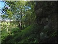
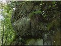
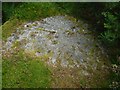
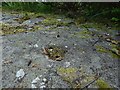
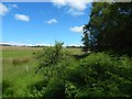
On a horizontal rock surface constituting part of a rocky crag there is a cup-and-ring mark with four rings. Currently it is difficult to distinguish due to lichen.
Canmore entry.
You may be viewing yesterday's version of this page. To see the most up to date information please register for a free account.
")
")
")
")
Do not use the above information on other web sites or publications without permission of the contributor.
Nearby Images from Geograph Britain and Ireland:
©2015(licence)
©2015(licence)
©2015(licence)
©2015(licence)
©2015(licence)
The above images may not be of the site on this page, they are loaded from Geograph.
Please Submit an Image of this site or go out and take one for us!
Click here to see more info for this site
Nearby sites
Key: Red: member's photo, Blue: 3rd party photo, Yellow: other image, Green: no photo - please go there and take one, Grey: site destroyed
Download sites to:
KML (Google Earth)
GPX (GPS waypoints)
CSV (Garmin/Navman)
CSV (Excel)
To unlock full downloads you need to sign up as a Contributory Member. Otherwise downloads are limited to 50 sites.
Turn off the page maps and other distractions
Nearby sites listing. In the following links * = Image available
192m NE 49° Whitehill 4* Rock Art (NS51307398)
285m NE 51° Whitehill 5* Rock Art (NS51387403)
684m W 281° Cochno Crags* Natural Stone / Erratic / Other Natural Feature (NS50487401)
698m W 270° The Cochno Stone* Rock Art (NS50457388)
809m W 272° Auchnacraig Stone Circle* Stone Circle (NS50347391)
890m WSW 252° Auchnacraig 4* Rock Art (NS50297362)
892m WSW 254° Auchnacraig 1* Rock Art (NS50287365)
1.1km WSW 254° Auchnacraig 5* Rock Art (NS501736)
1.8km SE 131° Castlehill Fort (Bearsden)* Hillfort (NS5248272614)
2.0km SW 234° Antonine Wall remains below Golden Hill* Stone Fort or Dun (NS49467274)
2.0km SW 232° Golden Hill Roman Fort* Stone Fort or Dun (NS49517265)
3.9km ESE 115° Bearsden Roman Bath-house* Stone Fort or Dun (NS54627208)
4.3km N 7° Craigenkirn (New Kilpatrick) Cairn (NS5183978157)
4.8km ESE 107° Antonine Wall, New Kilpatrick Cemetery* Misc. Earthwork (NS557723)
4.9km WSW 247° Kilpatrick Crannog Crannog (NS4658172121)
5.0km NE 47° Echo Stone (Mugdock) Natural Stone / Erratic / Other Natural Feature (NS54937710)
5.6km ENE 59° Middleton Row Stone Row / Alignment (NS561766)
5.7km WSW 258° Erskine Bridge Crannog Crannog (NS4548272901)
5.8km WSW 251° Erskine Park* Ancient Village or Settlement (NS45607220)
6.3km NNE 14° Craigmore Cottage Standing Stones (NS529799)
6.4km W 273° Hill of Dun* Hillfort (NS44807439)
6.6km NE 55° Loch Ardinning (Mugdock) Rock Art (NS567775)
7.1km NNW 342° The Whangie* Natural Stone / Erratic / Other Natural Feature (NS49238066)
7.2km ENE 71° Craigmaddie Muir 2 (Baldernock) Cairn (NS5876)
7.2km NNE 15° Blanefield* Stone Row / Alignment (NS53288072)
View more nearby sites and additional images


 We would like to know more about this location. Please feel free to add a brief description and any relevant information in your own language.
 Wir möchten mehr über diese Stätte erfahren. Bitte zögern Sie nicht, eine kurze Beschreibung und relevante Informationen in Deutsch hinzuzufügen.
 Nous aimerions en savoir encore un peu sur les lieux. S'il vous plaît n'hesitez pas à ajouter une courte description et tous les renseignements pertinents dans votre propre langue.
 Quisieramos informarnos un poco más de las lugares. No dude en añadir una breve descripción y otros datos relevantes en su propio idioma.