<< Our Photo Pages >> Eildon Hill North - Hillfort in Scotland in Scottish Borders
Submitted by Antonine on Thursday, 07 September 2023 Page Views: 740
Iron Age and Later PrehistorySite Name: Eildon Hill NorthCountry: Scotland County: Scottish Borders Type: Hillfort
Nearest Town: Melrose
Map Ref: NT55453280
Latitude: 55.586791N Longitude: 2.708333W
Condition:
| 5 | Perfect |
| 4 | Almost Perfect |
| 3 | Reasonable but with some damage |
| 2 | Ruined but still recognisable as an ancient site |
| 1 | Pretty much destroyed, possibly visible as crop marks |
| 0 | No data. |
| -1 | Completely destroyed |
| 5 | Superb |
| 4 | Good |
| 3 | Ordinary |
| 2 | Not Good |
| 1 | Awful |
| 0 | No data. |
| 5 | Can be driven to, probably with disabled access |
| 4 | Short walk on a footpath |
| 3 | Requiring a bit more of a walk |
| 2 | A long walk |
| 1 | In the middle of nowhere, a nightmare to find |
| 0 | No data. |
| 5 | co-ordinates taken by GPS or official recorded co-ordinates |
| 4 | co-ordinates scaled from a detailed map |
| 3 | co-ordinates scaled from a bad map |
| 2 | co-ordinates of the nearest village |
| 1 | co-ordinates of the nearest town |
| 0 | no data |
Internal Links:
External Links:
")
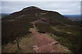
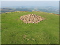
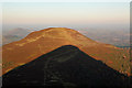
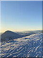
The Iron-Age Hillfort on the summit of Eildon Hill North was thought to be in use by the Romano-British Kingdom of Gododdin and a Roman Signal Station. It is the largest Hillfort in Scotland and has signs of settlement back to the Bronze Age.
canmore.org.uk/site/55668/eildon-hill-north
The Eildon Hills are also the setting for the story of Thomas the Rhymer and his journey into the realm of Faerie. Thomas, Laird of Ercildoune, was a real person who lived in the 13th century. The ruins of his tower can be seen at Earlston.
A horse trader, Canonbie Dick, claimed to have sold a horse to an old man, whom he followed to a cave inside what is now known as Little Hill on the southwest edge of the Eildon Hills. Inside lay the sleeping King Arthur and his Knights who were being provided horses by the old man. Some say the old man was Thomas the Rhymer.
You may be viewing yesterday's version of this page. To see the most up to date information please register for a free account.
Do not use the above information on other web sites or publications without permission of the contributor.
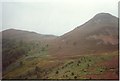
Nearby Images from Geograph Britain and Ireland:
©2020(licence)
©2008(licence)
©2008(licence)
©2015(licence)
©2023(licence)
The above images may not be of the site on this page, they are loaded from Geograph.
Please Submit an Image of this site or go out and take one for us!
Click here to see more info for this site
Nearby sites
Key: Red: member's photo, Blue: 3rd party photo, Yellow: other image, Green: no photo - please go there and take one, Grey: site destroyed
Download sites to:
KML (Google Earth)
GPX (GPS waypoints)
CSV (Garmin/Navman)
CSV (Excel)
To unlock full downloads you need to sign up as a Contributory Member. Otherwise downloads are limited to 50 sites.
Turn off the page maps and other distractions
Nearby sites listing. In the following links * = Image available
1.3km NE 53° Rhymer's Stone (Melrose)* Marker Stone (NT5651833592)
2.2km NE 45° Trimontium* Ancient Village or Settlement (NT57033435)
4.1km E 92° Font Stone (Dryburgh)* Ancient Cross (NT59543258)
5.5km ESE 110° Crystal Well (Benrig)* Holy Well or Sacred Spring (NT6064030847)
5.6km ESE 113° St Boswell's Old Church* Ancient Cross (NT6063730533)
5.7km ESE 114° Hier Well (Benrig)* Holy Well or Sacred Spring (NT60703042)
6.2km E 99° Mertoun Kirk (St Boswells)* Sculptured Stone (NT6155231821)
6.4km ESE 113° Maxton Burgh (St Boswells)* Ancient Cross (NT61333020)
7.2km ENE 63° Brothers' Stones* Standing Stones (NT61903600)
7.4km W 269° Rink Hill (Boleside) Hillfort (NT48023270)
7.5km ENE 62° Cow Stone (Scottish Borders)* Standing Stone (Menhir) (NT62163620)
8.1km NNE 31° Purveshaugh* Standing Stone (Menhir) (NT59663973)
8.9km WSW 237° Caulks Well (Selkirk)* Holy Well or Sacred Spring (NT4789127983)
9.3km NW 323° Hawksnest (Langshaw) Ring Cairn (NT499403)
9.4km WSW 238° Mungo's Well (Selkirk)* Holy Well or Sacred Spring (NT47342795)
10.4km SE 139° Ancrum Old Church* Sculptured Stone (NT6215024885)
10.5km SE 130° Harrietsfield Standing Stone (Menhir) (NT63442599)
10.5km SE 138° Castle Hill (Ancrum)* Hillfort (NT6239424909)
10.5km WNW 302° Torwoodlee* Broch or Nuraghe (NT46553847)
11.8km WNW 283° Caddonlee* Hillfort (NT43963551)
11.8km SE 129° Woodside (Crailing) Standing Stone (Menhir) (NT64552517)
11.9km E 96° The Law (Scottish Borders) Artificial Mound (NT6735831447)
12.0km ESE 110° Fairnington Stone Circle (NT667285)
12.2km SE 135° Harestanes (Ancrum) Stone Circle (NT640240)
12.3km SE 135° Harestanes (Ancrum) Stone Circle (NT641240)
View more nearby sites and additional images


 We would like to know more about this location. Please feel free to add a brief description and any relevant information in your own language.
 Wir möchten mehr über diese Stätte erfahren. Bitte zögern Sie nicht, eine kurze Beschreibung und relevante Informationen in Deutsch hinzuzufügen.
 Nous aimerions en savoir encore un peu sur les lieux. S'il vous plaît n'hesitez pas à ajouter une courte description et tous les renseignements pertinents dans votre propre langue.
 Quisieramos informarnos un poco más de las lugares. No dude en añadir una breve descripción y otros datos relevantes en su propio idioma.