


<< Our Photo Pages >> Damerham Knoll Camp - Hillfort in England in Hampshire
Submitted by JimChampion on Saturday, 23 April 2005 Page Views: 9655
Iron Age and Later PrehistorySite Name: Damerham Knoll CampCountry: England County: Hampshire Type: Hillfort
Nearest Town: Fordingbridge Nearest Village: Damerham
Map Ref: SU099185
Latitude: 50.965837N Longitude: 1.860394W
Condition:
| 5 | Perfect |
| 4 | Almost Perfect |
| 3 | Reasonable but with some damage |
| 2 | Ruined but still recognisable as an ancient site |
| 1 | Pretty much destroyed, possibly visible as crop marks |
| 0 | No data. |
| -1 | Completely destroyed |
| 5 | Superb |
| 4 | Good |
| 3 | Ordinary |
| 2 | Not Good |
| 1 | Awful |
| 0 | No data. |
| 5 | Can be driven to, probably with disabled access |
| 4 | Short walk on a footpath |
| 3 | Requiring a bit more of a walk |
| 2 | A long walk |
| 1 | In the middle of nowhere, a nightmare to find |
| 0 | No data. |
| 5 | co-ordinates taken by GPS or official recorded co-ordinates |
| 4 | co-ordinates scaled from a detailed map |
| 3 | co-ordinates scaled from a bad map |
| 2 | co-ordinates of the nearest village |
| 1 | co-ordinates of the nearest town |
| 0 | no data |
Internal Links:
External Links:
I have visited· I would like to visit
JimChampion has visited here
")
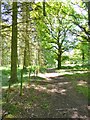
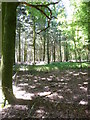
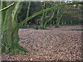
An Iron Age univallate hillfort on a ridge just northeast of Damerham Knoll. The defences are slight, almost puny, compared to the nearby Whitsbury hillfort and the enclosed area (roughly 150m in diameter) is now mostly overgrown with trees and brambles.
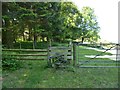
Access A footpath from Knap Barrow farm to Rockbourne runs SE along the ridge through the centre of the hillfort, leaving through the original SE entrance. An approach from any direction will require an uphill walk of at least 2km. This natural vantage point provides splendid views over the surrounding countryside, used by people throughout prehistory who have left their mark in the form of round and long barrows on the downs to the northeast.
You may be viewing yesterday's version of this page. To see the most up to date information please register for a free account.
")
")
")
")
Do not use the above information on other web sites or publications without permission of the contributor.
Nearby Images from Geograph Britain and Ireland:
©2013(licence)
©2013(licence)
©2019(licence)
©2006(licence)
©2013(licence)
The above images may not be of the site on this page, they are loaded from Geograph.
Please Submit an Image of this site or go out and take one for us!
Click here to see more info for this site
Nearby sites
Key: Red: member's photo, Blue: 3rd party photo, Yellow: other image, Green: no photo - please go there and take one, Grey: site destroyed
Download sites to:
KML (Google Earth)
GPX (GPS waypoints)
CSV (Garmin/Navman)
CSV (Excel)
To unlock full downloads you need to sign up as a Contributory Member. Otherwise downloads are limited to 50 sites.
Turn off the page maps and other distractions
Nearby sites listing. In the following links * = Image available
851m WNW 287° Knoll Down Tumulus* Round Barrow(s) (SU0908418750)
1.3km WNW 299° Knoll Down tumuli* Round Barrow(s) (SU088191)
1.6km NW 325° Grans Barrow* Long Barrow (SU090198)
1.7km NNW 327° Knap Barrow* Long Barrow (SU090199)
1.7km WSW 239° Soldiers Ring (Dorset)* Misc. Earthwork (SU084176)
2.0km NNE 18° Duck's Nest* Long Barrow (SU105204)
3.0km ENE 69° Whitsbury* Hillfort (SU127196)
3.3km SSW 199° Damerham Ceremonial Complex* Long Barrow (SU08841534)
3.5km W 264° Tidpit Common Down Long Barrow (SU064181)
3.7km N 4° Tenantry Farm* Long Barrow (SU10162219)
3.9km NNW 330° Furze Down Long Barrow (SU0791621895)
4.0km N 355° Grims Lodge Barrow* Long Barrow (SU0957722440)
4.1km WNW 301° Longbarrow House* Long Barrow (SU064206)
4.2km ENE 69° Giants Grave (Breamore)* Long Barrow (SU138200)
4.2km NNE 33° Whitsbury Down* Long Barrow (SU12212200)
4.3km W 264° Grim's Ditch (Hampshire) Misc. Earthwork (SU05651802)
4.4km NNE 17° Round Clump* Long Barrow (SU112227)
4.5km W 265° Blagdon Hill tumuli* Round Barrow(s) (SU054181)
4.6km ENE 67° Breamore Miz-Maze* Maze or Labyrinth (SU1412520266)
4.7km NE 52° Gallows Hill (Downton) Round Barrow(s) (SU13592136)
5.7km W 273° Pentridge 1* Long Barrow (SU04151877)
5.8km WNW 285° Martin Down Enclosure* Ancient Village or Settlement (SU043200)
5.8km W 276° Pentridge 2* Long Barrow (SU04111907)
5.9km W 277° Pentridge Cursus Cursus (SU040192)
6.1km W 280° Pentridge 3* Long Barrow (SU039195)
View more nearby sites and additional images


 We would like to know more about this location. Please feel free to add a brief description and any relevant information in your own language.
 Wir möchten mehr über diese Stätte erfahren. Bitte zögern Sie nicht, eine kurze Beschreibung und relevante Informationen in Deutsch hinzuzufügen.
 Nous aimerions en savoir encore un peu sur les lieux. S'il vous plaît n'hesitez pas à ajouter une courte description et tous les renseignements pertinents dans votre propre langue.
 Quisieramos informarnos un poco más de las lugares. No dude en añadir una breve descripción y otros datos relevantes en su propio idioma.