<< Our Photo Pages >> Caer Einon - Hillfort in Wales in Powys
Submitted by geoffstickland on Sunday, 03 January 2021 Page Views: 574
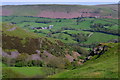
Iron Age and Later PrehistorySite Name: Caer EinonCountry: Wales County: Powys Type: Hillfort
Nearest Town: Builth Wells Nearest Village: Llanelwedd
Map Ref: SO06365309
Latitude: 52.168102N Longitude: 3.370553W
Condition:
| 5 | Perfect |
| 4 | Almost Perfect |
| 3 | Reasonable but with some damage |
| 2 | Ruined but still recognisable as an ancient site |
| 1 | Pretty much destroyed, possibly visible as crop marks |
| 0 | No data. |
| -1 | Completely destroyed |
| 5 | Superb |
| 4 | Good |
| 3 | Ordinary |
| 2 | Not Good |
| 1 | Awful |
| 0 | No data. |
| 5 | Can be driven to, probably with disabled access |
| 4 | Short walk on a footpath |
| 3 | Requiring a bit more of a walk |
| 2 | A long walk |
| 1 | In the middle of nowhere, a nightmare to find |
| 0 | No data. |
| 5 | co-ordinates taken by GPS or official recorded co-ordinates |
| 4 | co-ordinates scaled from a detailed map |
| 3 | co-ordinates scaled from a bad map |
| 2 | co-ordinates of the nearest village |
| 1 | co-ordinates of the nearest town |
| 0 | no data |
Internal Links:
External Links:
I have visited· I would like to visit
geoffstickland has visited here
")
You may be viewing yesterday's version of this page. To see the most up to date information please register for a free account.
Do not use the above information on other web sites or publications without permission of the contributor.
Nearby Images from Geograph Britain and Ireland:
©2018(licence)
©2018(licence)
©2018(licence)
©2018(licence)
©2018(licence)
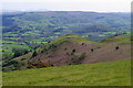
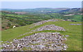
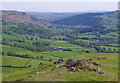
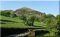
The above images may not be of the site on this page, they are loaded from Geograph.
Please Submit an Image of this site or go out and take one for us!
Click here to see more info for this site
Nearby sites
Key: Red: member's photo, Blue: 3rd party photo, Yellow: other image, Green: no photo - please go there and take one, Grey: site destroyed
Download sites to:
KML (Google Earth)
GPX (GPS waypoints)
CSV (Garmin/Navman)
CSV (Excel)
To unlock full downloads you need to sign up as a Contributory Member. Otherwise downloads are limited to 50 sites.
Turn off the page maps and other distractions
Nearby sites listing. In the following links * = Image available
435m NW 322° Carneddau Hill Stone* Standing Stone (Menhir) (SO06105344)
568m W 268° Gaer Fawr (Llanelwedd)* Hillfort (SO05795308)
862m N 354° Carneddau West* Cairn (SO06295395)
872m N 353° Newmead Farm Cairn 3* Cairn (SO0627153958)
1.0km NNE 14° Carneddau Hill Cairn* Cairn (SO06625407)
1.0km N 1° Four Parishes Standing Stone* Standing Stone (Menhir) (SO06395413)
1.4km N 356° Newmead Farm Cairn 2* Cairn (SO06295450)
1.5km N 357° Newmead Farm Cairn 1* Cairn (SO06305454)
1.7km NE 45° Cwm-Berwyn Round Cairn* Cairn (SO076543)
1.9km NNE 27° Cwmberwyn Camp* Hillfort (SO07275481)
2.2km N 8° Carneddau Hill Cairn II* Round Barrow(s) (SO06705527)
2.2km NE 52° Cilberllan Ring Cairn* Cairn (SO0815654436)
2.4km N 6° Carneddau Hill Cairn I.* Round Barrow(s) (SO06645544)
2.7km ENE 67° Bryntwppa* Stone Row / Alignment (SO08905410)
2.8km NE 51° The Gaer* Hillfort (SO08555480)
2.8km SSW 202° Garth Hill Fort* Hillfort (SO05285050)
2.8km W 263° Wellfield Hillfort* Hillfort (SO03555280)
2.9km W 267° Castell Caemardy* Artificial Mound (SO03465301)
3.0km SW 230° Builth Wells Gorsedd Circle* Modern Stone Circle etc (SO040512)
3.5km ENE 59° Perthi Common Cairns 1, 2, 3, 4* Cairn (SO0940654856)
3.8km SSE 155° Aberedw Hill Barrows* Barrow Cemetery (SO07914964)
3.8km NE 37° Castle Bank (Radnorshire)* Hillfort (SO08695608)
4.1km NNE 21° Upper House Cairns I,II & III* Cairn (SO079569)
4.1km SSE 157° Cefnhinog Standing Stone* Standing Stone (Menhir) (SO07944925)
4.3km NNE 29° Court Standing Stone* Standing Stone (Menhir) (SO08495680)
View more nearby sites and additional images


 We would like to know more about this location. Please feel free to add a brief description and any relevant information in your own language.
 Wir möchten mehr über diese Stätte erfahren. Bitte zögern Sie nicht, eine kurze Beschreibung und relevante Informationen in Deutsch hinzuzufügen.
 Nous aimerions en savoir encore un peu sur les lieux. S'il vous plaît n'hesitez pas à ajouter une courte description et tous les renseignements pertinents dans votre propre langue.
 Quisieramos informarnos un poco más de las lugares. No dude en añadir una breve descripción y otros datos relevantes en su propio idioma.