


<< Our Photo Pages >> Shahar Yeri - Ancient Village or Settlement in Iran
Submitted by Megalithic89 on Friday, 08 October 2021 Page Views: 15032
Multi-periodSite Name: Shahar YeriCountry: Iran
NOTE: This site is 47.084 km away from the location you searched for.
Type: Ancient Village or Settlement
Nearest Town: Meshgin Shahr Nearest Village: Pirazmiân
Latitude: 38.550460N Longitude: 47.925421E
Condition:
| 5 | Perfect |
| 4 | Almost Perfect |
| 3 | Reasonable but with some damage |
| 2 | Ruined but still recognisable as an ancient site |
| 1 | Pretty much destroyed, possibly visible as crop marks |
| 0 | No data. |
| -1 | Completely destroyed |
| 5 | Superb |
| 4 | Good |
| 3 | Ordinary |
| 2 | Not Good |
| 1 | Awful |
| 0 | No data. |
| 5 | Can be driven to, probably with disabled access |
| 4 | Short walk on a footpath |
| 3 | Requiring a bit more of a walk |
| 2 | A long walk |
| 1 | In the middle of nowhere, a nightmare to find |
| 0 | No data. |
| 5 | co-ordinates taken by GPS or official recorded co-ordinates |
| 4 | co-ordinates scaled from a detailed map |
| 3 | co-ordinates scaled from a bad map |
| 2 | co-ordinates of the nearest village |
| 1 | co-ordinates of the nearest town |
| 0 | no data |
Internal Links:
External Links:
I have visited· I would like to visit
schaaph would like to visit
")
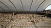
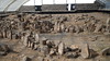
This ancient enclosure was researched during 10 years by an archaeology team from Manchester university until 1978. Three other times this ancient enclosure were researched by Iranian teams in 2003, 2004 and 2005. The third excavation season in 2005 has shown that Shahar Yeri was permanently populated from 7000 BC until the 1st millennium BC.
Excavations in 2005 allowed experts to discover some extraordinary things. The archaeological mission of Shahar Yeri found more than 300 menhirs there. […] These menhirs come in different sizes, dimensions and shapes. Their height varies from 35 cm to 250 cm. But the common feature of these menhirs is that they are cut and all represent the same image, with some differences in the details. They are human figures with hands, faces, eyes, hair and sword. But it’s curious to know that all those faces have no mouths! These menhirs are estimated to date from the middle of the second millennium to the middle of the first millennium BC.
Literature:
Les monhirs de Shahar Yeri, in: "La revue de Téhéran, No. 118, Sept. 2015", author Babak Ershadi.
You may be viewing yesterday's version of this page. To see the most up to date information please register for a free account.
Do not use the above information on other web sites or publications without permission of the contributor.
Nearby Images from Flickr
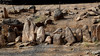
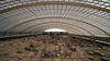
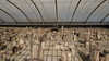
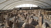
The above images may not be of the site on this page, but were taken nearby. They are loaded from Flickr so please click on them for image credits.
Click here to see more info for this site
Nearby sites
Click here to view sites on an interactive map of the areaKey: Red: member's photo, Blue: 3rd party photo, Yellow: other image, Green: no photo - please go there and take one, Grey: site destroyed
Download sites to:
KML (Google Earth)
GPX (GPS waypoints)
CSV (Garmin/Navman)
CSV (Excel)
To unlock full downloads you need to sign up as a Contributory Member. Otherwise downloads are limited to 50 sites.
Turn off the page maps and other distractions
Nearby sites listing. In the following links * = Image available
151.7km WSW 250° Yanik Tepe Ancient Village or Settlement
182.3km N 5° Whale Rock* Natural Stone / Erratic / Other Natural Feature
194.0km NW 304° Sangyar-Qaraberd Stone Row / Alignment
196.8km NW 304° Qaradaran Museum* Museum
198.0km NW 305° Karahoonj* Stone Circle
201.1km S 169° Chehr-Abad Salt Mine Ancient Mine, Quarry or other Industry
205.1km NW 309° Ughtasar* Rock Art
213.8km NE 35° The Gavel Dash* Natural Stone / Erratic / Other Natural Feature
213.9km NE 35° Gobustan Rock Art* Rock Art
214.0km NE 36° Gobustan* Ancient Village or Settlement
232.9km WNW 290° Duzdag Ancient Mine, Quarry or other Industry
233.7km NNE 29° Camel Hill* Natural Stone / Erratic / Other Natural Feature
236.9km NNE 31° Bosdag Chambered Cairn* Chambered Cairn
241.8km NNE 28° Bosdag Hill* Ancient Village or Settlement
241.8km NNE 28° Bosdag passageway* Rock Art
241.8km NNE 28° Bosdag* Natural Stone / Erratic / Other Natural Feature
244.9km NE 36° Turtle Rock* Rock Outcrop
248.0km NNE 29° Dragon Ditch* Misc. Earthwork
254.9km NE 37° Qobu* Rock Art
257.1km WNW 303° Tanahati* Early Christian Sculptured Stone
265.1km NE 39° Goztala settlement burial mounds Barrow Cemetery
268.9km WNW 300° Areni-1 Cave* Cave or Rock Shelter
270.8km NW 311° Khrber Ancient Village or Settlement
272.5km WNW 296° Ovchular Tepe Ancient Village or Settlement
274.6km NW 311° Odzaberd Promontory Fort / Cliff Castle
View more nearby sites and additional images


 We would like to know more about this location. Please feel free to add a brief description and any relevant information in your own language.
 Wir möchten mehr über diese Stätte erfahren. Bitte zögern Sie nicht, eine kurze Beschreibung und relevante Informationen in Deutsch hinzuzufügen.
 Nous aimerions en savoir encore un peu sur les lieux. S'il vous plaît n'hesitez pas à ajouter une courte description et tous les renseignements pertinents dans votre propre langue.
 Quisieramos informarnos un poco más de las lugares. No dude en añadir una breve descripción y otros datos relevantes en su propio idioma.