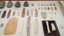
<< Our Photo Pages >> Museu de Prehistòria de València - Museum in Spain in Comunidad Valenciana
Submitted by TimPrevett on Sunday, 25 June 2017 Page Views: 6465
MuseumsSite Name: Museu de Prehistòria de València Alternative Name: Museum of Prehistoric ValenciaCountry: Spain
NOTE: This site is 21.865 km away from the location you searched for.
Region: Comunidad Valenciana Type: Museum
Nearest Town: Valencia
Latitude: 39.478274N Longitude: 0.383213W
Condition:
| 5 | Perfect |
| 4 | Almost Perfect |
| 3 | Reasonable but with some damage |
| 2 | Ruined but still recognisable as an ancient site |
| 1 | Pretty much destroyed, possibly visible as crop marks |
| 0 | No data. |
| -1 | Completely destroyed |
| 5 | Superb |
| 4 | Good |
| 3 | Ordinary |
| 2 | Not Good |
| 1 | Awful |
| 0 | No data. |
| 5 | Can be driven to, probably with disabled access |
| 4 | Short walk on a footpath |
| 3 | Requiring a bit more of a walk |
| 2 | A long walk |
| 1 | In the middle of nowhere, a nightmare to find |
| 0 | No data. |
| 5 | co-ordinates taken by GPS or official recorded co-ordinates |
| 4 | co-ordinates scaled from a detailed map |
| 3 | co-ordinates scaled from a bad map |
| 2 | co-ordinates of the nearest village |
| 1 | co-ordinates of the nearest town |
| 0 | no data |
Internal Links:
External Links:
Official website: here
You may be viewing yesterday's version of this page. To see the most up to date information please register for a free account.


Do not use the above information on other web sites or publications without permission of the contributor.
Click here to see more info for this site
Nearby sites
Click here to view sites on an interactive map of the areaKey: Red: member's photo, Blue: 3rd party photo, Yellow: other image, Green: no photo - please go there and take one, Grey: site destroyed
Download sites to:
KML (Google Earth)
GPX (GPS waypoints)
CSV (Garmin/Navman)
CSV (Excel)
To unlock full downloads you need to sign up as a Contributory Member. Otherwise downloads are limited to 50 sites.
Turn off the page maps and other distractions
Nearby sites listing. In the following links * = Image available
23.9km NNE 22° Seguntum* Ancient Village or Settlement
53.6km S 170° Parpalló Cave* Cave or Rock Shelter
58.2km SW 225° Cuevas de la Arana* Cave or Rock Shelter
59.5km SSE 163° Archaeological Museum of Gandia Museum
65.6km WNW 302° Cueva de la Vieja* Cave or Rock Shelter
81.7km SSE 168° Pla de Petrocas* Rock Art
84.7km NNE 29° Mortotum* Ancient Village or Settlement
106.8km NNE 12° Cueva Remigia* Cave or Rock Shelter
106.8km NNE 12° Cingle de la Mola* Cave or Rock Shelter
110.9km NW 324° Penalba de Villastar Castro or Chafurdão
113.0km NNW 327° Rodenas Castro or Chafurdão
115.1km SSW 214° Tobanilla Castro or Chafurdão
115.6km SSW 204° Cerro de los Moros Castro or Chafurdão
116.0km SW 222° La Cueva Horadada* Cave or Rock Shelter
116.1km SW 222° Cantos de la Visera Rock Art
117.1km SW 222° Petroglifos del Arabilejo Rock Art
117.1km SW 222° Las Cazoletas del Arabilejo Ancient Village or Settlement
119.6km SW 215° Abrigo del Canto de la Visera* Cave or Rock Shelter
121.4km WNW 295° Selva Pascuala cave mural Cave or Rock Shelter
124.0km NW 320° Pena de la Cruz Castro or Chafurdão
125.4km N 10° L'Argilagar II Burial Chamber or Dolmen
125.4km N 10° L'Argilagar VI Ancient Village or Settlement
125.5km N 10° L'Argilagar I Burial Chamber or Dolmen
128.6km N 11° Argilagar Castro or Chafurdão
132.0km WNW 302° Nuestra Senora del Pilar de Altarejos Castro or Chafurdão
View more nearby sites and additional images


