<< Our Photo Pages >> Besh Barmak Compass Stone - Rock Art in Azerbaijan
Submitted by AlexHunger on Sunday, 26 August 2007 Page Views: 8302
Rock ArtSite Name: Besh Barmak Compass StoneCountry: Azerbaijan
NOTE: This site is 83.206 km away from the location you searched for.
Type: Rock Art
Nearest Town: Baku
Latitude: 40.956330N Longitude: 49.214420E
Condition:
| 5 | Perfect |
| 4 | Almost Perfect |
| 3 | Reasonable but with some damage |
| 2 | Ruined but still recognisable as an ancient site |
| 1 | Pretty much destroyed, possibly visible as crop marks |
| 0 | No data. |
| -1 | Completely destroyed |
| 5 | Superb |
| 4 | Good |
| 3 | Ordinary |
| 2 | Not Good |
| 1 | Awful |
| 0 | No data. |
| 5 | Can be driven to, probably with disabled access |
| 4 | Short walk on a footpath |
| 3 | Requiring a bit more of a walk |
| 2 | A long walk |
| 1 | In the middle of nowhere, a nightmare to find |
| 0 | No data. |
| 5 | co-ordinates taken by GPS or official recorded co-ordinates |
| 4 | co-ordinates scaled from a detailed map |
| 3 | co-ordinates scaled from a bad map |
| 2 | co-ordinates of the nearest village |
| 1 | co-ordinates of the nearest town |
| 0 | no data |
Internal Links:
External Links:
")
This multi channeled stone is extremely intricate and has many similar features to oriented rock art that I have come across elsewhere in Azerbaijan.
( Ref http://azer.com/aiweb/categories/magazine/ai143_folder/143_articles/143_mt_index.html).
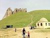
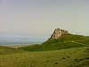
Because of its location, due west of an imposing rock crag called Besh Barmak, or Five fingered mountain which sits at the very end of the Caucasus mountain range I believe the site has ancient astronomical importance. The deepest channel runs through the central bowl or bullaun in a NW-SE direction, which is the orientation of the Caucasus mountain range. Coincidence??
This newly discovered ancient monument needs to be examined by archaeo astronomers to determine its significance and protected. I would welcome any comments on its features and information on any similar carvings from elsewhere.
Besh Barmak even today is considered a holy place and has numerous pilgrims and with many archaeological aspects of interest including numerous burial mounds is a potentially significant archeo site.
Kurgan.
You may be viewing yesterday's version of this page. To see the most up to date information please register for a free account.
Do not use the above information on other web sites or publications without permission of the contributor.
Nearby Images from Flickr
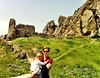
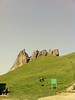
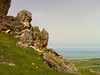
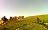
The above images may not be of the site on this page, but were taken nearby. They are loaded from Flickr so please click on them for image credits.
Click here to see more info for this site
Nearby sites
Click here to view sites on an interactive map of the areaKey: Red: member's photo, Blue: 3rd party photo, Yellow: other image, Green: no photo - please go there and take one, Grey: site destroyed
Download sites to:
KML (Google Earth)
GPX (GPS waypoints)
CSV (Garmin/Navman)
CSV (Excel)
To unlock full downloads you need to sign up as a Contributory Member. Otherwise downloads are limited to 50 sites.
Turn off the page maps and other distractions
Nearby sites listing. In the following links * = Image available
1.7km S 189° Besh Barmak Snake Figure* Hill Figure or Geoglyph
3.4km SSE 148° Besh Barmak* Natural Stone / Erratic / Other Natural Feature
52.9km SSE 168° Dragon Ditch* Misc. Earthwork
55.3km S 175° Bosdag Hill* Ancient Village or Settlement
55.3km S 175° Bosdag* Natural Stone / Erratic / Other Natural Feature
55.3km S 175° Bosdag passageway* Rock Art
64.0km S 176° Camel Hill* Natural Stone / Erratic / Other Natural Feature
66.0km S 170° Bosdag Chambered Cairn* Chambered Cairn
77.3km SSE 146° Qobu* Rock Art
79.5km SSE 154° Turtle Rock* Rock Outcrop
84.0km SE 138° Goztala settlement burial mounds Barrow Cemetery
94.9km S 172° Gobustan Rock Art* Rock Art
95.4km S 171° The Gavel Dash* Natural Stone / Erratic / Other Natural Feature
96.5km S 171° Gobustan* Ancient Village or Settlement
98.5km SE 125° Yeni Turcan Mound* Cairn
100.4km ESE 122° Süvalan Cart Ruts Ancient Trackway
102.0km SE 129° Yeni Turcan* Ancient Mine, Quarry or other Industry
103.8km ESE 122° Dubendi Cave* Cave or Rock Shelter
105.7km SE 127° Türkan Cart Ruts Ancient Trackway
126.5km SW 228° Whale Rock* Natural Stone / Erratic / Other Natural Feature
216.0km WNW 290° Perigala* Rock Art
228.5km NW 314° The oldest settlement Aynikab* Ancient Village or Settlement
284.4km WNW 290° Ananauri 3 Great Kurgan* Round Barrow(s)
289.3km SSW 203° Shahar Yeri* Ancient Village or Settlement
289.9km W 268° Tatarly Stone Age settlement Ancient Village or Settlement
View more nearby sites and additional images


 We would like to know more about this location. Please feel free to add a brief description and any relevant information in your own language.
 Wir möchten mehr über diese Stätte erfahren. Bitte zögern Sie nicht, eine kurze Beschreibung und relevante Informationen in Deutsch hinzuzufügen.
 Nous aimerions en savoir encore un peu sur les lieux. S'il vous plaît n'hesitez pas à ajouter une courte description et tous les renseignements pertinents dans votre propre langue.
 Quisieramos informarnos un poco más de las lugares. No dude en añadir una breve descripción y otros datos relevantes en su propio idioma.