<< Our Photo Pages >> Tabula Traiana - Carving in Serbia
Submitted by mfrincu on Tuesday, 18 August 2015 Page Views: 3426
Multi-periodSite Name: Tabula TraianaCountry: Serbia Type: Carving
Nearest Town: Kladovo
Latitude: 44.657778N Longitude: 22.311667E
Condition:
| 5 | Perfect |
| 4 | Almost Perfect |
| 3 | Reasonable but with some damage |
| 2 | Ruined but still recognisable as an ancient site |
| 1 | Pretty much destroyed, possibly visible as crop marks |
| 0 | No data. |
| -1 | Completely destroyed |
| 5 | Superb |
| 4 | Good |
| 3 | Ordinary |
| 2 | Not Good |
| 1 | Awful |
| 0 | No data. |
| 5 | Can be driven to, probably with disabled access |
| 4 | Short walk on a footpath |
| 3 | Requiring a bit more of a walk |
| 2 | A long walk |
| 1 | In the middle of nowhere, a nightmare to find |
| 0 | No data. |
| 5 | co-ordinates taken by GPS or official recorded co-ordinates |
| 4 | co-ordinates scaled from a detailed map |
| 3 | co-ordinates scaled from a bad map |
| 2 | co-ordinates of the nearest village |
| 1 | co-ordinates of the nearest town |
| 0 | no data |
Internal Links:
External Links:
I have visited· I would like to visit
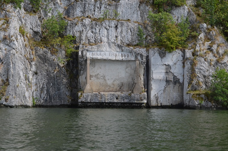
mfrincu visited on 17th Aug 2015 - their rating: Cond: 4 Amb: 5 Access: 5 A short 10 minute boat trip from the Romanian side took me to this ancient monument.

It marks the completion of the Roman military road. It is 4 meters wide and 1.75 meters high. A total of 10 plaques were erected and when the Danube is very low it is said one can spot 4 of them. The one currently visible was recovered by the Serbian authorities and raised about 30m from its original location once the Iron Dam 1 was finalized and the Danube levels in the region began to rise.
In English it reads:
"Emperor Caesar son of the divine Nerva, Nerva Trajan, the Augustus, Germanicus, Pontifex Maximus, invested for the fourth time as Tribune, Father of the Fatherland, Consul for the third time, excavating mountain rocks and using wood beams has made this road."
The site is easily spotted from the Romanian side and boat trips can be arranged for a reasonable price.
You may be viewing yesterday's version of this page. To see the most up to date information please register for a free account.
Do not use the above information on other web sites or publications without permission of the contributor.
Nearby Images from Flickr


The above images may not be of the site on this page, but were taken nearby. They are loaded from Flickr so please click on them for image credits.
Click here to see more info for this site
Nearby sites
Click here to view sites on an interactive map of the areaKey: Red: member's photo, Blue: 3rd party photo, Yellow: other image, Green: no photo - please go there and take one, Grey: site destroyed
Download sites to:
KML (Google Earth)
GPX (GPS waypoints)
CSV (Garmin/Navman)
CSV (Excel)
To unlock full downloads you need to sign up as a Contributory Member. Otherwise downloads are limited to 50 sites.
Turn off the page maps and other distractions
Nearby sites listing. In the following links * = Image available
2.5km SW 221° The face of Dacian King Decebalus* Sculptured Stone
23.4km E 98° Schela Cladovei* Ancient Village or Settlement
25.2km WSW 244° Lepenski Vir* Ancient Village or Settlement
28.4km E 98° Trajan's Roman Bridge* Ancient Trackway
39.2km SSW 210° Rudna Glava Ancient Mine, Quarry or other Industry
46.0km W 270° Chindiei 2 Cave* Rock Art
82.4km NE 51° Priest's Cave* Rock Art
83.9km S 182° Zaječar museum* Museum
85.0km S 187° Felix Romuliana* Ancient Palace
85.9km W 276° Viminacium* Ancient Village or Settlement
114.0km SW 220° Zavičajni Muzej Paraćin* Museum
116.9km NE 40° Banita Dacian citadel Hillfort
119.6km WSW 240° Grncarica Ancient Village or Settlement
123.8km NNE 32° Luncani-Piatra Rosie Dacian citadel* Hillfort
130.3km NNE 30° Ardeu Dacian Hillfort* Hillfort
130.3km NNE 30° Mihu Tower* Stone Fort or Dun
130.6km NNE 30° Costesti-Blidaru Dacian citadel* Hillfort
131.4km NNE 30° Costesti-Cetatuie Dacian citadel* Hillfort
132.7km NE 36° Sarmizegetusa Regia citadel* Hillfort
132.8km NE 36° Sarmizegetusa Regia Sacred Well* Holy Well or Sacred Spring
132.9km NE 36° Sarmizegetusa Regia Circle* Stone Circle
132.9km NE 36° Sarmizegetusa Regia Sanctuary* Ancient Temple
133.9km W 276° Vinca Belo Brdo* Ancient Village or Settlement
142.8km NW 319° Parta Neolithic Sanctuary* Ancient Temple
143.2km SW 214° Narodni Muzej Kruševac* Museum
View more nearby sites and additional images


 We would like to know more about this location. Please feel free to add a brief description and any relevant information in your own language.
 Wir möchten mehr über diese Stätte erfahren. Bitte zögern Sie nicht, eine kurze Beschreibung und relevante Informationen in Deutsch hinzuzufügen.
 Nous aimerions en savoir encore un peu sur les lieux. S'il vous plaît n'hesitez pas à ajouter une courte description et tous les renseignements pertinents dans votre propre langue.
 Quisieramos informarnos un poco más de las lugares. No dude en añadir una breve descripción y otros datos relevantes en su propio idioma.