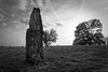
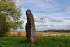
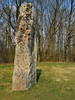
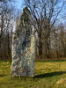
<< Our Photo Pages >> Verzieux de Gargantua Menhir - Standing Stone (Menhir) in France in Picardie:Aisne (02)
Submitted by AlexHunger on Thursday, 10 February 2005 Page Views: 6742
Neolithic and Bronze AgeSite Name: Verzieux de Gargantua MenhirCountry: France Département: Picardie:Aisne (02) Type: Standing Stone (Menhir)
Nearest Town: Saint-Quentin Nearest Village: Bois-les-Pargny
Latitude: 49.751000N Longitude: 3.654800E
Condition:
| 5 | Perfect |
| 4 | Almost Perfect |
| 3 | Reasonable but with some damage |
| 2 | Ruined but still recognisable as an ancient site |
| 1 | Pretty much destroyed, possibly visible as crop marks |
| 0 | No data. |
| -1 | Completely destroyed |
| 5 | Superb |
| 4 | Good |
| 3 | Ordinary |
| 2 | Not Good |
| 1 | Awful |
| 0 | No data. |
| 5 | Can be driven to, probably with disabled access |
| 4 | Short walk on a footpath |
| 3 | Requiring a bit more of a walk |
| 2 | A long walk |
| 1 | In the middle of nowhere, a nightmare to find |
| 0 | No data. |
| 5 | co-ordinates taken by GPS or official recorded co-ordinates |
| 4 | co-ordinates scaled from a detailed map |
| 3 | co-ordinates scaled from a bad map |
| 2 | co-ordinates of the nearest village |
| 1 | co-ordinates of the nearest town |
| 0 | no data |
Internal Links:
External Links:
I have visited· I would like to visit
Andy B has visited here
")
IMPORTANT NOTE: Positional co-ordinates scaled from a detailed map source.
You may be viewing yesterday's version of this page. To see the most up to date information please register for a free account.
")
")
Do not use the above information on other web sites or publications without permission of the contributor.
Nearby Images from Flickr
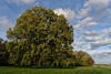
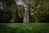
The above images may not be of the site on this page, but were taken nearby. They are loaded from Flickr so please click on them for image credits.
Click here to see more info for this site
Nearby sites
Click here to view sites on an interactive map of the areaKey: Red: member's photo, Blue: 3rd party photo, Yellow: other image, Green: no photo - please go there and take one, Grey: site destroyed
Download sites to:
KML (Google Earth)
GPX (GPS waypoints)
CSV (Garmin/Navman)
CSV (Excel)
To unlock full downloads you need to sign up as a Contributory Member. Otherwise downloads are limited to 50 sites.
Turn off the page maps and other distractions
Nearby sites listing. In the following links * = Image available
12.8km SSE 158° Allée Couverte de la Fontaine de Sambrecourt Passage Grave
20.4km NNE 24° Menhir de Chigny Standing Stone (Menhir)
24.3km ENE 61° Menhir dit la Haute Borne (La Bouteille)* Standing Stone (Menhir)
33.7km SW 227° Dolmen de Verneuil-sous-Coucy Burial Chamber or Dolmen
35.6km W 275° Menhir dit la Pierre à Bénie Standing Stone (Menhir)
37.9km SSE 153° Le Fond de Mauchamps Burial Chamber or Dolmen
40.5km NNW 333° Menhir de Clary* Standing Stone (Menhir)
41.4km SSE 168° Le Champ Tortu Burial Chamber or Dolmen
42.1km N 355° Le-Polissoir-d'Ors* Standing Stone (Menhir)
42.7km SSW 209° Pierre Frite de Crouy Natural Stone / Erratic / Other Natural Feature
43.9km WSW 243° Pierre de Saint-Hubert (B) Standing Stone (Menhir)
44.1km WSW 243° Pierre de Saint-Hubert (A) Standing Stone (Menhir)
44.3km SW 217° Dolmen dit la Pierre Laye* Burial Chamber or Dolmen
44.5km W 270° Alignement d'Eppeville* Stone Row / Alignment
46.7km NNE 28° Avesnes-Sur-Helpe Oppidum Hillfort
48.1km SSW 198° Allée Couverte de la Forte-Terre Burial Chamber or Dolmen
48.9km WSW 239° Grès de Saint-Lucien Standing Stone (Menhir)
51.0km ESE 117° Ecly Dolmen Burial Chamber or Dolmen
52.3km S 189° Banc des Trois-Seigneurs Rock Art
53.0km NNW 327° Cromlech de Niergnies* Stone Circle
53.5km WNW 291° Le Doigt de Gargantua (Doingt)* Standing Stone (Menhir)
53.8km NNE 30° La Pierre de Dessus-Bise* Standing Stone (Menhir)
53.9km NNE 30° Sars-Poteries* Standing Stones
54.6km WNW 286° Neolithic sites of Villers-Carbonnel* Ancient Village or Settlement
55.3km NNE 34° Les Pierres Martines* Standing Stone (Menhir)
View more nearby sites and additional images


 We would like to know more about this location. Please feel free to add a brief description and any relevant information in your own language.
 Wir möchten mehr über diese Stätte erfahren. Bitte zögern Sie nicht, eine kurze Beschreibung und relevante Informationen in Deutsch hinzuzufügen.
 Nous aimerions en savoir encore un peu sur les lieux. S'il vous plaît n'hesitez pas à ajouter une courte description et tous les renseignements pertinents dans votre propre langue.
 Quisieramos informarnos un poco más de las lugares. No dude en añadir una breve descripción y otros datos relevantes en su propio idioma.