<< Our Photo Pages >> St. Margaret's Well (Mugswell) - Holy Well or Sacred Spring in England in Surrey
Submitted by DavidCWoods on Friday, 26 November 2004 Page Views: 10461
Springs and Holy WellsSite Name: St. Margaret's Well (Mugswell) Alternative Name: Mag's Well, MugswellCountry: England County: Surrey Type: Holy Well or Sacred Spring
Nearest Town: Reigate Nearest Village: Mugswell
Map Ref: TQ258553
Latitude: 51.282958N Longitude: 0.19758W
Condition:
| 5 | Perfect |
| 4 | Almost Perfect |
| 3 | Reasonable but with some damage |
| 2 | Ruined but still recognisable as an ancient site |
| 1 | Pretty much destroyed, possibly visible as crop marks |
| 0 | No data. |
| -1 | Completely destroyed |
| 5 | Superb |
| 4 | Good |
| 3 | Ordinary |
| 2 | Not Good |
| 1 | Awful |
| 0 | No data. |
| 5 | Can be driven to, probably with disabled access |
| 4 | Short walk on a footpath |
| 3 | Requiring a bit more of a walk |
| 2 | A long walk |
| 1 | In the middle of nowhere, a nightmare to find |
| 0 | No data. |
| 5 | co-ordinates taken by GPS or official recorded co-ordinates |
| 4 | co-ordinates scaled from a detailed map |
| 3 | co-ordinates scaled from a bad map |
| 2 | co-ordinates of the nearest village |
| 1 | co-ordinates of the nearest town |
| 0 | no data |
Internal Links:
External Links:
 (PID:10787)")
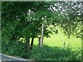
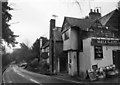
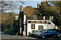
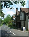
You could say that this well is ideally positioned - in the garden of a CAMRA recommended pub ! The pub is the Well House, on Chipstead Lane, quite close to Junction 8 of the M25. I visited in a snowstorm, the first of the year (for me, anyway). A notice on the well, which is of the wishing well type, complete with bucket, says that it is thought to be the one mentioned in the Domesday Book, and that the village of Mugswell derives its name from here. Possible problems with this are that the village is about half a mile away up the hill and the the road leading to it is called Monkswell Lane. Whether this is the well referred to in the road name or whether there is another I am not yet sure.
You may be viewing yesterday's version of this page. To see the most up to date information please register for a free account.
 (PID:60256)")
 (PID:10789)")
 (PID:10788)")
Do not use the above information on other web sites or publications without permission of the contributor.
Nearby Images from Geograph Britain and Ireland:
©2012(licence)
©2012(licence)
©2007(licence)

©2010(licence)
©2012(licence)
The above images may not be of the site on this page, they are loaded from Geograph.
Please Submit an Image of this site or go out and take one for us!
Click here to see more info for this site
Nearby sites
Key: Red: member's photo, Blue: 3rd party photo, Yellow: other image, Green: no photo - please go there and take one, Grey: site destroyed
Download sites to:
KML (Google Earth)
GPX (GPS waypoints)
CSV (Garmin/Navman)
CSV (Excel)
To unlock full downloads you need to sign up as a Contributory Member. Otherwise downloads are limited to 50 sites.
Turn off the page maps and other distractions
Nearby sites listing. In the following links * = Image available
2.5km NE 54° Chipstead Well Holy Well or Sacred Spring (TQ278568)
2.9km SSE 155° Gatton Park, The Millennium Stones* Modern Stone Circle etc (TQ271527)
4.9km ENE 61° Farthing Downs* Barrow Cemetery (TQ300578)
5.1km E 87° St Peter and St Paul's Church (Chaldon)* Ancient Cross (TQ3087455694)
5.3km SSE 166° Waterslade Spring Holy Well or Sacred Spring (TQ272502)
5.3km SSW 204° Reigate Heath Barrows* Barrow Cemetery (TQ23725042)
5.4km SSE 165° Whitepost Hill Spring Holy Well or Sacred Spring (TQ273501)
5.5km N 352° Gally Hills Barrow Cemetery (TQ249607)
5.9km SSE 166° Redhill Common* Round Barrow(s) (TQ274496)
6.6km W 276° Thirty Acre Barn Barrows Round Barrow(s) (TQ192558)
6.7km ESE 111° Spring Bottom* Holy Well or Sacred Spring (TQ321531)
6.7km S 175° Earlswood Common Barrow Cemetery Barrow Cemetery (TQ266486)
7.1km SSE 161° Royal Earlswood Stones* Modern Stone Circle etc (TQ283487)
7.4km W 267° Cherkley Court Barrows* Round Barrow(s) (TQ18385467)
7.4km ESE 107° War Coppice Camp Hillfort (TQ32985326)
7.8km ESE 116° North Park Farm* Ancient Village or Settlement (TQ329520)
8.0km NNW 336° Hatch Furlong Ritual Shafts* Misc. Earthwork (TQ223625)
8.2km WSW 243° Box Hill Bowl Barrow 2* Round Barrow(s) (TQ18575132)
8.4km NE 52° Riddlesdown Newe Ditch* Misc. Earthwork (TQ3230460572)
8.4km NNW 334° Ewell Springs (Surrey)* Holy Well or Sacred Spring (TQ219627)
8.4km NNW 333° Bourne Hall Museum* Museum (TQ218627)
8.7km WSW 243° Box Hill Bowl Barrow 1* Round Barrow(s) (TQ18065121)
9.1km W 275° Thorncroft Spring (Leatherhead)* Holy Well or Sacred Spring (TQ167558)
9.4km WNW 301° Ashtead Common Earthwork* Misc. Earthwork (TQ176600)
9.4km NNE 14° Queen Anne's Well (Carshalton)* Holy Well or Sacred Spring (TQ279645)
View more nearby sites and additional images


 We would like to know more about this location. Please feel free to add a brief description and any relevant information in your own language.
 Wir möchten mehr über diese Stätte erfahren. Bitte zögern Sie nicht, eine kurze Beschreibung und relevante Informationen in Deutsch hinzuzufügen.
 Nous aimerions en savoir encore un peu sur les lieux. S'il vous plaît n'hesitez pas à ajouter une courte description et tous les renseignements pertinents dans votre propre langue.
 Quisieramos informarnos un poco más de las lugares. No dude en añadir una breve descripción y otros datos relevantes en su propio idioma.