<< Our Photo Pages >> Skokholm - Not Known (by us) in Wales in Pembrokeshire
Submitted by PAB on Monday, 21 July 2014 Page Views: 3626
Date UncertainSite Name: SkokholmCountry: Wales County: Pembrokeshire Type: Not Known (by us)
Map Ref: SM731045
Latitude: 51.693272N Longitude: 5.284475W
Condition:
| 5 | Perfect |
| 4 | Almost Perfect |
| 3 | Reasonable but with some damage |
| 2 | Ruined but still recognisable as an ancient site |
| 1 | Pretty much destroyed, possibly visible as crop marks |
| 0 | No data. |
| -1 | Completely destroyed |
| 5 | Superb |
| 4 | Good |
| 3 | Ordinary |
| 2 | Not Good |
| 1 | Awful |
| 0 | No data. |
| 5 | Can be driven to, probably with disabled access |
| 4 | Short walk on a footpath |
| 3 | Requiring a bit more of a walk |
| 2 | A long walk |
| 1 | In the middle of nowhere, a nightmare to find |
| 0 | No data. |
| 5 | co-ordinates taken by GPS or official recorded co-ordinates |
| 4 | co-ordinates scaled from a detailed map |
| 3 | co-ordinates scaled from a bad map |
| 2 | co-ordinates of the nearest village |
| 1 | co-ordinates of the nearest town |
| 0 | no data |
Internal Links:
External Links:
I have visited· I would like to visit
PAB has visited here
")
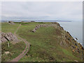
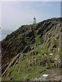
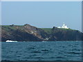
I could find no reference to there being a 'verified' dolmen on Skokholm, and the Warden said that he understood there to have been a fairly recent archaeological survey which had not identified any remaining traces of the ancient uses of the island.
Despite the absence of anything on Coflein etc, I felt that there was more than 'Natural erratic' to this feature, so I am posting it in the hope that others might know more or be able to investigate it. The Old Red Sandstone in this stretch of the cliff is very similar to King's Quoit, Manorbier - also of course a significant earth-fast 'slab' with support....
As the ground is very fragile from the high concentration of bird and rabbit burrows, it wasn't possible to get any 'interior' pictures, but I will ask the Warden to get some to post. It also happens to be rather steep along this stretch of cliff!
I was very tempted to give a description as 'Burial Chamber - Dolmen', but have chosen the safer 'Not Known' option for now, awaiting comments!
You may be viewing yesterday's version of this page. To see the most up to date information please register for a free account.
")
")
Do not use the above information on other web sites or publications without permission of the contributor.
Nearby Images from Geograph Britain and Ireland:
©2018(licence)
©2010(licence)
©2006(licence)
©2010(licence)
©2007(licence)
The above images may not be of the site on this page, they are loaded from Geograph.
Please Submit an Image of this site or go out and take one for us!
Click here to see more info for this site
Nearby sites
Key: Red: member's photo, Blue: 3rd party photo, Yellow: other image, Green: no photo - please go there and take one, Grey: site destroyed
Download sites to:
KML (Google Earth)
GPX (GPS waypoints)
CSV (Garmin/Navman)
CSV (Excel)
To unlock full downloads you need to sign up as a Contributory Member. Otherwise downloads are limited to 50 sites.
Turn off the page maps and other distractions
Nearby sites listing. In the following links * = Image available
4.4km N 4° South Castle Promontory Fort Promontory Fort / Cliff Castle (SM73590892)
4.5km NE 52° Gateholm Island* Ancient Village or Settlement (SM768071)
4.7km NNW 343° Skomer south west settlements* Ancient Village or Settlement (SM71900910)
4.8km NNW 340° Skomer Island Stone Row / Alignment (SM71620911)
5.0km N 0° Skomer Stone* Standing Stone (Menhir) (SM73360952)
5.1km NE 46° Victoria Bay* Hillfort (SM769079)
5.2km NNE 30° Martin's Haven* Hillfort (SM759089)
5.3km NNE 31° Renney Slip Hillfort (SM760089)
5.4km NNE 31° Ring-Stone, Martin's Haven* Early Christian Sculptured Stone (SM761090)
5.4km N 350° North Skomer settlement Ancient Village or Settlement (SM7240009900)
5.5km N 353° Earthfast natural slab in north east Skomer* Natural Stone / Erratic / Other Natural Feature (SM72660998)
6.6km E 93° Little Castle Point Hillfort (SM797038)
6.9km ENE 77° Great Castle Head Hillfort (SM799057)
8.6km NE 40° Tower Point* Promontory Fort / Cliff Castle (SM790108)
8.9km NE 39° Nab Head (Pembrokeshire)* Ancient Village or Settlement (SM79051111)
9.1km E 83° Dale Fort* Hillfort (SM822052)
10.2km ENE 70° Mabesgate Longstone* Standing Stone (Menhir) (SM828076)
11.8km E 101° Whitedole Bay Hillfort (SM846018)
12.3km ENE 69° Sandy Haven's Farm* Standing Stone (Menhir) (SM848084)
12.4km ENE 69° Longstone Field Standing Stone (Menhir) (SM84870842)
12.4km ENE 69° Longstone Field Circle 1 Timber Circle (SM849084)
12.4km ENE 69° Longstone Field Circle 2 Timber Circle (SM849084)
13.6km ESE 102° Pickard Head Hillfort (SM863011)
14.0km WNW 287° Grassholm Island* Ancient Village or Settlement (SM5985909317)
15.9km E 101° The Devil's Quoit* Burial Chamber or Dolmen (SM88650084)
View more nearby sites and additional images


 We would like to know more about this location. Please feel free to add a brief description and any relevant information in your own language.
 Wir möchten mehr über diese Stätte erfahren. Bitte zögern Sie nicht, eine kurze Beschreibung und relevante Informationen in Deutsch hinzuzufügen.
 Nous aimerions en savoir encore un peu sur les lieux. S'il vous plaît n'hesitez pas à ajouter une courte description et tous les renseignements pertinents dans votre propre langue.
 Quisieramos informarnos un poco más de las lugares. No dude en añadir una breve descripción y otros datos relevantes en su propio idioma.