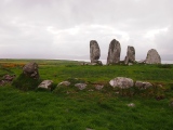
<< Our Photo Pages >> Eightercua - Stone Row / Alignment in Ireland (Republic of) in Co. Kerry
Submitted by Tom_Bullock on Tuesday, 01 October 2002 Page Views: 14335
Neolithic and Bronze AgeSite Name: EightercuaCountry: Ireland (Republic of)
NOTE: This site is 1.579 km away from the location you searched for.
County: Co. Kerry Type: Stone Row / Alignment
Nearest Town: Waterville Nearest Village: Eightercua
Map Ref: V51206465
Discovery Map Number: D83
Latitude: 51.814848N Longitude: 10.15851W
Condition:
| 5 | Perfect |
| 4 | Almost Perfect |
| 3 | Reasonable but with some damage |
| 2 | Ruined but still recognisable as an ancient site |
| 1 | Pretty much destroyed, possibly visible as crop marks |
| 0 | No data. |
| -1 | Completely destroyed |
| 5 | Superb |
| 4 | Good |
| 3 | Ordinary |
| 2 | Not Good |
| 1 | Awful |
| 0 | No data. |
| 5 | Can be driven to, probably with disabled access |
| 4 | Short walk on a footpath |
| 3 | Requiring a bit more of a walk |
| 2 | A long walk |
| 1 | In the middle of nowhere, a nightmare to find |
| 0 | No data. |
| 5 | co-ordinates taken by GPS or official recorded co-ordinates |
| 4 | co-ordinates scaled from a detailed map |
| 3 | co-ordinates scaled from a bad map |
| 2 | co-ordinates of the nearest village |
| 1 | co-ordinates of the nearest town |
| 0 | no data |
Internal Links:
External Links:
I have visited· I would like to visit
DrewParsons Kith Jdmueller6 rrmoser would like to visit
jeffrep visited on 27th Apr 2008 - their rating: Cond: 3 Amb: 5 Access: 2
Klingon visited on 25th Mar 2005 - their rating: Cond: 3 Amb: 5 Access: 2
Runemage visited There was no public access when I visited and none of the images we have seem to be taken close to these stones. They are easily visible from the road.
Average ratings for this site from all visit loggers: Condition: 3 Ambience: 5 Access: 2
Row length: 30 feet, Number of stones: 4
This is a very impressive stone row with four very large stones up to ten feet in height, extending E-W for 30 feet. The S side shows evidence of an enclosure (or base of a cairn). Remnants of a tomb adjacent to it are visible as well. Request access at the small withe bungalow near the place.
You may be viewing yesterday's version of this page. To see the most up to date information please register for a free account.


Do not use the above information on other web sites or publications without permission of the contributor.
Click here to see more info for this site
Nearby sites
Click here to view sites on an interactive map of the areaKey: Red: member's photo, Blue: 3rd party photo, Yellow: other image, Green: no photo - please go there and take one, Grey: site destroyed
Download sites to:
KML (Google Earth)
GPX (GPS waypoints)
CSV (Garmin/Navman)
CSV (Excel)
To unlock full downloads you need to sign up as a Contributory Member. Otherwise downloads are limited to 50 sites.
Turn off the page maps and other distractions
Nearby sites listing. In the following links * = Image available
3.2km NW 315° Spuncane Stone Circle (V490670)
3.2km S 189° Loher Stone Fort* Hillfort
4.5km S 184° Coomatloukane* Wedge Tomb (V5074660179)
4.7km NE 36° Dromkeare Stone Row / Alignment
5.8km NNE 33° Dromod* Stone Circle (V545694)
5.9km SSE 147° Caherdaniel Fort (2)* Stone Fort or Dun (V5425059627)
5.9km SE 130° Coomnahorna* Standing Stones
5.9km SSE 146° Caherdaniel Fort (1)* Stone Fort or Dun (V5434559619)
6.2km SSE 156° The Derrynane Stone* Standing Stone (Menhir) (V5356258932)
6.9km NE 43° Cahersavane* Standing Stones (V5605769610)
7.0km NNE 34° Dromod Stone Row* Stone Row / Alignment
7.1km NNE 26° Doory row Stone Row / Alignment
7.2km NNE 27° Doory standing stone Standing Stone (Menhir)
8.7km NE 38° Derrineden W Stone Row / Alignment
9.3km NE 39° Derrineden E Stone Row / Alignment
9.7km NW 321° Fermoyle Stone Row / Alignment (V453724)
9.9km E 96° Staigue* Stone Fort or Dun (V6103463272)
10.2km W 263° Kildreelig* Stone Row / Alignment
10.3km ESE 115° White Strand Modern Stone Circle and Dolmen* Modern Stone Circle etc (V6046959977)
10.7km W 275° Coom Wedge Tomb* Wedge Tomb
11.1km WNW 291° Leabaleaha Stone Circle (V410690)
11.7km W 260° Bolus Standing Stones (V396630)
12.1km WNW 291° St Buonia's Cross (Killabuonia) Early Christian Sculptured Stone (V4002269422)
12.3km E 98° Derreenauliff Stone Row / Alignment
12.6km N 355° Canburrin Standing Stones
View more nearby sites and additional images


