<< Our Photo Pages >> St Brendan's Well - Holy Well or Sacred Spring in Ireland (Republic of) in Co. Kerry
Submitted by ladrin on Sunday, 04 October 2015 Page Views: 2236
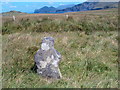
Springs and Holy WellsSite Name: St Brendan's WellCountry: Ireland (Republic of)
NOTE: This site is 1.78 km away from the location you searched for.
County: Co. Kerry Type: Holy Well or Sacred Spring
Nearest Town: Portmagee
Latitude: 51.910254N Longitude: 10.398696W
Condition:
| 5 | Perfect |
| 4 | Almost Perfect |
| 3 | Reasonable but with some damage |
| 2 | Ruined but still recognisable as an ancient site |
| 1 | Pretty much destroyed, possibly visible as crop marks |
| 0 | No data. |
| -1 | Completely destroyed |
| 5 | Superb |
| 4 | Good |
| 3 | Ordinary |
| 2 | Not Good |
| 1 | Awful |
| 0 | No data. |
| 5 | Can be driven to, probably with disabled access |
| 4 | Short walk on a footpath |
| 3 | Requiring a bit more of a walk |
| 2 | A long walk |
| 1 | In the middle of nowhere, a nightmare to find |
| 0 | No data. |
| 5 | co-ordinates taken by GPS or official recorded co-ordinates |
| 4 | co-ordinates scaled from a detailed map |
| 3 | co-ordinates scaled from a bad map |
| 2 | co-ordinates of the nearest village |
| 1 | co-ordinates of the nearest town |
| 0 | no data |
Internal Links:
External Links:
")
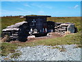
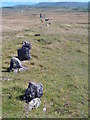
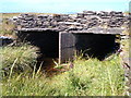
Holly well nearly at the end of the world.. Hidden in remote waste land of Valentia Island, this site includes restored holly well and three old stone crosses. The legend says that St. Brendan baptised two dying pagan here and so brought Christianity to the island.
You may be viewing yesterday's version of this page. To see the most up to date information please register for a free account.
")
")
")
")
Do not use the above information on other web sites or publications without permission of the contributor.
Nearby Images from Geograph Britain and Ireland:
©2010(licence)
©2010(licence)
©2010(licence)
©2012(licence)
©2010(licence)
The above images may not be of the site on this page, they are loaded from Geograph.
Please Submit an Image of this site or go out and take one for us!
Click here to see more info for this site
Nearby sites
Click here to view sites on an interactive map of the areaKey: Red: member's photo, Blue: 3rd party photo, Yellow: other image, Green: no photo - please go there and take one, Grey: site destroyed
Download sites to:
KML (Google Earth)
GPX (GPS waypoints)
CSV (Garmin/Navman)
CSV (Excel)
To unlock full downloads you need to sign up as a Contributory Member. Otherwise downloads are limited to 50 sites.
Turn off the page maps and other distractions
Nearby sites listing. In the following links * = Image available
2.5km E 95° Cool East ogham stone* Standing Stone (Menhir)
2.6km E 87° Cool East wedge tomb* Wedge Tomb
3.2km ENE 66° Tinnies Upper Stone Circle (V380770)
5.8km ENE 65° Glanleam standing stone* Standing Stone (Menhir)
8.1km SE 140° St Buonia's Cross (Killabuonia) Early Christian Sculptured Stone (V4002269422)
9.0km ENE 64° Ballycarbery west wedge tomb* Wedge Tomb
9.0km SE 137° Leabaleaha Stone Circle (V410690)
9.2km NE 56° Doulus Head Hut Sites* Ancient Village or Settlement
10.8km ESE 106° Fermoyle Stone Row / Alignment (V453724)
10.9km ENE 62° Cahergal* Stone Fort or Dun (V4484180557)
11.0km ENE 59° Leacanabuaile* Stone Fort or Dun (V4463781059)
11.2km ENE 61° Kimego Standing Stones (V450808)
11.3km SSE 149° Coom Wedge Tomb* Wedge Tomb
12.1km ENE 73° Cahersiveen standing stones* Standing Stones (V4674478981)
13.5km SSE 152° Kildreelig* Stone Row / Alignment
13.6km SSE 158° Bolus Standing Stones (V396630)
15.5km E 83° Canburrin Standing Stones
16.5km ESE 120° Spuncane Stone Circle (V490670)
18.1km ENE 75° Srugreana Standing Stone (Menhir)
18.2km SSW 214° Skellig Michael* Early Christian Sculptured Stone (V244610)
19.1km ENE 69° Ballynahow Beg* Rock Art (V5305682093)
19.6km ESE 123° Eightercua* Stone Row / Alignment (V51206465)
20.0km ESE 102° Doory row Stone Row / Alignment
20.1km ESE 102° Doory standing stone Standing Stone (Menhir)
20.4km ESE 109° Dromkeare Stone Row / Alignment
View more nearby sites and additional images


 We would like to know more about this location. Please feel free to add a brief description and any relevant information in your own language.
 Wir möchten mehr über diese Stätte erfahren. Bitte zögern Sie nicht, eine kurze Beschreibung und relevante Informationen in Deutsch hinzuzufügen.
 Nous aimerions en savoir encore un peu sur les lieux. S'il vous plaît n'hesitez pas à ajouter une courte description et tous les renseignements pertinents dans votre propre langue.
 Quisieramos informarnos un poco más de las lugares. No dude en añadir una breve descripción y otros datos relevantes en su propio idioma.