<< Our Photo Pages >> An Gráig standing stone - Standing Stone (Menhir) in Ireland (Republic of) in Co. Kerry
Submitted by GaelicLaird on Thursday, 30 September 2021 Page Views: 971
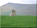
Neolithic and Bronze AgeSite Name: An Gráig standing stone Alternative Name: Graigue standing stoneCountry: Ireland (Republic of) County: Co. Kerry Type: Standing Stone (Menhir)
Nearest Village: Lispole
Latitude: 52.136173N Longitude: 10.145284W
Condition:
| 5 | Perfect |
| 4 | Almost Perfect |
| 3 | Reasonable but with some damage |
| 2 | Ruined but still recognisable as an ancient site |
| 1 | Pretty much destroyed, possibly visible as crop marks |
| 0 | No data. |
| -1 | Completely destroyed |
| 5 | Superb |
| 4 | Good |
| 3 | Ordinary |
| 2 | Not Good |
| 1 | Awful |
| 0 | No data. |
| 5 | Can be driven to, probably with disabled access |
| 4 | Short walk on a footpath |
| 3 | Requiring a bit more of a walk |
| 2 | A long walk |
| 1 | In the middle of nowhere, a nightmare to find |
| 0 | No data. |
| 5 | co-ordinates taken by GPS or official recorded co-ordinates |
| 4 | co-ordinates scaled from a detailed map |
| 3 | co-ordinates scaled from a bad map |
| 2 | co-ordinates of the nearest village |
| 1 | co-ordinates of the nearest town |
| 0 | no data |
Internal Links:
External Links:
")
Located on level ground at the E end of the Sea Hill ridge, this stone has split vertically into 2 separate slabs. The greater portion remains standing and is 3.75m high and c. 2.6m x .7m at base; NE-SW. A large slab, 3m high, 2.2m wide and c. 0.15m thick, has become detached from the NW face and rests at a 45 degrees angle, supported by 2 low uprights, neither of which appears to be socketed in the ground. These latter stand .9m and 1.1m high. The stone appears to have been intact in the early 19th century (OSNB Minard, 31).
The above description is derived from J. Cuppage, ‘Corca Dhuibhne. Dingle Peninsula archaeological survey. Ballyferriter. Oidhreacht Chorca Dhuibhne’ (1986), no. 115.
Although not strictly accessable by wheelchair as it is in a field without any paths a visitor could view this stone from the nearby roadside quite easily.
You may be viewing yesterday's version of this page. To see the most up to date information please register for a free account.
")
")
")
")
Do not use the above information on other web sites or publications without permission of the contributor.
Nearby Images from Geograph Britain and Ireland:
©2006(licence)

©2006(licence)
©2019(licence)

©2019(licence)
©2019(licence)
The above images may not be of the site on this page, they are loaded from Geograph.
Please Submit an Image of this site or go out and take one for us!
Click here to see more info for this site
Nearby sites
Click here to view sites on an interactive map of the areaKey: Red: member's photo, Blue: 3rd party photo, Yellow: other image, Green: no photo - please go there and take one, Grey: site destroyed
Download sites to:
KML (Google Earth)
GPX (GPS waypoints)
CSV (Garmin/Navman)
CSV (Excel)
To unlock full downloads you need to sign up as a Contributory Member. Otherwise downloads are limited to 50 sites.
Turn off the page maps and other distractions
Nearby sites listing. In the following links * = Image available
1.1km WSW 249° Ardamore* Stone Row / Alignment (Q521000)
1.2km SSW 211° Dún na Manach wedge tomb* Wedge Tomb
1.3km SSE 160° Minard W Standing Stones (V536991)
1.7km N 354° Gownlaneard Standing Stones (Q53050203)
2.1km WSW 248° Áth an Charbaill rock art* Rock Art
3.7km WSW 253° Kinard East* Carving (V496994)
4.8km WNW 297° Ballyrishteen Standing Stones (Q489027)
6.3km NE 51° Coumduff Standing Stones (Q58200418)
6.8km W 263° Ballintaggart Nine Stones* Early Christian Sculptured Stone (V464997)
7.8km N 355° Ballyhoneen Wedge Tomb* Wedge Tomb
7.8km ENE 57° Derrygorman Standing Stones (Q599044)
7.9km NE 51° Dromvally SE* Standing Stones (Q59440514)
10.2km W 272° Baile an Mhuilinn rock art* Rock Art
10.2km W 273° Milltown N* Standing Stones (Q42960113)
10.2km W 272° Gallán na Cille Brice standing stone* Standing Stone (Menhir)
10.3km W 272° Milltown S Standing Stones (Q429010)
10.9km N 358° Drom E Standing Stones (Q53181124)
11.0km W 265° Colaiste Ide Ogham Stones* Museum (V4211599651)
11.1km WNW 285° Kilfountan Standing Stone* Standing Stone (Menhir) (Q425035)
11.2km WNW 283° Kilfountain Cross Slab* Early Christian Sculptured Stone (Q423032)
11.3km WNW 289° Knockavrogeen E Standing Stones (Q42580434)
12.6km N 349° Cloonsherragh* Stone Row / Alignment (Q511128)
13.2km NW 317° Brandon Mountain Modern Stone Circle etc (Q445103)
13.7km WNW 298° Corr Aille Spiral* Rock Art
14.1km WNW 293° Kilmalkedar Ogham Stone* Standing Stone (Menhir) (Q403062)
View more nearby sites and additional images


 We would like to know more about this location. Please feel free to add a brief description and any relevant information in your own language.
 Wir möchten mehr über diese Stätte erfahren. Bitte zögern Sie nicht, eine kurze Beschreibung und relevante Informationen in Deutsch hinzuzufügen.
 Nous aimerions en savoir encore un peu sur les lieux. S'il vous plaît n'hesitez pas à ajouter une courte description et tous les renseignements pertinents dans votre propre langue.
 Quisieramos informarnos un poco más de las lugares. No dude en añadir una breve descripción y otros datos relevantes en su propio idioma.