<< Text Pages >> Mam Tor Barrow - Round Barrow(s) in England in Derbyshire
Submitted by vicky on Wednesday, 18 September 2002 Page Views: 6152
Neolithic and Bronze AgeSite Name: Mam Tor BarrowCountry: England
NOTE: This site is 0.158 km away from the location you searched for.
County: Derbyshire Type: Round Barrow(s)
Nearest Town: Chapel-en-le-Frith Nearest Village: Castleton
Map Ref: SK127836 Landranger Map Number: 110
Latitude: 53.349140N Longitude: 1.810685W
Condition:
| 5 | Perfect |
| 4 | Almost Perfect |
| 3 | Reasonable but with some damage |
| 2 | Ruined but still recognisable as an ancient site |
| 1 | Pretty much destroyed, possibly visible as crop marks |
| 0 | No data. |
| -1 | Completely destroyed |
| 5 | Superb |
| 4 | Good |
| 3 | Ordinary |
| 2 | Not Good |
| 1 | Awful |
| 0 | No data. |
| 5 | Can be driven to, probably with disabled access |
| 4 | Short walk on a footpath |
| 3 | Requiring a bit more of a walk |
| 2 | A long walk |
| 1 | In the middle of nowhere, a nightmare to find |
| 0 | No data. |
| 5 | co-ordinates taken by GPS or official recorded co-ordinates |
| 4 | co-ordinates scaled from a detailed map |
| 3 | co-ordinates scaled from a bad map |
| 2 | co-ordinates of the nearest village |
| 1 | co-ordinates of the nearest town |
| 0 | no data |
Internal Links:
External Links:
I have visited· I would like to visit
Couplands visited on 13th Oct 2023 - their rating: Cond: 2 Amb: 4 Access: 3
Couplands visited on 26th Sep 2023 - their rating: Cond: 1 Amb: 4 Access: 3
Average ratings for this site from all visit loggers: Condition: 1.5 Ambience: 4 Access: 3
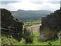
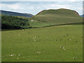
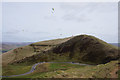
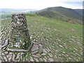
The remains of two Early Bronze Age barrows, which pre-date the defences, have been discovered on the summit of this hillfort, proving that the site must have been a focus for the local community for many years previously.
You may be viewing yesterday's version of this page. To see the most up to date information please register for a free account.
Do not use the above information on other web sites or publications without permission of the contributor.
Nearby Images from Geograph Britain and Ireland:
©2006(licence)
©2016(licence)
©2019(licence)
©2008(licence)
©2011(licence)
The above images may not be of the site on this page, they are loaded from Geograph.
Please Submit an Image of this site or go out and take one for us!
Click here to see more info for this site
Nearby sites
Key: Red: member's photo, Blue: 3rd party photo, Yellow: other image, Green: no photo - please go there and take one, Grey: site destroyed
Download sites to:
KML (Google Earth)
GPX (GPS waypoints)
CSV (Garmin/Navman)
CSV (Excel)
To unlock full downloads you need to sign up as a Contributory Member. Otherwise downloads are limited to 50 sites.
Turn off the page maps and other distractions
Nearby sites listing. In the following links * = Image available
141m NE 45° Mam Tor* Hillfort (SK128837)
1.0km ENE 73° Russet Well* Holy Well or Sacred Spring (SK137839)
1.1km SE 124° Treak Cliff Sepulchral Cave* Cave or Rock Shelter (SK136830)
1.5km W 266° The Lords Seat* Round Barrow(s) (SK112835)
2.2km ESE 111° Lady's well (Cavedale) Holy Well or Sacred Spring (SK148828)
2.5km ESE 114° Cave Dale 2* Cave or Rock Shelter (SK150826)
2.7km SSW 195° Eldon Hill 2* Round Barrow(s) (SK12028099)
2.7km SSW 205° Eldon Hill* Round Barrow(s) (SK11568114)
3.0km SW 217° Perryfoot Long Barrow (SK109812)
3.1km S 175° Ox Low* Round Barrow(s) (SK130805)
3.1km ESE 115° Dirt Low Round Barrow(s) (SK15558229)
3.9km NNE 12° Druids' Stone* Natural Stone / Erratic / Other Natural Feature (SK135874)
4.1km E 100° The Folly Round Barrow(s) (SK168829)
4.2km NNW 330° Grindsbrook Clough, Edale* Rock Art (SK106872)
4.2km SW 224° Harrod Low* Long Barrow (SK098806)
4.3km NNE 28° The Druids Altar Round Barrow(s) (SK147874)
4.3km W 262° Green Low ringcairn* Ring Cairn (SK084830)
4.5km WSW 253° Ford Hall Cairn (SK084823)
4.5km E 92° St Peter (Hope)* Ancient Cross (SK1725583445)
4.9km SE 132° Fissure Cave Cave or Rock Shelter (SK164803)
5.0km ESE 109° Bath Spring Holy Well or Sacred Spring (SK174820)
5.2km WSW 249° Mag Low* Round Barrow(s) (SK078817)
5.6km WNW 297° Edale Cross* Ancient Cross (SK0772586092)
5.6km SE 126° Hazlebadge Round Barrow 1* Round Barrow(s) (SK17268034)
5.8km SW 228° Ebbing and Flowing Well (Chapel)* Holy Well or Sacred Spring (SK08437972)
View more nearby sites and additional images


 We would like to know more about this location. Please feel free to add a brief description and any relevant information in your own language.
 Wir möchten mehr über diese Stätte erfahren. Bitte zögern Sie nicht, eine kurze Beschreibung und relevante Informationen in Deutsch hinzuzufügen.
 Nous aimerions en savoir encore un peu sur les lieux. S'il vous plaît n'hesitez pas à ajouter une courte description et tous les renseignements pertinents dans votre propre langue.
 Quisieramos informarnos un poco más de las lugares. No dude en añadir una breve descripción y otros datos relevantes en su propio idioma.