 with our Megalithic Portal iPhone app")


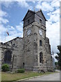
<< Our Photo Pages >> St Leonard (Rochdale) - Ancient Cross in England in Greater Manchester
Submitted by TimPrevett on Sunday, 27 May 2007 Page Views: 12832
Early MedievalSite Name: St Leonard (Rochdale)Country: England
NOTE: This site is 5.221 km away from the location you searched for.
County: Greater Manchester Type: Ancient Cross
Nearest Town: Rochdale Nearest Village: Middleton
Map Ref: SD872063
Latitude: 53.553170N Longitude: 2.194675W
Condition:
| 5 | Perfect |
| 4 | Almost Perfect |
| 3 | Reasonable but with some damage |
| 2 | Ruined but still recognisable as an ancient site |
| 1 | Pretty much destroyed, possibly visible as crop marks |
| 0 | No data. |
| -1 | Completely destroyed |
| 5 | Superb |
| 4 | Good |
| 3 | Ordinary |
| 2 | Not Good |
| 1 | Awful |
| 0 | No data. |
| 5 | Can be driven to, probably with disabled access |
| 4 | Short walk on a footpath |
| 3 | Requiring a bit more of a walk |
| 2 | A long walk |
| 1 | In the middle of nowhere, a nightmare to find |
| 0 | No data. |
| 5 | co-ordinates taken by GPS or official recorded co-ordinates |
| 4 | co-ordinates scaled from a detailed map |
| 3 | co-ordinates scaled from a bad map |
| 2 | co-ordinates of the nearest village |
| 1 | co-ordinates of the nearest town |
| 0 | no data |
Be the first person to rate this site - see the 'Contribute!' box in the right hand menu.
Internal Links:
External Links:
I have visited· I would like to visit
shepstones visited on 14th Sep 2014 - their rating: Cond: 3 Amb: 4 Access: 5 Possible Ancient Anglo Saxon cross in a recess inside the church. Shaft of the cross is in good condition and was re-discovered during restoration work in 1910.
Etched cross to be found in the same place, possibly a later carving.
Anglo Saxon material used in the construction of the current church including an arch, random stones and what is though to be the Anglo Saxon alter with three of the five crosses (symbolizing the five wounds of Jesus) stored in the side alter.
 (PID:127596)")
Anglo Saxon cross shaft built into St Leonard's, Rochdale.
You may be viewing yesterday's version of this page. To see the most up to date information please register for a free account.
 (PID:127599)")
 (PID:127598)")
 (PID:127597)")
Do not use the above information on other web sites or publications without permission of the contributor.
Nearby Images from Geograph Britain and Ireland:

©2008(licence)

©2013(licence)

©2018(licence)
©2020(licence)

©2008(licence)
The above images may not be of the site on this page, they are loaded from Geograph.
Please Submit an Image of this site or go out and take one for us!
Click here to see more info for this site
Nearby sites
Key: Red: member's photo, Blue: 3rd party photo, Yellow: other image, Green: no photo - please go there and take one, Grey: site destroyed
Download sites to:
KML (Google Earth)
GPX (GPS waypoints)
CSV (Garmin/Navman)
CSV (Excel)
To unlock full downloads you need to sign up as a Contributory Member. Otherwise downloads are limited to 50 sites.
Turn off the page maps and other distractions
Nearby sites listing. In the following links * = Image available
7.1km NNE 20° Broadfield Park Glacial Boulder* Natural Stone / Erratic / Other Natural Feature (SD896130)
7.7km NW 324° Castle Hill, Heywood Hillfort (SD827125)
8.6km NW 323° Walmersley Golf Club stone* Modern Stone Circle etc (SD82011319)
9.2km NE 46° Tunshill Tolmen* Holed Stone (SD939127)
9.5km NNW 335° Wind Hill Cheesden* Round Barrow(s) (SD8326214945)
9.6km N 355° Hunger Hill Cairn* Cairn (SD864159)
9.7km N 2° Lowe Dunishbooth Promontory Fort / Cliff Castle (SD8756115960)
9.7km N 3° Lower Dunishbooth Promontory Fort / Cliff Castle (SD8779616025)
9.8km W 261° Giant's Seat Hillfort (SD775048)
10.0km NW 311° Castlesteads (Walmersley)* Hillfort (SD797129)
10.1km SSW 195° Manchester Museum* Museum (SJ845966)
10.5km W 274° Radcliffe Hillfort (SD767070)
10.8km E 84° Delph Tumulus Round Barrow(s) (SD980074)
12.0km NW 326° Whitelow* Cairn (SD80501626)
12.0km SW 230° St Mary the Virgin (Eccles) Ancient Cross (SJ77899868)
12.1km N 356° Hamer Hill* Stone Circle (SD863184)
12.1km NE 43° Clegg Moor* Rock Art (SD955152)
12.6km ESE 112° Buckton Castle Hillfort (SD9890501634)
12.7km SSW 212° The Great Stone (Trafford)* Natural Stone / Erratic / Other Natural Feature (SJ8043395580)
12.8km S 179° Cringle Park* Modern Stone Circle etc (SJ87399347)
12.9km WNW 290° Dry Hillock Marker Stone* Marker Stone (SD7511310830)
13.3km ENE 78° Jackson's Barrow* Round Barrow(s) (SE00200905)
13.3km NW 309° Whippalow Hill* Barrow Cemetery (SD76921477)
13.7km ESE 118° Harridge Pike Cairn (SJ994999)
13.8km E 95° Pots and Pans Stone (Greenfield)* Natural Stone / Erratic / Other Natural Feature (SE0100805072)
View more nearby sites and additional images


 We would like to know more about this location. Please feel free to add a brief description and any relevant information in your own language.
 Wir möchten mehr über diese Stätte erfahren. Bitte zögern Sie nicht, eine kurze Beschreibung und relevante Informationen in Deutsch hinzuzufügen.
 Nous aimerions en savoir encore un peu sur les lieux. S'il vous plaît n'hesitez pas à ajouter une courte description et tous les renseignements pertinents dans votre propre langue.
 Quisieramos informarnos un poco más de las lugares. No dude en añadir una breve descripción y otros datos relevantes en su propio idioma.