<< Our Photo Pages >> Kendal Museum - Museum in England in Cumbria
Submitted by vicky on Saturday, 30 November 2002 Page Views: 5349
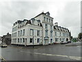
MuseumsSite Name: Kendal MuseumCountry: England
NOTE: This site is 4.861 km away from the location you searched for.
County: Cumbria Type: Museum
Nearest Town: Kendal
Map Ref: SD519931 Landranger Map Number: 97
Latitude: 54.331186N Longitude: 2.741168W
Condition:
| 5 | Perfect |
| 4 | Almost Perfect |
| 3 | Reasonable but with some damage |
| 2 | Ruined but still recognisable as an ancient site |
| 1 | Pretty much destroyed, possibly visible as crop marks |
| 0 | No data. |
| -1 | Completely destroyed |
| 5 | Superb |
| 4 | Good |
| 3 | Ordinary |
| 2 | Not Good |
| 1 | Awful |
| 0 | No data. |
| 5 | Can be driven to, probably with disabled access |
| 4 | Short walk on a footpath |
| 3 | Requiring a bit more of a walk |
| 2 | A long walk |
| 1 | In the middle of nowhere, a nightmare to find |
| 0 | No data. |
| 5 | co-ordinates taken by GPS or official recorded co-ordinates |
| 4 | co-ordinates scaled from a detailed map |
| 3 | co-ordinates scaled from a bad map |
| 2 | co-ordinates of the nearest village |
| 1 | co-ordinates of the nearest town |
| 0 | no data |
Be the first person to rate this site - see the 'Contribute!' box in the right hand menu.
Internal Links:
External Links:
I have visited· I would like to visit
FrothNinja visited - their rating: Access: 5
coin have visited here
")
Large collection including Mesolithic tools and Neolithic axe heads and stone tools from Great Langdale
Address: Station Road, LA9 6BT
Phone: 01539 721374
Opening Hours: Open Monday - Saturday (closed Sundays), 10.30am - 5.00pm (Closing 4.00pm Feb, Mar, Nov, Dec)
Admission: Charge
Website: Kendal Museum
You may be viewing yesterday's version of this page. To see the most up to date information please register for a free account.
Do not use the above information on other web sites or publications without permission of the contributor.
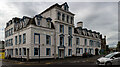
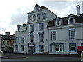
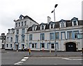
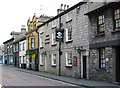
Nearby Images from Geograph Britain and Ireland:
©2021(licence)
©2016(licence)
©2018(licence)
©2011(licence)
©2023(licence)
The above images may not be of the site on this page, they are loaded from Geograph.
Please Submit an Image of this site or go out and take one for us!
Click here to see more info for this site
Nearby sites
Key: Red: member's photo, Blue: 3rd party photo, Yellow: other image, Green: no photo - please go there and take one, Grey: site destroyed
Download sites to:
KML (Google Earth)
GPX (GPS waypoints)
CSV (Garmin/Navman)
CSV (Excel)
To unlock full downloads you need to sign up as a Contributory Member. Otherwise downloads are limited to 50 sites.
Turn off the page maps and other distractions
Nearby sites listing. In the following links * = Image available
982m SSW 192° The Kendal Cross* Ancient Cross (SD5168692141)
1.3km SSW 202° Anchorite Well (Kendal)* Holy Well or Sacred Spring (SD5140691932)
4.6km SSE 164° Helm Hill* Hillfort (SD531887)
5.9km NNW 344° Potter Fell* Ring Cairn (SD503988)
6.7km SSW 200° Sizergh Fell Round Cairn 2* Round Cairn (SD4952486868)
6.7km SSW 200° Sizergh Settlement* Ancient Village or Settlement (SD49528686)
6.7km SSW 201° Sizergh Fell Round Cairn 1* Round Cairn (SD4938886886)
6.8km SSW 203° Sizergh Fell Stone Circle* Stone Circle (SD492869)
7.0km S 190° Leven's Park ringcairn* Ring Cairn (SD506862)
7.3km S 190° Levens Park ring cairn 2* Ring Cairn (SD5053385945)
9.9km SSW 193° St Mary's Well (Heversham)* Holy Well or Sacred Spring (SD4958383452)
10.0km SSW 193° St Peter's Church (Heversham)* Ancient Cross (SD4960083390)
10.0km SSW 194° Heversham Ancient Wall Misc. Earthwork (SD494834)
11.1km WNW 303° Bannerrigg Possible Standing Stone* Standing Stone (Menhir) (SD426992)
11.3km NW 313° Hughill* Ancient Village or Settlement (NY4373900980)
12.8km SSW 194° Haverbrack Fell Misc. Earthwork (SD486807)
13.2km S 169° Holme Park Fell 1* Rock Outcrop (SD5419280141)
13.2km S 190° Bela Stone Row* Stone Row / Alignment (SD495801)
13.4km SSE 169° Holme Park Fell 2* Rock Outcrop (SD5439879957)
13.5km SSW 196° Haverbrack Cairn Cairn (SD480802)
13.5km SSW 195° The Dog Hole Cave or Rock Shelter (SD482801)
13.5km SSW 196° Dog Hole possible dolmen/propped stone* Natural Stone / Erratic / Other Natural Feature (SD481801)
13.8km E 94° Old Market Cross (Sedbergh) Ancient Cross (SD657921)
14.0km S 188° The Rent Stone* Natural Stone / Erratic / Other Natural Feature (SD498792)
14.4km SSW 192° The Fairy Steps* Natural Stone / Erratic / Other Natural Feature (SD488790)
View more nearby sites and additional images


 We would like to know more about this location. Please feel free to add a brief description and any relevant information in your own language.
 Wir möchten mehr über diese Stätte erfahren. Bitte zögern Sie nicht, eine kurze Beschreibung und relevante Informationen in Deutsch hinzuzufügen.
 Nous aimerions en savoir encore un peu sur les lieux. S'il vous plaît n'hesitez pas à ajouter une courte description et tous les renseignements pertinents dans votre propre langue.
 Quisieramos informarnos un poco más de las lugares. No dude en añadir una breve descripción y otros datos relevantes en su propio idioma.