


<< Our Photo Pages >> Potter Fell - Ring Cairn in England in Cumbria
Submitted by Bladup on Wednesday, 22 May 2013 Page Views: 4066
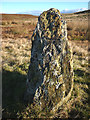
Neolithic and Bronze AgeSite Name: Potter FellCountry: England
NOTE: This site is 2.606 km away from the location you searched for.
County: Cumbria Type: Ring Cairn
Map Ref: SD503988
Latitude: 54.382255N Longitude: 2.766723W
Condition:
| 5 | Perfect |
| 4 | Almost Perfect |
| 3 | Reasonable but with some damage |
| 2 | Ruined but still recognisable as an ancient site |
| 1 | Pretty much destroyed, possibly visible as crop marks |
| 0 | No data. |
| -1 | Completely destroyed |
| 5 | Superb |
| 4 | Good |
| 3 | Ordinary |
| 2 | Not Good |
| 1 | Awful |
| 0 | No data. |
| 5 | Can be driven to, probably with disabled access |
| 4 | Short walk on a footpath |
| 3 | Requiring a bit more of a walk |
| 2 | A long walk |
| 1 | In the middle of nowhere, a nightmare to find |
| 0 | No data. |
| 5 | co-ordinates taken by GPS or official recorded co-ordinates |
| 4 | co-ordinates scaled from a detailed map |
| 3 | co-ordinates scaled from a bad map |
| 2 | co-ordinates of the nearest village |
| 1 | co-ordinates of the nearest town |
| 0 | no data |
Internal Links:
External Links:
I have visited· I would like to visit
SumDoood would like to visit
")
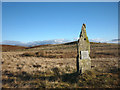
Listed in some books as a stone circle, The site has about 20 low stones in the kerb of a circle, it has very nice views.
You may be viewing yesterday's version of this page. To see the most up to date information please register for a free account.
")
Do not use the above information on other web sites or publications without permission of the contributor.
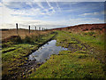
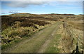
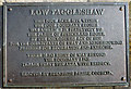
Nearby Images from Geograph Britain and Ireland:
©2016(licence)
©2010(licence)
©2012(licence)
©2012(licence)
©2012(licence)
The above images may not be of the site on this page, they are loaded from Geograph.
Please Submit an Image of this site or go out and take one for us!
Click here to see more info for this site
Nearby sites
Key: Red: member's photo, Blue: 3rd party photo, Yellow: other image, Green: no photo - please go there and take one, Grey: site destroyed
Download sites to:
KML (Google Earth)
GPX (GPS waypoints)
CSV (Garmin/Navman)
CSV (Excel)
To unlock full downloads you need to sign up as a Contributory Member. Otherwise downloads are limited to 50 sites.
Turn off the page maps and other distractions
Nearby sites listing. In the following links * = Image available
5.9km SSE 164° Kendal Museum* Museum (SD519931)
6.8km SSE 168° The Kendal Cross* Ancient Cross (SD5168692141)
6.9km WNW 288° Hughill* Ancient Village or Settlement (NY4373900980)
7.0km S 170° Anchorite Well (Kendal)* Holy Well or Sacred Spring (SD5140691932)
7.7km W 272° Bannerrigg Possible Standing Stone* Standing Stone (Menhir) (SD426992)
10.1km NE 36° Clovenstone Hill* Natural Stone / Erratic / Other Natural Feature (NY5637706859)
10.5km NNW 332° The Ull Stone Natural Stone / Erratic / Other Natural Feature (NY455081)
10.5km SSE 164° Helm Hill* Hillfort (SD531887)
11.0km NNE 19° Gray Bull* Natural Stone / Erratic / Other Natural Feature (NY5396209201)
11.1km NNE 23° To Stone or to'ther* Natural Stone / Erratic / Other Natural Feature (NY5479208955)
11.2km NW 309° Hird Wood* Stone Circle (NY41630589)
11.7km NW 319° Troutbeck Park Round Cairn 3* Round Cairn (NY4273707734)
11.7km NW 319° Troutbeck Park Round Cairn 4* Round Cairn (NY4274707790)
11.8km NW 318° Troutbeck Park Round Cairn 2* Round Cairn (NY4250707632)
11.8km NW 318° Troutbeck Park Round Cairn 1* Round Cairn (NY4248407616)
11.9km S 184° Sizergh Fell Round Cairn 1* Round Cairn (SD4938886886)
11.9km S 185° Sizergh Fell Stone Circle* Stone Circle (SD492869)
11.9km S 183° Sizergh Fell Round Cairn 2* Round Cairn (SD4952486868)
12.0km S 183° Sizergh Settlement* Ancient Village or Settlement (SD49528686)
12.6km S 178° Leven's Park ringcairn* Ring Cairn (SD5060086200)
12.8km S 178° Levens Park ring cairn 2* Ring Cairn (SD5053385945)
13.0km NNW 328° High Street Roman Road* Ancient Trackway (NY43470988)
13.1km NNE 34° Shap Wells Iron Age/Romano British Settlement Ancient Village or Settlement (NY5767309593)
13.6km WSW 257° St Helen's Well (Thorpe Hesley) Holy Well or Sacred Spring (SD370960)
13.6km NNE 22° Thorny Bank* Cairn (NY555114)
View more nearby sites and additional images


 We would like to know more about this location. Please feel free to add a brief description and any relevant information in your own language.
 Wir möchten mehr über diese Stätte erfahren. Bitte zögern Sie nicht, eine kurze Beschreibung und relevante Informationen in Deutsch hinzuzufügen.
 Nous aimerions en savoir encore un peu sur les lieux. S'il vous plaît n'hesitez pas à ajouter une courte description et tous les renseignements pertinents dans votre propre langue.
 Quisieramos informarnos un poco más de las lugares. No dude en añadir una breve descripción y otros datos relevantes en su propio idioma.