<< Text Pages >> Jabi Cup Mark Stone - Rock Art in Nigeria
Submitted by KaiHofmann on Tuesday, 24 September 2013 Page Views: 7124
Rock ArtSite Name: Jabi Cup Mark StoneCountry: Nigeria
NOTE: This site is 600.274 km away from the location you searched for.
Type: Rock Art
Nearest Town: Abuja Nearest Village: Jabi
Latitude: 9.083596N Longitude: 7.391807E
Condition:
| 5 | Perfect |
| 4 | Almost Perfect |
| 3 | Reasonable but with some damage |
| 2 | Ruined but still recognisable as an ancient site |
| 1 | Pretty much destroyed, possibly visible as crop marks |
| 0 | No data. |
| -1 | Completely destroyed |
| 5 | Superb |
| 4 | Good |
| 3 | Ordinary |
| 2 | Not Good |
| 1 | Awful |
| 0 | No data. |
| 5 | Can be driven to, probably with disabled access |
| 4 | Short walk on a footpath |
| 3 | Requiring a bit more of a walk |
| 2 | A long walk |
| 1 | In the middle of nowhere, a nightmare to find |
| 0 | No data. |
| 5 | co-ordinates taken by GPS or official recorded co-ordinates |
| 4 | co-ordinates scaled from a detailed map |
| 3 | co-ordinates scaled from a bad map |
| 2 | co-ordinates of the nearest village |
| 1 | co-ordinates of the nearest town |
| 0 | no data |
Be the first person to rate this site - see the 'Contribute!' box in the right hand menu.
Internal Links:
External Links:
Rock Art in Nigeria
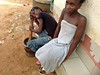
Cup marked stone near Jabi.
You may be viewing yesterday's version of this page. To see the most up to date information please register for a free account.
Do not use the above information on other web sites or publications without permission of the contributor.
Nearby Images from Flickr


The above images may not be of the site on this page, but were taken nearby. They are loaded from Flickr so please click on them for image credits.
Click here to see more info for this site
Nearby sites
Click here to view sites on an interactive map of the areaKey: Red: member's photo, Blue: 3rd party photo, Yellow: other image, Green: no photo - please go there and take one, Grey: site destroyed
Download sites to:
KML (Google Earth)
GPX (GPS waypoints)
CSV (Garmin/Navman)
CSV (Excel)
To unlock full downloads you need to sign up as a Contributory Member. Otherwise downloads are limited to 50 sites.
Turn off the page maps and other distractions
Nearby sites listing. In the following links * = Image available
11.9km N 11° Abuja Cup Mark Stone Rock Art
22.2km SSE 149° Waru Cup Mark Stone Rock Art
81.2km NE 55° Taruga* Ancient Village or Settlement
364.0km SSE 160° Ikom Monoliths* Standing Stones
869.7km N 10° Gobero Barrow Cemetery
915.2km NNE 17° Gobero Barrow Cemetery
1023.9km N 2° Air Giraffe Rock Art Rock Art
1111.5km NNE 15° Adrar Madet (Massif) Stone Circle Stone Circle
1270.3km NNW 332° Adrar des Ifoghas petroglyphs Rock Art
1300.1km SW 219° Crowders Mountain stones Natural Stone / Erratic / Other Natural Feature
1300.1km SW 219° County Guides No. 1 - Essex NOT SET
1300.1km SW 219° Mound Reveals Clues on Prehistoric People in North Carolina Artificial Mound
1300.1km SW 219° The Boyne Valley Envisioned NOT SET
1300.1km SW 219° Stonehenge Lost Property NOT SET
1300.1km SW 219° Megaliths in Brittany are in our e-Gallery NOT SET
1300.1km SW 219° County Guides No.3 - Isles of Scilly NOT SET
1300.1km SW 219° Swindon Stone Circle - Believe it. NOT SET
1300.1km SW 219° The Nine Pins – a Staffordshire mystery NOT SET
1300.1km SW 219° Live link planned to Derry school dig NOT SET
1300.1km SW 219° life-histories of megaliths NOT SET
1300.1km SW 219° Armenia - Stone Circles, Standing Stones and Petroglyphs NOT SET
1300.1km SW 219° Interview about Alasdair Whittle's new book NOT SET
1300.1km SW 219° Mortar used in restoration damaging monuments NOT SET
1300.1km SW 219° Prehistoric Music - BBC Radio 4 Frontiers NOT SET
1300.1km SW 219° Stone Circle reveals ancient secrets of rising and setting sun NOT SET
View more nearby sites and additional images


 We would like to know more about this location. Please feel free to add a brief description and any relevant information in your own language.
 Wir möchten mehr über diese Stätte erfahren. Bitte zögern Sie nicht, eine kurze Beschreibung und relevante Informationen in Deutsch hinzuzufügen.
 Nous aimerions en savoir encore un peu sur les lieux. S'il vous plaît n'hesitez pas à ajouter une courte description et tous les renseignements pertinents dans votre propre langue.
 Quisieramos informarnos un poco más de las lugares. No dude en añadir una breve descripción y otros datos relevantes en su propio idioma.