Featured: How and why the ancients enchanted Great Britain and Brittany

How and why the ancients enchanted Great Britain and Brittany

Ancestral Geographies of the Neolithic, Edmonds, Bender

Ancestral Geographies of the Neolithic, Edmonds, Bender

Who's Online

There are currently, 665 guests and 3 members online.

You are a guest. To join in, please register for free by clicking here

Sponsors

<< Our Photo Pages >> Normanton Down - Barrow Cemetery in England in Wiltshire

Submitted by Horatio on Wednesday, 24 April 2024  Page Views: 14379

Neolithic and Bronze AgeSite Name: Normanton Down
Country: England County: Wiltshire Type: Barrow Cemetery
Nearest Town: Salisbury  Nearest Village: Amesbury
Map Ref: SU118412  Landranger Map Number: 184
Latitude: 51.169922N  Longitude: 1.832604W
Condition:
5Perfect
4Almost Perfect
3Reasonable but with some damage
2Ruined but still recognisable as an ancient site
1Pretty much destroyed, possibly visible as crop marks
0No data.
-1Completely destroyed
4 Ambience:
5Superb
4Good
3Ordinary
2Not Good
1Awful
0No data.
4 Access:
5Can be driven to, probably with disabled access
4Short walk on a footpath
3Requiring a bit more of a walk
2A long walk
1In the middle of nowhere, a nightmare to find
0No data.
4 Accuracy:
5co-ordinates taken by GPS or official recorded co-ordinates
4co-ordinates scaled from a detailed map
3co-ordinates scaled from a bad map
2co-ordinates of the nearest village
1co-ordinates of the nearest town
0no data
5

Internal Links:
External Links:

I have visited· I would like to visit

whese001 would like to visit

Couplands saw from a distance on 11th Sep 2023 - their rating: Cond: 3 Amb: 3 Access: 3

Jansold visited on 24th Feb 2017 - their rating: Cond: 4 Amb: 4 Access: 4

XIII saw from a distance on 12th Aug 2015 - their rating: Amb: 3 Access: 3

DrewParsons AngieLake have visited here

Average ratings for this site from all visit loggers: Condition: 3.5 Ambience: 3.33 Access: 3.33

Normanton Down
Normanton Down submitted by Horatio : Looking west towards Normanton Gorse and also the famous Bush barrow in the distance (Vote or comment on this photo)
The bronze age barrow cemetery south of Stonehenge, the other side of the A303. Including Early Bronze Age Beaker burials and the remains of a Neolithic long barrow.

Page originally by Pete G.

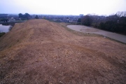
Note: Top photo: Looking west towards Normanton Gorse and also the famous Bush barrow in the distance. We have other recent photos on our other pages, browse the nearby sites list from this page
You may be viewing yesterday's version of this page. To see the most up to date information please register for a free account.


Normanton Down
Normanton Down submitted by Horatio : Showing the middle section of barrows on Normanton Down, (2 comments - Vote or comment on this photo)

Normanton Down
Normanton Down submitted by Horatio : First trip to my second home (Stonehenge landscape) of the year and great to be back! In this view I have captured the eastern end of the ridge that this cemetery lies along, the reason mainly being that it was blowing a hooley and I was crazy to fly in this wind as it was let alone to fly high enough to capture all of it, so I did it in two sections to avoid any disasters with a very small and... (Vote or comment on this photo)

Stonehenge from Normanton Down
Stonehenge from Normanton Down submitted by Camille1992 : Stonehenge from Normanton Down Barrow Cemetery (Vote or comment on this photo)

Normanton Down Bronze Age Barrow Cemetery
Normanton Down Bronze Age Barrow Cemetery submitted by Camille1992 : Normanton Down Bronze Age Barrow Cemetery (Vote or comment on this photo)

Normanton Down Long Barrow
Normanton Down Long Barrow submitted by dooclay : Looking back to the Barrow from the south

Normanton Down Long Barrow
Normanton Down Long Barrow submitted by dooclay : Looking South to the Longbarrow

Normanton Down
Normanton Down submitted by Antonine : From A303, 2009

Normanton Down
Normanton Down submitted by Antonine

Normanton Down
Normanton Down submitted by Antonine : 2014

Normanton Down
Normanton Down submitted by DrewParsons : The barrow cemetery photographed from the earth lane which bisects the site. April 2015 (1 comment)

Normanton Down
Normanton Down submitted by DrewParsons : Distant barrow to the east of the main site. April 2015

Normanton Down
Normanton Down submitted by DrewParsons : The barrow cemetery photographed from the earth lane which bisects the site. April 2015

Normanton Down
Normanton Down submitted by DrewParsons

Normanton Down
Normanton Down submitted by DrewParsons

Normanton Down
Normanton Down submitted by DrewParsons : Bush Barrow seen from the earth track which runs just to the west of the barrow. April 2015

Normanton Down
Normanton Down submitted by h_fenton : Part of Normanton Down Barrow Cemetery. The barrow with the small tree on close to the centre of the photograph is the famous Bush Barrow. Kite Aerial Photograph 2 June 2013

Normanton Down
Normanton Down submitted by h_fenton : Part of Normanton Down Barrow Cemetery. Kite Aerial Photograph 2 June 2013

Normanton Down
Normanton Down submitted by durhamnature : Gold bead from one of the barrows, from "Early Man in Britain" via archive.org

Normanton Down
Normanton Down submitted by AngieLake : Stonehenge in the distance, viewed from near the chain of barrows running E-W, and the last part of the track heading approx N towards the A303. (3 comments)

Normanton Down
Normanton Down submitted by AngieLake : Stonehenge in the distance during the walk on the permitted pathway from Coneybury Hill and Normanton Down to Stonehenge.

Normanton Down
Normanton Down submitted by AngieLake : Stonehenge from Normanton Down, just near the junction of the very busy A303. With the large round barrow to SW of Stonehenge behind me, this view to NE lines up with the 'spine' of Stone 16 in the SW arc of the sarsen circle.

Normanton Down
Normanton Down submitted by AngieLake : Nearly at the junction of the permitted pathway over Normanton Down with the A303, and looking back to the large round barrow to due SW of Stonehenge. (This is the one that I'm sure the Winter Solstice sun sets over.) Looking in the other direction it lines up nicely with the 'spine' of the outer face of Stone 16 in the SW arc of Stonehenge's outer sarsen ring.

Normanton Down
Normanton Down submitted by AngieLake : The Normanton Down barrow that is due SW of Stonehenge, looms on the ridge to your left as you head north towards the A303.

Normanton Down
Normanton Down submitted by AngieLake : A zoom in to the southern side of the one I thought was Bush Barrow, to the east of that chain.

These are just the first 25 photos of Normanton Down. If you log in with a free user account you will be able to see our entire collection.

Do not use the above information on other web sites or publications without permission of the contributor.
Click here to see more info for this site

Nearby sites

Click here to view sites on an interactive OS map

Key: Red: member's photo, Blue: 3rd party photo, Yellow: other image, Green: no photo - please go there and take one, Grey: site destroyed

Download sites to:
KML (Google Earth)
GPX (GPS waypoints)
CSV (Garmin/Navman)
CSV (Excel)

To unlock full downloads you need to sign up as a Contributory Member. Otherwise downloads are limited to 50 sites.


Turn off the page maps and other distractions

Nearby sites listing. In the following links * = Image available
 170m WNW 291° Bush Barrow* Round Barrow(s) (SU11644126)
 407m WSW 252° Normanton Down Long Barrow* Long Barrow (SU1141341071)
 610m NNW 335° North of Normanton Gorse Barrows* Barrow Cemetery (SU1154441754)
 973m WNW 287° Pond Barrow and Wilsford Shaft Round Barrow(s) (SU1086441475)
 1.1km NNE 24° Stonehenge.* Stone Circle (SU1224742194)
 1.2km NNE 33° Stonehenge Bowl Barrow* Round Barrow(s) (SU12424217)
 1.2km NNE 25° Heel Stone* Standing Stone (Menhir) (SU1229142244)
 1.2km N 10° Stonehenge Car Park Postholes* Timber Circle (SU120424)
 1.3km SW 222° Lake Barrow Cemetery* Barrow Cemetery (SU109402)
 1.4km S 180° Wilsford Barrow Cemetery Barrow Cemetery (SU118398)
 1.5km NNW 347° Bowl and Bell Barrow* Barrow Cemetery (SU11454270)
 1.6km N 3° Great Cursus Barrows, Stonehenge* Round Barrow(s) (SU11894278)
 1.6km ENE 58° Amesbury 39 Bowl Barrow* Round Barrow(s) (SU13154204)
 1.6km ENE 76° Coneybury Henge* Henge (SU134416)
 1.7km NNE 32° The Avenue* Ancient Trackway (SU12694262)
 1.7km NNW 337° Fargo Disk Barrow* Round Barrow(s) (SU11154275)
 1.7km WNW 288° Winterbourne Stoke* Barrow Cemetery (SU10174171)
 1.8km E 85° King Barrow (Amesbury)* Barrow Cemetery (SU13554137)
 1.8km W 280° Long Barrow Cross* Ancient Cross (SU1005441499)
 1.8km N 9° Great Cursus, Stonehenge* Cursus (SU12064296)
 1.9km S 183° Lake Down Barrow Cemetery Barrow Cemetery (SU117393)
 1.9km NNW 332° Amesbury Cursus (W)* Cursus (SU109429)
 1.9km NNE 17° Great Cursus W Barrow* Round Barrow(s) (SU1235143043)
 1.9km ENE 58° New King Barrows* Barrow Cemetery (SU13454222)
 2.1km NW 304° North of Winterbourne Stoke Crossroads* Barrow Cemetery (SU1004742378)
View more nearby sites and additional images

<< Nalanda University excavated site

Pozzo di Piazzalunga >>

Please add your thoughts on this site

Prehistoric Avebury

Prehistoric Avebury

Sponsors

Auto-Translation (Google)

Translate from English into:

"Normanton Down" | Login/Create an Account | 4 News and Comments
  
Go back to top of page    Comments are owned by the poster. We aren't responsible for their content.
Stonehenge and Avebury seminar at Devizes, May 2010 by Andy B on Monday, 21 June 2010
(User Info | Send a Message)
Stuart Needham talked on “A complex of cemeteries”, relating BA barrow distribution to the earlier monuments. He believes that there is a compelling case for continuing reverence of a “super-sacred” zone around Stonehenge, and of Stonehenge itself; he cites the evidence of the axe carvings and the digging of the Y/Z holes, while the adjacent cemeteries, like Normanton Down, show “barrow intensification”, with selected individuals being chosen for burial in these special zones. He made some interesting points about the Y/Z holes, suggesting that at least one of the holes seems to have held a stone orthostat, while the pattern of the rings seems to have encouraged a spiralling perambulation, with the point of entry being near the henge’s southern entrance.

Needham went on to suggest that, while the sacred use of Stonehenge continued into the BA, the map of sacredness was more distributed into the surrounding landscape. The Normanton Down cemeteries complex straddles the NE/SW solstitial line. Could it be, he wonders, that there are the remains of less substantial structures still to be found on the line? And it’s defined by the two dry valleys extending from Lake, to the south, while there’s similar dry valley access from the river Till to the Coniger and Winterbourne Stoke cemeteries. He believes that archaeologists “need to take river valleys more seriously.”

More at
http://www.eternalidol.com/?p=7267
[ Reply to This ]

Normanton Down Street View by SteveDut on Thursday, 01 April 2010
(User Info | Send a Message)

View Larger Map
[ Reply to This ]

Re: Normanton Down by coldrum on Monday, 10 August 2009
(User Info | Send a Message)
Pastscape entry:

http://www.pastscape.org.uk/hob.aspx?hob_id=943053
[ Reply to This ]

Re: Normanton Down by Anonymous on Monday, 25 June 2007
I have not personally been to this spot on the globe, (though I have visited the UK) but I am researching it currently to vote for Stonehenge as a part of the Modern Seven Wonders of the World vote, the first so-called "global vote," and would appreciate any information regarding this entire archaeological phenomenon. I have a few books that detail various raised grounds and megalithic structures, etc...

I will check back to see if anyone has responded to this post within the next week.
[ Reply to This ]

Your Name: Anonymous [ Register Now ]
Subject:


Add your comment or contribution to this page. Spam or offensive posts are deleted immediately, don't even bother

<<< What is five plus one as a number? (Please type the answer to this question in the little box on the left)
You can also embed videos and other things. For Youtube please copy and paste the 'embed code'.
For Google Street View please include Street View in the text.
Create a web link like this: <a href="https://www.megalithic.co.uk">This is a link</a>  

Allowed HTML is:
<p> <b> <i> <a> <img> <em> <br> <strong> <blockquote> <tt> <li> <ol> <ul> <object> <param> <embed> <iframe>

We would like to know more about this location. Please feel free to add a brief description and any relevant information in your own language.
Wir möchten mehr über diese Stätte erfahren. Bitte zögern Sie nicht, eine kurze Beschreibung und relevante Informationen in Deutsch hinzuzufügen.
Nous aimerions en savoir encore un peu sur les lieux. S'il vous plaît n'hesitez pas à ajouter une courte description et tous les renseignements pertinents dans votre propre langue.
Quisieramos informarnos un poco más de las lugares. No dude en añadir una breve descripción y otros datos relevantes en su propio idioma.