

<< Our Photo Pages >> Yacimiento Arqueológico La Bastida - Ancient Village or Settlement in Spain in Murcia
Submitted by Maatje on Thursday, 18 April 2024 Page Views: 1365
Multi-periodSite Name: Yacimiento Arqueológico La BastidaCountry: Spain Region: Murcia Type: Ancient Village or Settlement
Nearest Town: Murcia Nearest Village: Totana
Latitude: 37.762225N Longitude: 1.561584W
Condition:
| 5 | Perfect |
| 4 | Almost Perfect |
| 3 | Reasonable but with some damage |
| 2 | Ruined but still recognisable as an ancient site |
| 1 | Pretty much destroyed, possibly visible as crop marks |
| 0 | No data. |
| -1 | Completely destroyed |
| 5 | Superb |
| 4 | Good |
| 3 | Ordinary |
| 2 | Not Good |
| 1 | Awful |
| 0 | No data. |
| 5 | Can be driven to, probably with disabled access |
| 4 | Short walk on a footpath |
| 3 | Requiring a bit more of a walk |
| 2 | A long walk |
| 1 | In the middle of nowhere, a nightmare to find |
| 0 | No data. |
| 5 | co-ordinates taken by GPS or official recorded co-ordinates |
| 4 | co-ordinates scaled from a detailed map |
| 3 | co-ordinates scaled from a bad map |
| 2 | co-ordinates of the nearest village |
| 1 | co-ordinates of the nearest town |
| 0 | no data |
Internal Links:
External Links:
I have visited· I would like to visit
Maatje visited on 17th Mar 2024 - their rating: Cond: 4 Amb: 4 Access: 4 La Bastida is dated 2200 - 1550 BC.
This site can be visited with a guide during the weekend. It is signposted from Totana. More information is on the website.
It is a very remote site high upon a hill, at the steep borders of a canyon river.
It was discovered in the end of the 1869.
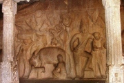
La Bastida is a Bronzeage city of the Al Algar Culture that conquers cities as Knossos and Mykonos. Archeologists are still excavating the hill and probebly is was completely inhabited.
The defence walls are thick and high.
The work, which continues today, shows an authentic city of some 40,000 m2 which, at its peak, some 3,800 years ago, was inhabited by some 1,000 people. At that time, it was one of the largest settlements in Europe and the western Mediterranean.
Dozens of dwellings have been found, terraced in artificial terraces along the slopes of the hill. The enclave itself is situated in a strategic location, hidden from the Guadalentín valley and with good natural conditions for defence.
The tombs are of particular interest, as they are located under the floor of the dwellings. They usually contained one or, sometimes, two individuals in a shrunken position, inside ceramic vessels or cists, i.e. boxes made of stone slabs or walls. Some of these tombs also contained offerings, such as ceramic bowls and pots, weapons, tools and ornaments of copper or silver, and necklaces of bone, shell and stone beads. The differences between these offerings tell us of a community divided into social classes.
It was an overwhelming archeological site.
")
At that time, it was one of the largest settlements in Europe and the western Mediterranean. Dozens of dwellings have been found, terraced in artificial terraces along the slopes of the hill. The enclave itself is situated in a strategic location, hidden from the Guadalentín valley and with good natural conditions for defence.
The tombs are of particular interest, as they are located under the floor of the dwellings. They usually contained one or, sometimes, two individuals in a shrunken position, inside ceramic vessels or cists, i.e. boxes made of stone slabs or walls. Some of these tombs also contained offerings, such as ceramic bowls and pots, weapons, tools and ornaments of copper or silver, and necklaces of bone, shell and stone beads. The differences between these offerings tell us of a community divided into social classes. It was an overwhelming archaeological site.
This site can be visited with a guide during the weekend. It is signposted from Totana. More information is on their website.
Page originally by Holger Rix.
You may be viewing yesterday's version of this page. To see the most up to date information please register for a free account.
")
")
")
")
")
")
Do not use the above information on other web sites or publications without permission of the contributor.
Click here to see more info for this site
Nearby sites
Click here to view sites on an interactive map of the areaKey: Red: member's photo, Blue: 3rd party photo, Yellow: other image, Green: no photo - please go there and take one, Grey: site destroyed
Download sites to:
KML (Google Earth)
GPX (GPS waypoints)
CSV (Garmin/Navman)
CSV (Excel)
To unlock full downloads you need to sign up as a Contributory Member. Otherwise downloads are limited to 50 sites.
Turn off the page maps and other distractions
Nearby sites listing. In the following links * = Image available
5.9km ENE 66° Totana* Ancient Village or Settlement
13.4km WSW 237° Menhir La Tercia Standing Stone (Menhir)
21.7km NNE 13° Alto de Almoloya* Castro or Chafurdão
30.8km SE 132° Sepulcro Neolítico de Cabezo del Plomo Barrow Cemetery
30.9km SE 132° Cabezo del Plomo Chambered Cairn
41.5km NW 315° Cueva Negra* Natural Stone / Erratic / Other Natural Feature
47.6km W 280° La Cueva de Ambrosio* Cave or Rock Shelter
48.0km WSW 259° Cueva de los Letreros* Cave or Rock Shelter
69.3km NW 320° Dolmen de Bagil* Burial Chamber or Dolmen
69.4km NW 320° Yacimiento Prehistórico de Bagil Ancient Village or Settlement
84.3km N 352° El Canajo Castro or Chafurdão
85.3km NE 49° Els Pontets Aqueduct* Ancient Mine, Quarry or other Industry
85.7km NE 48° Peña Negra* Ancient Village or Settlement
86.6km W 269° Necropolis de Tutugui* Ancient Village or Settlement
88.3km ENE 64° La Fonteta* Ancient Village or Settlement
92.7km NE 55° L'Alcúdia* Ancient Village or Settlement
94.3km NNW 347° Minetada Caves* Cave or Rock Shelter
98.7km NNE 20° Abrigo del Canto de la Visera* Cave or Rock Shelter
101.6km NNE 33° Cerro de los Moros Castro or Chafurdão
102.4km NNE 22° Tobanilla Castro or Chafurdão
106.1km NNE 13° Petroglifos del Arabilejo Rock Art
106.1km NNE 13° Las Cazoletas del Arabilejo Ancient Village or Settlement
106.8km WSW 255° Cerro Cepero Ancient Village or Settlement
107.1km NNE 13° Cantos de la Visera Rock Art
107.3km NNE 13° La Cueva Horadada* Cave or Rock Shelter
View more nearby sites and additional images


 We would like to know more about this location. Please feel free to add a brief description and any relevant information in your own language.
 Wir möchten mehr über diese Stätte erfahren. Bitte zögern Sie nicht, eine kurze Beschreibung und relevante Informationen in Deutsch hinzuzufügen.
 Nous aimerions en savoir encore un peu sur les lieux. S'il vous plaît n'hesitez pas à ajouter une courte description et tous les renseignements pertinents dans votre propre langue.
 Quisieramos informarnos un poco más de las lugares. No dude en añadir una breve descripción y otros datos relevantes en su propio idioma.