<< Our Photo Pages >> Glenvoidean - Chambered Cairn in Scotland in Isle of Bute
Submitted by saille on Friday, 26 March 2004 Page Views: 5385
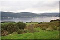
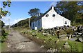
Neolithic and Bronze AgeSite Name: GlenvoideanCountry: Scotland County: Isle of Bute Type: Chambered Cairn
Nearest Town: Rothersay Nearest Village: Tignabruaich
Map Ref: NR9970870570 Landranger Map Number: 62
Latitude: 55.886496N Longitude: 5.204184W
Condition:
| 5 | Perfect |
| 4 | Almost Perfect |
| 3 | Reasonable but with some damage |
| 2 | Ruined but still recognisable as an ancient site |
| 1 | Pretty much destroyed, possibly visible as crop marks |
| 0 | No data. |
| -1 | Completely destroyed |
| 5 | Superb |
| 4 | Good |
| 3 | Ordinary |
| 2 | Not Good |
| 1 | Awful |
| 0 | No data. |
| 5 | Can be driven to, probably with disabled access |
| 4 | Short walk on a footpath |
| 3 | Requiring a bit more of a walk |
| 2 | A long walk |
| 1 | In the middle of nowhere, a nightmare to find |
| 0 | No data. |
| 5 | co-ordinates taken by GPS or official recorded co-ordinates |
| 4 | co-ordinates scaled from a detailed map |
| 3 | co-ordinates scaled from a bad map |
| 2 | co-ordinates of the nearest village |
| 1 | co-ordinates of the nearest town |
| 0 | no data |
Internal Links:
External Links:
")
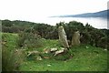
The capstone of this chambered tomb is now on the ground just like the Kilmichael Cairn, although the cap stone has only been removed for the last 4 years. Also looking at other pictures I have of this Cairn, I noticed strange markings that look man-made and could be Ogham, so I need to go back and have another look. If you look on the right stone at the top there is a crack which looks like an X - it looks too perfect to be a crack but you never know.
Canmore site no. 39897
You may be viewing yesterday's version of this page. To see the most up to date information please register for a free account.
Do not use the above information on other web sites or publications without permission of the contributor.
Nearby Images from Geograph Britain and Ireland:
©2007(licence)
©2007(licence)
©2011(licence)
©2017(licence)
©2018(licence)
The above images may not be of the site on this page, they are loaded from Geograph.
Please Submit an Image of this site or go out and take one for us!
Click here to see more info for this site
Nearby sites
Key: Red: member's photo, Blue: 3rd party photo, Yellow: other image, Green: no photo - please go there and take one, Grey: site destroyed
Download sites to:
KML (Google Earth)
GPX (GPS waypoints)
CSV (Garmin/Navman)
CSV (Excel)
To unlock full downloads you need to sign up as a Contributory Member. Otherwise downloads are limited to 50 sites.
Turn off the page maps and other distractions
Nearby sites listing. In the following links * = Image available
349m SW 220° St Michael's Grave* Chambered Cairn (NR9947070314)
747m NNW 339° Aultmore Burn Fort* Hillfort (NR9946871279)
1.6km SE 141° Carnbaan* Chambered Cairn (NS0063269316)
2.5km SSE 153° Glecknabae* Chambered Cairn (NS0074568263)
2.7km WNW 285° Kames* Standing Stones (NR97177137)
4.8km WSW 239° Colachla* Stone Fort or Dun (NR95456832)
5.2km NNE 22° Eilean Buidhe* Stone Fort or Dun (NS01867532)
5.8km ESE 122° St Colmac's Cross Standing Stone (Menhir) (NS0452167263)
6.0km SE 126° St Colmac Cottages Stone Circle* Stone Circle (NS044668)
6.2km S 183° Ardlamont Point* Rock Art (NR99146439)
6.2km ESE 121° Colmac Bridge* Standing Stone (Menhir) (NS0491367160)
6.3km SE 134° St Colmac's A Stone Circle (NS040660)
6.8km ESE 119° Acholter* Standing Stone (Menhir) (NS0546466961)
6.8km WSW 243° Creag Loisgte* Standing Stone (Menhir) (NR93506779)
6.9km WSW 249° Cnoc Pollphail* Standing Stones (NR93166835)
7.0km WSW 246° Low Stillaig* Rock Art (NR93146798)
7.1km WSW 242° Port Leathan* Cairn (NR93226754)
7.5km SSE 146° Castle Cree* Hillfort (NS0356464133)
8.0km ESE 122° Dun Burgidale* Stone Fort or Dun (NS0627766051)
8.3km WNW 282° Ardmarnock* Chambered Cairn (NR91647265)
8.3km WNW 292° Ardmarnoch 4* Rock Art (NR921740)
8.4km WNW 291° Ardmarnoch 3 Rock Art (NR91987401)
8.4km WNW 292° Auchalick Wood* Hillfort (NR92007407)
9.1km WNW 302° Inveryne Rock Art* Rock Art (NR92177578)
9.2km WNW 296° Inveryne Stone Row* Stone Row / Alignment (NR9157374974)
View more nearby sites and additional images


 We would like to know more about this location. Please feel free to add a brief description and any relevant information in your own language.
 Wir möchten mehr über diese Stätte erfahren. Bitte zögern Sie nicht, eine kurze Beschreibung und relevante Informationen in Deutsch hinzuzufügen.
 Nous aimerions en savoir encore un peu sur les lieux. S'il vous plaît n'hesitez pas à ajouter une courte description et tous les renseignements pertinents dans votre propre langue.
 Quisieramos informarnos un poco más de las lugares. No dude en añadir una breve descripción y otros datos relevantes en su propio idioma.