Contributory members are able to log private notes and comments about each site
Sites AngieLake has logged. View this log as a table or view the most recent logs from everyone
Cork Stone
Date Added: 26th Sep 2010
Site Type: Natural Stone / Erratic / Other Natural Feature
Country: England (Derbyshire)
Visited: Yes on 30th Oct 2004
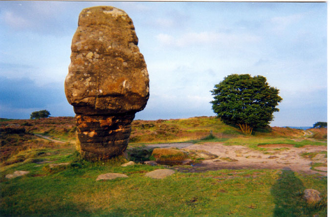
Cork Stone submitted by AngieLake on 30th Oct 2004. This is a pic of the Cork Stone at Stanton Moor in Derbyshire, taken about 8pm one August evening in 2002.
(View photo, vote or add a comment)
Log Text: None
Nine Stones Close
Date Added: 26th Sep 2010
Site Type: Stone Circle
Country: England (Derbyshire)
Visited: Yes on 15th May 2005

Nine Stones Close submitted by AngieLake on 15th May 2005. Looking northwest, this view shows the weathering on the SE stone (foreground), with the smooth inner-facing side of the cup-marked NW stone across the circle (background).
(View photo, vote or add a comment)
Log Text: None
Robin Hood's Stride
Date Added: 26th Sep 2010
Site Type: Rock Outcrop
Country: England (Derbyshire)
Visited: Yes on 22nd May 2005

Robin Hood's Stride submitted by AngieLake on 22nd May 2005. This stone caught my eye as I was climbing the east side of the hill towards Robin Hood's stride. (Following the footpath uphill, after parking in a slight layby beside the north/south road (Alport to Elton?) between Stanton Moor and Robin Hood's Stride.) The stone is well to the left of the path, over halfway up the hill. It looks as if it may have been used as a gatepost at some time.
(View photo, vote or add a comment)
Log Text: None
Robin Hood's Stride
Date Added: 26th Sep 2010
Site Type: Rock Art
Country: England (Derbyshire)
Visited: Yes on 22nd May 2005

Robin Hood's Stride submitted by AngieLake on 22nd May 2005. This stone caught my eye as I was climbing the east side of the hill towards Robin Hood's stride. (Following the footpath uphill, after parking in a slight layby beside the north/south road (Alport to Elton?) between Stanton Moor and Robin Hood's Stride.) The stone is well to the left of the path, over halfway up the hill. It looks as if it may have been used as a gatepost at some time.
(View photo, vote or add a comment)
Log Text: None
Coffin Well
Date Added: 26th Sep 2010
Site Type: Holy Well or Sacred Spring
Country: England (Derbyshire)
Visited: Yes on 12th Feb 2007

Coffin Well submitted by AngieLake on 12th Feb 2007. The Coffin Well at Tissington in 2003.
(View photo, vote or add a comment)
Log Text: None
Gib Hill
Date Added: 26th Sep 2010
Site Type: Long Barrow
Country: England (Derbyshire)
Visited: Yes on 28th Dec 2007

Gib Hill submitted by AngieLake on 28th Dec 2007. The site notice board at Gib Hill, with artist's impression of the 'tomb of the ancestors'. [New since my last visit.] Taken on 16 Dec 07.
(View photo, vote or add a comment)
Log Text: None
Arbor Low Earthwork
Date Added: 26th Sep 2010
Site Type: Multiple Stone Rows / Avenue
Country: England (Derbyshire)
Visited: Yes on 28th Dec 2007

Arbor Low Earthwork submitted by AngieLake on 28th Dec 2007. This stone stands virtually alone in the large field surrounding Gib Hill. Here (freezing cold 16 Dec 07) Arbor Low henge lies at about 60-65 degs from the stone... possible to see Summer Solstice sun rising over the banks from this position, I guess??
Gib Hill is due south.
(View photo, vote or add a comment)
Log Text: None
Arbor Low 1
Date Added: 26th Sep 2010
Site Type: Stone Circle
Country: England (Derbyshire)
Visited: Yes on 28th Dec 2007
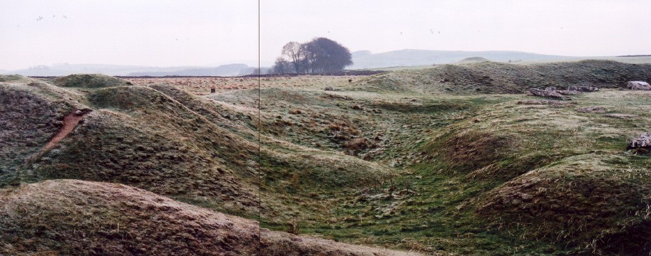
Arbor Low 1 submitted by AngieLake on 28th Dec 2007. If you can overlook the join in this compilation shot taken on a freezing afternoon of 16 Dec 07, you will see the southern causeway entrance to Arbor Low [above centre], the bumpy turmoil of the added barrow on the SE bank [left], the ditch [below], the raised central area of henge [right], and Gib Hill peeking over the distant bank [above the line of the causeway]. To the extreme right, against the darker furthest bank, the frosty form of one of the larger recumbent stones at the approx SW of...
(View photo, vote or add a comment)
Log Text: None
Bakewell Churchyard
Date Added: 26th Sep 2010
Site Type: Ancient Cross
Country: England (Derbyshire)
Visited: Yes on 3rd Nov 2009
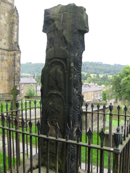
Bakewell Churchyard submitted by AngieLake on 3rd Nov 2009. Back view of the cross at Bakewell Church.
(View photo, vote or add a comment)
Log Text: None
Nine Ladies
Date Added: 26th Sep 2010
Site Type: Stone Circle
Country: England (Derbyshire)
Visited: Yes on 3rd Nov 2009
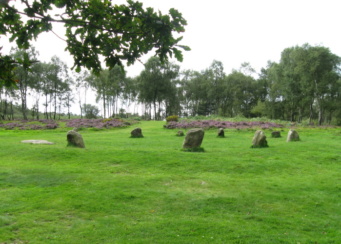
Nine Ladies submitted by AngieLake on 3rd Nov 2009. Another view of the Nine Ladies, looking towards the King Stone outlier.
(View photo, vote or add a comment)
Log Text: None
Stanton Moor 3
Date Added: 26th Sep 2010
Site Type: Stone Circle
Country: England (Derbyshire)
Visited: Yes on 25th Nov 2009
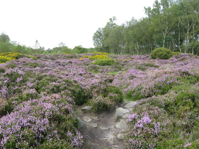
Stanton Moor 3 submitted by AngieLake on 25th Nov 2009. I'm pretty sure I've got the right cairn circle here...! Photographed in late August 09.
[Had visited a few years ago, when not quite so overgrown.]
(View photo, vote or add a comment)
Log Text: None
Andle Stone (Stanton Moor)
Date Added: 26th Sep 2010
Site Type: Natural Stone / Erratic / Other Natural Feature
Country: England (Derbyshire)
Visited: Yes on 25th Nov 2009
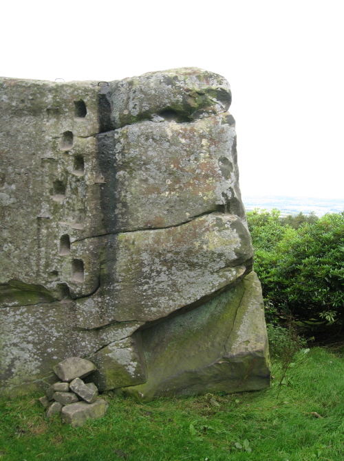
Andle Stone (Stanton Moor) submitted by AngieLake on 25th Nov 2009. The Andle Stone is like a modern-art sculpture.
(View photo, vote or add a comment)
Log Text: None
The Longstone (Shovel Down)
Date Added: 26th Sep 2010
Site Type: Standing Stone (Menhir)
Country: England (Devon)
Visited: Yes on 14th Sep 2004
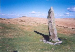
The Longstone (Shovel Down) submitted by AngieLake on 14th Sep 2004. This lovely megalith is known as The Longstone and stands on the eastern slopes of Shovel Down at SX660857. A north/south avenue leads directly to it. Kes Tor, seen in the background, is NE of the Longstone. There are numerous stone rows in the vicinity, and Scorhill circle is not far away to the northeast.
According to Richard Cavendish's book 'Prehistoric England' (Artus Books, Orion Publishing 1983):
"SW of Kes Tor, on Shovel Down, SX660860, are stone rows leading to burial cairns and a 10...
(View photo, vote or add a comment)
Log Text: None
Scorhill
Date Added: 26th Sep 2010
Site Type: Stone Circle
Country: England (Devon)
Visited: Yes on 14th Sep 2004
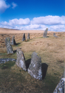
Scorhill submitted by AngieLake on 14th Sep 2004. The southwest arc of Scorhill circle
(View photo, vote or add a comment)
Log Text: None
Merrivale Centre Row
Date Added: 26th Sep 2010
Site Type: Multiple Stone Rows / Avenue
Country: England (Devon)
Visited: Yes on 12th Oct 2004
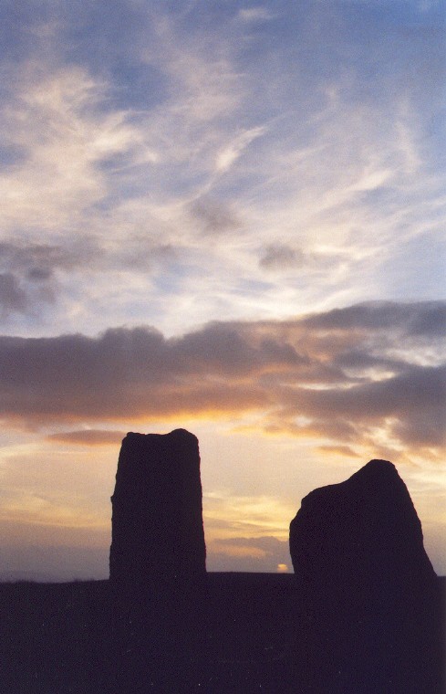
Merrivale Centre Row submitted by AngieLake on 12th Oct 2004. The Autumn Equinox sunset viewed from between the two stones at the westernmost end of the southern row at Merrivale. This was sometime after 7.00pm on 21st September 2004, a day before the official Autumn Equinox.
(View photo, vote or add a comment)
Log Text: None
Merrivale Menhir
Date Added: 26th Sep 2010
Site Type: Standing Stone (Menhir)
Country: England (Devon)
Visited: Yes on 12th Oct 2004
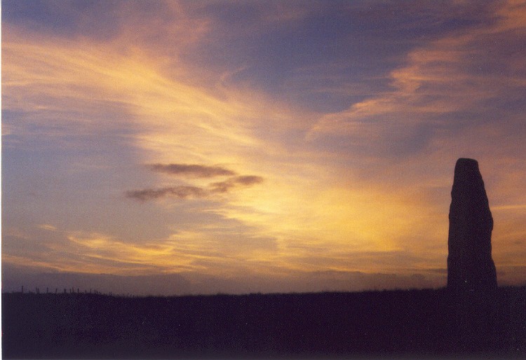
Merrivale Menhir submitted by AngieLake on 12th Oct 2004. Merrivale on the day before the official autumnal equinox last month. This is the tall standing stone that stands near the circle in the SW of the Merrivale complex. The sun had just set, I would say this was approximately 7.30pm.
(View photo, vote or add a comment)
Log Text: None
Trowlesworthy
Date Added: 26th Sep 2010
Site Type: Barrow Cemetery
Country: England (Devon)
Visited: Yes on 14th Oct 2004

Ringmoor Down stone circle submitted by AngieLake on 14th Oct 2004. This stone - looking like an electric iron, poised for use, is almost opposite the other unusual stone in Ernar's Trowlesworthy circle. It does make you think that these were especially chosen for their shapes, and begs the questions, "Why?", and, "Were they in this actual position for a reason?""
(View photo, vote or add a comment)
Log Text: None
The Round Pound
Date Added: 26th Sep 2010
Site Type: Ancient Village or Settlement
Country: England (Devon)
Visited: Yes on 24th Oct 2004
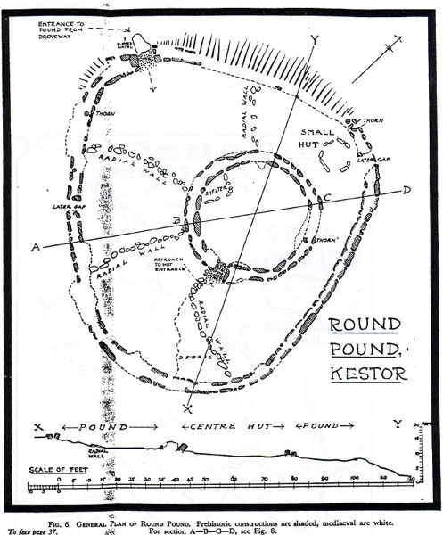
The Round Pound submitted by AngieLake on 24th Oct 2004. This shows the layout of the Round Pound at Kestor. Underneath, the caption reads: 'Fig.6. General Plan of Round Pound. Prehistoric constructions are shaded, mediaeval are white.' Therefore, it would appear that the four 'radial walls' and the 'small hut' in the outer circle, and the semi-circular 'shelter' in the inner circle, are mediaeval. This leaves the double-walled inner and outer circles to be interpreted as 'prehistoric'. The writing at very top of plan says: "Entrance to pou...
(View photo, vote or add a comment)
Log Text: None
Kestor Settlement
Date Added: 26th Sep 2010
Site Type: Ancient Village or Settlement
Country: England (Devon)
Visited: Yes on 24th Oct 2004
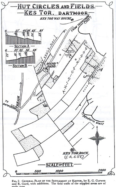
Kestor Settlement submitted by AngieLake on 24th Oct 2004. This old plan of Kes Tor hut circles and fields, includes the Round Pound. It appears that the line of parallel stones that theCaptain queried could be an old drove way. (Here referred to as 'Lower Drove Way'). In very small letters halfway up the right side of the plan, near the letter 'A', is 'Upper Drove Way'. The small print at the bottom of pic says: "Fig 2. General Plan of the Settlement at Kestor, by E.C.Curwen and R.Gurd, with additions. The field walls of the stippled areas are of...
(View photo, vote or add a comment)
Log Text: None
Shovel Down row 2
Date Added: 26th Sep 2010
Site Type: Multiple Stone Rows / Avenue
Country: England (Devon)
Visited: Yes on 27th Oct 2004

Shovel Down row 2 submitted by AngieLake on 27th Oct 2004. Looking in the opposite direction from Simcon's picture, the fallen portals are in the foreground of this photo and show the avenue leading up to them, and to the concentric circle or cairn.
(Taken on cheap single-use camera, as were the recent Scorhill postings)
(View photo, vote or add a comment)
Log Text: None
