Contributory members are able to log private notes and comments about each site
Sites Anne T has logged on trip number: 55 (View all trips)
View this log as a table or view the most recent logs from everyone
Sourhope Hillfort
Trip No.55 Entry No.1 Date Added: 12th Oct 2017
Site Type: Hillfort
Country: Scotland (Scottish Borders)
Visited: Yes on 8th Oct 2017. My rating: Condition 2 Ambience 4 Access 3

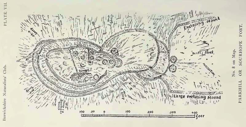
Sourhope Hillfort submitted by durhamnature on 5th Sep 2012. Drawing of the hillfort, 1897, from Berwickshire Naturalists via archive.org
Site in Scottish Borders Scotland
(View photo, vote or add a comment)
Log Text: Sourhope Hillfort, Scottish Borders: Well, this morning was a surprise, as rain had been forecast, but we woke up to a blue and cloudy sky, with little wind, so we decided to make the most of the nice weather before the clocks go back at the end of the month.
We used an ‘unusual’ (twisty/windy) route to reach this site. We drove up using the A68 past Carter’s Bar, then taking the first turning right and following the minor roads up through Hownam towards Yetholm, turning right and heading back down south at Primsidemill.
We followed the Bowmont Water Valley along to where the Sourhope Burn joins it, then headed north east up the dead end road to Sourhope Farm. Just past the cattle grid by the barns to the south west end of SouthopeFarm, there is room to park the car on the verge. We then headed up past the farm, turning right and going through two gates by a barn at NT 84596 20177, then following the path uphill towards Park Law Fort, then turning south west at NT 85047 19886 and following a quad bike up a relatively steep part of the hill, to approach the fort from its eastern side, entering at NT 84858 19793 on the south eastern side.
The outlines of the fort can be clearly seen on UK Grid Reference Finder. From below, we could see what looked like telegraph poles on top of the fort; getting closer, there are two television aerials on the western side of the fortifications!
There were great view from the top of this hillfort. We’d printed off the Canmore plan and description before we went, but even so, it was difficult to tie the words up with what we were trying to make out on the ground. The structures and hut circles on the eastern side of the fort were the easiest to interpret.
It was a nice walk, and exploring the hillfort was really thought-provoking, thinking what it would have been like for the occupants of this fort.
Fasset Hill (Sourhope)
Trip No.55 Entry No.2 Date Added: 12th Oct 2017
Site Type: Ancient Village or Settlement
Country: Scotland (Scottish Borders)
Visited: Yes on 8th Oct 2017. My rating: Condition 2 Ambience 3 Access 3

Fasset Hill (Sourhope) submitted by Anne T on 12th Oct 2017. The boulder faced rubble wall to the south end of this rectangular enclosure - badly disturbed/decayed but the line is still visible amongst the tall bracken.
(View photo, vote or add a comment)
Log Text: Fasset Hill Scooped Settlement, Sourhope: It was probably a silly time of year to look at this settlement, as the bracken was very tall, and probably also too late in the evening, as dusk was falling. But, hey ho, we were nearby and decided to walk back down to Sourhope Farm, and follow the track up Fasset Hill.
From Sourhope hillfort we walked back down the track to the farmhouse near the junction of the Sourhope and Kaim Burns, turned north east and walked over the wooden bridge at NT 84588 20250. From there we followed the metalled road up past a dump/quarry area, where the metalled road turns left/west and a stony track continues east. The Fasset Hill settlement is around the sheepfold on the hill just to the north of the track just past the ‘dump’.
The photographs don’t really do this site justice, as it was easier to see with the naked eye rather than catch it on photographs – the area was well defined on the ground. The sheepfold now occupies just west of centre, and what look to be the foundations of buildings can be found in its south east corner. The site looks like a building platform scooped out of the hillside. Canmore says it was probably constructed in Romano British times, and later reoccupied in the medieval.
There were a couple of other settlements nearby, but it was getting so dark, it was getting silly. We decided to walk swiftly back to the car and head home.
