Contributory members are able to log private notes and comments about each site
Sites Anne T has logged on trip number: 158 (View all trips)
View this log as a table or view the most recent logs from everyone
Hier Well (Benrig)
Trip No.158 Entry No.1 Date Added: 2nd Mar 2020
Site Type: Holy Well or Sacred Spring
Country: Scotland (Scottish Borders)
Visited: Yes on 27th Feb 2020. My rating: Condition 2 Ambience 4 Access 4

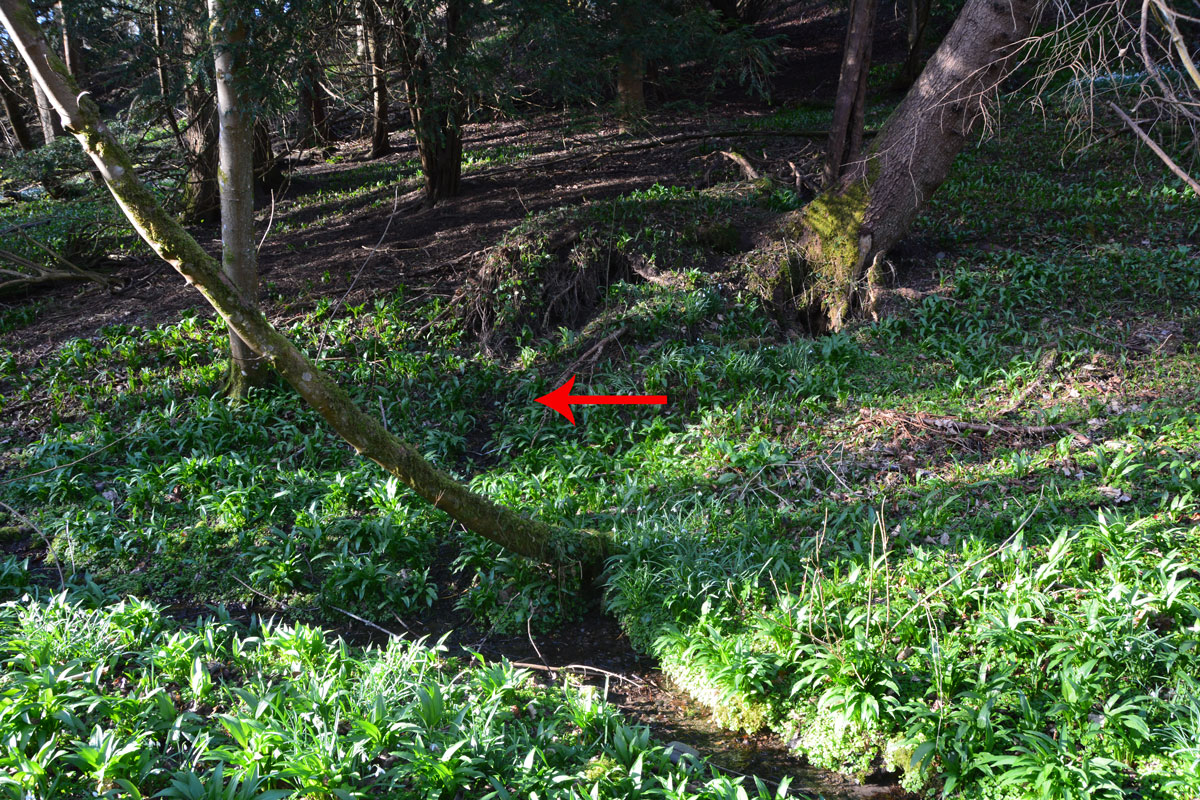
Hier Well (Benrig) submitted by Anne T on 2nd Mar 2020. The red arrow shows where the spring which feeds Hier Well emerges from the base of a wooded slope, just underneath the roots of an uprooted tree. There is a fair trickle of water emerging from the bank.
(View photo, vote or add a comment)
Log Text: Hier Well, Benrigg/Maxton: We first tried to get here by following St Cuthbert’s Way from the cemetery/old chapel ruins at Benrig, but there was a steep drop down to the river below on one side, and the path was muddy and slippery. Andrew said a set of steps down to the Crystal Well were too steep for me to cope with (although later, from below, they looked OK), so we tried again from the church by Glebe House (more details below).
We found the source of the spring, as described at the foot of a wooded slope, but no sign of the structure photographed by Cope, even though we walked alongside the stream to the wooden bridge looking.
A beautiful woodland location, and very peaceful. On the far side of the ford, another well (Well-brae) was marked on the OS map, but after heavy rain in the area, the ford was too deep to cross at this point, without wellies, which we didn't have.
Crystal Well (Benrig)
Trip No.158 Entry No.2 Date Added: 2nd Mar 2020
Site Type: Holy Well or Sacred Spring
Country: Scotland (Scottish Borders)
Visited: Yes on 27th Feb 2020. My rating: Condition 3 Ambience 4 Access 4

Crystal Well (Benrig) submitted by Anne T on 2nd Mar 2020. The spring/well grotto from its southern side. It is a very attractive feature. Whilst the spring must have older origins, the surrounding structure is 19th century.
(View photo, vote or add a comment)
Log Text: Crystal Well and Mule Gang, Benrig: We retraced our steps along the road from Hier Well almost to the wooden bridge, then turned north and followed a track through the woodland between a bank on our left hand side and the River Tweed on our right.
What looked like lime kilns came into view, although this turned out to be the very interesting Mule Gang and pump house. The gate into the Crystal Well was open, and I straddled the small stream of water emerging from it to photograph the well basin and chamber behind. The water appeared to gush straight out of gravel at the back of the well chamber.
A really beautiful location, and I’m surprised there weren’t more walkers and visitors around here.
Tamlane's Well (Carterhaugh)
Trip No.158 Entry No.4 Date Added: 5th Mar 2020
Site Type: Holy Well or Sacred Spring
Country: Scotland (Scottish Borders)
Visited: Yes on 27th Feb 2020. My rating: Condition 3 Ambience 4 Access 5

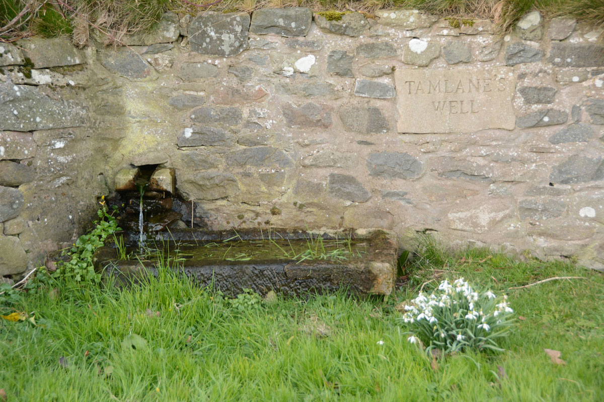
Tamlane's Well (Carterhaugh) submitted by Anne T on 5th Mar 2020. Getting closer to the well trough. The water must drain from the stone trough into a modern drain, about a metre in front of the current structure, then through a pipe under the road into a small stream/field drain in the field to the south.
(View photo, vote or add a comment)
Log Text: Tamlane's Well, Carterhaugh: A delightful spot, next to the single track B7039, parts of which aren’t terribly well defined (and we ended up in a very large farmyard, having taken a wrong turn!). The well is located right by the road, in a small grassy area just to the south of a large set of the Carterhaugh farm buildings/barns, although separated it by a dry stone wall. Whilst the original well was some 2.5m behind the wall, and is now filled in, the well is now presented in a nice way, presumably to allow visitors to access the well, which was really good of the farmers.
There was a steady flow of water into a trough which then drained into a modern manhole about a metre to the south of the well trough.
Caulks Well (Selkirk)
Trip No.158 Entry No.3 Date Added: 5th Mar 2020
Site Type: Holy Well or Sacred Spring
Country: Scotland (Scottish Borders)
Visited: Yes on 27th Feb 2020. My rating: Condition 3 Ambience 4 Access 4

Caulks Well (Selkirk) submitted by Anne T on 5th Mar 2020. Standing just to the east of the well, at the bottom of one of the mounds on the golf course. There was so much water at the time of our visit that the whole area around the well was almost ankle deep in water. It was not obvious from standing by the well how the water arrives at this location, but standing where we parked at NT 47845 27908, just across the A699, there are a series of hills behind from which the water must run down to the well.
(View photo, vote or add a comment)
Log Text: Caulks Well, Selkirk Hill: No mention on Canmore.
We parked in a small layby at NT 47734 27869, which had been largely used for dumping road repair materials, then crossed to the northern side of the A699 and walked up (North East) to the Borders Abbey Way, and followed the track some 150 metres (part of the path were icy) to the well.
Right at the edge of the Golf Course, there is such a plentiful stream of water that there are three sources of the spring in the same small area: (1) at the base of the signpost; (2) at the well house itself, and (3) in a pool which emerges just to the south of the well house. The water tumbles down to the stream below.
Source: https://blackbob.org.uk/pdf/Trail1-SelkirkHill.pdf
Turn left, and follow the track until the Borders Abbeys Way signpost (12), turn left again, to follow the Way back to the A699. You pass the Hill Shelter (13), and a picnic bench (14), then Caulks Well (15), a drinking fountain. The water from here is so good to drink that a former Provost (who shall remain nameless!) used to bring a bottle to take water from it to have with his whisky; and an Italian woman, who met and married a soldier from Selkirk at the end of WW2, coming to live in the town, would drink nothing else."
