Contributory members are able to log private notes and comments about each site
Sites Anne T has logged on trip number: 44 (View all trips)
View this log as a table or view the most recent logs from everyone
St Mary's Old Church (Brignall)
Trip No.44 Entry No.4 Date Added: 15th Sep 2017
Site Type: Ancient Cross
Country: England (County Durham)
Visited: Yes on 9th Sep 2017. My rating: Condition 2 Ambience 4 Access 4

St Mary's Old Church (Brignall) submitted by Anne T on 11th Sep 2017. The interlacing can be seen on this piece of 9th century cross shaft, built into the north wall on the west side of the opening in the wall.
(View photo, vote or add a comment)
Log Text: 9th century cross shaft, St. Mary's Old Church, Brignall: Deserted Medieval Village: After not being able to find the cross base in ‘New St. Mary’s Church’, we left the car parked in front of the church and took the footpath to ‘The Old Church’ between the south wall of the churchyard and the neighbouring house. This quickly took us down an overgrown lane, following a small stream in a deep gulley to our left hand side. As the crow flies, it’s only 500 metres from the ‘new church’ to the ‘old church’, although it felt a lot longer.
Where the trees started to clear, with fields to our right, the path turned back on itself, seeming to lead straight down the gully to our stream. There was no signpost to say where the old church was, so we took the path leading downwards (to our left), at one point walking between two streams, and came out into a meadow. In the distance was the ruins of a small buildings surrounded by a low stone wall. It looked more like a tumbled down small farm house, but as we got nearer, the grave stones appeared above the wall line.
The gate had been firmly locked with a bolt and nuts, so we used the stile over the wall, descending into brambles and nettles. Other people had obviously walked this way as there were traces of indistinct tracks leading in various directions across the churchyard.
Making our way over to the building, we couldn’t see the piece of cross shaft, so I called the image up on my phone, having to hold it high up above my head to get a better signal! Almost immediately, I spotted it – to the left hand side of the opening in the wall (north), a few layers up from the current ground level.
The Historic England entry also said that there were re-used cross slabs over the east window and the now re-filled smaller windows in the east wall. On closer inspection, these looked like re-used grave slabs.
It wasn’t until we left the grounds of the church and followed a line of boulders leading down to what we thought was a stream, that we found out the River Greta ran just to the east of the church. The rig and furrow ploughing across the field was really obvious and it may be the stones marked the line of a crossing through the river? The Historic England entry also says the site has been painted by Turner and others.
St. Mary's Church (Brignall)
Trip No.44 Entry No.3 Date Added: 15th Sep 2017
Site Type: Ancient Cross
Country: England (County Durham)
Visited: Yes on 9th Sep 2017. My rating: Condition 3 Ambience 2 Access 5

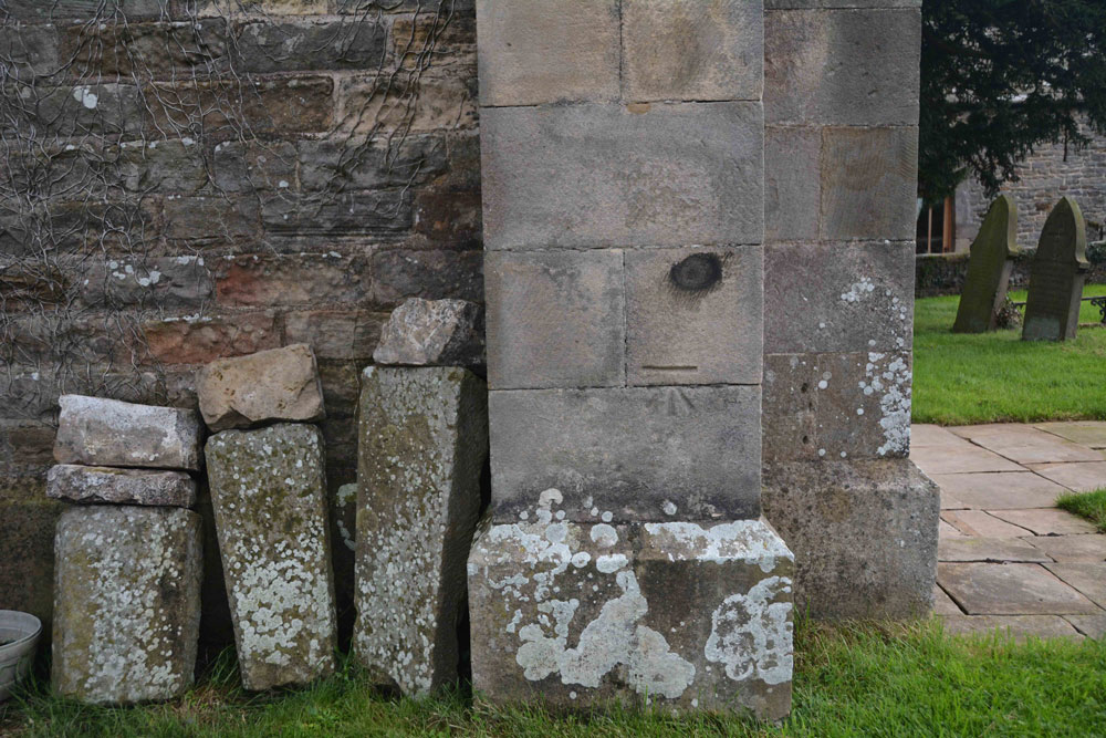
St. Mary's Church (Brignall) submitted by Anne T on 11th Sep 2017. The remains of a cross base, together with a Roman altar, are said to stand against the south wall of the church outside its west end.
This was the only collection of stones we could find on or near the church walls, and these sit against the north western corner of the tower.
(View photo, vote or add a comment)
Log Text: Cross base at St. Mary's New Church, Brignall (not found): After having visited the church in Barnard Castle and Barnard Castle, we set of to Brignall. According to Pastscape, there was a 13th century cross base sitting against the south-west corner of the tower of this church, together with a Roman altar and other stones. These used to be in the rectory gardens, but were re-sited in the churchyard.
No sign of the cross base or the altar existed, unless they are in this collection of stones, all of which are badly worn. These are located against the north west corner of the tower, behind the war memorial. There was nothing against the south west corner/south west wall of the church – I walked right round in case we’d missed anything, or they had been moved.
The church was locked at the time of our visit, so I couldn’t get inside to check if these artefacts had been moved inside for safety. As we parked up, a man in the house next to the church (to its right as photographed) was standing at the window looking at us, talking on the phone. He made no move to come out and talk to us, and made me feel like an intruder.
I will need to phone the Diocesan office to find out when the church is open and if the base and altar have been moved inside the church.
Christening Stone (Cotherstone)
Trip No.44 Entry No.1 Date Added: 15th Sep 2017
Site Type: Ancient Cross
Country: England (County Durham)
Visited: Yes on 9th Sep 2017. My rating: Condition 3 Ambience 3 Access 5

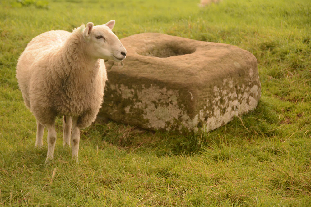
Christening Stone (Cotherstone) submitted by Anne T on 10th Sep 2017. First view of The Christening Stone from over the stone wall alongside Spout Bank (B6277), 160 metres south east of Doe Park Caravan Park.
(View photo, vote or add a comment)
Log Text: The Christening Stone, Cotherstone: This was our first stop of the day. Travelling south on the A68, the shortest route was cross-country through Hamsterley, driving along the B6278 Folly Bank into Eggleston, then turning onto the B6277 through Romaldkirk. The cross base is in a field to the right hand side of the road, 160 metres south of Doe Park caravan park, on Spout Bank.
The road is busy and narrow, but we managed to pull off into a double gateway at the side of the road and cross over to peer at the cross base. A sheep was huddled up to it when I first saw the base. The sheep then stood up once it noticed me and stood by the cross base, as if it was showing it off.
The cross looks as if it was sitting by the side of a hollow way, although now on a slope where the land dips towards the road. It looks quite crisply carved still. Although there was no gateway into the field, the stone wall was really low in places, and Andrew hopped over the wall to take a quick photograph of the western side of the base.
Pastscape says the base is Grade II listed and is in its original position on the medieval route between Cotherstone and Romaldkirk. Called The Christening Stone, a calf was christened at this cross as part of the May Day celebrations.
The Butter Stone
Trip No.44 Entry No.2 Date Added: 10th Sep 2017
Site Type: Standing Stone (Menhir)
Country: England (County Durham)
Visited: Yes on 9th Sep 2017. My rating: Condition 3 Ambience 3 Access 4
The Butter Stone submitted by durhamnature on 16th Jul 2012. The Butter Stone, the hills of Teesdale in the background.
Site in County Durham England
(View photo, vote or add a comment)
Log Text: The Butter Stone, Cotherstone: From the cross base, we continued along the B6277, turning onto the minor road from Cotherstone towards the Battle Hill Ranges. We hadn’t expected to turn from pasture and woodland almost straight onto a moorland road.
From the turning in Cotherstone to the Butter Stone is almost 1.7km. Just passing a farm entrance to the east of the road, the stone is almost immediately to the west, about 25 metres from the side of the road. A narrow grassy footpath leads from the road to the stone, which appears to be a well eroded natural erratic. It just about shows above the tussocky grass around it.
A old penny had been glued into a hollow in the top of the stone, and in the other hollows around the outside of the stone there were 20 pence pieces slotted into them.
I was surprised to find this stone was used as an exchange/boundary point during the 17th century plague, and it is sited just below the brow of the hill.
