Contributory members are able to log private notes and comments about each site
Sites Anne T has logged on trip number: 84 (View all trips)
View this log as a table or view the most recent logs from everyone
Stone of Mannan
Trip No.84 Entry No.9 Date Added: 26th Jul 2018
Site Type: Standing Stone (Menhir)
Country: Scotland (Clackmannanshire)
Visited: Yes on 14th Jul 2018. My rating: Condition 3 Ambience 4 Access 5
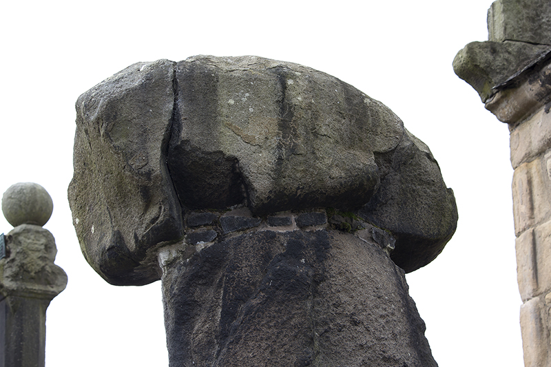
Stone of Mannan submitted by peigimccann on 27th Aug 2017. Stone of Mannan
(View photo, vote or add a comment)
Log Text: Stone of Mannan, Clackmannan: I was surprised to find this only about 20m east of the Mercat Cross (refer to that page for the rest of my visit report). Right next to the market cross and the Tolbooth. See the report above. I was interested to read the plaque on the eastern wall of the Tolbooth: “The Stone or Clack, originally placed at the foot of Lookabootye Brae, was sacred to the pre-Christian deity Mannan and is an unique relic of pagan times. It was raised on the large shaft in 1833”.
St Andrew's Church (Forteviot)
Trip No.84 Entry No.3 Date Added: 25th Jul 2018
Site Type: Class III Pictish Cross Slab
Country: Scotland (Perth and Kinross)
Visited: Visited (still working on) on 14th Jul 2018. My rating: Ambience 3 Access 5
Log Text: St. Andrew's, Forteviot: We drove up to this church to find a lovely local lady garden by the gate into the churchyard. She told us the church would be locked, "but it'll be open on 29th (July)." We explained we were only here for the day, so this was too late. She told us about the recently erected modern cross, just down the road from the church, next to the bus stop. We thanked her kindly and walked down to take a look.
Parkmill Cross (Alloa)
Trip No.84 Entry No.7 Date Added: 26th Jul 2018
Site Type: Ancient Cross
Country: Scotland (Clackmannanshire)
Visited: Couldn't find on 14th Jul 2018. My rating: Condition -1
Log Text: Parkmill Cross, Alloa: Could not find this – the grid reference seemed to be somewhere in a breaker’s yard. Parking in the nearby housing estate just to the south west of this location, we followed the footpath sign to the footpath which ran west-east along the bottom of the field this cross base is supposed to be in, the tall fence and padlocked gates prevented entry. Andrew tried to gain access from the car breakers yard to the north-west, but said it looks as if their site has been extended to cover where this cross might have been.
Mercat Cross (Clackmannan)
Trip No.84 Entry No.8 Date Added: 26th Jul 2018
Site Type: Ancient Cross
Country: Scotland (Clackmannanshire)
Visited: Yes on 14th Jul 2018. My rating: Condition 3 Ambience 4 Access 5

Mercat Cross (Clackmannan) submitted by peigimccann on 27th Aug 2017. Clackmannan market cross
(View photo, vote or add a comment)
Log Text: The Mercat Cross, Clackmannan: The Mercat Cross, the Stone of Mannan and the Tolbooth are all in the same small area. When we arrived, it was about 6.40pm and the sun was low in the sky, giving deep shadows. Much to the amusement of the people drinking outside the pub behind the Tolbooth, I took a number of photographs of these monuments, then retreated to the car to try and get out of the heat. Was worth seeing, but at this time of day I wanted something to eat, drink and cool shade!
Market Cross (Kincardine)
Trip No.84 Entry No.10 Date Added: 26th Jul 2018
Site Type: Ancient Cross
Country: Scotland (Fife)
Visited: Yes on 14th Jul 2018. My rating: Condition 3 Ambience 2 Access 5
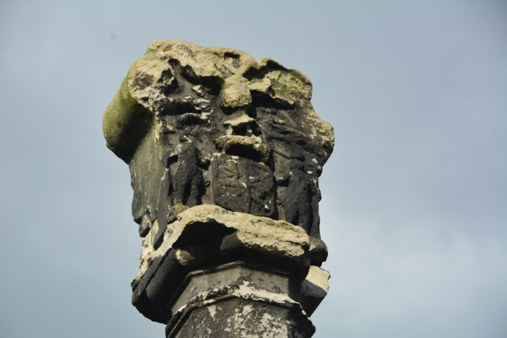
Market Cross (Kincardine) submitted by Anne T on 26th Jul 2018. Apart from the finial, this Mercat Cross in Kincardine was virtually identical in style to the Mercat Cross in Clackmannan, not that far away.
(View photo, vote or add a comment)
Log Text: Mercat Cross, Kincardine: Our last stop of this very hot day, thankfully. This cross was in a very busy stop, next to the main bus stop in the town, with lots of take away shops around the ‘triangle’ of what might have been the village green. Not an impressive site, although the cross (apart from the finial) seems almost identical to the Mercat Cross, Clackmannan. Just one to 'tick off the list' that we've seen it (and photographed it).
Gray Stone (Dunning)
Trip No.84 Entry No.5 Date Added: 26th Jul 2018
Site Type: Standing Stone (Menhir)
Country: Scotland (Perth and Kinross)
Visited: Yes on 14th Jul 2018. My rating: Condition 3 Ambience 4 Access 4
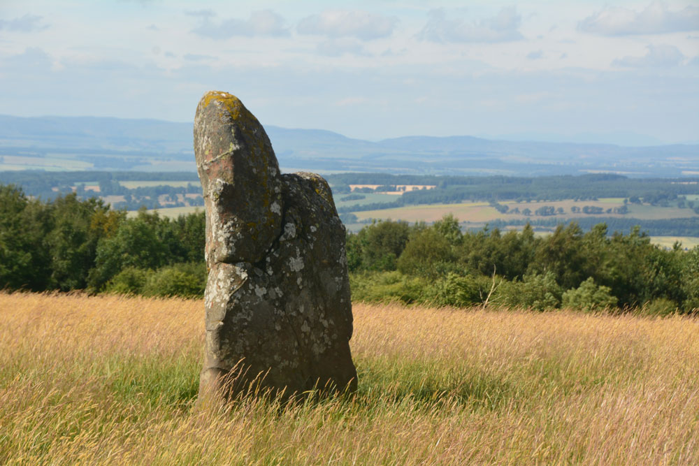
Gray Stone (Dunning) submitted by Anne T on 26th Jul 2018. Getting closer to the stone, approaching it from the gate into the field (south), we started to see the 'shoulder' on its northern side.
(View photo, vote or add a comment)
Log Text: The Gray Stone, Dunning: Thrilled to be seeing my second standing stone of the day (and one we were likely to get close to), we parked at the end of the driveway up to The Knowes farm. The stone is signposted, but the signpost follows the line of the fence and wood to the north west. Undecided whether to follow the sign and walk through the knee high grass or take the farm track which ran directly westwards. Consulting the map, we didn’t come to any firm conclusion, so to avoid having to climb over any fences, we ended up walking up the farm track, ending up at the cottage just before the gate to the big farmhouse to the left. Turning to our right here, in front of the cottage, there is a way across the deep, wide ditch which ran to our right hand side all along the track, then followed another farm track which ran north east to two field gates at NO 02171 11700. Opening the left hand gate, we let ourselves into the field, and the stone was immediately in front of us, about half way along the middle of the field, near to the fence line with the neighbouring wood which is to the stone’s eastern side.
Walking towards the stone (through what looked like a field of wheat, looking back on the photos, but is actually tall, yellow grass which has gone to seed) which is about 7ft tall, we realised it had a ‘shoulder’ to its northern side. Having seen a few other stones like this recently (the Megget Stone springs immediately to mind), I wondered if this had been deliberately cut like this, but looking at the bashes this stone has had, and the cracks and loose pieces on it, it looks as if it has fractured and a piece fallen off.
Whilst the views to the south and east are blocked now by forestry, there was a great vista northwards to Dunning and the hills (which appeared as a blue mist) in the far distance. On its northern side, there is a change in slope down from the stone; to its west and slightly to the south, there is a very slight rise. I wondered if the change in ground level might be because either farming, or perhaps a prevailing wind over time, has caused the ground level to build up here.
A very peaceful and beautiful place.
Forteviot Cross
Trip No.84 Entry No.4 Date Added: 25th Jul 2018
Site Type: Sculptured Stone
Country: Scotland (Perth and Kinross)
Visited: Yes on 14th Jul 2018. My rating: Condition 5 Ambience 4 Access 5
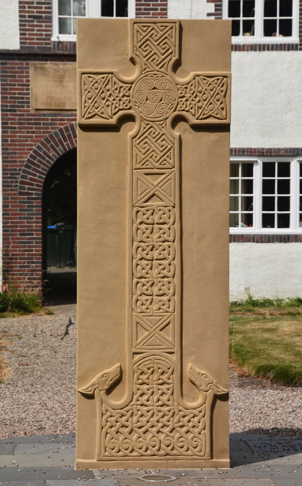
Forteviot Cross submitted by Anne T on 25th Jul 2018. The front of this modern Pictish cross slab, only unveiled in mid-March this year.
(View photo, vote or add a comment)
Log Text: Modern Pictish Cross Slab, Forteviot: Having been spooked by the Maggie Wall Memorial and disappointed at not being able to get into Forteviot parish church (St. Andrews), the lady gardener told us to walk down the road to look at the new cross slab that had just been erected.
Just behind the bus-stop, and in front of a charming courtyard of whitewashed houses, we found out later this cross had been erected only on either 17th or 18th March 2018, so very new.
The lady gardener told us there were some leaflets ‘in the bus stop’ and indeed there were several tucked underneath the bus timetable board. The cross was carved by David McGovern, of Monikierockart for the 2017 Tay Landscape Partnership project. “In the form of a Pictish Cross Slab, the new cross celebrates Forteviot’s status as an early Christian site and its association with King Cinead mac Alpin. The Pictish stone fragments that inspired the cross design can also be visited across the road in St Andrew’s Church (when open).” The leaflet also gives a guide to the patterns on the cross.
Dupplin Cross
Trip No.84 Entry No.1 Date Added: 25th Jul 2018
Site Type: Ancient Cross
Country: Scotland (Perth and Kinross)
Visited: Yes on 14th Jul 2018. My rating: Condition 4 Ambience 4 Access 5
Dupplin Cross submitted by cosmic on 16th May 2007.
Back of the cross with the dedication panel top middle
(View photo, vote or add a comment)
Log Text: Dupplin Cross, St Serf's, Dunning: Our first stop of the day, and a very old, popular, tourist village. We first saw a drinking fountain outside the churchyard, almost at the cross roads.
By the southern door to the church were two hogbacks.
Inside was the Duppline Cross and a smaller cross slab to its north west. There was a guide, already talking to a gentleman about the cross, but when she saw us, she interrupted her talk and came up to us to ask us to join in. Not usually one for ‘tours’ we reluctantly joined her, as I really wanted space and time to drink in this cross on my own, then photograph it; this was not to be, as there was a steady stream of visitors coming into the church. As we went out, another family came in, followed later by a large walking group.
I photographed most of the individual panels around the Dupplin cross and need to sort these out using the diagrams in the 'Official Souvenir Guide' (£1). I was particularly fascinated by the base, which appeared to have carved lines across one corner, and cups (or very worn interlacing) on its base.
Dunning
Trip No.84 Entry No.2 Date Added: 25th Jul 2018
Site Type: Standing Stone (Menhir)
Country: Scotland (Perth and Kinross)
Visited: Saw from a distance on 14th Jul 2018. My rating: Condition 3 Ambience 3 Access 4

Dunning submitted by Nick on 5th Nov 2002. The stone looking north
(View photo, vote or add a comment)
Log Text: Dunning North Standing Stone: From St Serf’s church, we walked along Kirk Wynd, down alongside the stream, down past some cottages, to where the footpath split. The standing stone was right in front of us, albeit in the middle of a ripening crop of wheat. It seemed very far away, and I was very, very reluctant to trample any of the crop, so we stuck to the footpath. With the camera lens on maximum zoom I tried to capture the different faces of the stone, but as the footpath ran roughly west-east, we couldn’t really get close.
The guide in the church told us there were two standing stones nearby; most people visited the northern (this) stone, but apparently not many people went to the southern stone.
If the field hadn’t been set with a crop, I’d have been tempted to look for the gate, or an alternate route to get closer.
Our next stop was to the very peculiar "Maggie Wall Monument", 1km west of Dunning on the B8062. This is a 20ft tall monument topped by a cross to a witch called Maggie Wall who was apparently burnt in 1657. The stories I've all tracked down say Maggie Wall didn't exist. This monument definitely made me shiver!
Castleton (Dollar)
Trip No.84 Entry No.6 Date Added: 26th Jul 2018
Site Type: Standing Stone (Menhir)
Country: Scotland (Clackmannanshire)
Visited: Yes on 14th Jul 2018. My rating: Condition 4 Ambience 4 Access 4
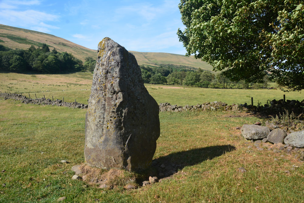
Castleton (Dollar) submitted by Anne T on 26th Jul 2018. Standing stone in Clackmannanshire Scotland. Standing just to the south west of the stone, looking at its location in relation to the surrounding hills and capturing its shadow at this time of the evening.
(View photo, vote or add a comment)
Log Text: Castleton Standing Stone, Pool of Muckhart: To find this stone, we followed the signs to the ‘Japanese’ garden, which had a large car park. The entrance and part of the car park were still in the process of being constructed, but was obviously just about to close for the night, so we parked as close a wall outside the entrance. Scanning the field for a gate, there was one by the farm house, some distance away (and it looked as if there was a small stream we’d have had to cross to reach the stone) or an old, painted red iron gate (very ornate) virtually opposite from where we parked. This had not been used in some time, and our usual gate opening skills didn’t work. We ended up climbing over the gate and walked across the field.
It was by now so hot and sticky, that the sheep had taken shelter under the trees to the east of this stone, in what looked like an old sheep fold, now fallen into ruin. This standing stone had two sides which were eroded, one with what looked like cups, but (having seen similar examples doing the ERA data entry exercise) are probably small holes where pebbles have fallen out, or possible solution holes if the stone had lain on the ground for some considerable time.
A very lovely spot, with gentle rolling hills to the north and north west.
