Contributory members are able to log private notes and comments about each site
Sites Anne T has logged on trip number: 9 (View all trips)
View this log as a table or view the most recent logs from everyone
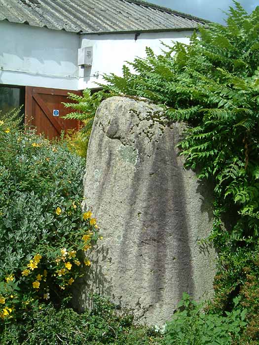
Skirsgill Standing Stone
Trip No.9 Entry No.1 Date Added: 13th Feb 2017
Site Type: Standing Stone (Menhir)
Country: England (Cumbria)
Visited: Yes on 12th Feb 2017. My rating: Condition 2 Ambience 3 Access 5

Skirsgill Standing Stone submitted by stu on 16th Jul 2004. NY5098 2874.
On the Skirsgill industrial estate near Penrith. Stone stands at the rear of the Liliput Lane factory.
(View photo, vote or add a comment)
Log Text: Skirsgill Standing Stone, Penrith: Situated in Skirsgill Business Park, just to the west of the southern part of Penrith, we’ve tried visiting this stone before, but never found it.
From Penrith, heading west across the M6 on the A66 towards Ullswater, take the very first turn into the Skirsgill Industrial Estate (easy to drive past, as it has a very short feeder lane into it). Follow the one way system into the industrial estate (note the intriguing thatched building to your left) and continue straight ahead between the two sets of industrial units. After several hundred metres, you will see a dead end with a gate leading into the field, an CrossFit Cumbria to your left. Parking can be difficult during the week, but plenty of spaces during the weekend. Walk along the dead end road towards the field, with the CrossFit building to your left. The standing stone can be found immediately at the end of this building. Was the building built to accommodate the stone, or has the stone been relocated to form part of its garden?
The face of the stone nearest to the building appears to have been quarried in more recent times, as the face is ‘squared off’. There is some modern grafitti on it.
Not the best of locations, but certainly intriguing! Could only find the Historic England listing – nothing in Pastscape.
Sewborrans Stone
Trip No.9 Entry No.2 Date Added: 14th Feb 2017
Site Type: Standing Stone (Menhir)
Country: England (Cumbria)
Visited: Yes on 12th Feb 2017. My rating: Condition 3 Ambience 3 Access 4

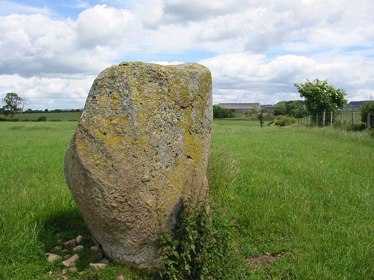
Sewborrans Stone submitted by stu on 16th Jul 2004. NY4884 2999.
1.5m high stone. Visible from the road.
(View photo, vote or add a comment)
Log Text: Sewborwens Standing Stone (and outliers), Penrith, Cumbria: From the Skirsgill Standing Stone, we made our way back on the A66, heading westwards (you can only turn left onto this dual carriageway). Turning round at the next roundabout, heading back to Penrith, we took the first left hand turn down the mnor road leading past the golf driving range and Greystoke Pillar (18th century monument to the 11th Duke of Norfolk). About 1.5 kms down this road from the A66, there is a barn on the right hand side of the road with a small (muddy) layby next to it. There is a gate into the main field to the east of the barn and the standing stone is visible next to the first fence line to the east.
There was nothing in the field, so we kept to its edge to look at the stone. Before reaching the stone, I spotted two more smaller stones in the hedge line, which looked like part of a row or avenue leading to the stone.
Having photographed the stone, I spotted more large stones against the wire fence. This modern fence has been put on top of what looked like an old (medieval?) stone wall line. There were at least three large boulders, two looking like they had been shaped and with flat bottoms, which had been moved against the old wall to clear the field.
An email to Cumbria County Council provided the information: "there are 2 smaller stones which may be related to the larger stone, beside the hedgerow bordering the B5288 and about 120 metres bearing 280 degrees from the major stone. The southernmost stone is c1.08 metres and the northermost stone is c0.75 metres.” They also added that notes from 1973 tell us: “Thompson records the ‘remnants of a stone sepulchural ring at Sewborrans”, but he doesn’t know what the original source was.
Mossthorn Long Cairn 2
Trip No.9 Entry No.3 Date Added: 13th Feb 2017
Site Type: Cairn
Country: England (Cumbria)
Visited: Yes on 12th Feb 2017. My rating: Condition 3 Ambience 3 Access 5

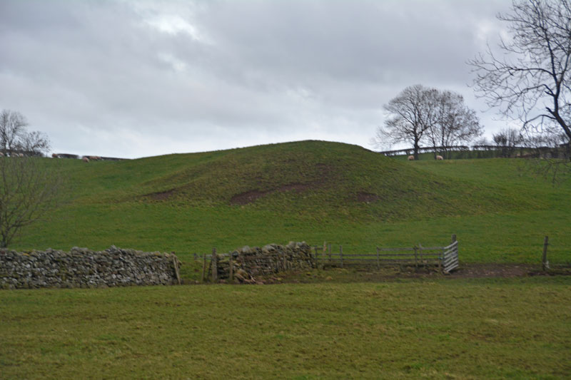
Mossthorn Long Cairn 2 submitted by Anne T on 13th Feb 2017. The long cairn at grid reference NY 48289 30440, taken from the layby outside The Wreays on the minor road from the A66 to Greystoke.
(View photo, vote or add a comment)
Log Text: Long Cairns near Mossthorn Farm, near Sewborwens Standing Stones: From Sewborwens Standing Stone(s), we drove westwards along this minor road, through the roadworks currently there, and parked in the layby outside The Wreay. The first long cairn is visible in the field immediately opposite.
Crossing the road to photograph this site, the wind chill must have been -5 degrees C, with the occasional flake of sleet. The roadworks had churned up the grass, so I waded through almost ankle deep mud to the stone wall and got a closer photograph.
We didn’t realise there was a second cairn at grid reference NY 48258 30606 until I checked on the Historic England site.
Given we want to come back and track the standing stones in Newbeggin Village at some point, I’m going to write to the farm to ask permission to walk the fields to see both long cairns at closer quarters.
Newbeggin Stone Row
Trip No.9 Entry No.4 Date Added: 15th Feb 2017
Site Type: Stone Row / Alignment
Country: England (Cumbria)
Visited: Visited (still working on) on 12th Feb 2017

Newbeggin Stone Row (Possible) submitted by Anne T on 28th Mar 2017. This stone is built into a stone wall on a footpath which follows the Carlsike Burn, around Hoghouse Hill to Newbeggin. Located at NY 48058 29531. Note: 3rd April 2017. The Lead Officer for the Historic Environment and Commons says "This is slightly more interesting. I would not like to guess at when this might have been erected."
(View photo, vote or add a comment)
Log Text: Newbiggin Stone Row, near Penrith: See comment on main page. Tried to find. Seen an image of a stone in an enclosure wall but unable to locate. Working on finding exact location and will return!
Newbeggin Wells
Trip No.9 Entry No.5 Date Added: 15th Feb 2017
Site Type: Holy Well or Sacred Spring
Country: England (Cumbria)
Visited: Yes on 12th Feb 2017. My rating: Condition 3 Ambience 3 Access 5

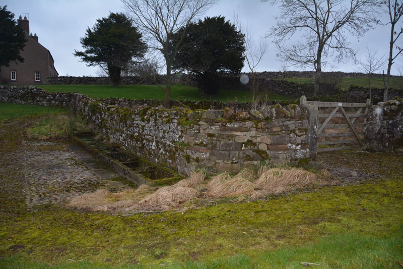
Newbeggin Wells submitted by Anne T on 14th Feb 2017. The Prospect Well, which is located on the village green in the middle of Newbeggin. The main well chamber is located behind the stone wall, with troughs set against the exterior wall. There was a fair flow of water into the troughs at the time of the visit. The water didn't taste of any particular mineral.
(View photo, vote or add a comment)
Log Text: Newbeggin Wells, near Sewborwens Standing Stone: We went originally to try and trace the standing stones, one of which stood in the wall of Rosemary House (we found Rosemary Cottage but not the house) and another which stood in the field behind.
Parking at the side of the road near Rosemary Cottage, opposite Sunbeam Well, we braved the sleet. It was getting to be dusk and cold, and light conditions were really weird. We walked the hundred or so yards between the two wells, then set off in seach of Holme Head standing stone, before it got dark.
I have since emailed the clerk of Dacre Parish Council to try to find out the location of the above stone, and to seek the landowners’ name, so we can visit.
Wikipedia, and Dacre Parish Council, record that Newbeggin is an ancient village, built on the Putnam Fault, which provides a line of springs running through the village. Neolithic burials have been found on nearby Flusco Pike and there are a number of barrows and cairns and other standing stones in close proximity.
Lowhouse
Trip No.9 Entry No.6 Date Added: 15th Feb 2017
Site Type: Stone Circle
Country: England (Cumbria)
Visited: Yes on 12th Feb 2017. My rating: Condition 3 Ambience 3 Access 4

Lowhouse submitted by stu on 16th Jul 2004. Kitchenhill Bridge Stone (Lowhouse?), NY4961 3434.
Standing by the West Coast Mainline, this is a massive stone at least 3m tall. Not marked on the O.S maps.
(View photo, vote or add a comment)
Log Text: Lowhouse/Holme Head/Kitchenhill Standing Stone, Penrith, Cumbria: From Newbeggin, heading back up the M6, leaving at junction 41, turning right onto the B5305 and taking the first exit off the roundabout, we headed up the minor road signposted to Calthwaite. Where the road divides at Kitchenhill Farm, we turned right, heading over the railway line, then immediately over the small bridge over the River Petterill. At grid reference NY 49802 34135 there is a left hand turn on the bend, leading down to a small area of land by the river, used by the farmer for storing hay. There is room here for one car to park at the entrance. We walked back the short distance over the bridge over the river and went to look over the gate into the field. At first, in the gathering dusk, we couldn’t see anything, but then at the far end of the field, sheltered by a large tree, we spotted this huge grey stone.
The field is guarded by a barbed wire topped gate. I don’t like trespassing, but there was nothing in the field, so we let ourselves gingerly in and followed the tractor trail over the grass to the stone. It is huge. I spotted what seemed like other smaller (grey) stones in the base of the red sandstone wall to the right-hand side of the field. Getting closer to the stone, it sits on (what was) a lovely spot (pre railway line), overlooking the gently meandering river below.
Andrew was keen to try and get sight of two other stones in the area (and another I’d spotted travelling south on the M6 on the way down), so we drove to Plumpton, slightly further north, stopping near Plumpton Wall Farm to peer over the fields, but could see nothing. We retraced our route and headed off towards Calthwaite, stopping at the entrance to Hallrigg to peer eastwards over the fields. With the sleet hammering in our faces, Andrew got the binoculars out and spotted a stone next to Calgarth Plantation at grid reference NY 48253 37527. Looking on UK Grid Reference Finder, I couldn’t see any sign of it, although this is an old map on the Modern Antiquarian web site which would be worth investigating.
