Contributory members are able to log private notes and comments about each site
Sites Chrus has logged. View this log as a table or view the most recent logs from everyone
Kermario Dolmen
Date Added: 12th Sep 2016
Site Type: Burial Chamber or Dolmen
Country: France (Bretagne:Morbihan (56))
Visited: Yes on 1st Jan 2015. My rating: Condition 3 Ambience 3 Access 4
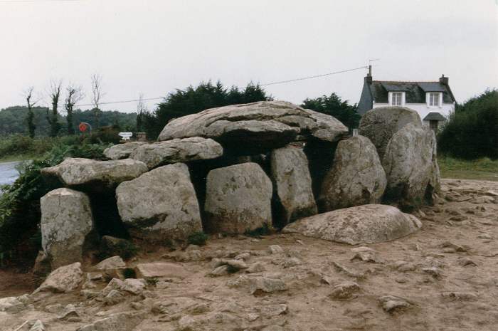
Kermario Dolmen submitted by thecaptain on 18th Oct 2004. Kermario Dolmen, north of Carnac, Brittany.
View of the Kermario Dolmen which is right at the southwest corner of the Kermario Alignements, and right in the corner of the road which skirts the site.
This picture was taken in 1987 when people were free to wander amongst the stones as they pleased. The terrible erosion caused by all the visitors is only too obvious.
(View photo, vote or add a comment)
Log Text: None
Saint-Michel tumulus
Date Added: 12th Sep 2016
Site Type: Chambered Cairn
Country: France (Bretagne:Morbihan (56))
Visited: Yes on 1st Jan 2015. My rating: Condition 4 Ambience 4 Access 4

Saint-Michel tumulus submitted by DrewParsons on 7th Nov 2009. The locked south west entrance to the tumulus.
(View photo, vote or add a comment)
Log Text: None
Ménec alignements
Date Added: 12th Sep 2016
Site Type: Multiple Stone Rows / Avenue
Country: France (Bretagne:Morbihan (56))
Visited: Yes on 1st Jan 2015. My rating: Condition 5 Ambience 5 Access 4

Ménec alignements submitted by thecaptain on 18th Oct 2004. Ménec alignements, north of Carnac, Brittany, France.
View of the Ménec alignements as they were in summer 1987, when you could walk amongst them before they were fenced off, and with an awful lot of erosion going on around them.
(View photo, vote or add a comment)
Log Text: None
Ménec cromlech
Date Added: 12th Sep 2016
Site Type: Stone Circle
Country: France (Bretagne:Morbihan (56))
Visited: Yes on 1st Jan 2015. My rating: Condition 4 Ambience 5 Access 4

Ménec cromlech submitted by AlexHunger on 20th Dec 2004. The Cromlec de Menec marks the westernmost extent of the Carnac Allignments. It basically starts on the road that separates it from the allignments, goes through a private garden, through the end of the village and ends in a creperie.
(View photo, vote or add a comment)
Log Text: None
Pierres Plates (Locmariaquer)
Date Added: 12th Sep 2016
Site Type: Burial Chamber or Dolmen
Country: France (Bretagne:Morbihan (56))
Visited: Yes on 1st Jan 2015. My rating: Condition 4 Ambience 5 Access 3

Pierres Plates (Locmariaquer) submitted by ermine on 27th Jun 2004. Les Pierres Plates
(View photo, vote or add a comment)
Log Text: None
Er-Grah tumulus
Date Added: 12th Sep 2016
Site Type: Chambered Tomb
Country: France (Bretagne:Morbihan (56))
Visited: Yes on 1st Jan 2015. My rating: Condition 4 Ambience 4 Access 4
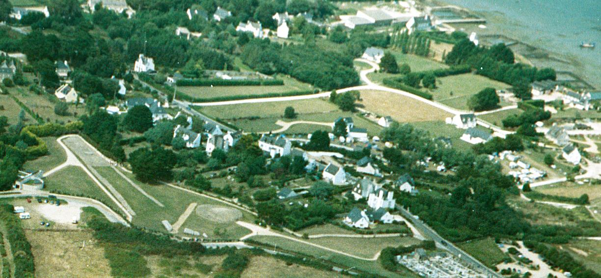
Er-Grah tumulus submitted by JJ on 8th Oct 2003. Er Grah tumulus, Grand Menhir Brisé, and La Table des Marchands, Locmariaquer.
Aerial photo copyright JJ Evendon
(View photo, vote or add a comment)
Log Text: None
La Table des Marchands
Date Added: 12th Sep 2016
Site Type: Burial Chamber or Dolmen
Country: France (Bretagne:Morbihan (56))
Visited: Yes on 1st Jan 2015. My rating: Condition 4 Ambience 5 Access 4

La Table des Marchands submitted by JJ on 9th Nov 2002. La Table des Marchands
(View photo, vote or add a comment)
Log Text: None
Grand Menhir Brisé
Date Added: 12th Sep 2016
Site Type: Standing Stone (Menhir)
Country: France (Bretagne:Morbihan (56))
Visited: Yes on 1st Jan 2015. My rating: Condition 3 Ambience 4 Access 5

Grand Menhir Brisé submitted by ermine on 27th Jun 2004. Grand Menhir Brisé, Locmariaquer.
A megalithic tragedy.
(View photo, vote or add a comment)
Log Text: None
Roche-aux-Fées (Essé)
Date Added: 12th Sep 2016
Site Type: Passage Grave
Country: France (Bretagne:Ille-et-Vilaine (35))
Visited: Yes on 1st Jan 2015. My rating: Condition 5 Ambience 5 Access 4

Roche-aux-Fées (Essé) submitted by AlexHunger on 21st Sep 2004. Roches Aux Fees viewed from North West
(View photo, vote or add a comment)
Log Text: None
Cordon des Druides
Date Added: 12th Sep 2016
Site Type: Stone Row / Alignment
Country: France (Bretagne:Ille-et-Vilaine (35))
Visited: Yes on 1st Jan 2016. My rating: Condition 4 Ambience 5 Access 3
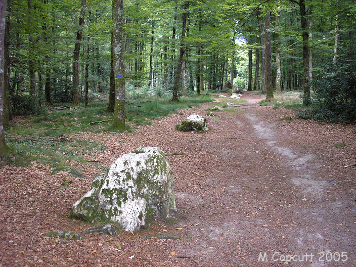
Cordon des Druides submitted by TheCaptain on 29th Jun 2007. This long line of white quartz stones is easy to find in the Fougères Forest.
The main row is about 250 metres long, and the white quartz blocks are spaced at about 3 metres apart.
(View photo, vote or add a comment)
Log Text: None
Bougon Tumulus
Date Added: 12th Sep 2016
Site Type: Barrow Cemetery
Country: France (Poitou:Deux-Sèvres (79))
Visited: Yes on 1st Jan 2012. My rating: Condition 4 Ambience 5 Access 5
Bougon Tumulus F submitted by TheCaptain on 5th Sep 2010. The ancient Bougon Tumulus F0, is at the southern end of the tumulus, and is a circular construction containing a circular chamber.
It has been dated to the middle of the 5th millenium BC, and as such is the oldest dated construction of all the Atlantic facing lands.
(View photo, vote or add a comment)
Log Text: None
Avebury
Date Added: 12th Sep 2016
Site Type: Stone Circle
Country: England (Wiltshire)
Visited: Yes on 1st Jan 2014. My rating: Condition 5 Ambience 5 Access 5

Avebury submitted by JJ on 15th Nov 2015. Photograph taken nearly 10 years ago, recently scanned.
I got there before dawn to capture the wonderful images of the sun rising when there was freezing fog.
[With many thanks to Runemage for processing JJ's photos for publication]
(View photo, vote or add a comment)
Log Text: None
Silbury Hill
Date Added: 11th Sep 2016
Site Type: Artificial Mound
Country: England (Wiltshire)
Visited: Yes on 1st Jan 2014. My rating: Condition 4 Ambience 5 Access 3
Silbury Hill submitted by MikeyB on 26th Nov 2012. Reflections of Silbury Hill
(View photo, vote or add a comment)
Log Text: None
The Sanctuary.
Date Added: 11th Sep 2016
Site Type: Stone Circle
Country: England (Wiltshire)
Visited: Yes on 1st Jan 2014. My rating: Condition 2 Ambience 4 Access 4
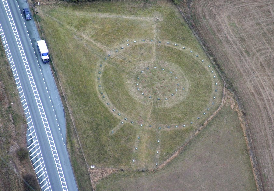
The Sanctuary. submitted by JJ on 4th Nov 2003. Aerial Photograph copyright JJ Evendon
(View photo, vote or add a comment)
Log Text: None
West Kennett Long Barrow
Date Added: 11th Sep 2016
Site Type: Long Barrow
Country: England (Wiltshire)
Visited: Yes on 1st Jan 2014. My rating: Condition 4 Ambience 5 Access 3
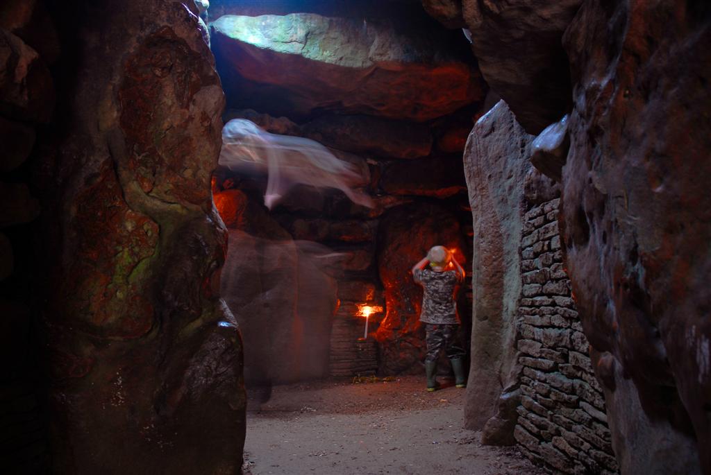
West Kennett Long Barrow submitted by jackdaw1 on 16th Oct 2007. A shot taken inside West kennet long barrow nr. Avebury on 25 sec exposure at f16-conjuring spooky feels.
A small child called jake was happily playing and respectfully enjoying the atmosphere in there.
(View photo, vote or add a comment)
Log Text: None
Le Couperon
Date Added: 11th Sep 2016
Site Type: Passage Grave
Country: Channel Islands and Isle of Man (Jersey)
Visited: Yes on 1st Jan 2016. My rating: Condition 4 Ambience 5 Access 4

Le Couperon submitted by Adam Stanford on 25th Nov 2004. Situated on the promontory at the east side of Rozel Bay in the NE corner of jersey, roofed with seven capstones and surrounded by 18 upright stones. It dates from approximately 3000BC and was covered with a long mound, but now is completely exposed as a result of poor excavation in the last century. The conglomerate stones form a rectangular chamber 8m long and 0.9m wide and 0.9m high, surrounding it is a rectangular enclosure. When it was excavated, potsherds and flints were found. An interest...
(View photo, vote or add a comment)
Log Text: Recently (2015) about half of the Pine tree fell on a corner of the dolmen. Difficult to see what damage until cleared, but it seems minor.
La Hougue des Géonnais
Date Added: 11th Sep 2016
Site Type: Passage Grave
Country: Channel Islands and Isle of Man (Jersey)
Visited: Yes on 1st Jan 2016. My rating: Condition 3 Ambience 4 Access 4
La Hougue des Géonnais submitted by MAIGO on 15th Jun 2008. This is a lovely place.
(View photo, vote or add a comment)
Log Text: None
Faldouet Dolmen
Date Added: 11th Sep 2016
Site Type: Burial Chamber or Dolmen
Country: Channel Islands and Isle of Man (Jersey)
Visited: Yes on 1st Jan 2016. My rating: Condition 3 Ambience 5 Access 4
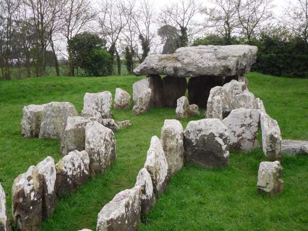
Faldouet Dolmen submitted by attlebax on 16th May 2011. This site is well marked from the road and is on the Jersey map. The lane outside is narrow and has high banks so it is best to park just up the road. Not easy for any wheelchair users.
(View photo, vote or add a comment)
Log Text: None
Ville ès Nouaux
Date Added: 11th Sep 2016
Site Type: Burial Chamber or Dolmen
Country: Channel Islands and Isle of Man (Jersey)
Visited: Yes on 1st Jan 1998. My rating: Condition 3 Ambience 3 Access 5
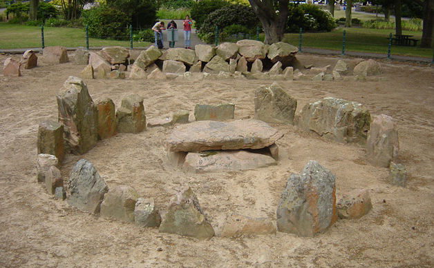
Ville ès Nouaux submitted by Adam Stanford on 25th Nov 2004. Ville ès Nouaux which consisits of a Cist-in-circle and a Gallery grave on the outskirts of St Helier. Situated in St Andrews Park a fenced off circular area contains two tombs; the first is a gallery grave which is 11.5m long, 1.2m wide and lm high. Seven capstones are in place on the roof, but unfortunately two were lost in the 19th century when sand that covered it was excavated. Damage had also occurred before the sand built up over it, in about 1000BC this then formed a protective layer, b...
(View photo, vote or add a comment)
Log Text: None
Le Mont Ubé
Date Added: 11th Sep 2016
Site Type: Passage Grave
Country: Channel Islands and Isle of Man (Jersey)
Visited: Yes on 1st Jan 2016. My rating: Condition 4 Ambience 4 Access 4

Le Mont Ubé submitted by Adam Stanford on 25th Nov 2004. Situated at the top of a short, snaking footpath up the side of a steep wooded slope. This Dolmen is completely open with no mound or capstones, the chamber is 12.3m long and 1.7m high with its widest section being 7.2m. 28 uprights still stand, forming a passage into the burial chamber, which is similar to the tomb at La Hougue Bie. The location, is high up on the slope but was not the highest point, a few hundred metres away on the top of the hill is a tower. The stones that would have defined...
(View photo, vote or add a comment)
Log Text: Recent work carried out to remove spray-paint grafitti, by powerwasher. End stones now have areas clean of lichen.
A private garden backs onto the site with some litter and builder's rubbish and a disused outhouse rather detracts from these impressive stones.
A Jersey National Trust employee found a Roman coin whilst strimming in 1999 (but then immediately lost it again).
