Contributory members are able to log private notes and comments about each site
Sites JimChampion has logged. View this log as a table or view the most recent logs from everyone
Hambledon Hill hillfort
Date Added: 19th Sep 2010
Site Type: Hillfort
Country: England (Dorset)
Visited: Yes on 10th Jan 2005

Hambledon Hill hillfort submitted by JimChampion on 10th Jan 2005. December 2002. Looking towards the south at the impressive west-facing flank of Hambledon hill. The ramparts are clearly visible in this picture, and the grazing sheep give a sense of scale. The ramparts in the foreground drop away sharply - presumably as the result of a landslip.
(View photo, vote or add a comment)
Log Text: None
Spettisbury Rings
Date Added: 19th Sep 2010
Site Type: Hillfort
Country: England (Dorset)
Visited: Yes on 10th Jan 2005

Spettisbury Rings submitted by JimChampion on 10th Jan 2005. A dull day in December 2003. A view of the simple entrance to Spettisbury Rings earthworks (also known as Crawford Castle), as indicated by my assistant.
(View photo, vote or add a comment)
Log Text: None
Nettlecombe Tout
Date Added: 19th Sep 2010
Site Type: Promontory Fort / Cliff Castle
Country: England (Dorset)
Visited: Yes on 1st Feb 2005

Nettlecombe Tout submitted by JimChampion on 1st Feb 2005. January 2005. Looking southwest along the top of the rampart. The ditch is to the left and the fort is to the right. This end of the bank has recently been cleared of trees, but the rest of it is still fairly densely covered. The interior of the fort is grazed by sheep.
(View photo, vote or add a comment)
Log Text: None
Giant's Grave Sarsen Stone
Date Added: 19th Sep 2010
Site Type: Standing Stone (Menhir)
Country: England (Dorset)
Visited: Yes on 31st Jan 2005

Giant's Grave Sarsen Stone submitted by JimChampion on 31st Jan 2005. January 2005. The Giant's Grave sarsen stone (roughly 1 metre across), looking north towards Nordon Hill.
(View photo, vote or add a comment)
Log Text: None
Nordon Hill Tumulus
Date Added: 19th Sep 2010
Site Type: Round Barrow(s)
Country: England (Dorset)
Visited: Yes on 4th Feb 2005
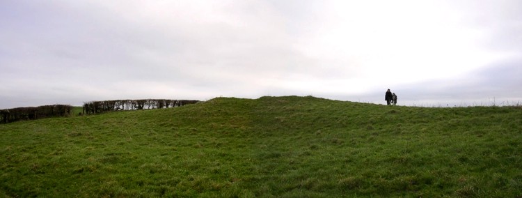
Nordon Hill Tumulus submitted by JimChampion on 4th Feb 2005. January 2005. The Norden Hill tumulus, viewed from the west. It stands on the chalk ridge of Norden Hill, a few hundred metres east of the Dorsetshire Gap: a confluence of ancient trackways. The barrow is broad, uneven, and has a depression at its summit.
(View photo, vote or add a comment)
Log Text: None
Knowlton Rings
Date Added: 19th Sep 2010
Site Type: Henge
Country: England (Dorset)
Visited: Yes on 27th Feb 2005

Knowlton Rings submitted by JimChampion on 27th Feb 2005. February 2005. Composite image of Knowlton Henge under a heavy winter sky.
(View photo, vote or add a comment)
Log Text: None
Dorset Cursus
Date Added: 19th Sep 2010
Site Type: Cursus
Country: England (Dorset)
Visited: Yes on 31st Mar 2005
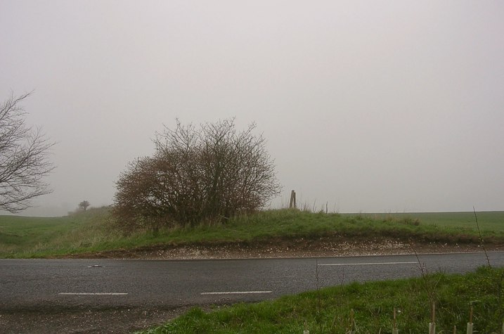
Dorset Cursus submitted by JimChampion on 31st Mar 2005. A cross-section of the southern bank of the cursus where it crosses the B3081 road (at grid ref SU018159) on Bottlebush Down. There are no such visible remains of the northern bank which crosses the road about 100m to the northwest. This slight bank is one of the few surviving parts of the neolithic cursus which once stretched for 6 miles along the undulating chalk downlands of Cranborne Chase.
(View photo, vote or add a comment)
Log Text: None
Pentridge 2
Date Added: 19th Sep 2010
Site Type: Long Barrow
Country: England (Dorset)
Visited: Yes on 31st Mar 2005

Pentridge 2 submitted by JimChampion on 31st Mar 2005. March 2005. Composite image of the Pentridge 2 long barrow(s) looking south-west from the bank of Bokerley Dyke. This is a looooong barrow, with its SE end disappearing off the edge of the photo. The site of the Dorset Cursus' north-eastern terminal is just to the right of this picture, although it was not noticeable in the young wheat.
(View photo, vote or add a comment)
Log Text: None
Pentridge 1
Date Added: 19th Sep 2010
Site Type: Long Barrow
Country: England (Dorset)
Visited: Yes on 31st Mar 2005
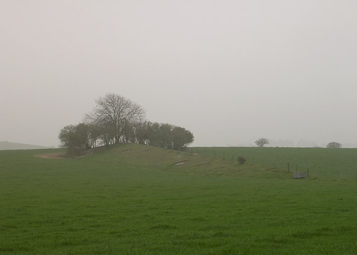
Pentridge 1 submitted by JimChampion on 31st Mar 2005. March 2005. Looking south at the long barrow from the bridleway on a rather misty day.
(View photo, vote or add a comment)
Log Text: None
Wyke Down henge
Date Added: 19th Sep 2010
Site Type: Henge
Country: England (Dorset)
Visited: Yes on 2nd Apr 2005
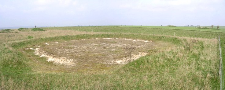
Wyke Down henge submitted by JimChampion on 2nd Apr 2005. A composite image of the larger Wyke Down henge, excavated in 1983/84. This view is looking NNW, which shows that the original entrance (in the foreground) is aligned to the SSE (as is the more recently excavated nearby henge). In the background on the right are two nearby round barrows.
(View photo, vote or add a comment)
Log Text: None
Wyke Down barrows
Date Added: 19th Sep 2010
Site Type: Round Barrow(s)
Country: England (Dorset)
Visited: Yes on 2nd Apr 2005
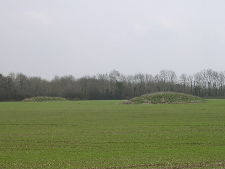
Wyke Down barrows submitted by JimChampion on 2nd Apr 2005. Looking east at two of the Bronze Age round barrows towards the south of the group on Wyke Down. The course of the neolithic Dorset Cursus runs between these two barrows, with the nearest barrow (grid ref SU009151) just north of the NW bank and the further barrow (grid ref SU010151) mid-way between the banks. The line of trees running across the background of the picture are growing on the Roman-built Ackling Dyke.
(View photo, vote or add a comment)
Log Text: None
Chalbury
Date Added: 19th Sep 2010
Site Type: Hillfort
Country: England (Dorset)
Visited: Yes on 4th Apr 2005

Chalbury submitted by JimChampion on 4th Apr 2005. April 2005. Looking west from the top of Chalbury hillfort, the remains of the fortifications are in the foreground. The un-natural pits in the opposite hill are very striking, and I haven't yet found an explanation of them (the OS map and google give nothing). Their grid ref is something like SY687836: anyone know what they are?
(View photo, vote or add a comment)
Log Text: None
Northdown (Dorset)
Date Added: 19th Sep 2010
Site Type: Barrow Cemetery
Country: England (Dorset)
Visited: Yes on 5th Apr 2005
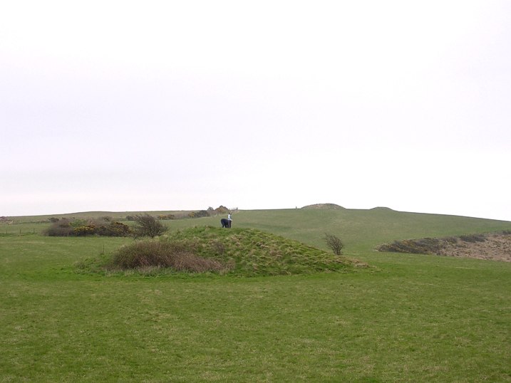
Northdown (Dorset) submitted by JimChampion on 5th Apr 2005. April 2005. The group of round barrows nearest to the ruins of Northdown Barn: those on the highest ground (near a trig point) are 158m above sea level but only 2km from the sea. A spectacularly lofty resting place for any Bronze-ager.
(View photo, vote or add a comment)
Log Text: None
Broadmayne Bank Barrow
Date Added: 19th Sep 2010
Site Type: Long Barrow
Country: England (Dorset)
Visited: Yes on 5th Apr 2005
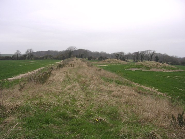
Broadmayne Bank Barrow submitted by JimChampion on 5th Apr 2005. Looking along the 600ft long bank barrow from the E end. Two neighboring round barrows are visible on the right, with Came Wood (home to a Bronze Age round barrow cemetery) on the horizon.
(View photo, vote or add a comment)
Log Text: None
Gussage Down (North)
Date Added: 19th Sep 2010
Site Type: Long Barrow
Country: England (Dorset)
Visited: Yes on 5th Apr 2005
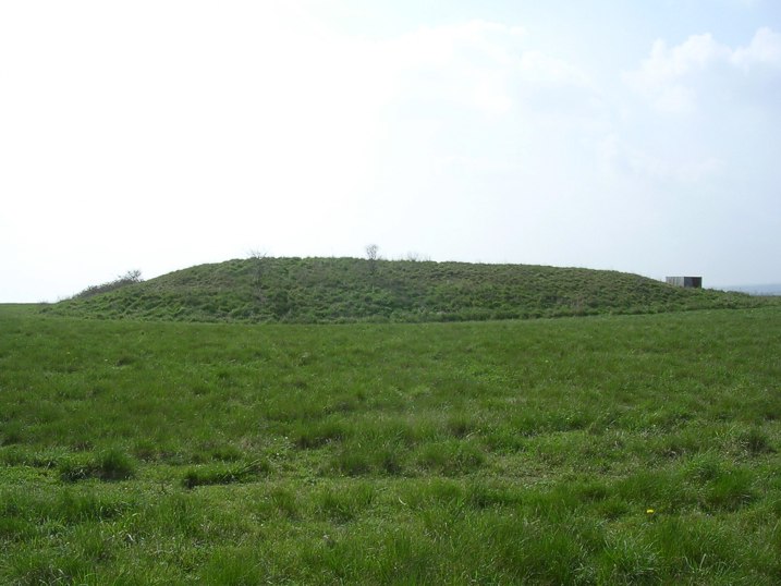
Gussage Down (North) submitted by JimChampion on 5th Apr 2005. April 2005. Looking SW at the long barrow from the bridleway with a lot of glare from the springtime afternoon sun. The midwinter sun would set behind it, possibly of significance to the neolithic designers of the Cursus which runs through this site.
(View photo, vote or add a comment)
Log Text: None
Gussage Down (South)
Date Added: 19th Sep 2010
Site Type: Long Barrow
Country: England (Dorset)
Visited: Yes on 6th Apr 2005

Gussage Down (South) submitted by JimChampion on 6th Apr 2005. April 2005. Looking SW at the Gussage Down southern long barrow from the Jubilee Trail bridleway. The SE end (to the left) is the broadest and the fairly unusual U-shaped ditch is open the the NW end (to the right of the picture). The nearby long barrow which stood within the Dorset Cursus is aligned with this barrow to the NW.
(View photo, vote or add a comment)
Log Text: None
Wor Barrow
Date Added: 19th Sep 2010
Site Type: Long Barrow
Country: England (Dorset)
Visited: Yes on 8th Apr 2005

Wor Barrow submitted by JimChampion on 8th Apr 2005. Looking south at the remains of Wor Barrow. The barrow mound once stood on the flat area enclosed by the excavated ditch, which curves around both ends. The spoil from the 1893-4 excavation has been banked around the ditch, highest (and terraced) on the right of this picture. Across the field to the left, on the other side of the A354 road, is the Bronze Age Oakley Down barrow cemetery. The Wor Barrow would have been very prominent on the landscape when viewed from Oakely Down.
(View photo, vote or add a comment)
Log Text: None
Knowlton Great Barrow
Date Added: 19th Sep 2010
Site Type: Round Barrow(s)
Country: England (Dorset)
Visited: Yes on 9th Apr 2005
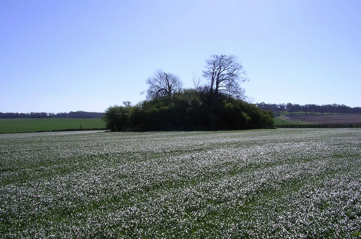
Knowlton Great Barrow submitted by JimChampion on 9th Apr 2005. April 2005. View of the great barrow from the centre of Knowlton Henge: a dark tree-covered island in a sea of shimmering young wheat. The agriculture in this field has completely removed any remains of the barrow's huge outer ditch (over 100m in diameter) but this can be seen as crop marks under suitable conditions.
(View photo, vote or add a comment)
Log Text: None
Oakley Down Barrows
Date Added: 19th Sep 2010
Site Type: Barrow Cemetery
Country: England (Dorset)
Visited: Yes on 9th Apr 2005
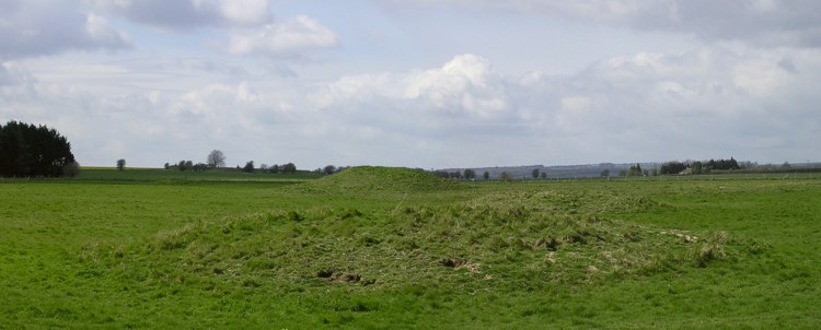
Oakley Down Barrows submitted by JimChampion on 9th Apr 2005. April 2005. A view NW from the Ackling Dyke with round barrows in the Oakley Down cemetery in the foreground and the remains of the Wor long barrow on the horizon (left of the tall round barrow). When the Romans built the Ackling Dyke they drove it straight through the cemetery, over the top of two disc barrows.
(View photo, vote or add a comment)
Log Text: None
Pimperne Long Barrow
Date Added: 19th Sep 2010
Site Type: Long Barrow
Country: England (Dorset)
Visited: Yes on 9th Apr 2005
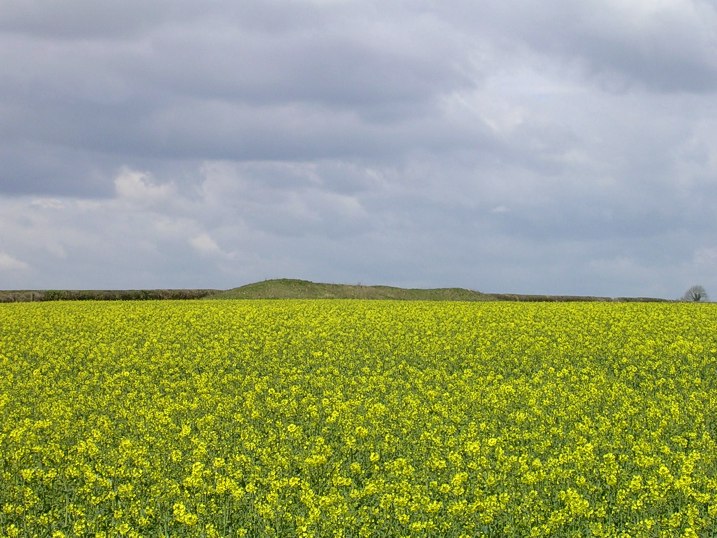
Pimperne Long Barrow submitted by JimChampion on 9th Apr 2005. April 2005. Looking NW at the Pimperne Long Barrow from the A354 roadside. If you are travelling towards Blandford Forum then the barrow is very conspicuous on the right hand side of the road: imagine how eye-catching it was when it was newly built (circa 3000 BCE) and white with chalk.
(View photo, vote or add a comment)
Log Text: None
