Contributory members are able to log private notes and comments about each site
Sites Markj99 has logged. View this log as a table or view the most recent logs from everyone
Kermané Dolmen
Date Added: 2nd Oct 2023
Site Type: Burial Chamber or Dolmen
Country: France (Bretagne:Morbihan (56))
Visited: Yes on 17th Sep 2023. My rating: Condition 3 Ambience 3
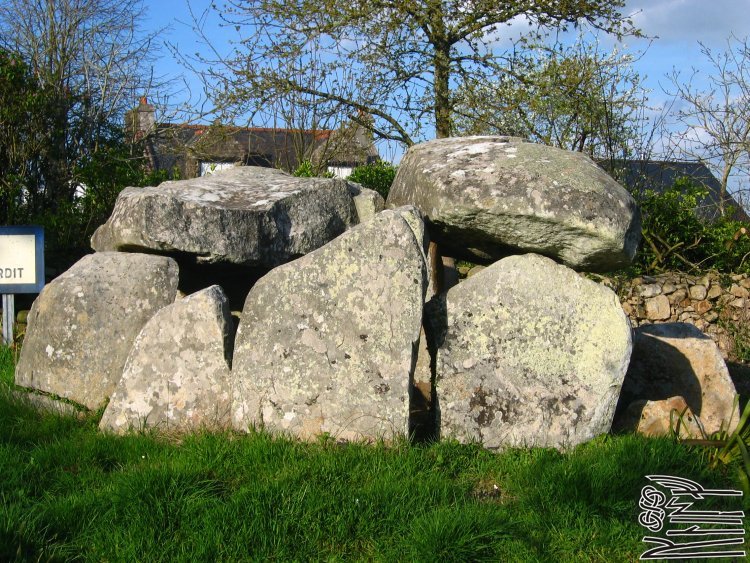
Kermané dolmen submitted by Ogneslav on 25th May 2008. Site in Bretagne: Morbihan (56)
(View photo, vote or add a comment)
Log Text: There is a hidden dolmen c. 450m SW of the Le Chat Noir roundabout on the D781. A cul-de sac signed to Kerganoff is 300m SW of the roundabout. Follow the narrow lane for c. 200m to a dead-end. Dolmen de Kermané is on the left in a private garden. I was limited to taking pictures from outside the fence.
Kermaillard Menhir
Date Added: 27th Sep 2023
Site Type: Standing Stone (Menhir)
Country: France (Bretagne:Morbihan (56))
Visited: Yes on 15th Sep 2023. My rating: Condition 4 Ambience 5 Access 4

Kermaillard menhir submitted by stollentroll on 21st May 2006. Kermaillard menhir, around 4 metres tall. The menhir shows engravings and cup-marks.
(View photo, vote or add a comment)
Log Text: Menhir de Kermaillard is a massive standing stone, sub-rectangular in cross section, measuring c. 1.7m long and 1.2m wide. This dressed pillar rises to a point at c. 4m. There is a square measuring c. 0.6m and a crescent carved in bas-relief on the base of the WSW face. A small axe carved on the left of the square is no longer visible. Proposed carvings on the ENE face are not visible in bright light.
Kerlud Dolmen
Date Added: 26th Sep 2023
Site Type: Burial Chamber or Dolmen
Country: France (Bretagne:Morbihan (56))
Visited: Yes on 14th Sep 2023. My rating: Condition 3 Ambience 4 Access 5
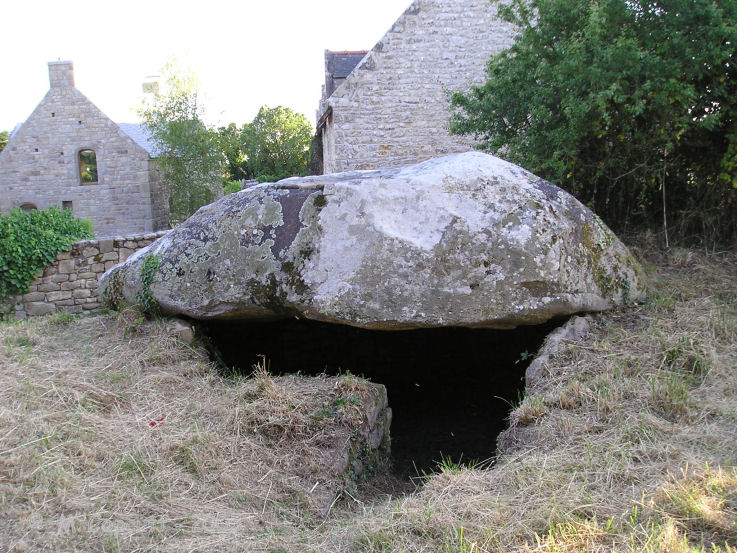
Kerlud dolmen submitted by thecaptain on 27th May 2008. This is a simple chambered dolmen which has been incorporated into the end of a wall behind a farm in the hamlet of Kerlud.
(View photo, vote or add a comment)
Log Text: Dolmen de Kerlud is a ruined monument c. 1km W of Locmariaquer in the small hamlet of Kerlud. Only the massive capstone remains over a chamber reconstructed with dry stone walls.
Kerlescan Tertre and menhir
Date Added: 3rd Oct 2023
Site Type: Standing Stone (Menhir)
Country: France (Bretagne:Morbihan (56))
Visited: Yes on 16th Sep 2023. My rating: Condition 3 Ambience 4 Access 4

Kerlescan Tertre and menhir submitted by LizH on 31st Oct 2007. This stone stands at the west end of the Kerlescan rows, but to the north of them, at the western end of what was once a tumulus.
The small bear (Barnaby) at the bottom is from Hallbankgate school and is making a tour of pre-historic sites!
(View photo, vote or add a comment)
Log Text: The Kerlescan Alignments were one of the few open on my visit to Carnac Alignments. I was able to walk to the W edge of Kerlescan Alignments from where a vague path led W for c. 40m to Kerlescan Menhir.
Kerlescan Alignements
Date Added: 2nd Oct 2023
Site Type: Multiple Stone Rows / Avenue
Country: France (Bretagne:Morbihan (56))
Visited: Yes on 16th Sep 2023. My rating: Condition 3 Ambience 5 Access 4

Kerlescan Alignements submitted by thecaptain on 18th Oct 2004. Kerlescan Alignements, northeast of Carnac, Brittany.
This picture was taken looking east in 1987, when wandering amongst the stones was OK. I think many of them have been fenced off to try and combat erosion these days. I must go back sometime.
(View photo, vote or add a comment)
Log Text: The only alignments open to walk through on my visit were Menec and Kerlescan. Alignements de Kerlescan was the more impressive of the two with taller stones in the rows.
Kergavat Dolmen
Date Added: 7th Oct 2023
Site Type: Burial Chamber or Dolmen
Country: France (Bretagne:Morbihan (56))
Visited: Yes on 18th Sep 2023. My rating: Condition 3 Ambience 3 Access 4
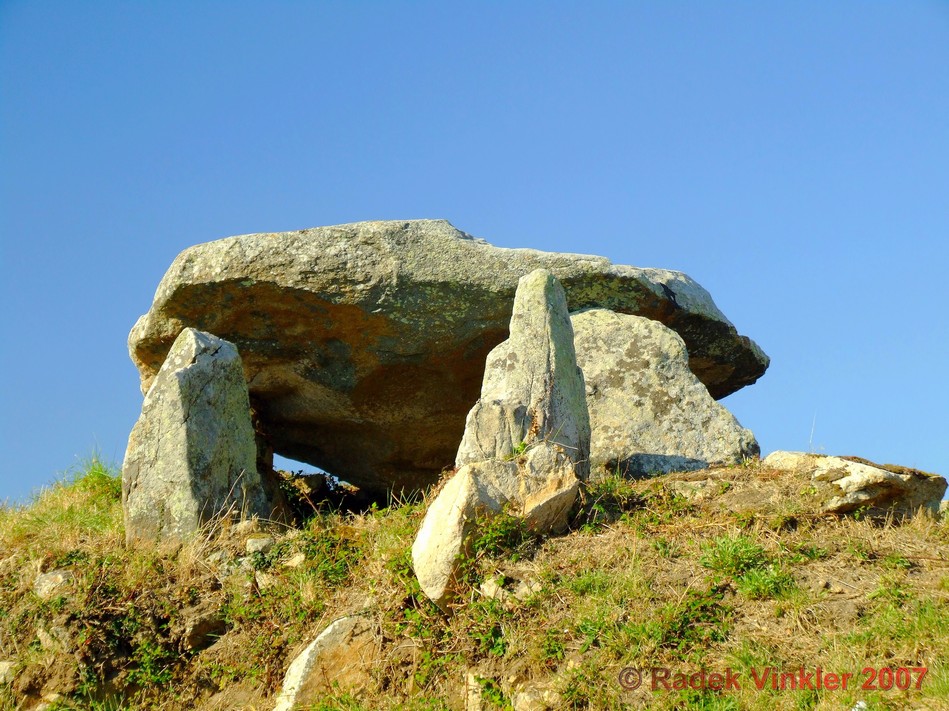
Kergavat dolmen submitted by rw1 on 4th Mar 2008. 09/2007
(View photo, vote or add a comment)
Log Text: Kergavat Dolmen is located perilously close to the D781 on the SE edge of Plouharnel. It is somewhat neglected but still worth a short visit.
Kercadoret Dolmen
Date Added: 2nd Oct 2023
Site Type: Burial Chamber or Dolmen
Country: France (Bretagne:Morbihan (56))
Visited: Yes on 17th Sep 2023. My rating: Condition 3 Ambience 5 Access 3
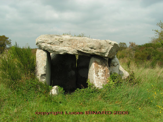
Kercadoret dolmen submitted by binardino on 19th Jun 2006. Site in Bretagne: Morbihan (56)
Kercadoret Dolmen
(View photo, vote or add a comment)
Log Text: Visited 17.09.2Dolmen de Kercadoret is a neglected site in a shrubby wood N of the D781 on the NE edge of Kercadoret. There is a path off the D781 into a field on the NE edge of Kercadoret. Follow round the edge of the wood for c. 80m then follow the wood N for c. 20m to reach a vague path into the wood. Head NW for c. 20 yards through shrubbery to find the hidden dolmen. It is located at 47.58981 -2.9781 if you have a GPS app.
Kensalyre Stone
Date Added: 3rd Apr 2021
Site Type: Standing Stone (Menhir)
Country: Scotland (Isle of Skye)
Visited: Yes on 9th Aug 2011. My rating: Condition 3 Ambience 4 Access 4
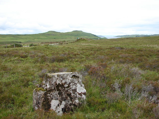
Kensalyre Stone submitted by Andy B on 14th Apr 2010. Not as imposing as the two in Kensaleyre, the stone is much larger. This view is looking back towards Little Loch Snizort
Copyright John Allan and licensed for reuse under the Creative Commons Licence.
(View photo, vote or add a comment)
Log Text: There is a c. 3.5 foot stone in moorland around 50 feet SE of Kensaleyre Cairns, a pair of cairns on the E edge of the A87 to Portree. It seems probable that this stone had a relationship to the nearby cairns. It is listed under Canmore ID 11325 along with Kensaleye Cairns.
Isle Head
Date Added: 21st May 2024
Site Type: Promontory Fort / Cliff Castle
Country: Scotland (Dumfries and Galloway)
Visited: Yes on 3rd Feb 2021. My rating: Condition 3 Ambience 4 Access 4
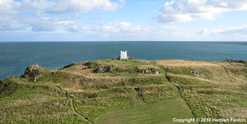
Isle Head submitted by h_fenton on 15th Feb 2011. Isle Head (Isle of Whithorn) Promontory Fort viewed from the north.
Kite Aerial Photograph
16 September 2010 @ 3pm
(View photo, vote or add a comment)
Log Text: It's a short detour to Isle Head fort while visiting St Ninian's Chapel.
Ingle Stone (Ingleston)
Date Added: 15th Aug 2023
Site Type: Natural Stone / Erratic / Other Natural Feature
Country: Scotland (Dumfries and Galloway)
Visited: Yes on 17th Jan 2019. My rating: Condition 5 Ambience 5 Access 3

Ingle Stone (Ingleston) submitted by markj99 on 16th Jun 2019. Ingle Stone, S of Twynholm
(View photo, vote or add a comment)
Log Text: I approached the Ingle Stone from the north because there is no room to park on the minor road running south from Twynholm past Ingleston farm. I parked up at a farm track road end at NX 65830 54067. I followed the track south (past Arden Fort). I headed SSE towards NX 65971 53318 using my GPS to zoom into my target.
Inchmulloch Hill
Date Added: 23rd Jun 2022
Site Type: Standing Stone (Menhir)
Country: Scotland (Dumfries and Galloway)
Visited: Yes on 1st Mar 2022. My rating: Condition 3 Ambience 3 Access 3
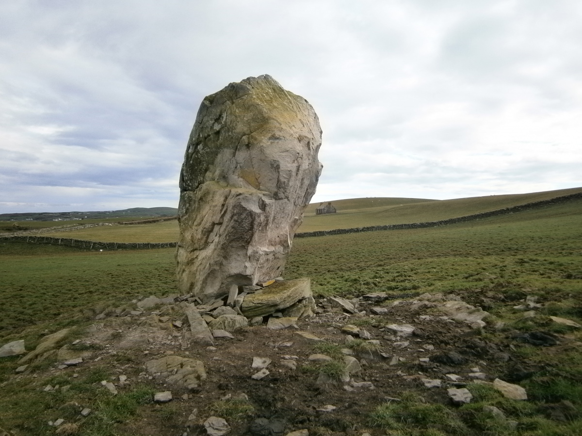
Inchmulloch Hill submitted by markj99 on 23rd Jun 2022. NW Face of Inchmulloch Standing Stone.
(View photo, vote or add a comment)
Log Text: Inchmulloch Hill Standing Stone looks like a large stone which has been erected in modern times. There are two large chock stones on the W base supporting it's vertical position however the standing stone is not earth set. I was somewhat surprised that this stone remains standing.
Idol Stone
Date Added: 19th Dec 2022
Site Type: Rock Art
Country: England (Yorkshire (West))
Visited: Yes on 21st Jan 2009. My rating: Condition 4 Ambience 5 Access 3

Idol Stone submitted by andyb456 on 22nd Nov 2004. This stone is beautiful and need no description.
(View photo, vote or add a comment)
Log Text: The singular markings on the Idol Stone are a must visit for anyone interested in rock art.
Hwylfa’r Ceirw Stone Alignment
Date Added: 22nd Jul 2022
Site Type: Stone Row / Alignment
Country: Wales (Conwy)
Visited: Yes on 18th Apr 2011

Hwylfa’r Ceirw Stone Alignment submitted by LivingRocks on 6th Apr 2005. The double stone row of Hwylfa’r Ceirw, view towards the coast.
(View photo, vote or add a comment)
Log Text: Hwylfa’r Ceirw Stone Alignment was one of my rare accidental finds. While exploring a ruined footprint of a building on Great Orme my eye was drawn to the S Terminus of the stone row. I followed it downhill towards Marine Drive. The majority of the stones in the row are small however it is a significant presence in its landscape.
Howmoor
Date Added: 30th Oct 2022
Site Type: Stone Fort or Dun
Country: Scotland (Dumfries and Galloway)
Visited: Yes on 24th Oct 2022. My rating: Condition 2 Ambience 4 Access 3

Howmoor submitted by markj99 on 26th Oct 2022. Howmoor Dun viewed from N.
(View photo, vote or add a comment)
Log Text: The most prominent aspects of Howmoor Dun are the natural mound and the ditch and rampart defence on the W Arc.
Hound Tor Ring Cairn
Date Added: 17th Sep 2022
Site Type: Ring Cairn
Country: England (Devon)
Visited: Yes on 12th Sep 2022. My rating: Condition 2 Ambience 4 Access 4

Hound Tor Ring Cairn submitted by h_fenton on 23rd Oct 2009. Hound Tor Ring Cairn, with Hound Tor in the background.
29 September 2009
(View photo, vote or add a comment)
Log Text: Hound Tor Kerb Cairn is easily visited at the foot of Hound Tor. The kerb cairn has a continuous kerb from N Arc to S Arc. The central cist has been exposed. The interior of the cairn has been entirely robbed of stones except for S & W Cist Stones.
Hound Tor Enclosure
Date Added: 19th Sep 2022
Site Type: Causewayed Enclosure
Country: England (Devon)
Visited: Yes on 12th Sep 2022. My rating: Condition 5 Ambience 5 Access 4
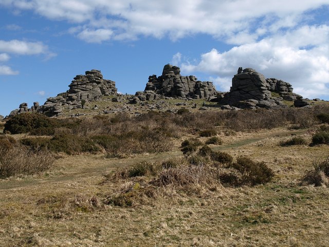
Hound Tor Enclosure submitted by Andy B on 3rd Jul 2011. Hound Tor
From this angle, taken a little way into the moorland from Swallerton Gate, SX7479 : Hound Tor falls into three main stacks.
Copyright Derek Harper and licensed for reuse under the Creative Commons Licence.
(View photo, vote or add a comment)
Log Text: Hound Tor impressive outcrops form a natural enclosure. It is easy to see why ancient people would choose this elevated location as a defensive location.
Hound Tor Deserted Medieval Village
Date Added: 19th Sep 2022
Site Type: Ancient Village or Settlement
Country: England (Devon)
Visited: Yes on 12th Sep 2022. My rating: Condition 2 Ambience 4 Access 4

Hound Tor Deserted Medieval Village submitted by markj99 on 19th Sep 2022. High Street of Hound Tor Medieval Village viewed from WSW.
(View photo, vote or add a comment)
Log Text: Hound Tor Medieval Village lies SE of Hound Tor. The footprints of the buildings are well preserved however the layout is somewhat confusing. There are four longhouses surrounded by ancillary houses and barns.
Hough Cairn
Date Added: 26th Nov 2022
Site Type: Cairn
Country: Scotland (Isle of Tiree)
Visited: Yes on 27th Aug 2018. My rating: Condition 2 Ambience 4 Access 3
Hough Cairn submitted by markj99 on 5th Nov 2020. Hough Cairn looking WNW across Hough Stone Circle SSW.
(View photo, vote or add a comment)
Log Text: Hough Cairn is one of several sites located in rough pasture at Hough. Individually they are not impressive, but collectively they form a significant group.
Hough - SSW
Date Added: 26th Nov 2022
Site Type: Stone Circle
Country: Scotland (Isle of Tiree)
Visited: Yes on 27th Aug 2018. My rating: Condition 2 Ambience 4 Access 3
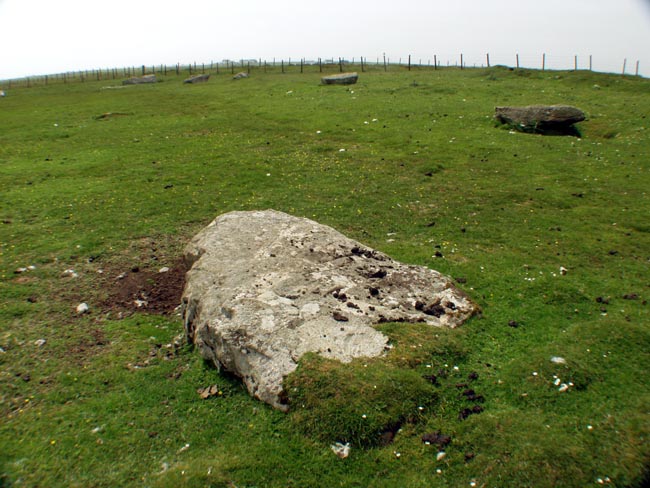
Hough - SSW submitted by Tom_Bullock on 9th Jun 2004. A pick of images from the CD-ROM
(View photo, vote or add a comment)
Log Text: Hough SSW is one of several sites located in rough pasture at Hough. Individually they are not impressive, but collectively they form a significant group.
Hough - NNE
Date Added: 26th Nov 2022
Site Type: Stone Circle
Country: Scotland (Isle of Tiree)
Visited: Yes on 27th Aug 2018. My rating: Condition 2 Ambience 4 Access 3

Hough - NNE submitted by Tom_Bullock on 25th Feb 2005. Photo used by kind permission of Tom Bullock. More details of this location are to be found on his Stone Circles and Rows CD-ROM.
(View photo, vote or add a comment)
Log Text: Hough NNE is one of several sites located in rough pasture at Hough. Individually they are not impressive, but collectively they form a significant group.
