Contributory members are able to log private notes and comments about each site
Sites Markj99 has logged. View this log as a table or view the most recent logs from everyone
Boscawen-Un Hedge
Date Added: 29th May 2021
Site Type: Standing Stone (Menhir)
Country: England (Cornwall)
Visited: Yes on 4th Feb 2019. My rating: Condition 3 Ambience 3 Access 5

Boscawen-Un Hedge submitted by enkidu41 on 3rd Mar 2004. This conical stone lies to the E of the Boscawen-un Stone Circle along the side of a lane. It is 2.3m high SW 4174 2770
(View photo, vote or add a comment)
Log Text: There is a lay-by c. 250 yards NW of Boscawen Noon farm. The unusually triangular standing stone is embedded into the hedge on the R side of the farm track.
Boscawen-Un Field
Date Added: 29th May 2021
Site Type: Standing Stone (Menhir)
Country: England (Cornwall)
Visited: Yes on 4th Feb 2019. My rating: Condition 4 Ambience 4 Access 3
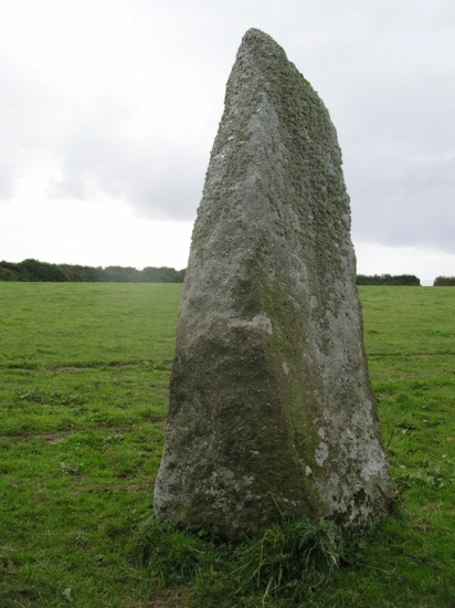
Boscawen-Un Field submitted by Unknown on 27th Oct 2003. Menhir near Boscawen Un
(View photo, vote or add a comment)
Log Text: This impressive c. 9 ft tall pillar stands c. 500 yards NE of Boscawen-Un Stone Circle on the edge of a field.
Dun Bornaskitaig
Date Added: 28th May 2021
Site Type: Broch or Nuraghe
Country: Scotland (Isle of Skye)
Visited: Yes on 27th Jan 2012. My rating: Condition 2 Ambience 4 Access 3
Dun Bornaskitaig submitted by hamilton on 17th Sep 2014. The scant remnants of Dun Bornaskitaig sit atop this eminence, less then 100 metres east of the coastline at Kilmuir on the Trotternish peninsula.
(View photo, vote or add a comment)
Log Text: The remains of the broch on Dun Bornaskitaig are mostly hidden under a grassy bank up to c. 4 feet high round the perimeter of the dun. There are several building constructed from the broch's stones in the vicinity of the dun.
Borve Stone Row
Date Added: 28th May 2021
Site Type: Stone Row / Alignment
Country: Scotland (Isle of Skye)
Visited: Yes on 9th Aug 2011. My rating: Condition 3 Ambience 4

Borve Stone Row submitted by Andy B on 24th Nov 2010. Borve Stone Row taken in about 1997
(View photo, vote or add a comment)
Log Text: There is a slight curve to the 3 stones in this row lending some weight to the argument that they were once part of a stone circle. The construction of a road through a stone circle could have occurred in the past.
Borve Standing Stones
Date Added: 28th May 2021
Site Type: Standing Stones
Country: Scotland (Barra and Vatersay)
Visited: Yes on 28th Jun 2011. My rating: Condition 3 Ambience 4 Access 4
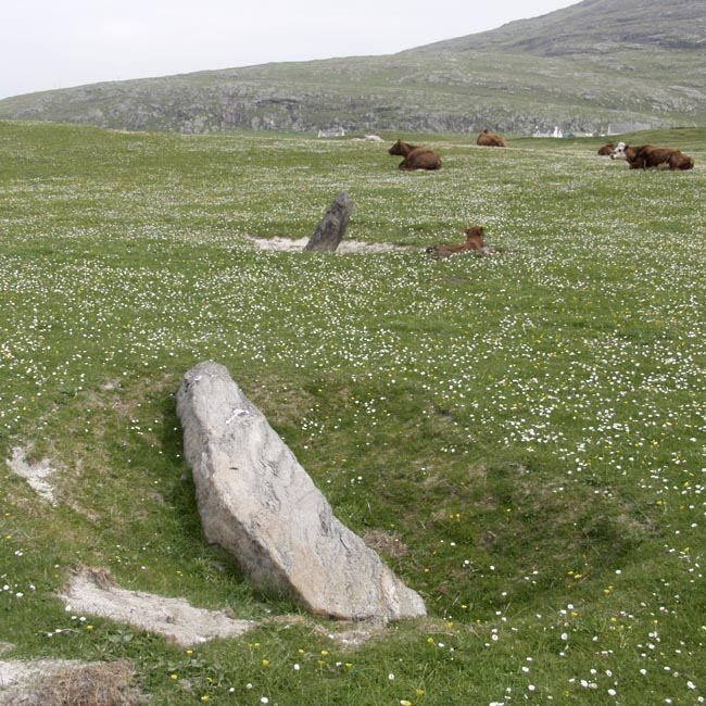
Borve Standing Stones submitted by Tom_Bullock on 27th Feb 2005. Photo used by kind permission of Tom Bullock. More details of this location are to be found on his Stone Circles and Rows CD-ROM.
(View photo, vote or add a comment)
Log Text: Borve Standing Stones are close to a beach track at the small community of Borve. Dun Bharpa is accessed via Borve, a worthwhile detour up to a large almost intact cairn.
Borgarvirki
Date Added: 28th May 2021
Site Type: Promontory Fort / Cliff Castle
Country: Iceland
Visited: Yes on 15th Nov 2015. My rating: Condition 3 Access 4
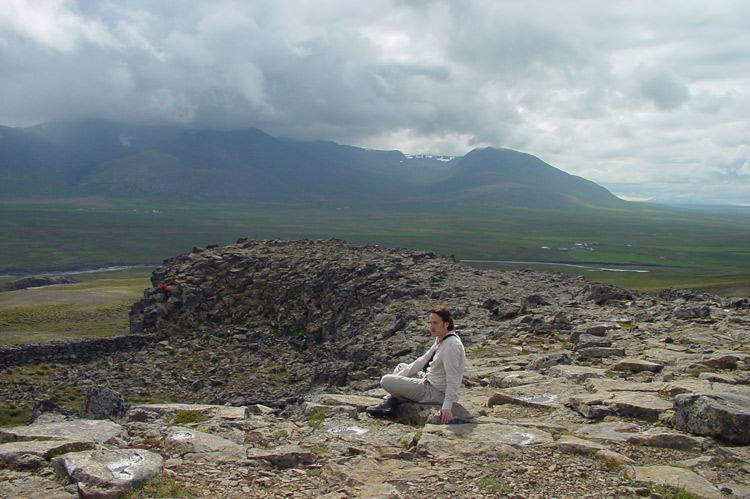
Borgarvirki submitted by KaiHofmann on 15th Apr 2010. Site in Iceland
(View photo, vote or add a comment)
Log Text: I was fortunate to visit Borgarvirki Fort on the cusp of Winter, a fresh layer of snow adding atmosphere to an impressive site. Although my visit predated Game of Thrones it seems to me that Borgarvirki could easily have been transported from the icy wastes beyond The Wall.
Knocknocher stone pair
Date Added: 28th May 2021
Site Type: Standing Stones
Country: Scotland (Dumfries and Galloway)
Visited: Yes on 15th Sep 2018. My rating: Condition 3 Ambience 4 Access 3
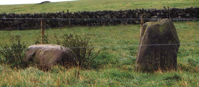
Knocknocher stone pair submitted by PaulM on 30th Oct 2002. Knocknocher stone pair
teutfuryeeww Three legged support
This stone pair (one of which has sadly fallen) may also go by the name of Boreland or Clugston Burn. They are now safely penned in behind wire - the fence posts can be seen from the lane that runs to the south. At this point there is a gate for the brave which opens easily. NGR: NX35235808
(View photo, vote or add a comment)
Log Text: Knocknocher stone pair's proximity to White Cairn, Boreland may be significant. They are not in themselves impressive but they may have been waymarkers to the cairn. The stones are fenced off to protect them from cattle. Beef cattle are usually present in the field so caution should be exercised.
Spittal Croft cairn
Date Added: 28th May 2021
Site Type: Cairn
Country: Scotland (Dumfries and Galloway)
Visited: Yes on 15th Sep 2018. My rating: Condition 2 Ambience 3 Access 4

Spittal Croft cairn submitted by PaulM on 30th Oct 2002. Spittal Croft cairn
This stoney cairn can be seen at NX35665800 just NE of a property called Spittal Croft (the cairn maybe called something different locally). It is located at a road junction. It is one of a cluster of monuments in the area including another cairn (White Cairn) a fort and a stone pair.
(View photo, vote or add a comment)
Log Text: It is easy to park at a road junction just beyond Spittal Croft Cairn. The low circle in the flat pasture is not spectacular but it was obviously more impressive before its near destruction. Sometimes it is better to to have a footprint of a cairn than an over-reconstructed monument.
Boreland
Date Added: 28th May 2021
Site Type: Chambered Cairn
Country: Scotland (Dumfries and Galloway)
Visited: Yes on 19th Sep 2020. My rating: Condition 3 Ambience 5 Access 3

Boreland submitted by kelpie on 1st Oct 2003. NX 40580 68989
This relatively untouched horned long cairn lies in the woods north of Newton Stewart. This photo shows the two portal stones with the cairn heaped behind them.
(View photo, vote or add a comment)
Log Text: Boreland Cairn features on a path round Knockman Wood located to the N of Minigaff. Despite its relative isolation the cairn was being robbed until 1882 when it was protected. The cairn is best visited in Spring or Autumn to avoid the ferns.
Bombie 3
Date Added: 25th May 2021
Site Type: Rock Art
Country: Scotland (Dumfries and Galloway)
Visited: Yes on 24th May 2021. My rating: Condition 3 Ambience 5 Access 3
Bombie 3 submitted by SolarMegalith on 13th Oct 2016. A general view of Bombie 3 panel (photo taken on September 2016).
(View photo, vote or add a comment)
Log Text: Bombie 3 is easier to find than Bombie 2 due to its proximity to the pond fenced off in the NE corner of the field. Bombie 3 is located beside a gorse bush c. 10 yards N from the SW corner of the electric fence round the pond. The rock art panel is at the base of a gorse bush within several yards of the fence. There is a large cup and multiple rings marking centrally placed on a roughly triangular panel. Smaller fainter cup and ring markings in the bottom apexes are covered in turf. I left them covered to protect them.
Bombie 2
Date Added: 25th May 2021
Site Type: Rock Art
Country: Scotland (Dumfries and Galloway)
Visited: Yes on 24th May 2021. My rating: Condition 3 Ambience 5 Access 3
Bombie 2 submitted by SolarMegalith on 13th Oct 2016. Cup-and-ring marks on Bombie 2c panel (photo taken on September 2016).
(View photo, vote or add a comment)
Log Text: Bombie 2 is located on a gorse covered ridge on a SSW-NNE Axis at NX 72517 49733. This is different from the listed grid reference, a mistake copied from Canmore ID 64436. It is difficult to find in rough terrain broken up by beef cattle. The Bombie 2 panels were largely hidden under turf on my recent visit.
Castlecreavie Settlement
Date Added: 25th May 2021
Site Type: Ancient Village or Settlement
Country: Scotland (Dumfries and Galloway)
Visited: Yes on 24th May 2021. My rating: Condition 3 Ambience 4 Access 4
Castlecreavie Settlement submitted by SolarMegalith on 4th Oct 2016. Outline of the rampart in the NE part of the settlement (photo taken on September 2016).
(View photo, vote or add a comment)
Log Text: Castlecreavie Settlement is situated on the road to Castlecreavie Farm between Kirkcudbright and Dundrennan. There is room to park at NX 72424 49258, c. 500 yards up the narrow road to Castlecreavie Farm. There is a style leading up to Castlecreavie Settlement. The natural hillock has an enclosure measuring c. 75 yards NE-SW and 40 yards NW-SE. There are remains of a c. 4 feet rampart on the SW and NE of the enclosure. There are steep slopes all round except for the SW which slopes away at a shallow angle. There is a prominent terrace from c. 12 to 15 feet wide round the settlement, except on the SW side.
Boleigh
Date Added: 21st May 2021
Site Type: Souterrain (Fogou, Earth House)
Country: England (Cornwall)
Visited: Yes on 23rd Mar 2013. My rating: Condition 3 Ambience 5 Access 4

Boleigh submitted by ocifant on 3rd Oct 2004. The entrance to the fogou.
(View photo, vote or add a comment)
Log Text: Rosemerryn house owners were kind enough to allow access to Boleigh Fogou. It was my first visit to a subterranean site but I enjoyed it immensely.
Milton Hill
Date Added: 20th May 2021
Site Type: Standing Stones
Country: Scotland (Dumfries and Galloway)
Visited: Yes on 7th Feb 2009. My rating: Condition 4 Ambience 5 Access 3

Milton Hill submitted by cosmic on 7th Oct 2004. Along the Line
(View photo, vote or add a comment)
Log Text: There is something magical about a perfectly matched pair of standing stones. The Blairbuy Stones are almost perfectly matched in shape and size. They could be the portal to another world.
Blairbuy 5
Date Added: 20th May 2021
Site Type: Rock Art
Country: Scotland (Dumfries and Galloway)
Visited: Yes on 12th Nov 2011. My rating: Condition 3 Ambience 5 Access 3
Blairbuy 5 submitted by SolarMegalith on 6th Sep 2015. Blairbuy 5 - cup with single ring is the only motif on this panel (photo taken on June 2015).
(View photo, vote or add a comment)
Log Text: Blairbuy 5 is a small deep-cut cup and ring marking on a rock ledge in whins c. 200 yards ESE from the summit cairn of Fell of Barhullion. (Canmore ID 62770)
Blairbuy 3
Date Added: 20th May 2021
Site Type: Rock Art
Country: Scotland (Dumfries and Galloway)
Visited: Yes on 12th Nov 2011. My rating: Condition 3 Ambience 5 Access 3
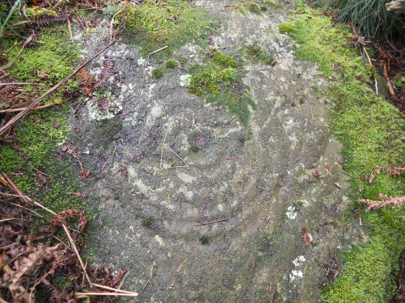
Blairbuy 3 submitted by markj99 on 27th Mar 2019. Blairbuy 3, 5 concentric rings clearly visible.
(View photo, vote or add a comment)
Log Text: Blairbuy 3 was hidden by whins however it was a large cup & 6 rings marking. It was less worn than the Rock Art lying prone in the fields probably due to it's sheltered location.
Blairbuy 2
Date Added: 20th May 2021
Site Type: Rock Art
Country: Scotland (Dumfries and Galloway)
Visited: Yes on 27th Aug 2011. My rating: Condition 3 Ambience 5 Access 3

Blairbuy 2 submitted by markj99 on 27th Mar 2019. Blairbuy 2, 2 cup marks top right hand side of rock panel.
(View photo, vote or add a comment)
Log Text: The cup and ring markings on the panel were faint but there were several large cup markings visible.
Bladnoch
Date Added: 20th May 2021
Site Type: Standing Stone (Menhir)
Country: Scotland (Dumfries and Galloway)
Visited: Yes on 15th Sep 2018. My rating: Condition 4 Ambience 3 Access 5

Bladnoch Standing Stone submitted by PaulM on 29th Oct 2002. This standing stone is marked on the OS Explorer Map 311 (Wigtown, Whithorn & The Machars) and can be found in the drystone wall flanking the A714 and directly opposite the house called Ashleigh in Bladnoch. The whisky distillery is only a short stagger away.
NGR: NX 423542.
(View photo, vote or add a comment)
Log Text: The stone lies opposite no 18 in Bladnoch main street. It is an irregular stone prominent above the regular wall. It's true nature can be seen from the field side of the wall where the breadth of the stone is visible. There is an entrance into the field c. 75 yards W of the standing stone.
Bencallen Hill
Date Added: 19th May 2021
Site Type: Chambered Cairn
Country: Scotland (South Ayrshire)
Visited: Yes on 19th May 2021. My rating: Condition 2 Ambience 5 Access 3
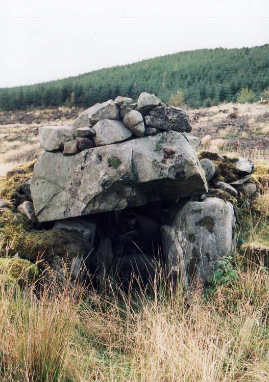
Bencallen Hill submitted by PaulM on 29th Oct 2002. Shiel Bridge/Bencallen chambered tomb
Good navigation is needed to find this cairn as the landscape is pretty featureless (NX33779440). Luckily for us the conifers had been recently cleared. There is parking (just) but the lane is very quiet. I dived up the slope and headed in the vague general direction but struck lucky.
Another strange site as the cairn cover has been robbed for drystone walls which all seemed to have been built to hem in the chamber or perhaps as sheepfolds. All t...
(View photo, vote or add a comment)
Log Text: Bencallen Cairn lies c. 3.75 miles E from Barr Village in S Ayrshire. It is difficult to get to but the splendid isolation of this site more than compensates. Only one large chamber of the cairn remains built into the N wall of a sheepfold. Presumably the stones from Bencallen Cairn were used in the construction of the sheepfold. The ground round about and inside the sheepfold has been deforested so it is rough and rutted.
Billy Marshall's Cave
Date Added: 16th May 2021
Site Type: Cave or Rock Shelter
Country: Scotland (Dumfries and Galloway)
Visited: Yes on 16th May 2009. My rating: Condition 5 Ambience 5 Access 1
Billy Marshall's Cave submitted by markj99 on 14th Sep 2020. Entrance to Billy Marshall''s Cave.
(View photo, vote or add a comment)
Log Text: It has been more than ten years since I last visited Billy Marshall's Cave. I wonder how many people have visited it since then. There was a geocache box in it so maybe that would have increased its popularity.
