Contributory members are able to log private notes and comments about each site
Sites Marko has logged. View this log as a table or view the most recent logs from everyone
Croft Ambrey
Date Added: 22nd Jul 2015
Site Type: Hillfort
Country: England (Herefordshire)
Visited: Yes on 10th Jul 2015. My rating: Condition 3 Ambience 2 Access 3
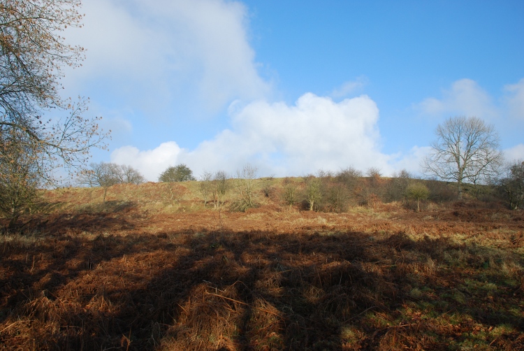
Croft Ambrey submitted by jfarrar on 10th Jan 2009. Southern Ramparts from outside the fort
(View photo, vote or add a comment)
Log Text: Walked up to the hillfort during a visit to Croft Castle (National Trust).
A leaflet was available from the N.T giving directions plus a number of 'points of interest' ie gateways,site of a rectangular structure (granary?),site of a Romano-British structure (Temple/Sanctuary?) but due to the time of year the bracken obscured just about everything,rendering much of the hillfort unrecognisable as such.
I will revisit during the winter months when the 6' plus vegetation has died back!!
Also couldn't locate the spring on this vist - maybe next time.
Pen-Twyn
Date Added: 23rd Jan 2017
Site Type: Hillfort
Country: Wales (Monmouthshire)
Visited: Visited (still working on) on 16th Aug 2015. My rating: Condition 4 Ambience 4 Access 3
Log Text: Half a hill fort is better than none! I intended to visit this site whilst on holiday nearby.Was out on another walk and saw the hillfort,but as i wasn't expecting to visit as soon i hadn't got my notes with me. - Fatal,as i thought that what was actualy a central bank was the South East limit of the fort.Only realised later that i'd missed the chance to see about half of the defences.
However,the half of the hillfort i did see was worth the climb up from Oldcastle.The North West rampart was under bracken but was still impressive (as was the central bank).A modern track runs right alongside the South Western rampart.The North Eastern side is defended by the natural steep slope of Hatterall Hill.
Clodock Inscribed Stone
Date Added: 9th Feb 2021
Site Type: Carving
Country: England (Herefordshire)
Visited: Yes on 18th Aug 2015. My rating: Condition 4 Ambience 4 Access 5

Clodock Inscribed Stone submitted by coin on 3rd Mar 2019. The inscribed stone at Clodock.
(View photo, vote or add a comment)
Log Text: None
Kilpeck church
Date Added: 25th Oct 2021
Site Type: Early Christian Sculptured Stone
Country: England (Herefordshire)
Visited: Yes on 22nd Aug 2015. My rating: Condition 4 Ambience 5 Access 5
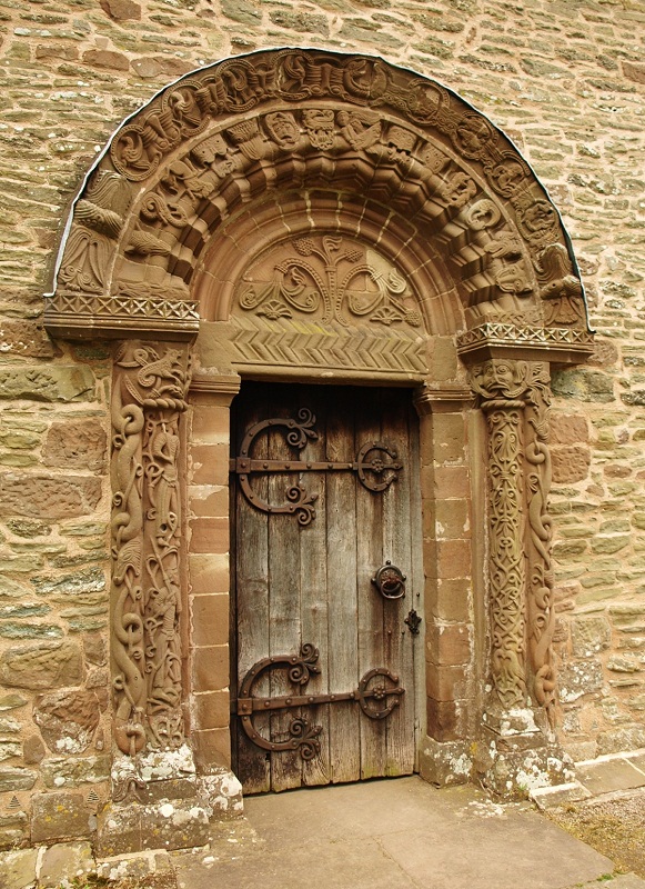
Kilpeck church submitted by bat400 on 21st Nov 2018. The entry of Kilpeck Chruch. A wooden porch (not original) that covered this doorway for a period of time it thought to have helped protect the carvings.
Photo by bat400, 2014.
(View photo, vote or add a comment)
Log Text: None
Carreg Cennen Cave
Date Added: 12th Dec 2018
Site Type: Cave or Rock Shelter
Country: Wales (Carmarthenshire)
Visited: Yes on 17th Aug 2016. My rating: Condition 4 Ambience 3 Access 2

Carreg Cennen Cave submitted by postman on 16th Oct 2014. Looking down upon the covered walkway to the cave, which is under the stonework lower right, and showing the cave and the castle's superb position.
(View photo, vote or add a comment)
Log Text: None
Dolmen dit la Table des Fées
Date Added: 23rd Jan 2017
Site Type: Burial Chamber or Dolmen
Country: France (Nord:Pas-de-Calais (62))
Visited: Yes on 11th Sep 2016. My rating: Condition 3 Ambience 4 Access 5
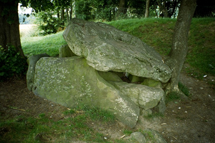
Dolmen dit la Table des Fées submitted by greywether on 30th Jun 2005. Dolmen dit la Table des Fées
(View photo, vote or add a comment)
Log Text: Stumbled accross this site by accident.
Was visiting a nearby castle and saw on one of the walls an old plan of ''Monument Celtique De Fresnicourt''.
The plan showed what had supposeddly been 4 dolmens linked by standing stones.In the central area was an eliptical stone circle radiating out from the Northern Dolmen.
The plan was undated.All very fanciful and possibly the delusions/wishful thinking of some Victorian(?) era antiquarian.
The Fresnicourt dolmen was well signposted from the village and was situated right by the side of the road.Without doubt the easiest site i've ever visited.
If there were ever another 3 dolmens plus standing stones,then i never saw any sign of them.
Castlerigg
Date Added: 23rd Jan 2017
Site Type: Stone Circle
Country: England (Cumbria)
Visited: Yes on 4th Oct 2016. My rating: Condition 5 Ambience 4 Access 5

Castlerigg submitted by wayland on 23rd May 2016. The Carles of Castlerigg shot by fire light.
(View photo, vote or add a comment)
Log Text: None
Beacon Hill (Leicestershire)
Date Added: 23rd Jan 2017
Site Type: Hillfort
Country: England (Leicestershire and Rutland)
Visited: Yes on 1st Nov 2016. My rating: Condition 2 Ambience 2 Access 4
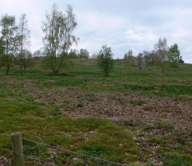
Beacon Hill (Leicestershire) submitted by Andy B on 11th Jul 2010. The Bronze Age `Fort` at Beacon Hill is at least 3000 years old.
Copyright Mat Fascione and licensed for reuse under the Creative Commons Licence.
(View photo, vote or add a comment)
Log Text: None
Dinas Bran
Date Added: 26th Feb 2017
Site Type: Hillfort
Country: Wales (Denbighshire)
Visited: Yes on 24th Feb 2017. My rating: Condition 2 Ambience 3 Access 3
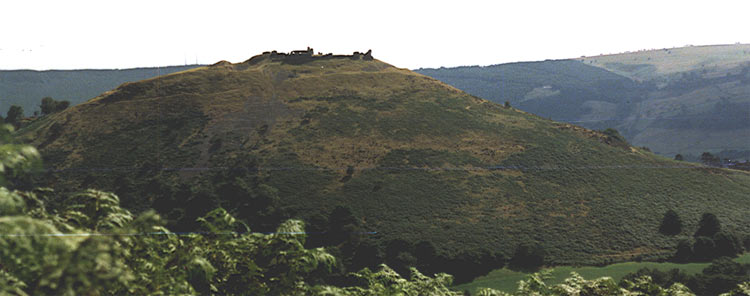
Dinas Bran submitted by blingo on 6th Jun 2004. SJ 223430 near Llangollen showing the hill you have to climb to reach the top!
Photo taken from top of hill at SJ 212445
(View photo, vote or add a comment)
Log Text: None
Berth Hill
Date Added: 4th Apr 2017
Site Type: Hillfort
Country: England (Staffordshire)
Visited: Yes on 2nd Apr 2017. My rating: Condition 3 Ambience 4 Access 3
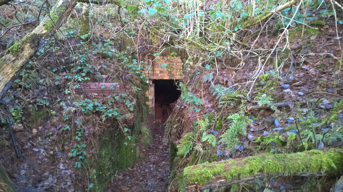
Berth Hill submitted by HarryTwenty on 2nd Oct 2022. Victorian aqueduct built into the eastern side of the hillfort to carry water from the spring to the hall and village of Maer (January 2022)
(View photo, vote or add a comment)
Log Text: It's been 3 years since i was last here and this time there was a lot more vegetation to contend with!
On my previous visit it was possible to walk around pretty much the whole of the inner rampart.
This time i reckon that less than 50% of the inner rampart was walkable.Lot's of bracken,fallen trees and unforgiving briars to contend with.
The fine inturned entrance on the S.W side now has large holly tree spoiling part of it.Also,tyre tracks were visible in the entrance on this visit.
With a bit of maintenance this could easily be (in my eyes) the jewel in ithe Crown of Staffordshire hillforts.
The Wrekin
Date Added: 1st Aug 2017
Site Type: Hillfort
Country: England (Shropshire)
Visited: Yes on 6th May 2017. My rating: Condition 4 Ambience 3 Access 3
The Wrekin submitted by TimPrevett on 2nd Jan 2005. Lookin to the North East, between the outer and inner ramparts of The Wrekin.
The path enters the inturned ramparts to the central area; the trig point and toposcope sit upon a Bronze Age Cairn, which is hardly in evidence.
Another, more slight rampart is visible to the left of the picture, before the hill becomes more rounded.
See main entry - click on the blue text to the left of the picture for more information.
(View photo, vote or add a comment)
Log Text: None
Ysbyty Cynfyn
Date Added: 1st Aug 2017
Site Type: Stone Circle
Country: Wales (Ceredigion)
Visited: Yes on 27th Jul 2017. My rating: Condition 4 Ambience 3 Access 5

Ysbyty Cynfyn Stone Circle submitted by Johnny on 10th Oct 2001. Ysbyty Cynfyn "Stone Circle" (SN 752 791)
This readily accessible site is situated alongside the A4120 running south from Ponterwyd towards Devil's Bridge. The circle is not marked as an antiquity on recent OS maps but the church itself is easily found. Despite recent dissenting opinion, it has generally been accepted that this is an example of the early Christian Church adopting an ancient site, in this case an embanked Bronze Age stone circle, presumably in an attempt to "des...
(View photo, vote or add a comment)
Log Text: None
Devil's Punch Bowl
Date Added: 11th Dec 2019
Site Type: Natural Stone / Erratic / Other Natural Feature
Country: Wales (Ceredigion)
Visited: Yes on 27th Jul 2017. My rating: Condition 5 Ambience 5 Access 4

Devil's Punch Bowl submitted by Postman on 10th Sep 2018. Looking over the side of the bridge to the punchbowl, right next to the viewing stage.
(View photo, vote or add a comment)
Log Text: None
Bradgate Hunt's Hill Stone
Date Added: 19th Mar 2018
Site Type: Standing Stone (Menhir)
Country: England (Leicestershire and Rutland)
Visited: Yes on 17th Mar 2018. My rating: Condition 5 Ambience 3 Access 4

Bradgate Hunt's Hill Stone submitted by Stefan Spencer on 11th Feb 2004. Bradgate Hunt's Hill Stone
Information required please. Where is this?
(View photo, vote or add a comment)
Log Text: Debate over whether this site is a genuine standing stone or something some rogue Boy Scouts erected (if so then i hope they got a badge for it?!).
Very easy to find : 2 to 3 minute walk behind the toilet block as described elsewhere!
Bishop's Wood
Date Added: 11th Sep 2018
Site Type: Hillfort
Country: England (Staffordshire)
Visited: Couldn't find on 30th Mar 2018
Log Text: On the scant info available i tried for the best part of 2 hours to locate the site! Using the map references I could find absolutely nothing on the ground ie bank's, ditches etc.
On the way back through the woods and at a different location/map coordinates I did see what could possibly have been the re entrant gully and 2 rather silted up ditches but the rest of the topography didn't fit the Hill Fort description I had. So overall I have to say that I didn't find it!
If anyone out there has any further info as to where exactly to locate this fort - please let me know.
Devil's Ring and Finger
Date Added: 31st Mar 2018
Site Type: Holed Stone
Country: England (Staffordshire)
Visited: Yes on 30th Mar 2018. My rating: Condition 2 Ambience 3 Access 3

Devil's Ring and Finger submitted by Paul Morgan on 25th Jul 2001. This site is all that remains of a long cairn. The Devil's Ring is a perforated septal stone similar to the one at the Bridestones in Cheshire. The Finger was, perhaps, a portal stone. Neither are in their original position.
Located near Mucklestone, Staffordshire and marked on OS map 127.
(View photo, vote or add a comment)
Log Text: Easier to find than I thought. The fact that the stones had been moved from their original location to the field boundary some time in the distant past kind of reflected in the lack of ambience but was still worth the walk to it.. Pleased to say that the barbed wire fences mentioned on other members site logs are now 'down'.
Berry Ring
Date Added: 4th Apr 2018
Site Type: Hillfort
Country: England (Staffordshire)
Visited: Yes on 1st Apr 2018. My rating: Condition 2 Ambience 3 Access 4

Berry Ring submitted by TimPrevett on 7th Mar 2007. Between the western ramparts, accessible from the adjoining lane, looking north.
(View photo, vote or add a comment)
Log Text: The closest hill fort to home and therefore one that i had never previously visited!
Good remains of the inner rampart ditch and counterscarp bank on the west side - just a few steps away from the modern lane. There is a suggestion that the lane might have been the site of another ditch but i've read that this theory is now discredited.
Also good remains of the rampart on the North side.
No remains left now of the entrance (South side) This was widened out some years ago when marl was being extracted from the interior of the fort. A modern house now spans the gap!
The mid point of the Western defences are also breached by a cottage- How the hell did these 2 propertIes get planning permission?! Shame on those who let them build on an ancient monument.
There is a spring fed pond in the North West corner.From where there are excellent views over to the Wrekin and its hill fort.
Mam Tor
Date Added: 7th Sep 2018
Site Type: Hillfort
Country: England (Derbyshire)
Visited: Yes on 18th Aug 2018. My rating: Condition 3 Ambience 3 Access 4
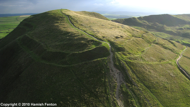
Mam Tor submitted by h_fenton on 27th Sep 2010. An almost horizontal kite aerial photograph of Mam Tor viewed from roughly north.
9 September 2010 @ 5.42pm
(View photo, vote or add a comment)
Log Text: None
Symonds Yat Fort
Date Added: 7th Sep 2018
Site Type: Hillfort
Country: England (Gloucestershire)
Visited: Yes on 30th Aug 2018. My rating: Condition 3 Ambience 2 Access 5
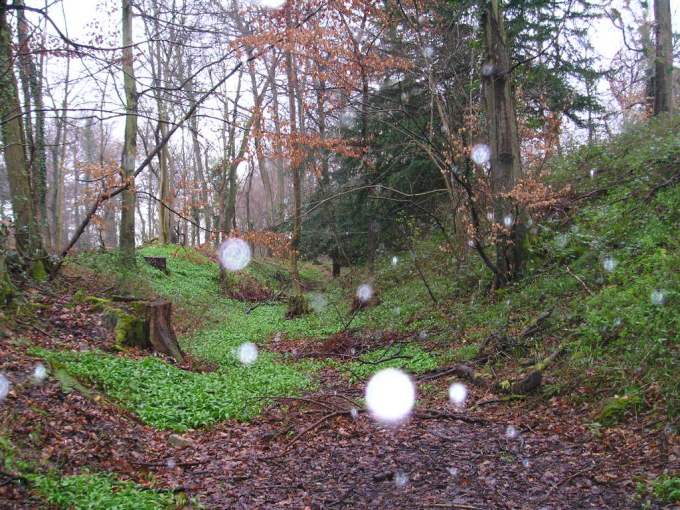
Symonds Yat Fort submitted by TheCaptain on 5th Apr 2004. Symonds Yat Fort, Symonds Yat, Gloucestershire, SO563157
Iron age hillfort on the headland of Symonds Yat Rock, high above a complete U Bend in the river Wye.
This is a view of the eastern end of the inner ditch and bank, the defended headland being to the right.
This is a smashing place to visit on a nice day, of which this was most definately NOT one.
(View photo, vote or add a comment)
Log Text: None
Old Oswestry Fort
Date Added: 1st Nov 2018
Site Type: Hillfort
Country: England (Shropshire)
Visited: Yes on 27th Oct 2018. My rating: Condition 4 Ambience 3 Access 5

Old Oswestry Fort submitted by Bladup on 16th Jan 2016. Old Oswestry, western side looking north.
(View photo, vote or add a comment)
Log Text: None
