Contributory members are able to log private notes and comments about each site
Sites TheCaptain has logged. View this log as a table or view the most recent logs from everyone
High Bridestones (Yorks)
Date Added: 4th Dec 2024
Site Type: Stone Circle
Country: England (Yorkshire (North))
Visited: Yes on 17th Sep 2024. My rating: Condition 3 Ambience 4 Access 4

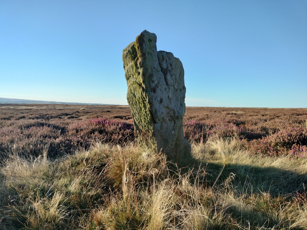
High Bridestones (Yorks) submitted by TheCaptain on 2nd Dec 2024. At the lower, northwestern end of the main alignment is another fairly large stander.
OK, I'm off
(View photo, vote or add a comment)
Log Text: After a day walking the beautiful coastline between Runswick bay and Staithes, I had an hour or two of beautiful sunshine left in the day, and made the decision to drive over onto the moor for a quick look for the Bridestones, of which I have vague memories from 27 years ago. In this weather, three upright stones standing can clearly be seen, so I walk over to the tallest, more than 6 feet tall. At this point, three other large stones can be seen flat to the ground along with several smaller ones. My memory tells me they were in a circle, but that doesn't really look to be the case to me today. To the northwest, slightly down the hill, can be seen several other standers in a rough line, and walking down along the row the I come to another group of several stones, but this time nothing more than a few feet tall. There are many other smaller stumps and flat stones can be seen before progressing down to another fairly large stander. Back at the top, there is another short stander off to the southeast, and what appear to be several moor, but which turn out to be sheep munching! Its all a bit of a mess, but I dont think this should be given stone circle status, it's more like a stone row to me. A megalithic disaster indeed.
High Brotheridge
Date Added: 10th Jun 2021
Site Type: Misc. Earthwork
Country: England (Gloucestershire)
Visited: Yes on 31st May 2021. My rating: Condition 2 Ambience 3 Access 3
High Brotheridge submitted by 4clydesdale7 on 7th Jul 2014. Inturned Banks at S Entrance
(View photo, vote or add a comment)
Log Text: Walking a Cooper's Hill Circuit of the Cotswold Way from Cranham, and passed around the western edge of this massive hilltop settlement with various bits and pieces of defensive ramparts to be seen.
High Willhays kerb cairn
Date Added: 19th Aug 2024
Site Type: Ring Cairn
Country: England (Devon)
Visited: Yes on 2nd Aug 2024. My rating: Condition 2 Ambience 4 Access 2

High Willhays kerb cairn submitted by Bladup on 5th Oct 2014. High Willhays prehistoric kerb cairn with the modern cairn behind on top of the Tor.
(View photo, vote or add a comment)
Log Text: From Fordsland Ledge its relatively easy going up to High Willhays, but in a bit of a mist at times which makes me slightly concerned about navigation further on when there will be no obvious trackway. Hard to figure out what exactly this is. There are several side set slabs standing proud just to the east of the top outcrop with its marker cairn on top. It is hard to tell whether these are the remains of a large kerb, or perhaps an internal structure, as in some views it looks to be two parallel rows of slabs.
High Willhays North
Date Added: 19th Aug 2024
Site Type: Ring Cairn
Country: England (Devon)
Visited: Yes on 2nd Aug 2024. My rating: Condition 3 Ambience 4 Access 2

High Willhays North submitted by TheCaptain on 19th Aug 2024. A stitched together panorama of the semi circular tor top cairn on the northern summit of High Willhays. It looks a bit like a semi circular retaining bank for a pool these days. The southern, actual, top of High Willhays (and southern England) beyond.
(View photo, vote or add a comment)
Log Text: Now heading north across the indistinct top of High Willhays towards Yes Tor, I keep an eye open for what we have marked as a ring cairn, which I find positioned adjacent to one of the rock outcrops at the northern top of High Willhays. It seems to be a sort of ring cairn combined with a tor top cairn like that on Showery Tor on Bodmin Moor. It looks a bit like a semi circular retaining bank for a pool.
Higher White Tor stone row
Date Added: 30th Apr 2022
Site Type: Multiple Stone Rows / Avenue
Country: England (Devon)
Visited: Would like to visit
Higher White Tor stone row submitted by cazzyjane on 9th Jan 2013. Higher White Tor Stone row. Looking down towards Longaford Tor.
(View photo, vote or add a comment)
Hiscocks Hill barrow
Date Added: 8th Feb 2022
Site Type: Round Barrow(s)
Country: England (Hampshire)
Visited: Yes on 2nd Feb 2022. My rating: Condition 2 Ambience 3 Access 3

Hiscocks Hill barrow submitted by TheCaptain on 8th Feb 2022. Remains of a round barrow on Hiscocks Hill on Fritham Plain Forest heathland.
(View photo, vote or add a comment)
Log Text: Walk with friends in the New Forest over heathland through an old bombing range, hunting down a few tumuli. Before we got to the (closed) pub at Fritham, I took a small detour to hunt down what is marked as tumulus on my map.
Hoar Moor (E)
Date Added: 18th Sep 2010
Site Type: Standing Stone (Menhir)
Country: England (Somerset)
Visited: Yes on 4th Apr 2007
Hoar Moor (E) submitted by thecaptain on 4th Apr 2007. Hoar Moor standing stone, at Porlock Post, Exmoor.
Seen here looking north east
(View photo, vote or add a comment)
Log Text: None
Hoar Stone at Duntisbourne
Date Added: 29th Oct 2019
Site Type: Chambered Tomb
Country: England (Gloucestershire)
Visited: Yes on 23rd Aug 2017

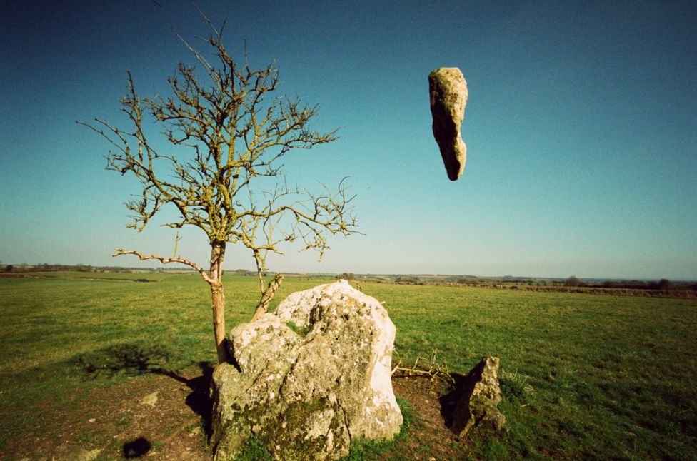
Hoar Stone at Duntisbourne submitted by TheCaptain on 23rd Aug 2017. "Seven years ago photographer David Quentin began capturing surreal, alien-like scenes of rocks falling from the sky at locations across the UK. It all started when the London-based photographer threw a stone into the air and took a picture of it to see how it looked..."
See more at this article
Photo Credit: David Quentin
(View photo, vote or add a comment)
Log Text: None
Hoaroak 1
Date Added: 18th Sep 2010
Site Type: Multiple Stone Rows / Avenue
Country: England (Devon)
Visited: Yes on 30th May 2010
Hoaroak 1 submitted by TheCaptain on 30th May 2010. This is a nice little setting of stones, mostly on open grassland, making it easy to see and find!
Most of the stones are less than 18 inches long, and fallen, or else just stubs of stone still fast in the ground. Only one stone really stands proudly near the centre of the setting.
(View photo, vote or add a comment)
Log Text: None
Hoaroak Hill
Date Added: 29th Oct 2019
Site Type: Standing Stones
Country: England (Devon)
Visited: Yes on 9th Mar 2011
Hoaroak Hill submitted by TheCaptain on 9th Mar 2011. I couldn’t find anything of this, in a very swampy area. There is a nice tree and a couple of very active springs here in this delightful place.
(View photo, vote or add a comment)
Log Text: None
Hoaroak stones
Date Added: 29th Oct 2019
Site Type: Standing Stones
Country: England (Somerset)
Visited: Yes on 21st Feb 2011
Hoaroak stones submitted by TheCaptain on 21st Feb 2011. After a long while searching around, I found a couple of stones which looked like they might be placed in position, although now broken and fallen.
(View photo, vote or add a comment)
Log Text: None
Hobajons Cross
Date Added: 18th Sep 2010
Site Type: Standing Stone (Menhir)
Country: England (Devon)
Visited: Yes on 6th Aug 2004

Hobajons Cross submitted by thecaptain on 6th Aug 2004. Hobajons Cross. This relatively large stone is part of the Butterdon Hill row, and has a simple cross carved into it on the western face. It appears to be a part of the original alignment, adapted for more recent use as a marker for ancient tracks crossing the moor.
(View photo, vote or add a comment)
Log Text: None
Hoccombe Hill (E)
Date Added: 18th Sep 2010
Site Type: Multiple Stone Rows / Avenue
Country: England (Devon)
Visited: Yes on 30th Jul 2007

Hoccombe Hill (E) submitted by TheCaptain on 30th Jul 2007. One of the stones almost lost within the heather on the uphill slope.
A very distinctive stone this.
(View photo, vote or add a comment)
Log Text: None
Hoccombe Hill (W)
Date Added: 18th Sep 2010
Site Type: Standing Stones
Country: England (Devon)
Visited: Yes on 26th Jun 2007

Hoccombe Hill (W) submitted by TheCaptain on 26th Jun 2007. The stones run up the slope, but are not in a straight line, in fact it’s difficult to describe the shape, a sort of lightning flash, or perhaps a sort of very long thin diamond. The southern, downhill three are still standing.
(View photo, vote or add a comment)
Log Text: None
Holme II
Date Added: 21st Jun 2024
Site Type: Timber Circle
Country: England (Norfolk)
Visited: Yes on 10th Jun 2024. My rating: Condition 2 Ambience 4 Access 2

Holme II submitted by dodomad on 16th Apr 2023. This is what remains of Holme II in 2023:
Tom writes: After reading Seahenge by Francis Pryor I finally got to Holme Beach on a low tide. Stunning.
Photo by Tom Charlton @TomCharlton25 on Twitter, reposted with permission - glad I did as the original is now gone
(View photo, vote or add a comment)
Log Text: After many years, and a fair bit of planning, I got to visit the site of Seahange. It needed a significantly low tide, and a long walk with no features to aim for. It was also a complete unknown as to whether any of the timbers would still be there, and not covered by the sands and mud. I started from the pay car park at Holme, near the golf course, and followed the well marked and made coast path to the north then east, through the marshes and sand dunes. Whern I got to near where I thought the site was, I started looking for the signboard, but it had been knocked over so was not easy to find. I then tried to get down onto the beach, which was not easy with cliffs in the dunes and fences, so I retraced my steps back for a fair old way until I could get down onto the beach, before heading back east to the area of the site. After a fair bit of searching around, near to where it is marked on our map, I first saw a pole and stump sticking up, but nothing else. I wondered whether this was a marker for the site of the original Seahenge now removed. Walking in the wet mud and sand further to the east, I some dark shapes. Is this it? I walked over, and indeed it was a sector of timber stumps poking above the water. Further looking, and there were some more sectors, generally under pools, with a few other stumps showing above the sands, which would have made a circle about 15 metres diameter. Fantastic, and well worth the effort. I noticed that there were a few large timbers on their sides nearby, and many other odd stumps. Nearby were a couple of places with arrangements of stumps showing above the sands, are these remnants of other structures. There are a couple of much more modern linear timber structures heading directly towards the sea from the shore, arranged in pairs, and when speaking to a local, he told me that these were constructed by the army and used as devices to move targets up and down the beach, for training the gunners and tanks that were there at the time. These can be used to give a good indication of where the site is.
Holme II
Date Added: 21st Aug 2024
Site Type: Timber Circle
Country: England (Norfolk)
Visited: Yes on 13th Jun 2024. My rating: Condition 2 Ambience 4 Access 2

Holme II submitted by dodomad on 16th Apr 2023. This is what remains of Holme II in 2023:
Tom writes: After reading Seahenge by Francis Pryor I finally got to Holme Beach on a low tide. Stunning.
Photo by Tom Charlton @TomCharlton25 on Twitter, reposted with permission - glad I did as the original is now gone
(View photo, vote or add a comment)
Log Text: Went for a walk around the marshes from Thornham, and ended up walking out along the coast path to the north and west. I noticed that there were signposts to "the site of Seahenge". Anyways, I just kept going, past all sorts of interesting wildlife including spoonbills, and up to the Norfolk Wildlife Trust's Holme Dunes visitor centre, which was closing. Found myself drawn down onto the beach, and saw that it was quite close to the position of Seahenge, and was drawn to wander towards it. As I got there, I was looking for the post which I think marks the site of Seahenge, all still under water. But the tide was going out, and slowly things came into view. Now knowing where it all is, I headed back to Seahenge 2, and noted a couple of timbers poking through the waves, so I waited. Slowly more was revealed, but much less than a few days ago, the sand now right up over the inland side, leaving just the tops of a few of the major sector I had previously seen. I stayed for ages as the site was slowly uncovered. When you know where it is, its remarkably easy to find, and also so much easier to walk to from the east at Thornham rather than the west from Holme. In fact, along the coast path on top of the seawall, it would be possible to push a wheelchair, and only half an hour from the public parking. This said, it is possible to park at the Wildlife centre. I took a three little words position from the centre of the circle; garlic clockwork mole. TF 71234 45246
Holmhead stone circle
Date Added: 29th Oct 2019
Site Type: Modern Stone Circle etc
Country: Scotland (Aberdeenshire)
Visited: Yes on 18th Dec 2018

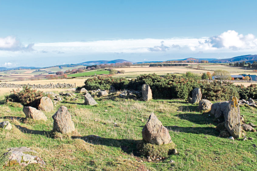
Holmhead stone circle submitted by TheCaptain on 18th Dec 2018. Newly discovered Recumbent Stone Circle near Holmhead farm, in the parish of Leochel-Cushnie in Aberdeenshire.
image from https://www.eveningexpress.co.uk/fp/news/local/historic-stone-circle-discovered-at-north-east-farm/
(View photo, vote or add a comment)
Log Text: None
Holne Moor
Date Added: 29th Oct 2019
Site Type: Multiple Stone Rows / Avenue
Country: England (Devon)
Visited: Yes on 21st Nov 2010
Holne Moor submitted by TheCaptain on 21st Nov 2010. At the southeastern end, in a lowpoint before the ground rises again, there seems to be a single, fairly large triangular shaped stone placed across the central or northern row, which may once have been a blocking stone marking the proper end of the monument.
(View photo, vote or add a comment)
Log Text: None
Holne Ridge 2
Date Added: 24th Apr 2020
Site Type: Cairn
Country: England (Devon)
Visited: Yes on 5th Oct 2010
Holne Ridge 2 submitted by TheCaptain on 5th Oct 2010. Holne Ridge cairn 2 looking west.
I didn’t think I was going to be able to find this as the area it’s in is all covered by fern and bracken, but it was quite obvious once I got near.
(View photo, vote or add a comment)
Log Text: None
Holne Ridge 5
Date Added: 24th Apr 2020
Site Type: Cairn
Country: England (Devon)
Visited: Yes on 5th Oct 2010
Holne Ridge 5 submitted by TheCaptain on 5th Oct 2010. Holne Ridge cairn 5.
This is a fairly large and prominent round cairn, about 14 metres diameter and 1.5 metres tall. However, I wasn't going to look too closely, as there were some stroppy looking guard cows staring me down!
(View photo, vote or add a comment)
Log Text: None
