Contributory members are able to log private notes and comments about each site
Sites TheCaptain has logged. View this log as a table or view the most recent logs from everyone
Hvar Island
Date Added: 18th Sep 2010
Site Type: Ancient Village or Settlement
Country:
Visited: Yes on 30th Sep 2004
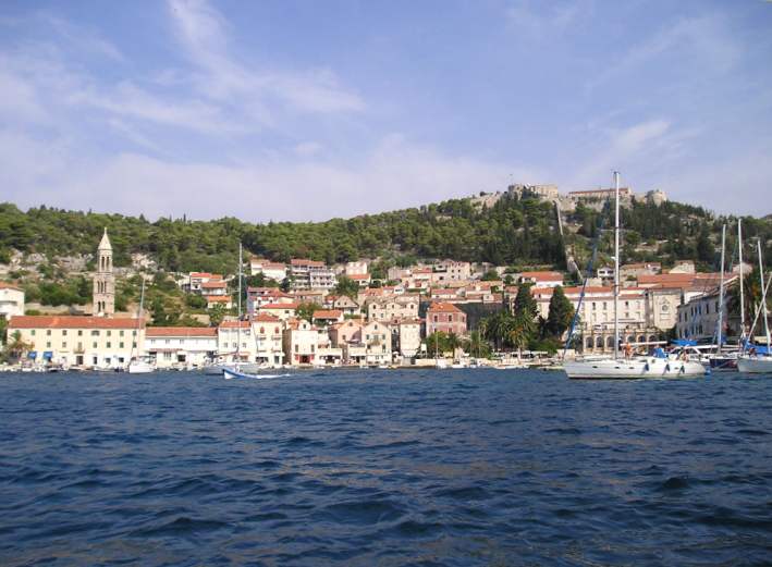
Hvar Island submitted by thecaptain on 30th Sep 2004. The lovely island of Hvar is situated at an ancient crossroads of searoutes through the Adriatic Sea, and as such has many traces of history.
This is Hvar town seen from its harbour.
(View photo, vote or add a comment)
Log Text: None
Hwasun dolmens
Date Added: 29th Oct 2019
Site Type: Burial Chamber or Dolmen
Country: South Korea
Visited: Yes on 28th Feb 2014
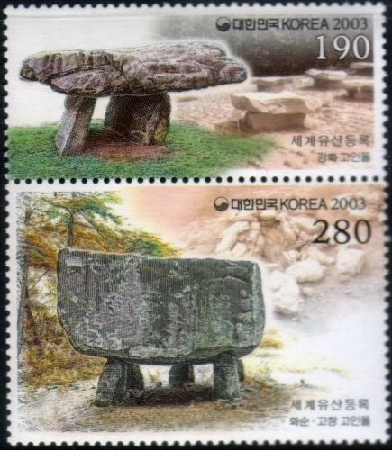
Hwasun dolmens submitted by theCaptain on 28th Feb 2014. One of the Hwasun dolmens in South Korea as featured on a postage stamp
(View photo, vote or add a comment)
Log Text: None
Hypogée de Bonnias
Trip No.205 Entry No.202 Date Added: 29th Nov 2020
Site Type: Passage Grave
Country: France (Provence:Bouches-du-Rhône (13))
Visited: Couldn't find on 22nd Sep 2005
Log Text: I could find no way to this hypogae, as everywhere has lots of big high security fences.
Hypogee du Castelet
Trip No.205 Entry No.199 Date Added: 26th Nov 2020
Site Type: Passage Grave
Country: France (Provence:Bouches-du-Rhône (13))
Visited: Yes on 22nd Sep 2005. My rating: Condition 3 Ambience 1 Access 5
Hypogee du Castelet submitted by thecaptain on 25th Apr 2007. It is about 20 - 25 metres long, 2 metres deep and 2 - 3 metres wide, and covered with large slabs, but very overgrown.
(View photo, vote or add a comment)
Log Text: Beside the road between Arles and Fontvieille, this hypogae has a little signpost, from where the monument can be found in the bushes and marsh to the side of the road. It's unbearably mosquito infested and I couldn’t get away quick enough.
There is a trench carved into the rock, which is now filled with boggy water, and there is a nice entrance ramp down at the west end. It is probably about 20 metres long, 2 metres deep and up to 2 metres wide, and covered with large slabs. Just inside the trench is a carved entrance stone. I cant stay here any longer, I have got to get away, as I am being bitten to death.
Iasos
Date Added: 1st Dec 2010
Site Type: Ancient Village or Settlement
Country: Turkey
Visited: Yes on 16th Sep 2002. My rating: Condition 3 Ambience 5 Access 4
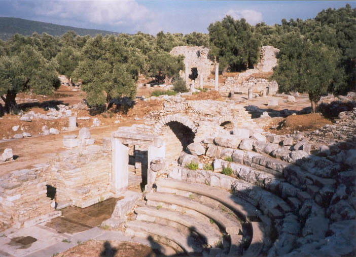
Iasos submitted by TheCaptain on 30th Nov 2010. Turbintorium ruins at Ancient Iasos
(View photo, vote or add a comment)
Log Text: None
Ibsley Common barrows
Date Added: 18th Sep 2010
Site Type: Barrow Cemetery
Country: England (Hampshire)
Visited: Yes on 6th May 2006

Ibsley Common barrows submitted by thecaptain on 6th May 2006. On the western edge of the New Forest plateau above the river Avon is this fine disc barrow with splendid views in all directions.
This is the view towards the northeast.
(View photo, vote or add a comment)
Log Text: None
Île Carn cairn
Trip No.203 Entry No.514 Date Added: 27th May 2020
Site Type: Chambered Cairn
Country: France (Bretagne:Finistère (29))
Visited: Saw from a distance on 20th Jun 2005. My rating: Access 2
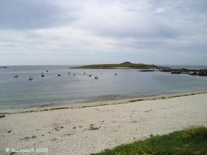
Île Carn cairn submitted by thecaptain on 15th Jun 2006. Île Carn, just off the northwestern coast of Brittany.
Unfortunately, when I was passing here the tide was not fully out, and rising, so I could not get out onto the little island with its massive and spectacular cairn.
I tried stopping nearby for the night, which would have let me get out onto the island next morning, but the local campsite was closed and deserted, and I had worldly needs, so had to move on elsewhere, still hoping to come back the next morning.......
(View photo, vote or add a comment)
Log Text: Just offshore is this little island which can be reached a low tide, with a massive cairn containing three dolmenic chambers. There are also some WW2 gun emplacements and lookouts which spoil it a bit. The cairn is massive, and looks like its been quarried into, and from the shore the entry to one of the chambers can be seen. Its a pity I cannot get out to have a look. Should I borrow a boat ?
Île Carn cairn
Trip No.214 Entry No.10 Date Added: 27th May 2020
Site Type: Chambered Cairn
Country: France (Bretagne:Finistère (29))
Visited: Yes on 16th Apr 2014. My rating: Condition 4 Ambience 5 Access 3

Île Carn cairn submitted by theCaptain on 18th Apr 2014. Re-incarnation from the left side chamber, Easter 2014.
(View photo, vote or add a comment)
Log Text: Just offshore from the bay of Porsguen in the community of Ploudalmézou at the northwestern point of Finisterre, Brittany, lies a small island, which can be walked to at low tide from the mainland. A large part of this small island is made up of a massive and remarkable round cairn which contains three dolmenic chambers. The outer round cairn is about 30 metres in diameter, and perhaps still almost 10m in height. It seems to have only been recognised that an ancient cairn was here in the late 19th century, which was further recognised by others in the early 20th century, with a description of 1925 mentioning the presence of an anthropomorphic stele, 1.75m in height.
During the course of the second world war, construction of a lookout post and gun battery on the island broke through into the monument and revealed the presence of the southern chamber. During the following ten years degradation of the monument became rapid, accelerated by clandestine excavations, until in 1954 a rescue plan was put into place under the direction of P-R Giot. Following an interruption, further excavations occurred between 1964 and 1967, which showed that the construction was made using local materials, mostly granite stones with occasional use of megalithic slabs. Several phases of construction were revealed.
The initial construction was a circular chamber of diameter approx 3.5 metres with an entrance passageway from one side of the chamber thus making a q shape, leading in from the southeast. The structure is all of dry stone walling technique except for the entrance passage which is covered with megalithic slabs. The chamber is roofed with a circular corbelled structure which remains intact to this day. Drystone walling had been used to block off the chamber at both extremities of the passageway. The whole of this was enclosed in a circular cairn. Carbon dating has been used to suggest the structure dates back to as long as 4700BC.
The second construction was the addition of a second chamber to the south, with a rectangular plan, and long entrance passageway approx 5 metres in length to the southeast. Carbon dating has been used to suggest this structure dates back to perhaps 4500BC.
Further construction followed with the addition of a third tomb to the northern side of the first, within which are two conjoined chambers, the southern of which is perhaps double the size of the northern, which has a couple of large megalithic slabs used in its construction. Dating of this structure has been used to show a possible date of as far back as 3900 BC or more recently of 2000BC, suggesting a possible long term use of this particular structure.
Following these three cairns, a fourth stage of construction was to possibly make a single large rectangular cairn covering the three adjacent structures. This was then probably followed by a fifth construction stage of an approximately 30 metre diameter circular structure with a facing wall, up to a metre in height surrounding the whole thing, and this blocking off all three chambers.
Within the central chamber were found several small vases and other crescent shaped items which have become eponymously named in the Carn style, along with several pearls and flint tools. The southern chamber revealed more pots including a single small vase of just 5cm diameter, but of similar styling, whilst the northern chamber revealed a splendid 10cm diameter flask and some fine polished flint items, and some fragments of red ochre.
Fabulous
Ile Carn menhir
Trip No.214 Entry No.9 Date Added: 27th May 2020
Site Type: Standing Stone (Menhir)
Country: France (Bretagne:Finistère (29))
Visited: Yes on 16th Apr 2014. My rating: Condition 1 Ambience 4 Access 3
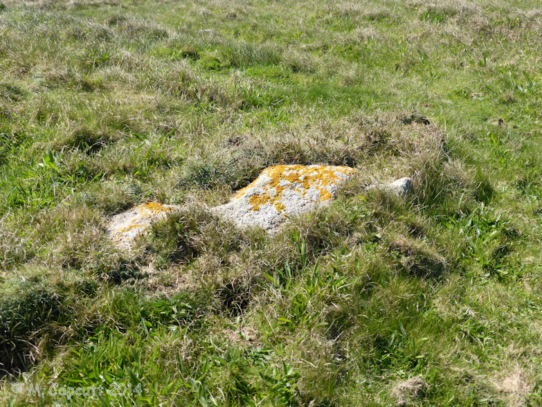
Ile Carn menhir submitted by theCaptain on 9th May 2014. I read somewhere that a menhir was reported on this island, but has become missing.
So, before we went for a look at the cairn, I had a brief look all over the rest of the island, and just behind one of the ruined concrete look out positions is a large long stone laying flat to the ground and mostly now buried, which would have made a perfect menhir, probably just below 2 metres tall, fitting my memory of the description.
(View photo, vote or add a comment)
Log Text: I read somewhere that a menhir was once reported on this island, but has become missing. So, before we went for a look at the cairn, I had a brief look all over the rest of the island, and just behind one of the ruined concrete look out positions is a large long stone laying flat to the ground and mostly now buried, which would have made a perfect menhir, probably just below 2 metres tall.
Ile Guénioc
Trip No.203 Entry No.519 Date Added: 28th May 2020
Site Type: Chambered Tomb
Country: France (Bretagne:Finistère (29))
Visited: Saw from a distance on 21st Jun 2005. My rating: Condition 5 Ambience 5 Access 1
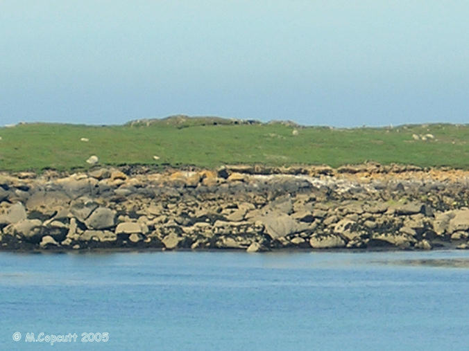
Ile Guénioc submitted by thecaptain on 17th Jun 2006. This island, which is difficult to get to, has on it three massive cairns with their multitude of chambers and dolmens within them.
This is the best picture I could get on my little camera, taken on full zoom from Ile Tariec, which can be walked to at very low tide.
(View photo, vote or add a comment)
Log Text: Just offshore from Presqu'ile Ste-Marguerite near the town of Landéda, and due west of Ile Tariec, can be seen Ile Guénioc (Ile Gaignog). This island, which is difficult to get to, has on it three massive cairns with their multitude of chambers and dolmens within them. In order to get here a boat is needed, and I think that landing on the island is controlled, so I am not going to manage it now, as there is nobody about with a boat who I can try and persuade!
Through my binoculars from where I am sat on Ile Tariec it looks superb. The southernmost cairn seems to have about half a dozen entrances in the eastern side and facing towards me, but it isn't a very high cairn. The middle cairn is even larger, but it is slightly obscured by a rise in the land in front of it. Several large dolmenic structures can be seen, with slabs of rock in places. The northern cairn is even higher, and looks to have about 4 entrances.
I feel that I really need to get out onto the island to have a proper look. I must come back one day with a small boat. Oh well, the tide has turned half an hour ago, I'd better start making my way back, I don't want to be stuck out on this little island for the next ten hours !
Île Longue tumulus
Trip No.203 Entry No.333 Date Added: 4th May 2020
Site Type: Chambered Tomb
Country: France (Bretagne:Morbihan (56))
Visited: Saw from a distance on 10th Jun 2005
Île Longue tumulus submitted by TheCaptain on 11th Jun 2020. Plan of the tumulus taken from "Il faut qu’une tombe soit ouverte ou fermée" by Charles-Tangay Le Roux
(View photo, vote or add a comment)
Log Text: I took a walk out to the Pointe de Penbert, from where the entrance to the Golfe de Morbihan can clearly be seen, and all the many islands within the gulf. It is a smashing day with a good breeze, and lots and lots of sailing boats are out having fun. There's a cracking tacking duel going on between two large single handed craft as I was writing. It all looks lots and lots of fun.
Just offshore can be seen the islet of Er Lannic, with its double cromlech. Many of the stones stand proud of the island, and indeed the sea, where these half submerged circles are situated, and can clearly be seen from here. Just beyond that is Gavrinis, with its large cairn and entrance overlooking the whole scene. The entrance seems to be looking directly towards me, although in reality it is probably looking a bit more towards the east. The cairn is clearly visible, looking pale against the dark background of a pinewood. A boat trip of people has just landed on the island for the guided visit to the cairn, with its magnificent carvings.
A bit further away to the west is Isle Longue, with its large tumulus at the south end of the island visible, and beyond that is Locmariaquer, with all its sites.
Île Melon Dolmen
Trip No.203 Entry No.501 Date Added: 27th May 2020
Site Type: Burial Chamber or Dolmen
Country: France (Bretagne:Finistère (29))
Visited: Saw from a distance on 20th Jun 2005. My rating: Condition 3 Ambience 4 Access 2
Île Melon dolmen submitted by rw1 on 6th Mar 2008. 09/2007
(View photo, vote or add a comment)
Log Text: This is frustrating. There is only 15 metres of water between me and the island from where I sit, but the tide is coming in and the island is not going to get any nearer. The dolmen is on top of the island and looks a nice one, its capstone sitting on at least four support stones. There are also at least two menhirs further down to the south of the island, and looking towards the shore. Perhaps a swim is needed !
Île Melon grand menhir
Date Added: 29th Oct 2019
Site Type: Standing Stone (Menhir)
Country: France (Bretagne:Finistère (29))
Visited: Yes on 10th Feb 2019
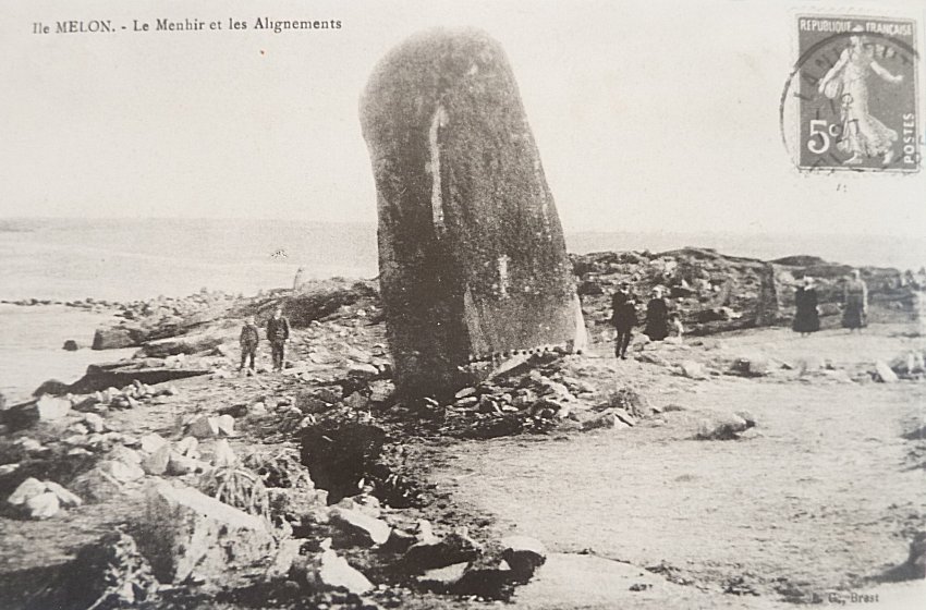
Île Melon grand menhir submitted by TheCaptain on 10th Feb 2019. The huge menhir which once stood on Ile Melon. It was destoyed on 2nd March 1942.
(View photo, vote or add a comment)
Log Text: None
Île Melon menhirs
Trip No.203 Entry No.502 Date Added: 27th May 2020
Site Type: Standing Stones
Country: France (Bretagne:Finistère (29))
Visited: Yes on 20th Jun 2005. My rating: Condition 2 Ambience 5 Access 2
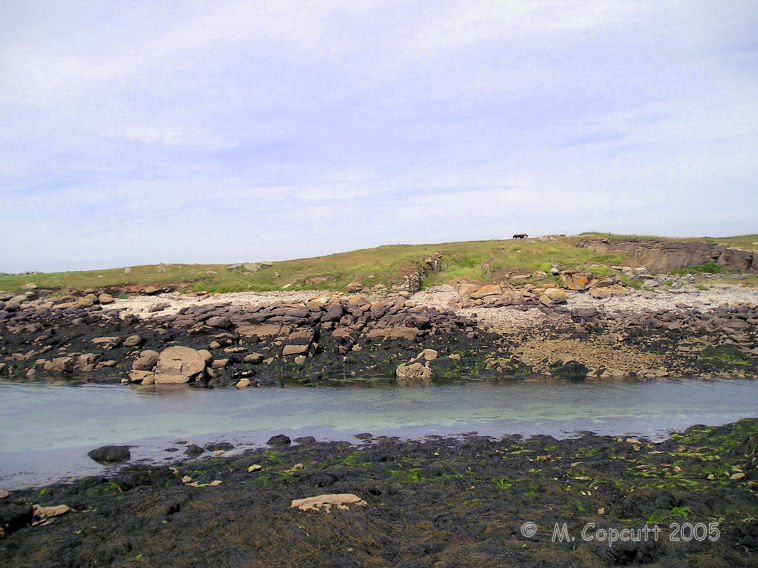
Île Melon menhirs submitted by thecaptain on 25th Jul 2009. View of Ile Melon from the end of the little harbour wall on the mainland.
The remains of two menhirs can be seen to the left of the picture, while the remaining dolmen is at the top of the island.
(View photo, vote or add a comment)
Log Text: This is frustrating. There is only 15 metres of water between me and the island from where I sit, but the tide is coming in and the island is not going to get any nearer. There is a dolmen on top of the island, and there are also at least two menhirs further down to the south of the island, and looking towards the shore. I believe that there was once a large menhir here also, which was blown up during the war. Perhaps a swim is needed !
Île Tariec cairn
Trip No.203 Entry No.518 Date Added: 28th May 2020
Site Type: Cairn
Country: France (Bretagne:Finistère (29))
Visited: Yes on 21st Jun 2005. My rating: Condition 2 Ambience 5 Access 2

Île Tariec cairn submitted by thecaptain on 20th Jun 2006. On the seaward part of the island are the remains of a chambered cairn and a small menhir.
(View photo, vote or add a comment)
Log Text: Just to the north of the menhir on this little island which can be reached at low tide, is the slight mound of a cairn. Its about 15 metres in diameter and 2 metres in height. I could see nothing in the way of structure under all the grass and stuff.
Île Tariec menhir
Trip No.203 Entry No.517 Date Added: 28th May 2020
Site Type: Standing Stone (Menhir)
Country: France (Bretagne:Finistère (29))
Visited: Yes on 21st Jun 2005. My rating: Condition 2 Ambience 5 Access 2

Île Tariec menhir submitted by thecaptain on 20th Jun 2006. On the seaward part of the island are the remains of a chambered cairn and a small menhir. The menhir is only about a metre high, a rock tapered towards the top, but in its position near the top of the island it can be clearly seen from all around.
This is the view to the west, with the reknowned island of Ile Guénioc and its cairns seen in the background.
(View photo, vote or add a comment)
Log Text: Just offshore from Presqu'ile Ste-Marguerite near the town of Landéda are a few small islands which can be reached at low tide, upon which there are stone monuments.
Ile Tariec is one of these, which can only be walked to for a short while each side of low tide, and the island became split into two parts in about 1876. The part of the island nearest to the mainland has the remains of a twelfth century hermitage on it, and the island was used to house dead and ill people in the past when suffering from plague, cholera etc.
On the outward part of the island are the remains of a dolmen and a small menhir. The menhir is only about a metre high, a rock tapered towards the top, but in its position near the top of the island it can be clearly seen from all around.
I was told by the camp site man that the midsummer solstice sun rise, when seen from here with your chin resting on the top of the menhir, supposedly rises between the legs of a dolmen on the main headland, but which has now unfortunately fallen in the dunes. Its a pity I wasn't here 4 or 5 hours ago, as I could have checked the theory. However, from a quick bit of reckoning and I don't think so, the mainland doesn't seem to stretch far enough to the north, but who am I to question the story? The northernmost tip of the mainland is at a bearing of about 075° from here.
Île-Coalen allée couverte
Trip No.203 Entry No.577 Date Added: 5th Jun 2020
Site Type: Passage Grave
Country: France (Bretagne:Côtes-D'Armor (22))
Visited: Yes on 25th Jun 2005. My rating: Condition 2 Ambience 4 Access 3

Île-Coalen allée couverte submitted by thecaptain on 30th Mar 2006. The remains of this allée couverte can be found at low tide on the beach at the southwestern corner of Ile Coalen, at the northwest entry to the Trieux river estuary.
There is possibly the remains of a peristalith around it, or perhaps its bits of broken capstone, I cannot tell.
(View photo, vote or add a comment)
Log Text: The remains of this monument can be found at low tide on the beach at the southwestern corner of Ile Coalen, which is just offshore from the mainland at the northwest entry to the Trieux river estuary. The island can be reached by walking from the mainland when the tide is out.
It is the remains of an allée couverte, the chamber of which has an orientation of 155°, the length of which was indeterminate to me. At the northwestern end is the remains of a seperate cell a couple of metres in length. Several side slabs, plus the two cross slabs are still in position, but the rest of it is a bit of a jumble, and has been knocked about a bit over the years. There is possibly the remains of a peristalith around it, or perhaps its bits of broken capstone, I cannot tell.
I enjoy coming to these island places - much more fun to come to than a field wall or suchlike.
Ilkerton Ridge Barrows
Date Added: 18th Sep 2010
Site Type: Barrow Cemetery
Country: England (Devon)
Visited: Yes on 11th May 2010
Ilkerton Ridge Barrows submitted by TheCaptain on 11th May 2010. Several barrows and cairns are to be found on the crest of Ilkerton Ridge, one or two quite large and in very good condition, some of them very small and deteriorated.
(View photo, vote or add a comment)
Log Text: None
Ilkerton Ridge stones
Date Added: 18th Sep 2010
Site Type: Standing Stones
Country: England (Devon)
Visited: Yes on 11th May 2010
Ilkerton Ridge stones submitted by TheCaptain on 11th May 2010. I found a single stone standing about three feet tall, in a hollow amongst the dense heather.
(View photo, vote or add a comment)
Log Text: None
Ilot Roc'h-Avel
Trip No.203 Entry No.515 Date Added: 28th May 2020
Site Type: Chambered Cairn
Country: France (Bretagne:Finistère (29))
Visited: Yes on 21st Jun 2005. My rating: Condition 2 Ambience 4 Access 3

Ilot Roc'h-Avel submitted by thecaptain on 18th Jun 2006. Ilot Roc'h-Avel is a small island just offshore from Presqu'ile Ste-Marguerite, which can be easily walked to from the beach at Kerennoc when not high tide.
Just inland and up a bit from the cairn cut in half by the sea is another cairn, again of which certain edge set stones suggest remains of a chamber.
(View photo, vote or add a comment)
Log Text: Just offshore from Presqu'ile Ste-Marguerite near the town of Landéda are a few small islands which can be reached at low tide, upon which there are stone monuments. Ilot Roc'h-Avel is one of these, which can be easily walked to from the beach at Kerennoc when not high tide tide.
Towards the western tip of the islet is the fascinating remains of a cairn which is now half on the island with the other half now taken by the sea. At the seaward edge can be seen a drystone walled chamber - only the northern half of which remains. A few large stones lie dotted about on the shoreline, which with a bit of imagination can be placed into position for some sort of chamber.
Just inland and up a bit from the cairn cut in half by the sea is another cairn, again of which certain edge set stones suggest remains of a chamber.
There are lots of children out on the beach below, obviously a school visit. All sorts of fun and games are going on, girls shreiking when their feet touch weed or shells! Brilliant. AAaaaaaaarggghhhh - its a crab !!!!!!
