Contributory members are able to log private notes and comments about each site
Sites TheCaptain has logged. View this log as a table or view the most recent logs from everyone
La Tardivière
Trip No.202 Entry No.35 Date Added: 26th Mar 2020
Site Type: Passage Grave
Country: France (Pays de la Loire:Mayenne (53))
Visited: Yes on 29th Apr 2005. My rating: Condition 3 Ambience 3 Access 4
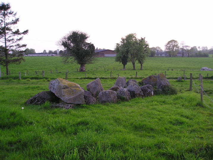
La Tardivière submitted by TheCaptain on 9th May 2005. La Tardivière allée couverte, Ernée, Mayenne.
Another little Mayenne allée couvert about 6 or 7 metres in length facing uphill and eastwards in lovely countryside.
(View photo, vote or add a comment)
Log Text: Another little Mayenne allée couverte about 6 or 7 metres in length facing uphill and eastwards. It is in fairly ruinous condition with only one capstone remaining at the top end of about 8 pairs of upright stones. There is a large end stone at the lower western end.
It is found in open rolling countryside marked on my ign map but not signposted. At the time of my visit it was in an open field about a hundred metres down the farm track from the country lane where I parked. About 30 metres down from the dolmen was a fairly large stone at the side of the farmtrack. Possibly a marker stone for the tomb but I suspect more likely one of the stones from the allée couverte moved away and dumped at some point.
La Table Submergée
Trip No.203 Entry No.292 Date Added: 26th Apr 2020
Site Type: Burial Chamber or Dolmen
Country: France (Pays de la Loire:Vendée (85))
Visited: Saw from a distance on 8th Jun 2005

La Table Submergée submitted by thecaptain on 11th Dec 2005. Out in the sea and mudflats of the Baie de Bourgneuf, a kilometre or two off from the northeastern coast of Ile Noirmoutier, is a dolmen which can be seen at low tide, but which gets covered by the high tide.
I reckon I could see it through my binoculars from the island, there's a very table like rock out there, and nothing else like it to be seen nearby.
(View photo, vote or add a comment)
Log Text: Out in the sea and mudflats, a kilometre or two off from the northeastern coast of Ile Noirmoutier, is a dolmen which can be seen at low tide. I reckon I can see it through my binoculars, there's a very table like rock out there, and nothing else to be seen. There is a boat moored nearby, probably fishing.
La Table du Sacrifice
Trip No.203 Entry No.406 Date Added: 14th May 2020
Site Type: Burial Chamber or Dolmen
Country: France (Bretagne:Morbihan (56))
Visited: Yes on 13th Jun 2005. My rating: Condition 4 Ambience 4 Access 4
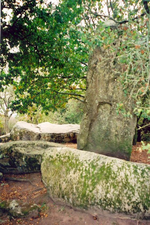
La Table du Sacrifice submitted by LizH on 6th Nov 2007. In this picture, the furthest north stone (lying) can be seen. Behind it, however, at the back of the picture, this stone looks more as if it could be a 'table' and even possibly a 'sacrifice table' in the minds of those who named it. I am not sure which one is the official 'Table du sacrifice'.
(View photo, vote or add a comment)
Log Text: Pretty much in the middle of the Géants de Kerzerho are two fallen giants, more than six metres long. It looks like one of the flat fallen stones may have been used as a dolmen with a chamber underneath it.
Perhaps they are not fallen giants. Maybe this is the true Pierre des Sacrifices. Maybe it was a fallen giant then used in later times for other purposes.
Whatever this all is here, its a wonderful place.
La Table des Marchands
Trip No.203 Entry No.351 Date Added: 10th May 2020
Site Type: Burial Chamber or Dolmen
Country: France (Bretagne:Morbihan (56))
Visited: Yes on 11th Jun 2005. My rating: Condition 5 Ambience 3 Access 3

La Table des Marchands submitted by JJ on 9th Nov 2002. La Table des Marchands
(View photo, vote or add a comment)
Log Text: Much has been written about this place by others already, and I wont spend valuable daylight by sitting and writing anymore for myself, except to say that it is all very different to what it was in 1987, and that the current thinking is that the Grand Menhir was once just one of 19 stood up in a row, and was toppled deliberately after only a couple of hundred years. The other menhirs were broken and used for other purposes.
La Table des Fées, Chêneduit
Trip No.202 Entry No.57 Date Added: 28th Mar 2020
Site Type: Burial Chamber or Dolmen
Country: France (Normandie:Orne (61))
Visited: Yes on 1st May 2005. My rating: Condition 2 Ambience 3 Access 3
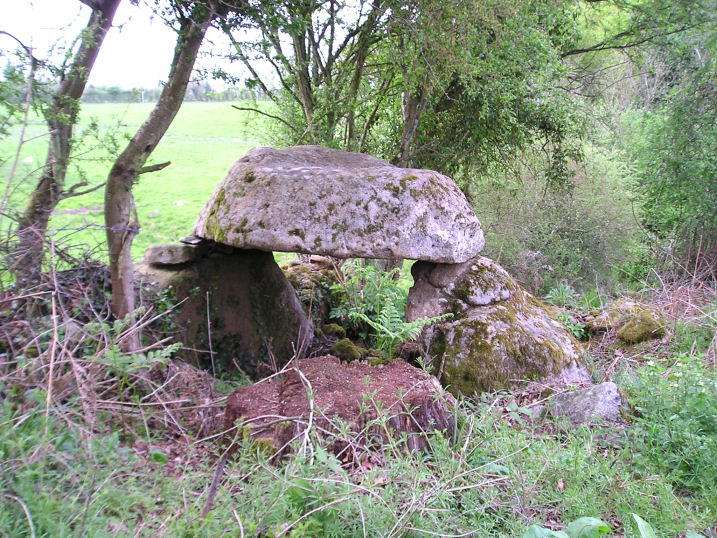
La Table des Fées, Chêneduit submitted by TheCaptain on 11th May 2005. La Table des Fées, Chêneduit, Orne.
a small dolmen which has been built into a field wall. The remains consist of a capstone which is sitting on top of a pair of uprights, in a somewhat unlikely position on a steep slope above a small stream
(View photo, vote or add a comment)
Log Text: Although marked on my ign map there are no signs to this in an area of small fields and many rocky outcrops. I asked a lady in a house with a small imitation dolmen in the garden and she seemed pleased that somebody was looking for it. I was informed that it was called the Table-des-Fées and she pointed me to it over a couple of fields.
It is a small dolmen which has been built into a field wall. The remains consist of a capstone which is sitting on top of a pair of uprights in a somewhat unlikely position on a steep slope above a small stream. The capstone is about 2 metres and rounded more than a metre off the ground. There are many other large stones here and I suspect that there was once a lot more to it.
La Table des Diables
Trip No.202 Entry No.47 Date Added: 28th Mar 2020
Site Type: Burial Chamber or Dolmen
Country: France (Pays de la Loire:Mayenne (53))
Visited: Yes on 30th Apr 2005. My rating: Condition 2 Ambience 4 Access 3

La Table des Diables submitted by TheCaptain on 10th May 2005. La Table des Diables, Sainte Suzanne, Mayenne.
A lot of this site looks natural until you look closely.
(View photo, vote or add a comment)
Log Text: Also known as La Pierre au Diable this site is an 800 metre signposted uphill walk southwards from a parking place near to la Vallette. As with many of these monuments this is at the top of a ridge within an enchanting forest full of birdsong and wildflowers – a cuckoo being particularly prominent here. The stones are surrounded by wizened old oak trees and large pines without which the views would be superb.
A lot of this site looks natural until you look closely. Apart from the very large (4 m by 2 m) stone sat on top of a rocky outcrop with a couple of small supports just west of this are remains of what looks to me like a wrecked allée couverte with two rows of parallel edge set stones about a metre apart. Perhaps the large rock on top of the outcrop was once a capstone for this ruined monument.
La Table aux Diables (Passais)
Trip No.202 Entry No.19 Date Added: 26th Mar 2020
Site Type: Passage Grave
Country: France (Normandie:Orne (61))
Visited: Yes on 24th Apr 2005. My rating: Condition 4 Ambience 4 Access 5
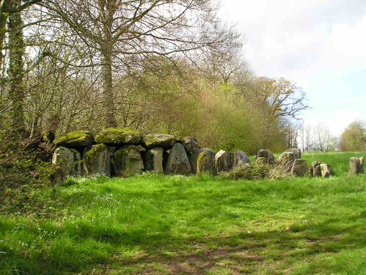
La Table aux Diables (Passais) submitted by TheCaptain on 7th May 2005. La Table aux Diables allée couverte, Passais, Orne.
A surprise find, this smashing little lateral entry Allée Couvert is about 12 or 13 metres in length, seen here from the southeast.
(View photo, vote or add a comment)
Log Text: Blimey what a pleasure to find this monument signposted from the Mantilly to Passais road as well as marked on the ign map. Heading south along the small road just west of Passais and turn right just before a little fishing lake is reached. A few hundred yards up a small track and the monument is found in a field to the right.
A surprise find this is a smashing little lateral entry Allée Couvert is about 12 or 13 metres in length with an orientation of 049° Magnetic. The main chamber is about 1.5 metres in width with 4 large capstones still remaining on 6 pairs of uprights at the western end with a height of 2 metres at the end dropping to 1.5 metres at the open end. The eastern end is more ruinous and the entrance is near the eastern end on the south side. The internal faces of the chamber stones have been nicely smoothed and are very well aligned with each other the gaps being filled with drystone walling. The outer walling of the peristalith is almost complete around the northern side and there are many stones remaining of the cairn filling between the inner and outer walls in the northwest quadrant. Only about half of the outer wall of stones remain on the southern side.
La Table au Loup
Trip No.205 Entry No.255 Date Added: 13th Dec 2020
Site Type: Burial Chamber or Dolmen
Country: France (Auvergne:Cantal (15))
Visited: Yes on 26th Sep 2005. My rating: Ambience 3 Access 4
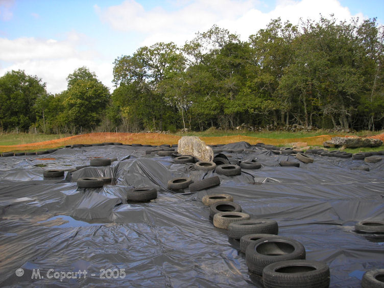
La Table au Loup submitted by thecaptain on 4th Nov 2008. The dolmen was undergoing excavation when I visited in 2005, and apart from a large side slab sticking up out of the middle, and obvious remains of a mound, there was nothing much I could see here.
(View photo, vote or add a comment)
Log Text: West of the village of Sériers, along the new D.990 road towards Pierrefort, about 500 metres from the junction with the D.921 is a sign for the dolmen. It is then about an 800 metre walk along a signposted gravel trackway across marshy land before you reach the dolmen, or as I found, a fenced off plastic sheeting covered area! The dolmen was undergoing excavation, and apart from a large side slab sticking up out of the middle, and obvious remains of a mound, there was nothing I could see here.
La Sulette Dolmen
Trip No.203 Entry No.273 Date Added: 24th Apr 2020
Site Type: Burial Chamber or Dolmen
Country: France (Pays de la Loire:Vendée (85))
Visited: Yes on 6th Jun 2005. My rating: Condition 5 Ambience 4 Access 5
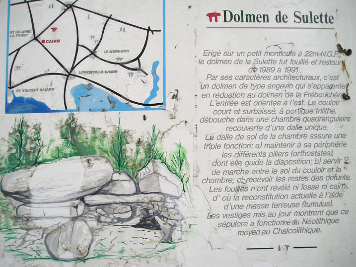
La Sulette dolmen submitted by thecaptain on 13th Dec 2005. La Sulette dolmen, St Hilaire-la-Foret, Vendée
(View photo, vote or add a comment)
Log Text: This is a pleasant find, as it has been fully excavated and restored in 1989 to 1991, and is now found completely within its mound. It is a small Angevin dolmen, with a 2 metre by 2 metre chamber made using 4 side stones with drystone walling between them. It has a single capstone, and again, it has a smoothed slab on the floor. The chamber opens to the outside at the east, where there is a small entrance portal.
La Roque-Saint-Christophe
Trip No.203 Entry No.74 Date Added: 5th Apr 2020
Site Type: Ancient Village or Settlement
Country: France (Aquitaine:Dordogne (24))
Visited: Yes on 18th May 2005. My rating: Condition 4 Ambience 5 Access 4
La Roque-Saint-Christophe submitted by theCaptain on 6th Jan 2011. In the gigantic cliff face on the opposite side of the river Vézère to the delightful village of Le Moustoir is found this World Heritage Site. It's an entire troglodytic city which was inhabited continuously from 50000 years ago until a few centuries ago.
(View photo, vote or add a comment)
Log Text: In the gigantic cliff face on the opposite side of the river Vézère to the delightful village of Le Moustoir is found this World Heritage Site. It's an entire troglodytic city which was inhabited continuously from 50000 years ago until a few centuries ago. It's massive. Even knowing it is five levels high and having visited it 27 years ago doesn’t stop it being mind blowing. It's really awe inspiring.
I guess most of what is seen today dates back to the middle ages with all the rock hewn staircases and houses but even so the basic layout of the cliff face city hasn’t changed in millennia. It even has its own little harbour in the river.
La Roque-Saint-Christophe
Date Added: 21st Oct 2020
Site Type: Ancient Village or Settlement
Country: France (Aquitaine:Dordogne (24))
Visited: Yes on 19th Sep 1978
La Roque-Saint-Christophe submitted by theCaptain on 6th Jan 2011. In a gigantic cliff face beside the river Vézère is found this World Heritage Site.
It's an entire troglodytic city which was inhabited continuously from 50000 years ago until a few centuries ago.
(View photo, vote or add a comment)
Log Text: Hitch Hiking Trip round France in the summer of 1978. Camped for a couple of days at Les Eyzies to visit and wonder at the ancient sites here.
La Roche Vernaise
Trip No.204 Entry No.106 Date Added: 3rd Aug 2020
Site Type: Burial Chamber or Dolmen
Country: France (Poitou:Vienne (86))
Visited: Couldn't find on 17th May 2005. My rating: Condition 1 Ambience 2 Access 4

La Roche Vernaise submitted by Rubis on 22nd Sep 2010. In fact, at first view, it seems to have two dolmens.
(View photo, vote or add a comment)
Log Text: On top of a hillock near a junction of lanes to the west of La Roche Vernaise is a big jumble of large stones. It is hard to know whether this is the actual dolmen, or just a load of field clearance stones, but it was the only likely candidate I found in this area. Perhaps it has all been fairly recently all moved to the edges of the fields. There is a lot of stone, so perhaps it was a fairly big dolmen, at least 10 metres in length. It is difficult to know. I don't think I actually found the real dolmen, which is perhaps a bit to the north of here.
La Roche Piquée (Baudouinais)
Trip No.204 Entry No.325 Date Added: 16th Sep 2020
Site Type: Standing Stone (Menhir)
Country: France (Bretagne:Ille-et-Vilaine (35))
Visited: Yes on 13th Aug 2005. My rating: Condition 3 Ambience 3 Access 3
La Roche Piquée (Baudouinais) submitted by thecaptain on 24th Feb 2007. When I visited, the field was well fenced off, and full of cows, so I didn't get to visit the stone properly, but I would estimate it to be about 4 metres tall.
(View photo, vote or add a comment)
Log Text: A few kilometres to the west of the village of Livré-sur-Changeon, and a few kilometres to the south of the little town of St-Aubin-du-Cormier, near to the hamlet of Baudouinais can be seen this menhir marked on some of my maps as Pierre Piquée. It is signposted, and after a little walk along a farm track it can be seen across the fields. When I visited, the field was well fenced off, and full of cows, so I didn't get to visit the stone properly, but I would estimate it to be about 4 metres tall.
La Roche Longue (St-Marcan)
Trip No.203 Entry No.603 Date Added: 13th Jun 2020
Site Type: Standing Stone (Menhir)
Country: France (Bretagne:Ille-et-Vilaine (35))
Visited: Yes on 28th Jun 2005. My rating: Condition 3 Ambience 3 Access 3
La Roche Longue (St-Marcan) submitted by thecaptain on 6th Mar 2007. Probably 3 to 4 metres tall, in a field near the cemetary to the east of the village of St Marcan, on a slope overlooking the marshes of the bay of Mont St Michel.
(View photo, vote or add a comment)
Log Text: A large slab sided menhir, about 3 metres tall with its wide sides oriented east and west, in a field near to the cemetary to the east of the village of St Marcan, on a slope overlooking the marshes of the bay of Mont St Michel. Whilst I couldn’t get right to it, the menhir is easily visible from the roadside. About 800 metres to the south of this menhir used to stand another similar menhir 2 metres tall, which was destroyed in the 1930s
La Roche Longue (St-Marcan)
Trip No.209 Entry No.13 Date Added: 13th Jun 2020
Site Type: Standing Stone (Menhir)
Country: France (Bretagne:Ille-et-Vilaine (35))
Visited: Yes on 12th Jun 2009. My rating: Condition 4 Ambience 3 Access 4

La Roche Longue (St-Marcan) submitted by thecaptain on 30th Jun 2009. View of La Roche Longue seen from the west.
(View photo, vote or add a comment)
Log Text: This well shaped menhir is just under 3 metres tall in a field to the east of the St Marcan cemetary. As with my previous visit, the field is planted with maize, and is today sodden wet, which prevents me from being abole to walk right up to the stone. However, this time I can walk up the western edge of the field by the cemetary, and photograph its other side in the afternoon sunshine.
La Roche Blanche
Trip No.204 Entry No.4 Date Added: 22nd Jun 2020
Site Type: Round Cairn
Country: France (Bretagne:Morbihan (56))
Visited: Yes on 9th Jul 2005. My rating: Condition 3 Ambience 3 Access 3

La Roche Blanche submitted by TheCaptain on 2nd Jun 2007. This is a nice shining white quartz block within a circle of local schist stones.
It is thought to probably mark the grave of an individual, rather than being a collective grave.
(View photo, vote or add a comment)
Log Text: This is a nice shining white quartz block within a sort of circle of local schist stones. It is thought to probably mark the grave of an individual, rather than being a collective grave. It can be found about a kilometres walk from the Monteneuf visitors centre, through the forests along a marked trail.
La Roche au Diable (Paley)
Trip No.204 Entry No.246 Date Added: 6th Sep 2020
Site Type: Polissoir
Country: France (Ile-de-France:Seine-et-Marne 77)
Visited: Couldn't find on 6th Aug 2005
Log Text: Marked near to the menhir is a polissoir stone, in the woods down by the little river. I could find no obvious signpost or footpath towards where it is marked, and having now found out how difficult to find some of these polissoir stones are to find, I didnt spend any time looking.
La Roche (Uzel)
Trip No.203 Entry No.587 Date Added: 8th Jun 2020
Site Type: Standing Stone (Menhir)
Country: France (Bretagne:Côtes-D'Armor (22))
Visited: Yes on 26th Jun 2005. My rating: Condition 3 Ambience 3 Access 5
La Roche (Uzel) submitted by theCaptain on 4th Jul 2012. This little menhir is probably about 2.5 metres tall, standing on the slopes above the road and stream, positioned just outside a wood, making it visible from the road.
(View photo, vote or add a comment)
Log Text: This little menhir is probably about 2.5 metres tall, standing on the slopes above the road and stream, positioned just outside a wood, making it visible from the road. I thought this to be a strange place for a menhir, on a slope this steep.
La Quenouille de Gargantua
Trip No.204 Entry No.29 Date Added: 6th Jul 2020
Site Type: Standing Stone (Menhir)
Country: France (Bretagne:Morbihan (56))
Visited: Couldn't find on 11th Jul 2005
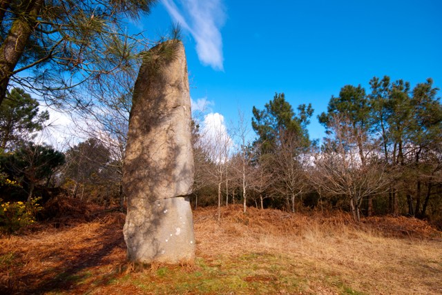
La Quenouille de Gargantua submitted by ogham on 19th Mar 2013. Still standing after all the others were pulled down.
(View photo, vote or add a comment)
Log Text: I could not find this.
La Pointue Rocque
Date Added: 29th Oct 2019
Site Type: Standing Stone (Menhir)
Country: Channel Islands and Isle of Man (Guernsey)
Visited: Yes on 10th Feb 2019

La Pointue Rocque submitted by TheCaptain on 10th Feb 2019. From Saxon101
photograph taken of the remains of this site, which was incorporated into a boundary wall, probably in the 18th century.
(View photo, vote or add a comment)
Log Text: None
