Contributory members are able to log private notes and comments about each site
Sites TheCaptain has logged. View this log as a table or view the most recent logs from everyone
Ménec alignements
Trip No.203 Entry No.383 Date Added: 11th May 2020
Site Type: Multiple Stone Rows / Avenue
Country: France (Bretagne:Morbihan (56))
Visited: Yes on 12th Jun 2005. My rating: Condition 5 Ambience 5 Access 5

Ménec alignements submitted by thecaptain on 18th Oct 2004. Ménec alignements, north of Carnac, Brittany, France.
View of the Menec Alignements as they were in summer 1987, when you could walk amongst them.
I must go back for another visit sometime
(View photo, vote or add a comment)
Log Text: Fantastic in the evening light, and I have them almost all to myself.
Ménec cromlech
Trip No.203 Entry No.382 Date Added: 11th May 2020
Site Type: Stone Circle
Country: France (Bretagne:Morbihan (56))
Visited: Yes on 12th Jun 2005. My rating: Condition 4 Ambience 4 Access 5

Ménec cromlech submitted by AlexHunger on 20th Dec 2004. The Cromlec de Menec marks the westernmost extent of the Carnac Allignments. It basically starts on the road that separates it from the allignments, goes through a private garden, through the end of the village and ends in a creperie.
(View photo, vote or add a comment)
Log Text: Curving around the Creperie at the western end of the Menec alignements, this almost contiguous semicircle of stones really is splendid, and most people who visit the nearby stones do not know that it is there, or think that it’s a wall. All sorts of other bits of the cromlech can be found in between the buildings of the Menec hamlet. This place really is magic without the people.
Kerlescan nord allée couverte
Trip No.203 Entry No.381 Date Added: 11th May 2020
Site Type: Passage Grave
Country: France (Bretagne:Morbihan (56))
Visited: Yes on 12th Jun 2005. My rating: Condition 3 Ambience 4 Access 4

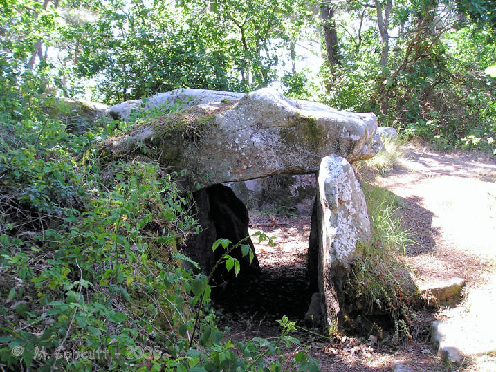
Kerlescan nord allée couverte submitted by Martin_L on 22nd Jan 2009. Inside the chamber.
(May 2001)
(View photo, vote or add a comment)
Log Text: The remains of this monument can be found at the eastern end of the Kerlescan alignements, around the back to the north, and in a wood. It is about 60 metres long by 8 metres wide tumulus, completely surrounded by a stone peristalith. Inside this mound is a 16 metre long lateral entrance allee couverte type structure, but unfortunately with only one remaining capstone at the western end. Its entry is from the southern side near the east end. The mound is rectangular in shape at the western end, and curved at the east, and is still 2 or 3 metres high.
Kerlescan cromlech
Trip No.203 Entry No.379 Date Added: 11th May 2020
Site Type: Stone Circle
Country: France (Bretagne:Morbihan (56))
Visited: Yes on 12th Jun 2005. My rating: Condition 4 Ambience 4 Access 5

Kerlescan cromlech submitted by LizH on 31st Oct 2007. The eastern stones of the western Kerlescan cromlech. The stones touch each other and face across (N-S) rather than being aligned E-W as the rows are.
(View photo, vote or add a comment)
Log Text: None
Kerlescan Alignements
Trip No.203 Entry No.380 Date Added: 11th May 2020
Site Type: Multiple Stone Rows / Avenue
Country: France (Bretagne:Morbihan (56))
Visited: Yes on 12th Jun 2005. My rating: Condition 5 Ambience 5 Access 5

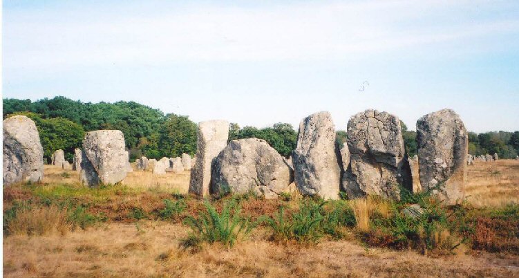
Kerlescan Alignements submitted by thecaptain on 18th Oct 2004. Kerlescan Alignements, northeast of Carnac, Brittany.
This picture was taken looking west in 1987, when wandering amongst the stones was OK. I think many of them have been fenced off to try and combat erosion these days. I must go back sometime.
(View photo, vote or add a comment)
Log Text: I am not going to say much about the major Carnac alignements, except to say that they are all absolutely mind blowing. Even though I saw them all those years ago, the first sight of all those stones lined up is incredible, especially in the strong evening sunshine.
I cannot possibly do justice to these stones with my writing or photographs. I will say that the fences surrounding the stones are not obtrusive, unlike the fences at stonehenge, and with the vegetation returning, they all look FAR, FAR better than they did in 1987 with all the soil erosion around them all. I must come back and do the full tour at some time.
Kermario Alignements
Trip No.203 Entry No.378 Date Added: 11th May 2020
Site Type: Multiple Stone Rows / Avenue
Country: France (Bretagne:Morbihan (56))
Visited: Yes on 12th Jun 2005. My rating: Condition 5 Ambience 4 Access 5

Kermario Alignements submitted by thecaptain on 18th Oct 2004. Kermario Alignements, north of Carnac, Brittany.
View of some of the enormous stones which go to make up part of the Kermario Alignements. This picture was taken in 1987 when people were free to wander amongst the stones as they pleased. The terrible erosion caused by all the visitors is only to obvious.
(View photo, vote or add a comment)
Log Text: I am not going to say much about the major Carnac alignements, except to say that they are all absolutely mind blowing. Even though I saw them all those years ago, the first sight of all those stones lined up is incredible, especially in the strong evening sunshine.
I cannot possibly do justice to these stones with my writing or photographs. I will say that the fences surrounding the stones are not obtrusive, unlike the fences at stonehenge, and with the vegetation returning, they all look FAR, FAR better than they did in 1987 with all the soil erosion around them all. I must come back and do the full tour at some time.
Kermario Dolmen
Trip No.203 Entry No.377 Date Added: 11th May 2020
Site Type: Burial Chamber or Dolmen
Country: France (Bretagne:Morbihan (56))
Visited: Yes on 12th Jun 2005. My rating: Condition 4 Ambience 3 Access 5

Kermario Dolmen submitted by thecaptain on 18th Oct 2004. Kermario Dolmen, north of Carnac, Brittany.
View of the Kermario Dolmen which is right at the southwest corner of the Kermario Alignements, and right in the corner of the road which skirts the site.
This picture was taken in 1987 when people were free to wander amongst the stones as they pleased. The terrible erosion caused by all the visitors is only too obvious.
(View photo, vote or add a comment)
Log Text: None
Menhir du Moustoir
Trip No.203 Entry No.376 Date Added: 11th May 2020
Site Type: Standing Stone (Menhir)
Country: France (Bretagne:Morbihan (56))
Visited: Yes on 12th Jun 2005. My rating: Condition 4 Ambience 3 Access 4

Menhir du Moustoir submitted by thecaptain on 10th Jun 2006. The Moustoir tumulus has a small menhir on the top at the eastern end, and a larger one at the bottom of the western end.
The menhir at the western end is 3.3 metres high, quite thin and a nice pointed triangular shape.
(View photo, vote or add a comment)
Log Text: Just beside the western end of the massive Moustoir tumulus is a nice menhir, 3.3 metres high, quite thin and a nice pointed triangular shape.
Moustoir tumulus
Trip No.203 Entry No.375 Date Added: 11th May 2020
Site Type: Chambered Tomb
Country: France (Bretagne:Morbihan (56))
Visited: Yes on 12th Jun 2005. My rating: Condition 4 Ambience 4 Access 5

Moustoir tumulus submitted by thecaptain on 10th Jun 2006. This massive great mound, 90 metres in length, 40 metres wide and 8 metres high, can be found just to the south of the hamlet of Moustoir, a few kilometres to the north of Carnac.
It has become terribly overgrown.
(View photo, vote or add a comment)
Log Text: This massive great mound, 90 metres in length, 40 metres wide and 8 metres high, can be found just to the south of the hamlet of Moustoir, a few kilometres to the north of Carnac. The mound is aligned roughly Northeast to Southwest, and has a small menhir on the top at the eastern end, and a larger one at the bottom of the western end.
The menhir on the top of the tumulus is about 2.1 metres high and quite slender, and of a sort of circular section. The menhir at the western end is 3.3 metres high, quite thin and a nice pointed triangular shape.
Towards the western end of the mound is an entrance in the southern side, which after a short passage opens up into a 5 metre by 2.5 metre chamber, with a large capstone and some reinforced concrete. The walls are a mix of large slabs and drystone walling. You need a good torch to see your way around.
There is more to this tumulus, as on the top of the mound near the eastern menhir can be seen a reinforced steel cover to something, indicating that there may be another chamber inside, for which I could find no entry. As for the majority of the monuments around here, this is all terribly overgrown, and difficult to properly make out what is here.
Mané-Brizil Dolmen
Trip No.203 Entry No.374 Date Added: 11th May 2020
Site Type: Burial Chamber or Dolmen
Country: France (Bretagne:Morbihan (56))
Visited: Saw from a distance on 12th Jun 2005

Mané-Brizil dolmen submitted by binardino on 14th Jun 2006. Mané-Brizil dolmen
(View photo, vote or add a comment)
Log Text: This dolmen is now within private property, but a few stones of what is possibly the dolmen with couloir can be seen inside the entrance of a large chateau like place, up the driveway entrance.
Crucuny Cromlech
Trip No.203 Entry No.373 Date Added: 11th May 2020
Site Type: Stone Circle
Country: France (Bretagne:Morbihan (56))
Visited: Yes on 12th Jun 2005. My rating: Condition 3 Ambience 3 Access 5
Crucuny Cromlech submitted by TheCaptain on 9th Nov 2010. To the south of the hamlet of Crucuny, this ancient cromlech is now incorporated into a semicircular wall.
There are several big stones to be seen, with smaller ones in between them, which in places are almost contiguous.
(View photo, vote or add a comment)
Log Text: To the south of the hamlet of Crucuny, and marked on my map as a menhir, this ancient cromlech is now incorporated into a semicircular wall. There are several big stones to be seen, with smaller ones in between them, which in places are almost contiguous.
Menhir de Crucuny 1
Trip No.203 Entry No.372 Date Added: 11th May 2020
Site Type: Standing Stone (Menhir)
Country: France (Bretagne:Morbihan (56))
Visited: Couldn't find on 12th Jun 2005

Menhir de Crucuny 1 submitted by stollentroll on 14th Dec 2005. Menhir on top of the tumulus Crucuny.
(View photo, vote or add a comment)
Log Text: On top of the tumulus, to the north of the hamlet, is a menhir, 2.8 metres tall, with axes carved on it. But it is all very overgrown and covered in gorse, and I could not get to see anything at close quarters.
Crucuny tumulus
Trip No.203 Entry No.371 Date Added: 11th May 2020
Site Type: Long Barrow
Country: France (Bretagne:Morbihan (56))
Visited: Yes on 12th Jun 2005. My rating: Condition 3 Ambience 3 Access 5

Crucuny tumulus submitted by thecaptain on 10th Jun 2006. This is a large mound, over 50 metres long, 25 metres wide and 13 metres high, to be seen just to the north of the Crucuny hamlet, but all very overgrown and covered in gorse.
The road partially goes over the mound.
(View photo, vote or add a comment)
Log Text: There is a large mound, 50 metres long and 13 metres high, to be seen just to the north of the hamlet, but all very overgrown and covered in gorse. On top of the tumulus is a menhir, 2.8 metres tall, with axes carved on it.
Dolmen de La Madeleine (Carnac)
Trip No.203 Entry No.370 Date Added: 11th May 2020
Site Type: Burial Chamber or Dolmen
Country: France (Bretagne:Morbihan (56))
Visited: Yes on 12th Jun 2005. My rating: Condition 3 Ambience 3 Access 3

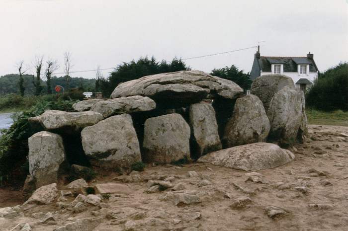
Dolmen de La Madeleine (Carnac) submitted by minteddy on 10th Sep 2008. Site in Bretagne, Morbihan D56: Grid ref 03 02’ 54’’ West 47 37’ 16’’ As can be seen, this dolmen is in a ruinous state. The capstone has slipped off its supports on one side.
(View photo, vote or add a comment)
Log Text: Blimey, this dolmen is not hidden in dense woodland ! It is to be found in an open field at the top of a little raise, but the field was closed off with an electric fence, so I didn’t go in to see the dolmen at close quarters.
Le Petit Ménec
Trip No.203 Entry No.369 Date Added: 11th May 2020
Site Type: Multiple Stone Rows / Avenue
Country: France (Bretagne:Morbihan (56))
Visited: Yes on 12th Jun 2005. My rating: Condition 4 Ambience 5 Access 4

Le Petit Ménec submitted by ermine on 6th Aug 2004. Confusingly, Petit-Menéc is in fact at the opposite, eastern end of the alignments to le Menéc village at the western end. You need to turn left onto the D186 main road after continuing from Kerlescan. After about 250m turn right into a minor road going past a forest, there is a clearing where you can park after about 400m. The menhirs are in the forest on your right, arranged in a gentle curve. You don't get the same clear overview of the alignments since the view is obscured by the trees, bu...
(View photo, vote or add a comment)
Log Text: This is a nice place to explore on a hot afternoon, a nice walk in a cool woodland filled with stones. There are hundreds of them to be seen, lined up through the woods, mostly less than a metre tall but some reach up to about 2 metres. There are round ones, pointy ones, square ones, thick ones, thin ones, indeed all shapes and sizes. Look a bit further into the woods away from the footpath and you'll find more stones.
The lines seem to get closer together, as does the spacing of the stones, the further east you go, but nothing seems very ordered or regular. From where I sit and have a contemplate, I can count 8 rows, but there are probably more hidden by trees or under walls.
Excellent. I later find out that there was once much more to be seen here, with the rows being destroyed and removed in order to build the Belle Ile lighthouse.
Kermarquer Dolmen
Trip No.203 Entry No.368 Date Added: 11th May 2020
Site Type: Burial Chamber or Dolmen
Country: France (Bretagne:Morbihan (56))
Visited: Yes on 12th Jun 2005. My rating: Condition 3 Ambience 3 Access 4

Kermarquer dolmen submitted by TheCaptain on 8th Nov 2007. This dolmen is much easier to find than its neighbour Mané Bras, but still involves 100 metres of fighting a way through gorse and bramble filled woodland.
(View photo, vote or add a comment)
Log Text: This one is much easier to find than its neighbour, but still involves 100 metres of fighting a way through gorse and bramble filled woodland. The monument is a strange one, with two chambers off of a single entry corridor. The main chamber, a rectangular 2.5 metres by 2.5 metres has no capstone, and leads straight off of the corridor. The second chamber is off to the side of this, with its entry at the side of chamber 1, and is about 1.5 m by 1.5 m, and is covered by a capstone. The corridor has two large capstones still in place. This monument is still mostly contained within its mound, and all very overgrown, making photographs very difficult.
Mané Bras
Trip No.203 Entry No.367 Date Added: 11th May 2020
Site Type: Burial Chamber or Dolmen
Country: France (Bretagne:Morbihan (56))
Visited: Yes on 12th Jun 2005. My rating: Condition 3 Ambience 3 Access 3

Mané Bras submitted by TheCaptain on 7th Nov 2007. According to a signpost at the roadside, it is only a 500 metre walk along a bridlepath to this monument.
However, in practice for me in June 2005 it involved crossing a swamp, negotiating woodland full of brambles and nettles, then crossing an open tract of heather, and last but by no means least, somehow getting through a gorse jungle.
(View photo, vote or add a comment)
Log Text: According to a signpost at the roadside, it is only a 500 metre walk along a bridlepath to this monument. However, in practice it involved crossing a swamp, negotiating woodland full of brambles and nettles, then crossing an open tract of heather, and last but by no means least, somehow getting through a gorse jungle.
Its a nice monument to find though, as two passagewayed dolmens look out of their mound at you upon finally reaching it. On the right, the northern chamber is about 3m by 3 metres rectangular with a 4 metres passageway to the east. On the left, a 4 m by 3 metre oval chamber, without capstone, has about a 6 metre passage leading out to the edge of the mound. It was all far too overgrown though, and getting photograps was nearly impossible.
Many of these lesser known sites need a good dose of TLC. I later found that there are more dolmens and cjambers to be found here in th hilltop mound. Obviously one for another visit it some time.
Dolmen de Mane Rohr
Trip No.203 Entry No.366 Date Added: 11th May 2020
Site Type: Burial Chamber or Dolmen
Country: France (Bretagne:Morbihan (56))
Visited: Couldn't find on 12th Jun 2005

Dolmen de Mane Rohr submitted by Martin_L on 31st Jan 2009. Dolmen de Mane Rohr at dusk in May 2001. It is an absolutely terrific site, but somewhat overgrown. In 2001 it was possible to cross a sports ground and then follow a narrow track through a little "jungle". It is not signposted, but if you are in this area you should buy the 1:25000 map anyway :-)
(View photo, vote or add a comment)
Log Text: Despite being clearly marked on the map, besides the sports ground and with a footpath to it, I could find no way through the houses to the hilltop position in the real world.
Mané Roullarde
Trip No.203 Entry No.365 Date Added: 11th May 2020
Site Type: Burial Chamber or Dolmen
Country: France (Bretagne:Morbihan (56))
Visited: Yes on 12th Jun 2005. My rating: Condition 2 Ambience 3 Access 4

Mané Roullarde submitted by TheCaptain on 10th Nov 2007. The informative multilingual signboard.
(View photo, vote or add a comment)
Log Text: The remains of this monument are to be found on a hilltop site overlooking the yachting and seaside town of La Trinité-sur-Mer, now surrounded by expensive looking flats. There is an 18 metre long Allée Couverte known as Er-Groh, with only 4 capstones remaining in place, which faces southeast at 150°. Some of the side support stones have Pierres-Plates style engravings on them, but being exposed in this external situation, they are very difficult to make out amongst the lichens and moss etc.
At some point in the past it has had a wall built into it. There are also said to be several underground passages to be found here, which date back to Gallic iron age times, and of which the description reminds me of the Cornish Fougous. However, I found it impossible to find any of these to be seen amongst the undergrowth of the area.
Kervehennec Dolmen
Trip No.203 Entry No.364 Date Added: 11th May 2020
Site Type: Burial Chamber or Dolmen
Country: France (Bretagne:Morbihan (56))
Visited: Yes on 12th Jun 2005. My rating: Condition 3 Ambience 3 Access 4
Kervehennec dolmen submitted by TheCaptain on 12th Jun 2011. In a little area behind Kervehennic farm can be seen the remains of this dolmen still largely in its tumulus on top of a little granite hillock.
(View photo, vote or add a comment)
Log Text: To the north of the D781 road, in a little area behind Kervanhennic farm can be seen the remains of this fairly wrecked dolmen on top of a little granite hillock. There is not much more than a single 3 m by 2 metres capstone and a few support stones to be seen. It looks to have had a wall built into it in the past, and it is becoming overgrown.
