Contributory members are able to log private notes and comments about each site
Sites TheCaptain has logged. View this log as a table or view the most recent logs from everyone
Kerivoret Dolmen
Trip No.203 Entry No.504 Date Added: 27th May 2020
Site Type: Burial Chamber or Dolmen
Country: France (Bretagne:Finistère (29))
Visited: Yes on 20th Jun 2005. My rating: Condition 4 Ambience 3 Access 4
Kerivoret dolmen submitted by theCaptain on 20th Jun 2014. This is a nice looking dolmen sitting in a pleasant field behind the houses. It is signposted from the road, and has a path to it from behind the houses, where there is room to park.
(View photo, vote or add a comment)
Log Text: This is a nice looking dolmen sitting in a pleasant field behind the houses. It is signposted from the roan, and has a path to it from behind the houses, where there is room to park. The chamber is about 3 metres long, less than 2 metres wide, and created with a good back stone and two large side slabs each side. There are other stones at the open end, perhaps an entry corridor or a broken front slab. The capstone is a nice piece of granite, and overhangs the sides considerably in places, being about 4 metres across in each direction.
Kerivoret Menhir
Trip No.203 Entry No.503 Date Added: 27th May 2020
Site Type: Standing Stone (Menhir)
Country: France (Bretagne:Finistère (29))
Visited: Yes on 20th Jun 2005. My rating: Condition 3 Ambience 3 Access 4
Kerivoret menhir submitted by theCaptain on 20th Jun 2014. About 50 metres away from the Kerivoret dolmen is a nice menhir, which looks to have been shaped with a slanted top. It's about 3.5 metres tall.
(View photo, vote or add a comment)
Log Text: About 50 metres away from the Kerivoret dolmen is a nice menhir, which looks to have been shaped with a slanted top. It's about 3.5 metres tall.
Île Melon menhirs
Trip No.203 Entry No.502 Date Added: 27th May 2020
Site Type: Standing Stones
Country: France (Bretagne:Finistère (29))
Visited: Yes on 20th Jun 2005. My rating: Condition 2 Ambience 5 Access 2

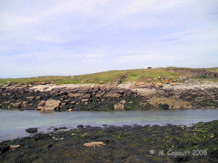
Île Melon menhirs submitted by thecaptain on 25th Jul 2009. View of Ile Melon from the end of the little harbour wall on the mainland.
The remains of two menhirs can be seen to the left of the picture, while the remaining dolmen is at the top of the island.
(View photo, vote or add a comment)
Log Text: This is frustrating. There is only 15 metres of water between me and the island from where I sit, but the tide is coming in and the island is not going to get any nearer. There is a dolmen on top of the island, and there are also at least two menhirs further down to the south of the island, and looking towards the shore. I believe that there was once a large menhir here also, which was blown up during the war. Perhaps a swim is needed !
Kergadiou Menhirs
Trip No.203 Entry No.500 Date Added: 27th May 2020
Site Type: Standing Stones
Country: France (Bretagne:Finistère (29))
Visited: Yes on 20th Jun 2005. My rating: Condition 5 Ambience 4 Access 4

Kergadiou menhirs submitted by thecaptain on 8th Jul 2006. Kergadiou menhir 2 is another king sized menhir, 11 metres long, which unfortunately is not standing upright, but leaning at a very shallow angle.
It is perfectly smoothed into an extremely flat face on its upper surface, while the lower surface is still rough
(View photo, vote or add a comment)
Log Text: The two menhirs of Kergadiou are a fine place to visit, and fairly easily found in a field a couple of kilometres north of the Aber Ildut estuary. From these two giant menhirs, it is possible to see the Kerloas menhir when the modern trees are not in leaf, and the sightline over the Kerloas menhir is perpendicular to the midsummer sunrise. Coincidence ?
Kergadiou menhir 1 is a really magnificent monster menhir, 8.8 metres tall, and the most beautifully and perfectly smoothed and shaped menhir there is. Just 80 metres away to the northeast is its neighbour, another king sized menhir which unfortunately is not standing upright, but leaning at a very shallow angle. It is perfectly smoothed into an extremely flat face on its upper surface, while the lower surface is still rough, which leads to conjecture that it has perhaps never stood, and is left here unfinished. An alternate viewpoint is that it stood as a rough stone, and fell while being pounded into its smoothed and flattened shape, perhaps in preparation for some carvings. This menhir is 11 metres in length, so would have probably stood to the same height as its neighbour.
What a tremendous place.
Lagatjar alignements
Trip No.203 Entry No.498 Date Added: 27th May 2020
Site Type: Stone Row / Alignment
Country: France (Bretagne:Finistère (29))
Visited: Yes on 19th Jun 2005. My rating: Condition 4 Ambience 4 Access 5

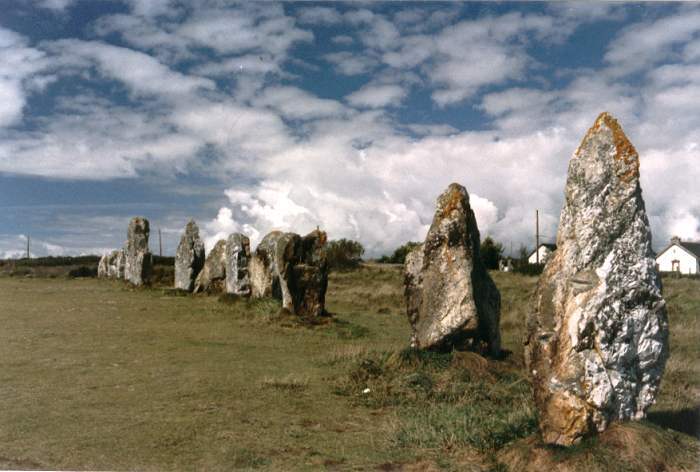
Lagatjar Alignements submitted by thecaptain on 18th Oct 2004. Lagatjar Alignements.
West of the fishing town of Camaret, in the far west of the Crozon Peninsula, Finisterre Brittany.
If memory serves me right, these stones form part of a sort of large stone square.
(View photo, vote or add a comment)
Log Text: The Lagatjar alignements are an intriguing arrangement of stones, mostly consisting of large white quartz blocks on open common land, just to the east of the fishing town of Camaret. There are probably over a hundred stones, mostly aligned into three lines, but there are some outliers as well.
The longest line is over 200 metres in length and has an orientation of 037°. From this line are two rows of larger blocks, heading off at right angles on bearing 317° for the northern row, which is approximately straight and 60 metres in length. The southern row is about 50 metres away, and heads off at 315°, but curves towards the west away from the baseline. Perhaps these two rows once joined up to form a horseshoe ?
South of the main line are three large grey stones, a single one at the west and a pair to the east. These three stones are aligned with each other. There are lots of orchids flowering here, which seems a bit late in the year.
Kerloas Menhir
Trip No.203 Entry No.499 Date Added: 27th May 2020
Site Type: Standing Stone (Menhir)
Country: France (Bretagne:Finistère (29))
Visited: Yes on 19th Jun 2005. My rating: Condition 5 Ambience 5 Access 4

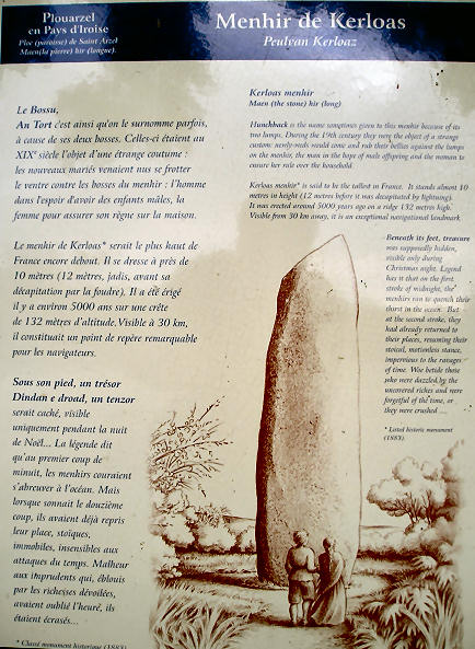
Kerloas menhir submitted by thecaptain on 23rd Jun 2006. Kerloas menhir noticeboard.
Unfortunately theres lots of writing, so it comes out very small !
(View photo, vote or add a comment)
Log Text: What a fantastic stone, and easily found near to the old D.5 road to the east of Plouarzel due to many signposts to it. This is the biggest standing menhir in Europe, if not the world, at nearly 10 metres tall, and has lost the top 2 metres after a lightning strike! It towers above all around, and standing as it does on top of a hill, it can be seen from 30 kilometres away.
The stone, which is not local and has been brought to this hilltop site from more than 2.5 kilometres away near the Aber Ildut estuary, has been beautifully shaped, and tapers both into the ground, and up to a point. On the two "thin" sides of the stone are round humps, about 20 cm in diameter about belly high above the ground.
This stone of course has many legends, such as treasure buried beneath it, going to drink at the ocean on the strike of 12:00 on Christmas night, and that newly wed couples should come here on their wedding night to rub the stone lumps for a good future and fertility. In fact, many wedding parties still come here to this day in order to perform this ritual.
It was a pity it was cold and late when I visited, and not good light for photographs. I feel I would like to stay here a while, it has a lovely atmosphere. Maybe I will come back tomorrow.
Dolmen de la Pointe de Lost Marc'h
Trip No.203 Entry No.497 Date Added: 27th May 2020
Site Type: Chambered Cairn
Country: France (Bretagne:Finistère (29))
Visited: Yes on 19th Jun 2005. My rating: Condition 2 Ambience 4 Access 3

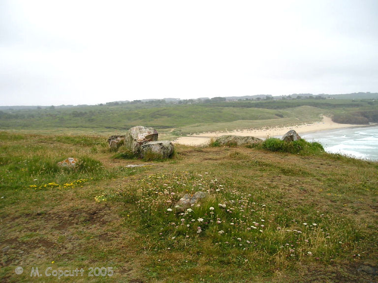
Dolmen de la Pointe de Lost Marc'h submitted by thecaptain on 1st Aug 2009. On the headland there is what appears to be the remains of some sort of cairn and burial chamber on the top. It wouldn't be unusual for one to be in such a place.
There are 6 stones still sticking out of the ground here, and stumps of others to be seen, which sort of make a rectangle inside a circular cairn.
(View photo, vote or add a comment)
Log Text: Just below the big Lostmarc'h headland with the alignements on top, there is a smaller headland which has been defended from the mainland by the creation of two rows of massive banks and ditches protecting it.
On the headland apart from the inevitable remains of a chapel of some sort, there is also what appears to be the remains of some sort of cairn and burial chamber on the top. It wouldnt be unusual for one to be in such a place. There are 6 stones still sticking out of the ground here about 2.5 metres apart from each other, and stumps of others to be seen, which sort of make a rectangle inside a circular cairn.
It is very windblown here today, and misty which is a bit of a shame. The views would be tremendous on a clear day.
Oppidum de la Pointe de Lostmarc'h
Trip No.203 Entry No.496 Date Added: 27th May 2020
Site Type: Promontory Fort / Cliff Castle
Country: France (Bretagne:Finistère (29))
Visited: Yes on 19th Jun 2005. My rating: Condition 3 Ambience 4 Access 3

Oppidum de la Pointe de Lostmarc'h submitted by thecaptain on 1st Aug 2009. Just below the big Lostmarc'h headland with the alignements on top, there is a smaller headland which has been defended from the mainland by the creation of two rows of massive banks and ditches protecting it.
(View photo, vote or add a comment)
Log Text: Just below the big Lostmarc'h headland with the alignements on top, there is a smaller headland which has been defended from the mainland by the creation of two rows of massive banks and ditches protecting it.
On the headland apart from the inevitable remains of a chapel of some sort, there is also what appears to be the remains of some sort of cairn and burial chamber on the top. It wouldn't be unusual for one to be in such a place. There are 6 stones still sticking out of the ground here about 2.5 metres apart from each other, and stumps of others to be seen, which sort of make a rectangle inside a circular cairn.
It is very windblown here today, and misty which is a bit of a shame. The views would be tremendous on a clear day.
Alignement de Lostmarc'h 1
Trip No.203 Entry No.495 Date Added: 27th May 2020
Site Type: Stone Row / Alignment
Country: France (Bretagne:Finistère (29))
Visited: Yes on 19th Jun 2005. My rating: Condition 3 Ambience 4 Access 3

Alignement de Lostmarc'h 1 submitted by thecaptain on 2nd Aug 2009. What I first found of the Lostmarc'h alignements, on top of a headland overlooking the Atlantic Ocean, was a line of stones running across the headland.
There are many other stones laying about, perhaps the remains of other rows.
(View photo, vote or add a comment)
Log Text: What I could find of the Lostmarc'h alignements, on top of a headland overlooking the Atlantic Ocean with a fine surf beach below to the south, was a line of eight stones aligned at an angle of 060°/240° running across the headland. None of the stones are much more than a metre in height, and they are spaced about 6 metres apart from each other. There are several other stones laying about, perhaps the remains of other rows.
Further out on the headland are a lot more stones at N48.2150° W4.5561°. Its hard to make out any clear pattern, but its possibly the remains of at least 4 rows. Further stones can be seen dotted about all over the place. Perhaps this was once a big important centre.
Lostmarc'h menhir
Trip No.203 Entry No.494 Date Added: 27th May 2020
Site Type: Standing Stone (Menhir)
Country: France (Bretagne:Finistère (29))
Visited: Yes on 19th Jun 2005. My rating: Condition 3 Ambience 4 Access 3

Lostmarc'h menhir submitted by thecaptain on 2nd Aug 2009. Lostmarc'h menhir stands in a commanding position on a headland overlooking the Atlantic Ocean, close to the Lostmarc'h alignments.
(View photo, vote or add a comment)
Log Text: Now, this is better, on top of a headland overlooking the Atlantic Ocean with a fine surf beach below to the south. The menhir is about 2.8 metres tall and in a commanding position, although not at the top, and as a result has a much better view. It can be seen from miles around coming from the south.
Dolmen de Rostudel
Trip No.203 Entry No.493 Date Added: 27th May 2020
Site Type: Burial Chamber or Dolmen
Country: France (Bretagne:Finistère (29))
Visited: Yes on 19th Jun 2005. My rating: Condition 3 Ambience 3 Access 3
Dolmen de Rostudel submitted by thecaptain on 19th Jan 2007. This little dolmen is out near the southern tip of the Crozon peninsula, but a right pain to find and get to, even though it is just 50 metres from the roadside.
It's surrounded by vicious gorse and brambles which ripped my shirt.
(View photo, vote or add a comment)
Log Text: This is a nice enough little dolmen, but a right bugger to find and get to, even though it is just 50 metres from the roadside. Firstly there was nowhere to park nearby, and once you have parked and walked back, the path to the dolmen is badly overgrown with the now obligatory ferns, gorse and blackthorn. Once I managed to get to it, the dolmen has a 2.5m by 2m capstone sitting nicely on three support stones and some vicious brambles which have just ripped my shirt. Ouch! Now to fight the gorse again.
Dolmen de Kerdreux
Trip No.203 Entry No.491 Date Added: 27th May 2020
Site Type: Burial Chamber or Dolmen
Country: France (Bretagne:Finistère (29))
Visited: Yes on 19th Jun 2005. My rating: Condition 2 Ambience 3 Access 3
Dolmen de Kerdreux submitted by thecaptain on 20th Jan 2007. Kerdreux dolmen out on the beautiful Crozon peninsula.
There are traces of its mound, perhaps with a stone surround. In the centre of the mound is the little dolmen with a broken capstone.
(View photo, vote or add a comment)
Log Text: Remains of this little dolmen can be found a couple of hundred metres down the track to the west of the hamlet, and then right along the signed footpath. There are traces of its mound, perhaps with a stone surround. In the centre of the mound is the little dolmen with a broken capstone, but one piece is still sitting on a couple of side supports with a chamber underneath it. It is marked on my maps as a menhir, and is a pleasant little find.
Dolmen de Pen-an-Run
Trip No.203 Entry No.489 Date Added: 27th May 2020
Site Type: Burial Chamber or Dolmen
Country: France (Bretagne:Finistère (29))
Visited: Yes on 19th Jun 2005. My rating: Condition 3 Ambience 3 Access 4
Dolmen de Pen-an-Run submitted by thecaptain on 20th Jan 2007. This is a little dolmen on the Crozon Peninsula with a 2.5m by 2.5m capstone sitting on three support slabs, making up part of a hedge.
(View photo, vote or add a comment)
Log Text: This is a little dolmen with a 2.5m by 2.5m capstone sitting on three support slabs, making up part of a hedge. It's about 100 metres from the roadside along a track and signposted.
Menez Lié Dolmen
Trip No.203 Entry No.488 Date Added: 26th May 2020
Site Type: Burial Chamber or Dolmen
Country: France (Bretagne:Finistère (29))
Visited: Yes on 18th Jun 2005. My rating: Condition 3 Ambience 4 Access 3
Menez Lié dolmen submitted by thecaptain on 22nd Jan 2007. This little dolmen sits on the south western slopes of Menez Hom, seen in the background.
(View photo, vote or add a comment)
Log Text: This is a pleasant little dolmen on the south western slopes of Menez Hom. It has a 2.5m by 2m capstone sitting on one large backstone and three smaller side stones. At first view from the road it looks lost in the middle of a field of wheat, but there is a footpath to it around the edge of the field, and a little clearing is left around it.
Tréboul menhir
Trip No.203 Entry No.487 Date Added: 26th May 2020
Site Type: Standing Stone (Menhir)
Country: France (Bretagne:Finistère (29))
Visited: Yes on 18th Jun 2005. My rating: Condition 3 Ambience 2 Access 5
Tréboul menhir submitted by thecaptain on 21st Jan 2007. The two metre tall Tréboul menhir is found in the outskirts of the town of Douarnenez, beside a roundabout near to the old lavoirs.
(View photo, vote or add a comment)
Log Text: The two metre tall Tréboul menhir is found in the outskirts of the town of Douarnenez, beside a roundabout near to the old lavoirs.
Lesconil allée couverte
Trip No.203 Entry No.486 Date Added: 26th May 2020
Site Type: Passage Grave
Country: France (Bretagne:Finistère (29))
Visited: Yes on 18th Jun 2005. My rating: Condition 5 Ambience 4 Access 4

Lesconil allée couverte submitted by paulcall on 21st May 2009. Another general view of this lovely allee couverte in Finistere. GPS 48.09192 N 4.37940 W
(View photo, vote or add a comment)
Log Text: Lesconil allée couverte is easy to find near the village of Lesconil, as it is signposted from the main D.7 road, and with its own little parking area. This is one monument round here that they do want you to visit, unlike most which seem sadly neglected. This is an excellent place, and no doubt the best preserved of the eight known Arc Bouttée style allée couvertes, where the two rows of side stones lean together, rather than having a row of capstones on top.
The chamber is about 14 metres in length, slightly curved, and facing south of southeast at a bearing of 155°, similar to its neighbour at Kerbalannec. The large side slabs range in size up to about 3 metres in height, the largest being in the middle, the smallest at the southeastern, open, end. The back end of the passage has a small seperate compartment between the rear stones, and a blocking stone is present. The allée couverte even has most of it's outer surrounding of peristalith stones, although several of these have become scattered.
It's all nicely sheltered in a little wood, which is keeping the burning sun off of me, but it doesn't help for getting good pictures, with very contrasting light and shade. For such a big monument, there is surprisingly little room inside, although tall in places, the style of construction cuts the space right down. Perhaps this is one for the cheapskates !
Kerbalanec Allée Couverte
Trip No.203 Entry No.485 Date Added: 26th May 2020
Site Type: Passage Grave
Country: France (Bretagne:Finistère (29))
Visited: Yes on 18th Jun 2005. My rating: Condition 5 Ambience 3 Access 4

Kerbalanec allée couverte submitted by paulcall on 21st May 2009. A view from the inside looking in the opposite direction
(View photo, vote or add a comment)
Log Text: This allée couverte is easy enough to find to the north of the Kerbalannec farm buildings a couple of hundred metres along a track. The allée couverte makes up part of the field wall, and this has perhaps helped in its preservation.
The chamber is about 12 metres in length, over 2 metres wide and high enough to stand up in, facing south of southeast at 155°. The northwest end is amazingly complete, but the southeast end has suffered some damage, while five of the probable six capstones survive in place. The field to the south is on a much higher level than the field to the north, and on this side the stone slabs of a peristalith have survived, as has the mound. This is a nice monument to visit.
Kastell Koz
Trip No.203 Entry No.484 Date Added: 26th May 2020
Site Type: Promontory Fort / Cliff Castle
Country: France (Bretagne:Finistère (29))
Visited: Yes on 18th Jun 2005. My rating: Condition 3 Ambience 5 Access 4
Kastell Koz submitted by theCaptain on 25th Jan 2010. This is a superb cliff castle, made on the beautiful headland of the Pointe de Beuzec jutting north into the Baie de Duarnenez
(View photo, vote or add a comment)
Log Text: This is a superb cliff castle, made on the beautiful headland of the Pointe de Beuzec jutting north into the Baie de Duarnenez. It is defended on its southern side from the mainland with several rows of banks and ditches. The views from here are superb.
Luguenez menhir
Trip No.203 Entry No.483 Date Added: 26th May 2020
Site Type: Standing Stone (Menhir)
Country: France (Bretagne:Finistère (29))
Visited: Yes on 18th Jun 2005. My rating: Condition 3 Ambience 3 Access 4
Luguenez menhir submitted by theCaptain on 25th Jan 2010. About three metres in height, this nicely shaped menhir is getting lost in the hedges.
(View photo, vote or add a comment)
Log Text: More than three metres in height, this nicely shaped menhir is getting lost in the hedges of the little lane which runs to the coast behind and to the north of the farm. Not far from here are superb views over the Baie de Duarnenez and the wonderful cliffs all around, including the cliff castle of Kastell Koz just to the east.
Chapelle de Lannourec stèle
Trip No.203 Entry No.481 Date Added: 26th May 2020
Site Type: Standing Stone (Menhir)
Country: France (Bretagne:Finistère (29))
Visited: Yes on 18th Jun 2005. My rating: Condition 3 Ambience 4 Access 5
Chapelle de Lannourec stèle submitted by theCaptain on 21st Dec 2010. The octagonal shaped Iron Age granite stèle seen here in its setting below the Chapelle de Lannourec.
(View photo, vote or add a comment)
Log Text: There is an octagonal shaped Iron Age granite stèle about 2 metres tall which can be found just below the Chapelle de Lannourec, and by the springs. It has a large groove cut down one side.
Just below the Chapelle de Lannourec, are several springs and wells. This is obviously a very old sacred place, with its remaining sprngs, and stèle to be seen, as well as the Chapel.
