Contributory members are able to log private notes and comments about each site
Sites TheCaptain has logged. View this log as a table or view the most recent logs from everyone
Tréboul menhir
Trip No.203 Entry No.487 Date Added: 26th May 2020
Site Type: Standing Stone (Menhir)
Country: France (Bretagne:Finistère (29))
Visited: Yes on 18th Jun 2005. My rating: Condition 3 Ambience 2 Access 5
Tréboul menhir submitted by thecaptain on 21st Jan 2007. The two metre tall Tréboul menhir is found in the outskirts of the town of Douarnenez, beside a roundabout near to the old lavoirs.
(View photo, vote or add a comment)
Log Text: The two metre tall Tréboul menhir is found in the outskirts of the town of Douarnenez, beside a roundabout near to the old lavoirs.
Traonigou alignement de menhirs
Trip No.203 Entry No.505 Date Added: 27th May 2020
Site Type: Stone Row / Alignment
Country: France (Bretagne:Finistère (29))
Visited: Yes on 20th Jun 2005. My rating: Condition 3 Ambience 3 Access 5
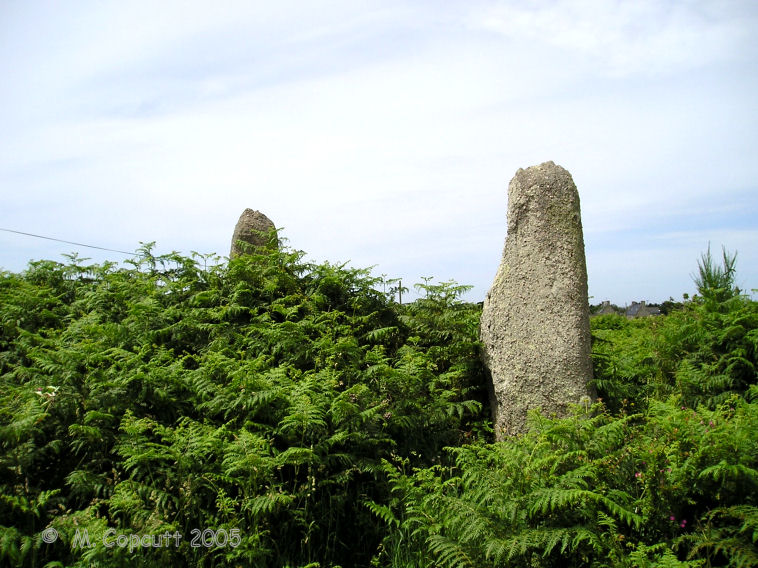
Traonigou alignement de menhirs submitted by thecaptain on 25th Jul 2009. The two standing menhirs are about 4 and 5 metres tall, the two fallen ones becoming lost in the undergrowth.
(View photo, vote or add a comment)
Log Text: Two fallen and two standing menhirs, which are supposedly aligned on the mid summer sunrise. The two standing menhirs are about 4 and 5 metres tall, the two fallen ones becoming lost in the undergrowth. These stones are signposted, and found just beside the road to the east of the hamlet of Traonigou.
Tourenne Gallo-Roman Villa
Trip No.200 Entry No.56 Date Added: 17th Jun 2020
Site Type: Ancient Village or Settlement
Country: France (Midi:Haute-Garonne (31))
Visited: Yes on 22nd Jul 2000. My rating: Access 5
Log Text: Drive west from Toulouse to explore Gascony. Montmaurin, Mielan, Mirande, Condom, St Puy, Fleurance, Mauvezin, Cologne. Fields of sunflowers, beautiful. Stopped by this Roman villa, but it was going to take too long for a proper visit, so satisfied myself with a look over the hedge from the car park.
Tour-ar-Varquez
Trip No.203 Entry No.576 Date Added: 5th Jun 2020
Site Type: Stone Row / Alignment
Country: France (Bretagne:Côtes-D'Armor (22))
Visited: Yes on 25th Jun 2005. My rating: Condition 3 Ambience 3 Access 4

Alignement de Toul-ar-Varquez submitted by thecaptain on 26th May 2007. Two standing and one fallen stone make up this alignment of stones in a field wall to the northeast of Pleubian.
The two standing stones are about 2.5 metres tall.
(View photo, vote or add a comment)
Log Text: Two standing and one fallen stone make up this alignement of stones in a field wall to the northeast of Pleubian. The two standing stones are about 2.5 metres tall, but the fallen one is of indeterminate length and lost in the undergrowth. It is situated about 100 metres across a field beside the road north from St Antoine. The orientation is 065°.
Toul Er Rest Dolmen
Trip No.204 Entry No.59 Date Added: 11th Jul 2020
Site Type: Burial Chamber or Dolmen
Country: France (Bretagne:Morbihan (56))
Visited: Couldn't find on 13th Jul 2005
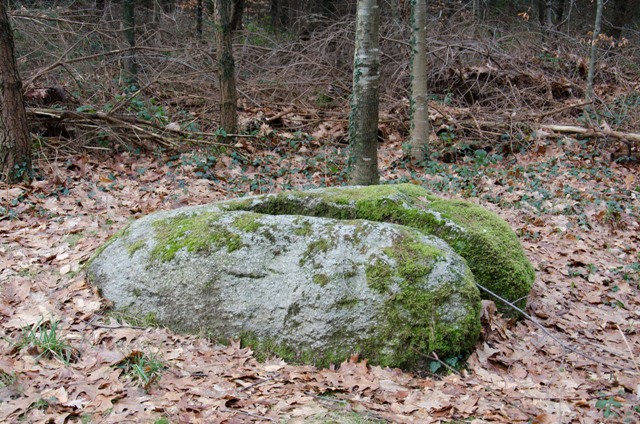
Toul Er Rest dolmen submitted by Ogham on 20th Jan 2012. Not a good example of a dolmen.
(View photo, vote or add a comment)
Log Text: I had a quick look for this, now to be found somewhere in the outskirts and building land of Camors, but could see no signs or obvious place for it to be, so moved on.
Toul an Lann menhir
Trip No.193 Entry No.1 Date Added: 13th Jul 2020
Site Type: Standing Stone (Menhir)
Country: France (Bretagne:Côtes-D'Armor (22))
Visited: Yes on 29th May 1993. My rating: Access 5

Toul an Lann menhir submitted by theCaptain on 28th Feb 2015. A nice slender four metre tall menhir in a field just to the north of the busy D.786 just north of Lannion.
(View photo, vote or add a comment)
Log Text: Cycling camping trip of north Brittany, day 1. Cycle Roscoff, Morlaix, Lannion, Ploumanac'h. Too far. 52 miles. Funny Rocks. Big seafood dinner.
Toul an Lann menhir
Trip No.193 Entry No.21 Date Added: 13th Jul 2020
Site Type: Standing Stone (Menhir)
Country: France (Bretagne:Côtes-D'Armor (22))
Visited: Saw from a distance on 31st May 1993

Toul an Lann menhir submitted by Martin_L on 31st Jan 2009. Toul-al-Lann Menhir.
Situated in a field right North of the Lannion Saint-Michel-en-Grève road (D 786). This fine Menhir is appr. 4m tall, an has a slender shape.
(May 2001)
(View photo, vote or add a comment)
Log Text: Cycling camping trip of north Brittany, day 3. Breton Corniche, Treburden, Lannion, Corniche Armorique to Primel Tregastel. Ace dinner at Diben.
Toul an Lann menhir
Trip No.214 Entry No.15 Date Added: 23rd Jul 2020
Site Type: Standing Stone (Menhir)
Country: France (Bretagne:Côtes-D'Armor (22))
Visited: Yes on 16th Apr 2014. My rating: Condition 4 Ambience 3 Access 5

Toul an Lann menhir submitted by Martin_L on 31st Jan 2009. Toul-al-Lann Menhir.
Situated in a field right North of the Lannion Saint-Michel-en-Grève road (D 786). This fine Menhir is appr. 4m tall, an has a slender shape.
(May 2001)
(View photo, vote or add a comment)
Log Text: A nice slender four metre tall menhir in a field just to the north of the busy D.786 just north of Lannion.
Tottiford Reservoir Row S
Date Added: 15th Sep 2022
Site Type: Stone Row / Alignment
Country: England (Devon)
Visited: Yes on 7th Sep 2022. My rating: Condition 3 Ambience 4 Access 2

Tottiford Reservoir Row S submitted by TheCaptain on 15th Sep 2022. Looking southwards along the double row. I'm sure some of those large stones on the shoreline would have once been part of this row.
Sept 7th 2022
(View photo, vote or add a comment)
Log Text: With the drought of 2022 now exposing the stone circle in Tottiford reservoir, I went down for an exploration. In the southern part of the reservoir, is an obvious large mound, which is all sandy rather than dark mud covered. To the south of the mound, which is elongated in this direction, can be seen remains of a double stone row extending further south into the waters of the lake. It was too wet and muddy for me to get to any of the obviously remaining stones, and the water level of the reservoir was such that some of the stones were surrounded by water, and more could be seen further south and running below the water level. What stones I could see looked regularly spaced. On the sloping lakeshore, there are many large stones laying around, of which I have no doubt many have been removed here from the stone rows.
Tottiford Reservoir Row N
Date Added: 14th Sep 2022
Site Type: Stone Row / Alignment
Country: England (Devon)
Visited: Yes on 7th Sep 2022. My rating: Condition 3 Ambience 4 Access 2
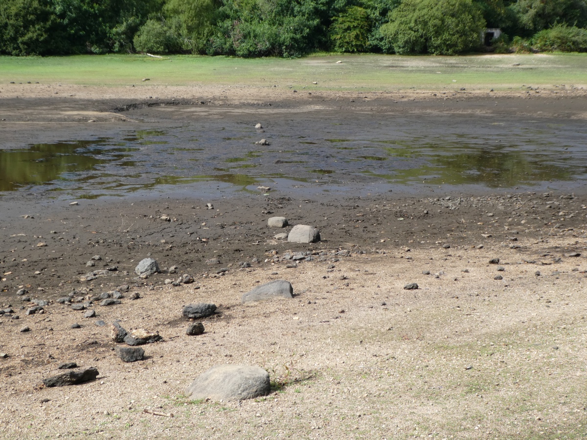
Tottiford Reservoir Row N submitted by TheCaptain on 14th Sep 2022. The northern stone row 7th September 2012. Looking from the eastern shore of Tottiford Reservoir.
(View photo, vote or add a comment)
Log Text: With the drought of 2022 now exposing the stone circle in Tottiford reservoir for only the second time in 150 years, I went down for an exploration. In the southern part of the reservoir, below the footpath causeway bridge, can be seen a single row of stones progressing across the muddy lakebed in a westerly direction from the eastern shore. About 50 metres in length, several regularly spaced large stones can be seen. Trying to get close to the main part of the row, and to walk along its length proved futile, as the mud was very deep and wet. I saw nothing which really resembled a terminal cairn.
Tottiford Reservoir mound
Date Added: 13th Sep 2022
Site Type: Ancient Village or Settlement
Country: England (Devon)
Visited: Yes on 7th Sep 2022. My rating: Ambience 4 Access 2
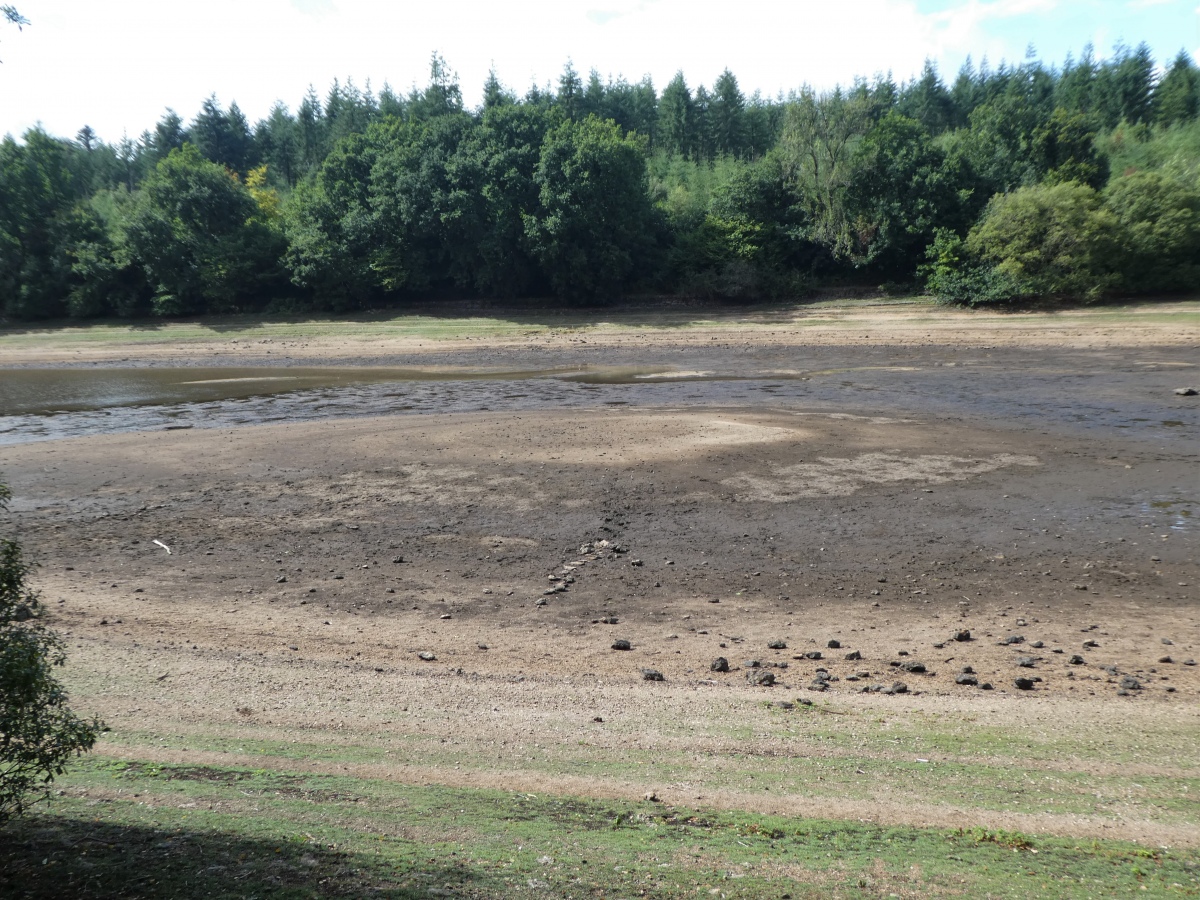
Tottiford Reservoir mound submitted by TheCaptain on 13th Sep 2022. The Mound seen from the eastern shore of Tottiford Reservoir
(View photo, vote or add a comment)
Log Text: In the southern part of the reservoir, is an obvious large mound, which is all sandy rather than dark mud covered. No doubt this has been some form of island at some time. To the northeast of this mound is the remains of a stone sircle, and then further away a single stone row. To the south of the mound, which is elongated in this direction, can be seen remains of a double stone row extending further south into the waters of the lake. To the east of the mound, between it and the eastern shore, can be seen several round piles of stones, which may be ancient cairns, but I am not too convinced, as they look neither big enough, and seem strangely spaced and positioned in what would have been a wet position. Watching the Time Team program later and theyfound much mesolithic flint on the mound, suggesting it had been in use for millennia.
Tottiford Reservoir circle
Date Added: 12th Sep 2022
Site Type: Stone Circle
Country: England (Devon)
Visited: Yes on 7th Sep 2022. My rating: Condition 3 Ambience 4 Access 2

Tottiford Reservoir circle submitted by TheCaptain on 12th Sep 2022. View of the circle seen from the Mound
(View photo, vote or add a comment)
Log Text: With the drought of 2022 now exposing the stone circle in Tottiford reservoir for only the second time in 150 years, I went down for an exploration. Despite overnight storms making the lakebed very wet, slippery and muddy, I was able to walk to the circle, and around most of it.
In the southern part of the reservoir, below the footpath causeway bridge and to the northwest of the obvious lage dry mound, can be seen a few stones of a stone circle. I was able to get across the mud to the nearest stone, and once there it seemed that the circle was arranged around the outer edges of another smaller dry mound. I got to walk around most of the circumference of the circle without too much mud, and noted about 8 to 10 stones, which would have made up a decent circle with regularly spaced stones.
Trying to get across to the large dry mound I had no chance, as there was deep wet mud between the two, presumably an old river course separating the two, so I had to go back the way I had come across the mud from the eastern shore of the reservoir.
Despite getting very wet and muddy feet, and slipping several times, I managed to make it back to dry land without falling flat in the mud! I was really pleased with myself for getting to visit this circle, as I never thought I would even see it, let alone be able to have a proper visit.
Tottiford Reservoir cairns
Date Added: 13th Sep 2022
Site Type: Cairn
Country: England (Devon)
Visited: Yes on 7th Sep 2022. My rating: Condition 2 Ambience 4 Access 2

Tottiford Reservoir cairns submitted by TheCaptain on 13th Sep 2022. On the eastern shore of the lake, can be seen several round piles of stones, which may be ancient cairns, but I am not too convinced.
This one shore side of the double stone row, seen beyond
(View photo, vote or add a comment)
Log Text: To the east of the mound, between it and the eastern shore, can be seen several round piles of stones, which may be ancient cairns, but I am not too convinced, as they look neither big enough, and seem strangely spaced and positioned in what would have been a wet position. There seemes to be a fairly regularly spaced row of these stone piles along much of the eastern shoreline. Watching the Time Team program later and they showed that these were more likely relatively modern stone piles, possibly something to do with when the reservoir was being created.
Tottiford Reservoir
Date Added: 12th Sep 2022
Site Type: Standing Stones
Country: England (Devon)
Visited: Yes on 7th Sep 2022. My rating: Condition 3 Ambience 4 Access 2

Tottiford Reservoir submitted by TheCaptain on 8th Sep 2022. With the drought of 2022 now exposing the stone circle in Tottiford reservoir, I went down for an exploration yesterday. Despite overnight storms making the lakebed very wet, slippery and muddy, I was able to walk to the circle, and around most of it. My footprints make out the circle relatively clearly.
I didn't make notes, and from memory I was able to identify about 10 stones in the mud. Just a quick forst photo uploaded from my phone. In time I will sort out what I have taken.
Des...
(View photo, vote or add a comment)
Log Text: With the drought of 2022 now exposing the stone circle in Tottiford reservoir for only the second time in 150 years, I went down for an exploration. Despite overnight storms making the lakebed very wet, slippery and muddy, I was able to walk to the circle, and around most of it. Despite getting very wet and muddy feet, and slipping several times, I managed to make it back to dry land without falling flat in the mud!
The northern single, and double southern stone rows were clear, but surrounded by too much wet mud to walk along them for any distance.
I was really pleased with myself for getting to visit this circle, as I never thought I would even see it, let alone be able to have a proper visit.
Tossen-Keler Cromlech (1964-2018)
Trip No.203 Entry No.573 Date Added: 5th Jun 2020
Site Type: Stone Circle
Country: France (Bretagne:Côtes-D'Armor (22))
Visited: Yes on 25th Jun 2005. My rating: Condition 3 Ambience 2 Access 5

Tossen-Keler Cromlech (1964-2018) submitted by thecaptain on 24th May 2007. For a reason unknown to me, the 40 metre diameter and 7 metres high Tossen Keler tumulus from Penvénan was excavated and totally removed in about 1960. The horseshoe of stones (cromlech) that surrounded it were moved to a position in a little public garden on the quayside here at the pleasant old port town of Tréguier.
(View photo, vote or add a comment)
Log Text: For a reason unknown to me, the 40 metre diameter and 7 metres high Tossen Keler tumulus from Penvénan was excavated and totally removed in about 1960. The horseshoe of stones (cromlech) that surrounded it were moved to a position in a little public garden on the quayside here at the pleasant old port town of Tréguier. Much of the horseshoe is here, but there was once a few stones with engravings on them, which are now in some museum or other somewhere, and have been replaced here with more modern stones.
I remember this as a pleasant grassy park from my previous visit, but when I revisited in 2005, apart from the grass within it, it is in a massive dusty car and bus park, looking very unloved. Its a shame.
Tossen-Keler Cromlech (1964-2018)
Trip No.214 Entry No.23 Date Added: 5th Jun 2020
Site Type: Stone Circle
Country: France (Bretagne:Côtes-D'Armor (22))
Visited: Yes on 17th Apr 2014. My rating: Condition 3 Ambience 2 Access 5

Tossen-Keler Cromlech (1964-2018) submitted by thecaptain on 25th May 2007. The cromlech that once surrounded Tossen Keler tumulus have been moved to the quayside at the pleasant old port town of Tréguier.
Much of the horseshoe is here, but there was once a few stones with engravings on them, which are now in some museum or other somewhere, and have been replaced here with more modern stones.
(View photo, vote or add a comment)
Log Text: Following lunch in the old town at Treguier we were then heading north along the river to go and sort out the Roche Jaune menhir quandary, so first did a little detour by dropping down from the old town to the quayside for a quick look at the Tossen Keler cromlech.
Poor thing is looking very unloved today, with vehicles parked all around it and various funfair or market stalls nearby. In this situation, it looks not much more than a load of big stones used to divide up the quayside into carpark, boatyard, and other areas. What a shame. Dad was asking why it has been moved here, and I have to say, I still have absolutely no idea.
Tossen-Keler Cromlech (1964-2018)
Trip No.195 Entry No.41 Date Added: 5th Jun 2020
Site Type: Stone Circle
Country: France (Bretagne:Côtes-D'Armor (22))
Visited: Yes on 25th Jun 1995. My rating: Access 5

Tossen-Keler Cromlech (1964-2018) submitted by thecaptain on 25th May 2007. The cromlech that once surrounded Tossen Keler tumulus have been moved to the quayside at the pleasant old port town of Tréguier.
Much of the horseshoe is here, but there was once a few stones with engravings on them, which are now in some museum or other somewhere, and have been replaced here with more modern stones.
(View photo, vote or add a comment)
Log Text: Cross Channel sailing trip from Plymouth, after a 19 hour crossing in rough conditions we berthed in Treguier for some well deserved rest and relaxation. The remains of this cromlech have been positioned on the quayside.
Tormarton 1
Date Added: 28th Aug 2023
Site Type: Long Barrow
Country: England (Gloucestershire)
Visited: Yes on 30th Sep 2022

Tormarton 1 submitted by dooclay on 28th Aug 2022. unploughed (currently) area in which the barrow is located - from the road
(View photo, vote or add a comment)
Log Text: Day out walking and stopped for a quick look here on the way home. The field has been harvested, leaving the long raised lump in the ground standing proud. No obviously easy way into the field, so I satisfied myself with a view from the road.
Toms Hill
Date Added: 29th Oct 2019
Site Type: Multiple Stone Rows / Avenue
Country: England (Somerset)
Visited: Yes on 15th Jun 2017
Toms Hill submitted by TheCaptain on 15th Jun 2017. This stone setting in the wilds of Exmoor is a 6 stone rectangle, or two rows of three stones arranged like the dots on a domino.
(View photo, vote or add a comment)
Log Text: None
Tomnaverie
Date Added: 29th Oct 2019
Site Type: Stone Circle
Country: Scotland (Aberdeenshire)
Visited: Yes on 28th Jul 2017
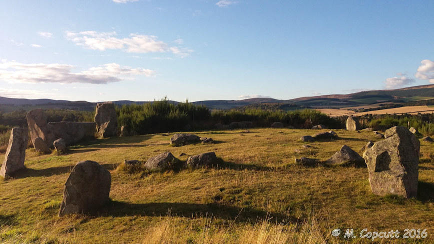
Tomnaverie submitted by TheCaptain on 28th Jul 2017. Tomnaverie stone circle. Glorious in the low sunlight of an October afternoon.
(View photo, vote or add a comment)
Log Text: None
