Contributory members are able to log private notes and comments about each site
Sites TheCaptain has logged. View this log as a table or view the most recent logs from everyone
Allée Couverte d'Haye d'Ectot
Trip No.201 Entry No.20 Date Added: 25th Mar 2020
Site Type: Passage Grave
Country: France (Normandie:Manche (50))
Visited: Couldn't find on 22nd Nov 2004
Allée Couverte d'Haye d'Ectot submitted by TheCaptain on 10th Feb 2017. Carl Ashcroft sends us this picture with the following description.
I have tried to find the allee couverte at La Haye d'Ectot but could not using the location on the map on your site which is just off the D130. I looked around the area for a whole morning. Unfortunately the Mairie is closed until January. However I did bump into a man out hunting who directed me to what he believed was the correct site in a different valley further north over the other side of the valley and closer to the spr...
(View photo, vote or add a comment)
Log Text: To the south of Moitiers d'Allonne is the community of La Haye D’Ectot, which supposedly has its own Allée Couverte, which is often confused with the above. Not marked on any maps I have, I called in at the village admin centre, at this time of day now closed. Outside this was the community map and footpath guide with places of interest marked on it, but I could find no reference to any megalithic monument.
Pierres Tournantes (Néretz)
Trip No.201 Entry No.17 Date Added: 25th Mar 2020
Site Type: Standing Stones
Country: France (Normandie:Manche (50))
Visited: Couldn't find on 22nd Nov 2004
Log Text: Marked on the IGN Top 25 map as being beside a lane in a wooded area near to the Château de Néretz just to the west of the village of Teutheville-Hague, are these two menhirs, said to be 3 metres in height. However, the lane shown on the map turned out to be a gated private driveway, and so I spent no further time looking for these stones.
Galerie des Forges
Trip No.201 Entry No.9 Date Added: 25th Mar 2020
Site Type: Passage Grave
Country: France (Normandie:Manche (50))
Visited: Couldn't find on 22nd Nov 2004
Log Text: The remains of a third Allée Couverte said to be found to the northeast of Rocheville, in the Bois de la Tombette, at the foot of a hill northeast of a track called La Chasse-aux-Forges, but which are difficult to find.
Well, with my luck at finding these Normandie megaliths, and with a full day planned for hunting down other sites, I drove past the suggested area in the vain hope of seeing a signpost or similar (some chance!) but in the absence of which I spent no more time looking. The Allée Couverte is reported to be 16 metres in length, with an east west aspect, width and height 1 metre, closed at the east, open to the west.
Allée Couverte de Câtillon
Trip No.201 Entry No.8 Date Added: 25th Mar 2020
Site Type: Passage Grave
Country: France (Normandie:Manche (50))
Visited: Couldn't find on 22nd Nov 2004
Log Text: The remains of a second Allée Couverte is said to exist to the southeast of Rocheville, a few hundred yards from the Allée Couverte de la Petite Roche, just outside the Bois de la Grosse Roche, near the hamlet of Catillon.
It is said to be 17metres in length, southwest to northeast aspect, with a side entrance, and also with a dolmen type structure at the northeastern end. I had a good look round all the lanes and trackways in the Catillon area, but could not find anything. The one person I found to ask knew nothing of it.
Is it possible that this monument has been destroyed ?
Garn Turne
Date Added: 3rd Nov 2019
Site Type: Chambered Tomb
Country: Wales (Pembrokeshire)
Visited: Couldn't find on 5th Oct 2015

Garn Turne submitted by steveco on 24th Feb 2002. Garn Turn Burial Chamber SM979272.
(View photo, vote or add a comment)
Log Text: Despite there being a few places to park nearby, I could find no way into the relevant field to have a look at this interesting sounding site, which is not clearly marked on the maps.
Bray Down Cairns
Date Added: 8th Oct 2024
Site Type: Cairn
Country: England (Cornwall)
Visited: Saw from a distance on 10th Aug 2024

Bray Down Cairns submitted by dooclay on 16th Jul 2022. The larger Cairn to the West
(View photo, vote or add a comment)
Log Text: On the way home from Padstow on a grey mizzley day, park at Bowithick for a walk to the top of Buttern Hill to see its cairns and the stone row. I am feeling weary, and the weather is not good, so rule out a climb to the top of Bray Down as well, but can clearly see one or two cairns on the top.
Dolmens de Bignon
Trip No.203 Entry No.231 Date Added: 10th Jul 2024
Site Type: Burial Chamber or Dolmen
Country: France (Aquitaine:Gironde (33))
Visited: Saw from a distance on 3rd Jun 2005
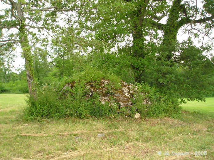
Dolmens de Bignon submitted by thecaptain on 9th Jan 2006. Supposedly there is one large allée-couverte and two simple dolmens to be found, and I must have spent over an hour looking along all tracks and in all fields here.
The best I found is this pile of stones in the middle of a field - could it be one of the small dolmens under there ?
(View photo, vote or add a comment)
Log Text: I knew things were going too well this morning. I found Frontenac, and from there I eventually found Bignon, but after much searching and some very difficult to understand directions from an old lady living near the farm (they are very big, and only 800 metres away) I could find no signs of the three dolmens here. Supposedly there is one large allée-couverte and two simple dolmens to be found, and I must have spent over an hour looking along all tracks and in all fields. Perhaps they are deep in some woods beside the stream.
Carn Lês Boel
Date Added: 17th Jul 2023
Site Type: Promontory Fort / Cliff Castle
Country: England (Cornwall)
Visited: Saw from a distance on 14th Jun 2023
Carn Lês Boel submitted by JimChampion on 29th Aug 2008. August 2007. View across Mill Bay towards the Carn Lês Boel headland. The shallow inner ditch and bank are quite clearly highlighted by the low evening sunlight - look just above the shadowy chasm. There is a narrower, fainter outer ditch that reaches to the top left of the chasm - possibly an unfinished outer defence.
(View photo, vote or add a comment)
Log Text: Walk from St Levan along the coast path, through Porthgwarra and out to Gwennap Head. Keep going right round to Carn Barra where I stop for my pasty, overlooking Zawn Kellys to Carn Lês Boel and Lands End. I spend ages watching the flocks of seabirds on the sea, no doubt all above shoals of fish, fulmars soaring around in the coves and their nests on the cliffs, and lots of choughs busying themselves between feeding on the clifftops and taking food to their nests on the cliffs. Its great to see the choughs back here again. Fabulous.
Roundy Park settlement
Date Added: 5th Jun 2022
Site Type: Ancient Village or Settlement
Country: England (Devon)
Visited: Saw from a distance on 3rd May 2022
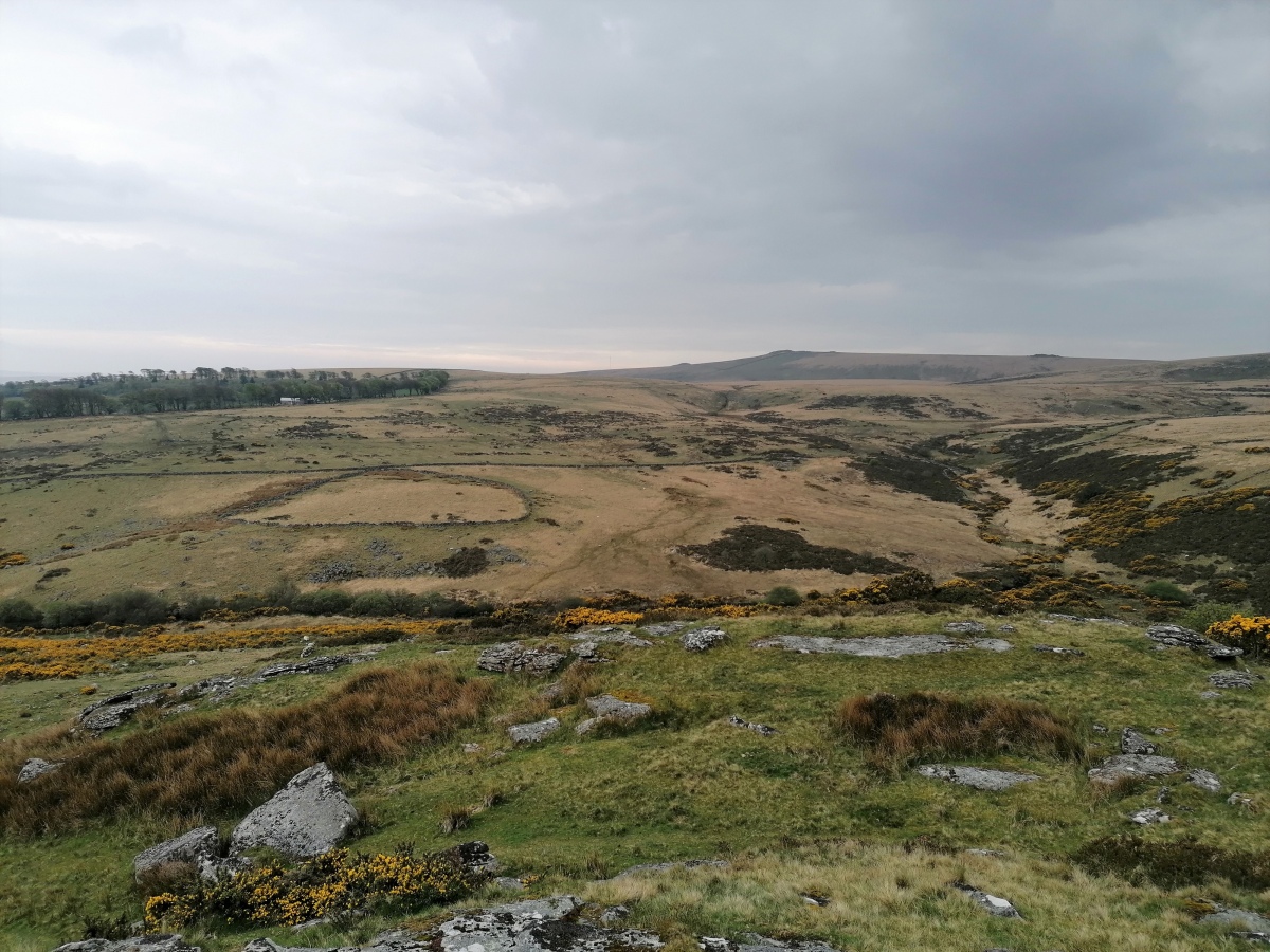
Roundy Park settlement submitted by TheCaptain on 5th Jun 2022. Roundy Park settlement seen clear on the other side of the East Dart valley from Hartland Tor.
(View photo, vote or add a comment)
Log Text: I now try to walk south from the Beehive Hut along the marked bridleway beside the Dart, but its hard going, very rough and largely overgrown, I find it to be much easier higher up on the moorland. South over the top of Hartland Tor with good views south towards Bellever Tor and Roundy Park settlement clear on the other side of the river. Onwards down to the Dart again, through the Hartyland estate to Postbridge, having a look at the old clapper bridge before getting a pint of Jail Ale in the welcoming East Dart Hotel bar.
Buckholt Wood
Date Added: 23rd Oct 2021
Site Type: Chambered Tomb
Country: England (Gloucestershire)
Visited: Saw from a distance on 14th Mar 2009. My rating: Condition 2 Ambience 2 Access 4
Buckholt Wood submitted by 4clydesdale7 on 17th Jun 2011. Fairly easy to find - near entrance to overspill car park for Woodchester Mansion - if you miss the Barrow which is not that conspicuous then look for the Glider Winch at the W end of the Airfield
(View photo, vote or add a comment)
Log Text: The remains of this badly damaged Long Barrow with possible Chambered Tomb can today be seen as a slight raise in the ground at the end of the Nympsfield Gliding Club – today to be seen just behind the winching equipment. This site has been badly damaged in the past by ploughing. I found nowhere obvious to park while driving north, and thought I’d come back later in the day, but didn’t. There seems to be a trackway nearby from where a better look could be had.
La Pierre Levée (Graçay)
Trip No.205 Entry No.266 Date Added: 13th Dec 2020
Site Type: Burial Chamber or Dolmen
Country: France (Centre:Cher (18))
Visited: Saw from a distance on 27th Sep 2005
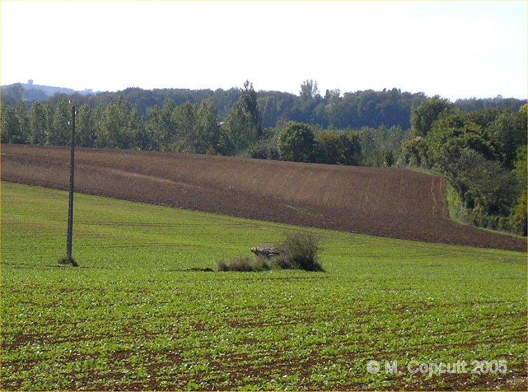
La Pierre Levée (Graçay) submitted by thecaptain on 19th Sep 2008. Just to the south of the D.68 road between Graçay and Nohant-en-Graçay, near to the hamlet of Les Villaines can be seen the remains of this dolmen, about 100 metres from the road in a field.
(View photo, vote or add a comment)
Log Text: Just to the south of the D.68 road between Graçay and Nohant-en-Graçay, near to the hamlet of Les Villaines can be seen the remains of this dolmen, about 100 metres from the road in a field. When I was here, the field had been recently planted, so I did not venture any nearer to the dolmen. It was hard to make out any details, but one capstone can be seen to be still raised above the ground on its supports.
Liniez Tumulus elliptique
Trip No.205 Entry No.265 Date Added: 13th Dec 2020
Site Type: Chambered Tomb
Country: France (Centre:Indre (36))
Visited: Saw from a distance on 27th Sep 2005
Log Text: Just outside the village of Liniez, along the D.926 road towards Vatan, and to the left of the road about a kilometre beyond the dolmen is the remains of a large tumulus. I found it difficult to stop here, and there was lots of fenced off land and woodland, so I didn't get to see this directly.
Les Chateliers
Trip No.205 Entry No.263 Date Added: 13th Dec 2020
Site Type: Ancient Village or Settlement
Country: France (Centre:Indre (36))
Visited: Saw from a distance on 27th Sep 2005
Log Text: At the village of Moulins-sur-Céphons is a reconstruction of an ancient Gallic village. I did not visit.
Plateau de Mons
Trip No.205 Entry No.259 Date Added: 13th Dec 2020
Site Type: Barrow Cemetery
Country: France (Auvergne:Cantal (15))
Visited: Saw from a distance on 26th Sep 2005
Log Text: On top of the plateau is a large collection of earthen barrows dating to the iron age which can be seen from the track.
Menhir de Colobrières 1
Trip No.205 Entry No.249 Date Added: 7th Dec 2020
Site Type: Standing Stone (Menhir)
Country: France (Languedoc:Lozère (48))
Visited: Saw from a distance on 25th Sep 2005
Menhir de Colobrières 1 submitted by TheCaptain on 20th Oct 2010. The large Colobrières menhir seen on the skyline from the road across the top of the Bondons, near Vaissiere, September 2005.
The weather made me not bother to go for the walk to visit it !
(View photo, vote or add a comment)
Log Text: The large Colobrières menhir can be seen on the skyline from the road across the top of the Bondons, near Vaissiere. The weather made me not go for the walk to visit it !
Baraque de l'Air Menhirs
Trip No.205 Entry No.248 Date Added: 7th Dec 2020
Site Type: Standing Stone (Menhir)
Country: France (Languedoc:Lozère (48))
Visited: Saw from a distance on 25th Sep 2005. My rating: Access 4
Baraque de l'Air menhirs submitted by ocdolmen on 5th Aug 2006. Site in Languedoc:Lozère (48)
Baraque de l'Air menhirs, Lozère, France.
(View photo, vote or add a comment)
Log Text: I drove for a look in the rain, I could see another hilltop covered in standing stones, where a possible cromlech has been identified.
Menhirs dit de la Maisonnette 2
Trip No.205 Entry No.247 Date Added: 7th Dec 2020
Site Type: Standing Stone (Menhir)
Country: France (Languedoc:Lozère (48))
Visited: Saw from a distance on 25th Sep 2005. My rating: Access 4
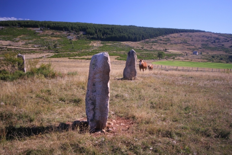
Menhirs dit de la Maisonnette 2 submitted by Aska on 20th Oct 2010. Site in Languedoc: Lozère (48) France
Triangle of menhirs on the hill close to D35 road.
44.41490N,3.63194E
(View photo, vote or add a comment)
Log Text: As I was driving past in the rain, I could see another hiltop covered in standing stones, where a possible cromlech has been identified here.
Menhir de Fraissinel
Trip No.205 Entry No.224 Date Added: 6th Dec 2020
Site Type: Standing Stone (Menhir)
Country: France (Languedoc:Lozère (48))
Visited: Saw from a distance on 25th Sep 2005
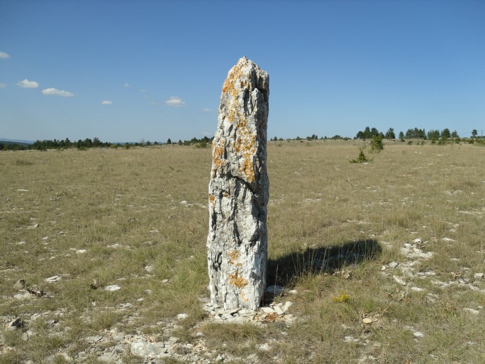
Menhir de Fraissinel submitted by regina on 20th Oct 2011. Site in Languedoc:Lozère (48) France
The menhir is about 2.50m high
N44.43841 E3.49464
(View photo, vote or add a comment)
Log Text: I could find nowhere to park my campervan around here, so ended up turning round and going back, which was easier said than done! However, the menhir standing up on the top of its little hillock can be seen for miles around, and looks to be about 2.5 metres tall.
Menhirs du Col des Faïsses
Trip No.205 Entry No.220 Date Added: 1st Dec 2020
Site Type: Standing Stones
Country: France (Languedoc:Lozère (48))
Visited: Saw from a distance on 24th Sep 2005. My rating: Condition 3 Ambience 4 Access 5

Menhirs du Col des Faïsses submitted by johnstone on 29th May 2018. The big one measures about 2m, in front of the information panels, June 23, 2008
(View photo, vote or add a comment)
Log Text: At the north western end of the section of the Corniche-des-Cévennes along the high Causse near Le Hospitalet, can be seen several other similar looking standing stones.
Oppidum de Nages
Trip No.205 Entry No.196 Date Added: 26th Nov 2020
Site Type: Ancient Village or Settlement
Country: France (Languedoc:Gard (30))
Visited: Saw from a distance on 21st Sep 2005

Oppidum de Nages submitted by thecaptain on 19th Apr 2008. On the top of the hill to the north of Nages are the remains of an oppidum.
This is a nice looking hill rising steeply from the plains, and with what looks to be a sculpted top.
Viewed here from the southwest.
(View photo, vote or add a comment)
Log Text: On the top of the hill to the north of Nages are the remains of an oppidum. This is a nice looking hill rising steeply from the plains, and with what looks to be a sculpted top.
