Contributory members are able to log private notes and comments about each site
Sites TheCaptain has logged. View this log as a table or view the most recent logs from everyone
Dolmen dit Pierre-Levée (Fontaine)
Trip No.202 Entry No.65 Date Added: 29th Mar 2020
Site Type: Burial Chamber or Dolmen
Country: France (Normandie:Orne (61))
Visited: Yes on 2nd May 2005. My rating: Condition 2 Ambience 3 Access 5

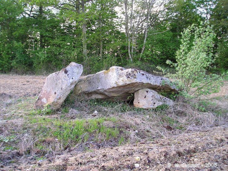
Dolmen dit Pierre-Levée (Fontaine) submitted by thecaptain on 3rd Nov 2005. The much ruined Pierre Levée near to Fontaine-les-Bassets on a fine spring day
(View photo, vote or add a comment)
Log Text: Right beside the road to the west of the village of Fontaine-les-Bassets on the way to Ommoy are the remains of this dolmen. It is hard to make out what exactly the remains consist of. There is one large capstone about 3.5 m by 3 m and about 0.7 m thick leaning up against a solitary remaining support stone on its southeast side. There are a couple of other large slabs laying flat to the ground at the east.
La Pierre Levée (Silly)
Trip No.202 Entry No.67 Date Added: 29th Mar 2020
Site Type: Standing Stone (Menhir)
Country: France (Normandie:Orne (61))
Visited: Yes on 2nd May 2005. My rating: Condition 3 Ambience 2 Access 4

La Pierre Levée (Silly) submitted by thecaptain on 3rd Nov 2005. La Pierre Levée (Silly).
I found it difficult to park nearby, so just stopped for a moment at the side of a fairly busy road to take this picture, which does not do it any justice at all.
(View photo, vote or add a comment)
Log Text: To the southeast of the village of Silly-en-Gouffern and just inside the Forêt-de-Petite-Gouffern can be found this enormous menhir about 40 metres from the roadside. It is more than 6 metres tall and several metres wide with its thickness less than a metre. And the top two metres have been broken off !
When I was here I found nowhere to park a camper van and the stone seemed to be located well within a private area with no direct access.
La Pierre Levée (Echauffour)
Trip No.202 Entry No.69 Date Added: 29th Mar 2020
Site Type: Burial Chamber or Dolmen
Country: France (Normandie:Orne (61))
Visited: Saw from a distance on 2nd May 2005. My rating: Condition 3 Ambience 2 Access 3

La Pierre Levée (Echauffour) submitted by thecaptain on 4th Nov 2005. La Pierre Levée (Echauffour).
Seen in a field of stinking rapeseed, from a busy road.
(View photo, vote or add a comment)
Log Text: About half a kilometre south of the village of Echauffour can be seen in a field to the east of the road the remains of a dolmen of which a large capstone can be seen resting on some uprights.
I could find nowhere to stop nearby so I parked some distance away and walked to try and get a closer look. This is a nasty busy road with lots of lorries thundering past and I found no way into the field and only got a couple of distant shots. I hate the smell of rapeseed and it brings on my asthma but the yellow flowers of it in a distant field made a reasonable background to the pictures helping the stones stand out against their surroundings.
Menhirs dits Les Croûtes
Trip No.202 Entry No.68 Date Added: 29th Mar 2020
Site Type: Standing Stones
Country: France (Normandie:Orne (61))
Visited: Yes on 2nd May 2005. My rating: Condition 3 Ambience 3 Access 4

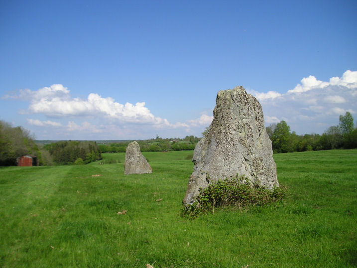
Menhirs dits Les Croûtes submitted by thecaptain on 4th Nov 2005. Les Croûtes are a couple of large (3 metres plus) menhirs stood in a damp field near to the village of Echauffour in Orne.
(View photo, vote or add a comment)
Log Text: A couple of kilometres south of the village of Echauffour can be found a signpost pointing to menhirs along a small track to the east of the road. There is a place to park on this track near the main road and after a couple of hundred metres walk down this track the two menhirs can be seen standing in a field.
Both stones are about 3 metres tall and are spaced about 30 metres apart from each other on an alignment of 055° running down the hill (235° uphill). There is supposed to be a third stone in this alignment and I think I saw it laying under deep undergrowth in the hedge at the top of the field on about an equal spacing although I could not be 100% sure.
La Grosse Pierre (Verneusses)
Trip No.202 Entry No.76 Date Added: 29th Mar 2020
Site Type: Burial Chamber or Dolmen
Country: France (Normandie:Eure (27))
Visited: Yes on 2nd May 2005. My rating: Condition 4 Ambience 4 Access 5

La Grosse Pierre (Verneusses) submitted by thecaptain on 11th Nov 2005. La Grosse Pierre (Verneusses). A nice dolmen largely made from the most wonderful puddingstone slabs.
(View photo, vote or add a comment)
Log Text: A nice simple dolmen right beside the lane just to the east of the hamlet of Verneusses. The large capstone is 4 m by 3.5 m on top of 6 upright support stones. The capstone and one of the upright stones are made from a strange stony conglomerate which has lots of flints in it on one side only. Apparently this dolmen was restored badly nearly two hundred years ago.
Dolmen de la Pierre Couplée
Trip No.202 Entry No.75 Date Added: 29th Mar 2020
Site Type: Burial Chamber or Dolmen
Country: France (Normandie:Orne (61))
Visited: Yes on 2nd May 2005. My rating: Condition 2 Ambience 2 Access 4

Dolmen de la Pierre Couplée submitted by thecaptain on 11th Nov 2005. La Pierre Couplée, Ferté Frênel, is a poor broken and mistreated dolmen, barely left with enough room to survive in its ploughed field.
(View photo, vote or add a comment)
Log Text: The remains of this dolmen are now within a ploughed field just to the northwest of the village of Ferté Frêsnel on the road to Bocquencé. There is a small signpost to the dolmen but as seems almost always in these parts there is nowhere at all to park.
The dolmen is now very badly looked after ploughed right up to the edges and indeed hit with the machinery in one or two places and covered in muck from muckspreading. The large broken capstone is 4 m by 3 m and there are three collapsed support slabs.
Camp Celtique de Bière
Trip No.202 Entry No.64 Date Added: 29th Mar 2020
Site Type: Ancient Village or Settlement
Country: France (Normandie:Orne (61))
Visited: Yes on 2nd May 2005. My rating: Condition 4 Ambience 5 Access 4

Camp Celtique de Bière submitted by thecaptain on 11th Oct 2005. Camp Celtique de Bière, near the village of Merri Bière in Orne, Normandie
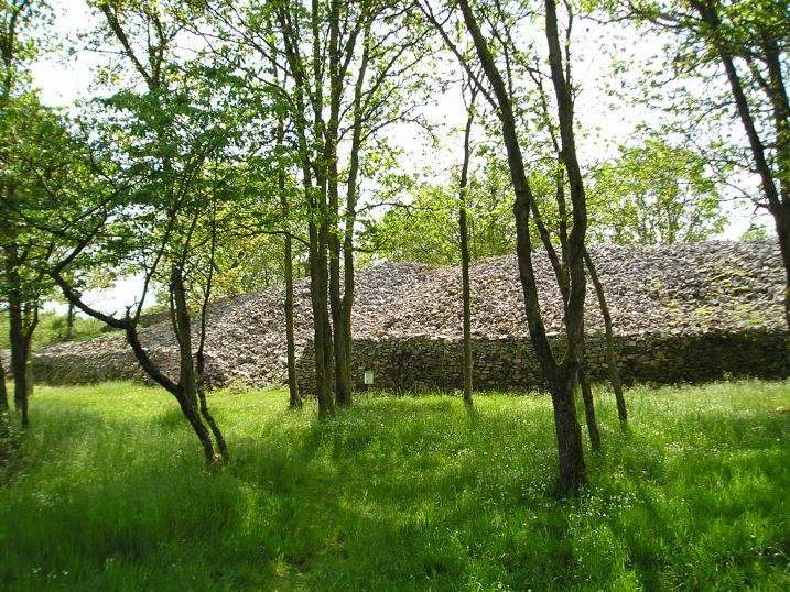
This is a view of the massive southern wall of the northern enclosure, dividing the encampment.
(View photo, vote or add a comment)
Log Text: This is a massive fortified encampment which has been dated back to 4000 BC but with traces of habitation from long before that. The site generally consists of three enclosures on a headland well protected on three sides by steep sided gorges cut by a couple of small streams. The unprotected southern side has three ramparts of various size dates and condition protecting the camp the three ramparts not close together and separating the three enclosures.
It is thought the first encampment was built during the bronze age and was modified at a couple of different times during the Iron Age. The northern rectangular enclosure is the most heavily defended with massive drystone walls thrown up all around particularly at the southern end where the walling is up to 8 metres high. There is the remains of what was once perhaps an entrance through the wall and several of the significant stones used in facing the wall have fossilised trilobites and other marine creatures in them.
It is signposted from nearby and there is a parking area provided a few hundred metres walk to the site. It is now regularly studied and being restored and the enclosed area is now a nature reserve with little signed walks.
Dolmen dit Pierre-aux-Bignes
Trip No.202 Entry No.62 Date Added: 29th Mar 2020
Site Type: Burial Chamber or Dolmen
Country: France (Normandie:Orne (61))
Visited: Yes on 2nd May 2005. My rating: Condition 4 Ambience 3 Access 4

Dolmen dit Pierre-aux-Bignes submitted by thecaptain on 1st Nov 2005. Pierre-aux-Bignes and Tumulus-des-Hogues.
Seen here together down the farmtrack leading to them.
(View photo, vote or add a comment)
Log Text: North of the village of Habloville and signposted from the road its about a 200 metre walk along a track to get to the monument where there are two burial mounds.
The northwestern of the two round mounds is about 15 metres in diameter and about 2 metres high at the edges. Within the mound which has been dug out is the dolmen des Bignes burial chamber. This has a massive capstone (4 metres by 3 metres) held up on 6 uprights with a few other stones scattered around. There is about 1 metre of height between today’s ground and the capstone but I could not determine where any entrance would have been although it would not have been to the west.
The ambience of these burial mounds is spoiled by it obviously used as a place where the local youth (or others) go to have a drink leaving all their detritus behind. There are broken bottles and other rubbish all over the place.
Les Gastines
Trip No.202 Entry No.70 Date Added: 29th Mar 2020
Site Type: Standing Stones
Country: France (Normandie:Orne (61))
Visited: Saw from a distance on 2nd May 2005. My rating: Condition 2 Ambience 3 Access 3

Les Gastines submitted by thecaptain on 9th Nov 2005. Les Gastines menhirs.
Not too long ago a field with at least 4 menhirs in it, but these days seems to have been cleared except for the big one, which can just about be seen here poking out of the top of the dark bush in the middle.
(View photo, vote or add a comment)
Log Text: At the hamlet of La Métairie, a couple of kilometres south of Saint Hilaire-sur-Risle, in Orne, used to be a field with several stones in it including 4 menhirs one of which was more than 4 metres high and had been split by a tree which had grown in a crack in the stone.
Recent fate seems not to have been kind to these stones as when I visited, the field had been cleared of these stones and ploughed over and planted with crops. What appeared to be a bush growing over the top of the ridge was on closer inspection a trimmed tree with signs of a large stone mixed in with it.
I could get no closer to look properly, but at least the large split menhir seems to be in place still. When driving along the lane to the south of the field I saw three large stones and many smaller ones piled within the hedge. Is this the sad fate of Les Gastines ? Succombed to a farmers greed after 5000 years ?
Trun menhir
Trip No.202 Entry No.66 Date Added: 29th Mar 2020
Site Type: Standing Stone (Menhir)
Country: France (Normandie:Orne (61))
Visited: Couldn't find on 2nd May 2005
Log Text: There is a menhir somehow incorporated into a southern corner of the church tower of this village where I stopped right by it to buy food and look at the village maps. How stupid I was to miss this one forgetting its existence only while I was there. Its why I went there ! Guess the lateness of getting my lunch was taking its toll.
Menhir de Boulay-Filleul
Trip No.202 Entry No.74 Date Added: 29th Mar 2020
Site Type: Standing Stone (Menhir)
Country: France (Normandie:Orne (61))
Visited: Saw from a distance on 2nd May 2005

Menhir de Boulay-Filleul submitted by HOMER27000 on 7th Jan 2012. Boulai menhir
Site in Normandie:Orne (61) France
(View photo, vote or add a comment)
Log Text: A menhir in woodland visible just to the west side of the road to L’Aigle a couple of kilometres south of the village. As is becoming typical of round here there is nowhere at all to park on a very busy road. Those damned Normadie ditches alongside all the roads. Couldn’t stop to take a picture and it took miles before I was able to turn round and have another look on the way back.
Dolmen de l'Hôtel-Dieu
Trip No.202 Entry No.80 Date Added: 30th Mar 2020
Site Type: Burial Chamber or Dolmen
Country: France (Normandie:Eure (27))
Visited: Saw from a distance on 3rd May 2005

Dolmen de l'Hôtel-Dieu submitted by thecaptain on 19th Oct 2005. Pierre des Druides, or Hotel Dieu dolmen, near to the village of Les Ventes, seen in its field on a terribly wet morning in May.
(View photo, vote or add a comment)
Log Text: Seen a couple of hundred metres away in the middle of a field just to the northeast of the crossroads at La Trigalle It looks fairly similar to the nearby Pierre Courcoulée.
Menhir dit la Pierre de Gargantua (Neaufles)
Trip No.202 Entry No.78 Date Added: 30th Mar 2020
Site Type: Standing Stone (Menhir)
Country: France (Normandie:Eure (27))
Visited: Saw from a distance on 3rd May 2005

Menhir dit la Pierre de Gargantua (Neaufles) submitted by thecaptain on 19th Oct 2005. Pierre de Gargantua, Neauffles-Auvergny.
Seen at a distance of about 250 metres across fields from the little bridge across the Risle river.
(View photo, vote or add a comment)
Log Text: Seen at a distance of about 200 metres across fields from the little bridge across the Risle river. There wasn’t really anywhere to park and there looked no way to get to the menhir so I contented myself with a long distance shot. It must be nearly 4 metres tall in a large flat pasture beside the river.
Dolmen de la Ferme Brûlée
Trip No.202 Entry No.82 Date Added: 30th Mar 2020
Site Type: Burial Chamber or Dolmen
Country: France (Centre:Eure-et-Loire (28))
Visited: Yes on 3rd May 2005

Dolmen de la Ferme Brûlée submitted by thecaptain on 10th Nov 2005. La Ferme Brûlée dolmen.
Just to the south of Fort Harrouard neolithic settlement, on the banks of the river Eure, is another of these dolmens inside a private garden with lots of keep out signs and security fences. However, it can be seen over the gate, down at the end of the driveway.
(View photo, vote or add a comment)
Log Text: Down by the banks of the river Eure are marked on my map a dolmen and polissoir. I couldn’t park close so parked and walked back from some distance away during which time I got soaked by a torrential downpour. I eventually found a house called Le Dolmen but with lots of keep out signs and security devices. Down the far end of the driveway I could see the dolmen and managed a long distance photo of it part hidden by a van. There was no way I could get any sight of the polissoir which was a shame.
Fort Harrouard
Trip No.202 Entry No.84 Date Added: 30th Mar 2020
Site Type: Ancient Village or Settlement
Country: France (Centre:Eure-et-Loire (28))
Visited: Saw from a distance on 3rd May 2005

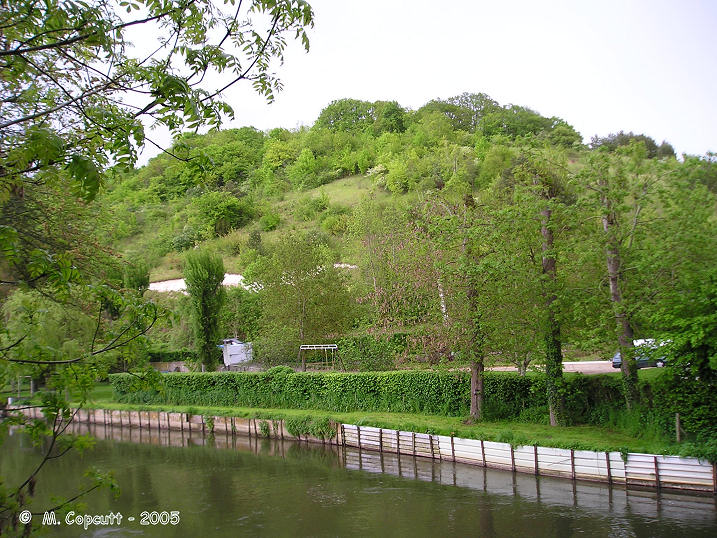
Fort Harrouard submitted by thecaptain on 10th Nov 2005. Fort Harrouard seen above the river Eure.
(View photo, vote or add a comment)
Log Text: This ancient defended settlement is positioned on a steep hillside high above the river Eure near the village of Marcilly-sur-Eure.
La Pierre Courcoulée (Ventes)
Trip No.202 Entry No.79 Date Added: 30th Mar 2020
Site Type: Burial Chamber or Dolmen
Country: France (Normandie:Eure (27))
Visited: Yes on 3rd May 2005. My rating: Condition 3 Ambience 4 Access 4

La Pierre Courcoulée (Ventes) submitted by thecaptain on 19th Oct 2005. La Pierre Courcoulée, which can be found in the forest near to the village of Les Ventes, in Eure.
(View photo, vote or add a comment)
Log Text: This dolmen consists of a giant flinty puddingstone capstone sitting on 4 support stones with a couple more fallen inside. The capstone is about 4 metres by 2.5 metres and well over a metre thick.
It is marked on my ign map but there are no signposts at all on the face of the world. Park where the road from the village of Ventes meets the D60 at Le Haut Bois – there’s plenty of space just to the west of the road at a big entrance area to the forest. Do not walk straight into the forest but take the track to the left (southeast) behind the houses. I just followed this track for about half a mile following my nose at each of the junctions and found the dolmen easily enough. Perhaps some unknown power was guiding me after all my recent failures. After my visit just after I got back into my campervan the heavens opened up and there was a massive thunderstorm. Somebody is on my side today.
Dolmen de la Forge
Trip No.202 Entry No.77 Date Added: 29th Mar 2020
Site Type: Burial Chamber or Dolmen
Country: France (Normandie:Eure (27))
Visited: Yes on 3rd May 2005

Dolmen de la Forge submitted by thecaptain on 6th Nov 2005. Dolmen de la Forge, Rugles.
This dolmen was a nightmare to find. It took me 3 or 4 attempts to negotiate the one way system in the town before finding the right road alongside the river. Then, after I eventually found somewhere to park and walked back about a kilometre, the dolmen was nigh on impossible to spot.
But it is there in a very private garden with double barbed wire fences, a large hedge and guard dogs.
(View photo, vote or add a comment)
Log Text: Having failed to find this after several attempts yesterday, the next day I checked out the position of this dolmen on the ign 1:25000 map in the supermarket and it looked simple to find so thought I’d have another go. Its north of the town on the little road that runs on the west side of the Risle river. Just past the hamlet of La Forge it should be between the very small road and the river.
After I eventually found somewhere to park and walked back about a kilometre the dolmen is nigh on impossible to spot. But there it is in a very private garden with double barbed wire fences a large hedge and guard dogs the dolmen can be spotted through the trees about 70 metres away from the road.
Getting a picture is a different matter! It looks a bit like the one at Verneusses with a large capstone on several supports.
Cul Blanc Dolmens
Trip No.204 Entry No.205 Date Added: 27th Aug 2020
Site Type: Burial Chamber or Dolmen
Country: France (Bourgogne:Saône-et-Loire (71))
Visited: Yes on 3rd May 2005. My rating: Condition 3 Ambience 3 Access 5
Cul Blanc dolmens submitted by thecaptain on 16th Sep 2006. Cul Blanc dolmen 2.
The second dolmen is about 40 metres further down the hillside, and still completely within its mound, making it very difficult to see amongst the bushes.
(View photo, vote or add a comment)
Log Text: Cul Blanc 1: Still within most of its tumulus, this dolmen is on the northern slopes of Mont des Troix Croix, high up above the village of Dezize-les-Maranges at a junction of the tracks. The circular mound is about 15 metres in diameter, and the dolmen is in the middle. The chamber is about 2.5 metres in length by 1.3 metres wide, open to the south and covered with a triangular limestone capstone, of dimensions 3m by 3m by 3m. It was very difficult to find my way to, lots of roads shut for maintenance, and a complete absence of any signs except for all the local vineyards. Supposedly one of two dolmens here.
Cul Blanc 2: Ah, yes, here it is. The second one is about 40 metres further down the hillside, and still completely within its mound, making it very difficult to see amongst the bushes. Probably similar to the first dolmen, the chamber cannot be seen, just the top of the capstone is exposed.
Alignement des Bruyères
Trip No.202 Entry No.81 Date Added: 30th Mar 2020
Site Type: Stone Row / Alignment
Country: France (Normandie:Eure (27))
Visited: Couldn't find on 3rd May 2005

Alignement des Bruyères submitted by HOMER27000 on 21st Apr 2011. Alignement des Bruyères
Site in Normandie:Eure (27) France
(View photo, vote or add a comment)
Log Text: I carelessly missed this alignment of three menhirs by not looking carefully at all the information I had with me. I looked in the village for details but there were none I could find. It is supposedly in a field down near the hamlet of Les Bruyeres. So much for my thinking that some unknown being was helping me out today !
Dolmen dit Gravier de Gargantua 1
Trip No.202 Entry No.85 Date Added: 30th Mar 2020
Site Type: Burial Chamber or Dolmen
Country: France (Normandie:Eure (27))
Visited: Couldn't find on 3rd May 2005
Log Text: Despite a good look around I could find no evidence of either of these. Why oh why do these villages in Normandy not look after and promote these sites ? Not even a map of the area in the village which makes these sites in Eure even more difficult to find than those in the rest of Normandy.
