Contributory members are able to log private notes and comments about each site
Sites TheCaptain has logged. View this log as a table or view the most recent logs from everyone
Pierre Levée au Bois Bouéry
Trip No.205 Entry No.21 Date Added: 14th Oct 2020
Site Type: Burial Chamber or Dolmen
Country: France (Limousin:Haute-Vienne (87))
Visited: Yes on 31st Aug 2005. My rating: Condition 5 Ambience 5 Access 4
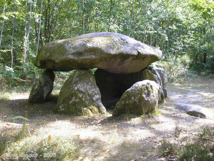
Pierre Levée au Bois Bouéry submitted by thecaptain on 20th Feb 2006. In the forest to the southwest of Saint-Sulpice-les-Feuilles, this lovely dolmen is easily found as it is signposted from the D.2 road, and it resides in a little forest clearing.
(View photo, vote or add a comment)
Log Text: In the forest to the southwest of Saint-Sulpice-les-Feuilles, this dolmen is easily found as it is signposted from the D.2 road, several kilometres to the north. From the road that leads to the dolmen, it is just a hundred metres walk from a parking place, and it resides in a little forest clearing.
The dolmen is quite a big one, made from granite rocks. The capstone is sort of mushroom shaped, and about 5 metres in diameter. It sits on top of 5 support stones, with at least one other fallen, and is about 1.5 metres off the ground. It covers an oval shaped chamber 4 metres by 3 metres internal dimensions with the probable entrance to the east. The support stone at the northern side appears to have engravings on it, and I would put money on the markings not being natural. Near to the ground is a classic palette about 40 cm long pointing towards the right, and above this a classic necklace and breasts, or else a smiley face. I have not seen any reference to there being carvings here.
Marchain Dolmen
Trip No.205 Entry No.20 Date Added: 14th Oct 2020
Site Type: Burial Chamber or Dolmen
Country: France (Poitou:Vienne (86))
Visited: Yes on 31st Aug 2005. My rating: Condition 3 Ambience 3 Access 2

Marchain dolmen submitted by thecaptain on 11th Feb 2006. To the west of the village of Lathus-Saint-Rémy, in the fields near to the hamlet of Marchain, can be found this dolmen. It can be seen across the fields by the crossroads to the south of the hamlet, but I could find no obvious way to get to the dolmen, all the fields being fenced off.
(View photo, vote or add a comment)
Log Text: To the west of the village of Lathus-Saint-Rémy, in the fields near to the hamlet of Marchain, can be found this dolmen. It can be seen across the fields by the crossroads to the south of the hamlet, but I could find no obvious way to get to the dolmen, all the fields being fenced off. It looks to be a fairly simple little dolmen, with a capstone set on top of a few support stones.
Pierre Brune Dolmen
Trip No.205 Entry No.19 Date Added: 14th Oct 2020
Site Type: Burial Chamber or Dolmen
Country: France (Poitou:Vienne (86))
Visited: Couldn't find on 31st Aug 2005
Log Text: A bit further to the south of Pierre-Soupèze along the same little farm road is a farm called Pierre Brune. There are no obvious signs of any dolmen, but there are lumps and bumps in the fields, and piles of stones in the fields.
Dolmen dit Pierre-Soupèze
Trip No.205 Entry No.18 Date Added: 14th Oct 2020
Site Type: Burial Chamber or Dolmen
Country: France (Poitou:Vienne (86))
Visited: Yes on 31st Aug 2005. My rating: Condition 3 Ambience 3 Access 2

Dolmen dit Pierre-Soupèze submitted by thecaptain on 11th Feb 2006. To the southeast of Montmorillon, this dolmen is within a ploughed field, which is very well fenced to keep people out.
From the edge of the farm lane you can see a few stones under some bushes, with a large capstone at an angle on top of a couple of supports.
(View photo, vote or add a comment)
Log Text: To the southeast of Montmorillon, this dolmen is within a ploughed field, which is very well fenced to keep people out. From the edge of the farm lane you can see a few stones under some bushes, with a large capstone at an angle on top of a couple of supports. From certain angles daylight can be seen beneath it. It is possible that there are two dolmen capstones here, or else there are many other large stones dumped here for field clearance.
Dolmen de la Bastière 2
Trip No.205 Entry No.17 Date Added: 14th Oct 2020
Site Type: Burial Chamber or Dolmen
Country: France (Poitou:Vienne (86))
Visited: Yes on 31st Aug 2005. My rating: Condition 2 Ambience 3 Access 4
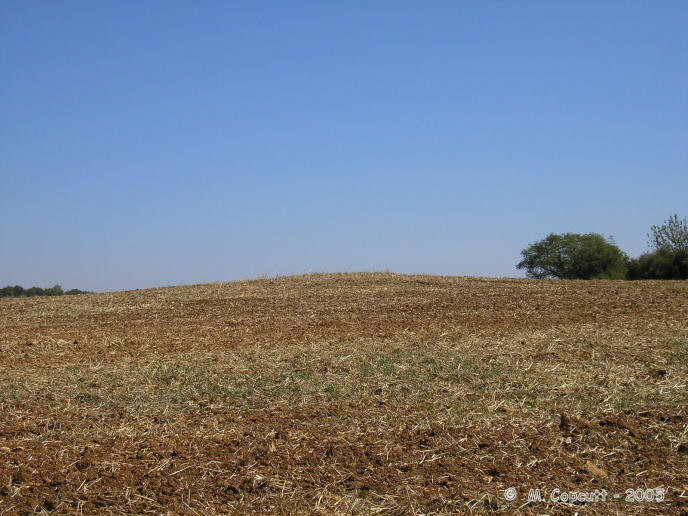
Dolmen de la Bastière 2 submitted by thecaptain on 10th Feb 2006. the fields round here have several mounds and piles of stones, which are perhaps the remains of half a dozen dolmens or burial mounds.
Without any more details, I find it hard to know just what is the historical monument dolmen. Perhaps its none of these mounds I saw, and is hiding in a hedge or the very thick woodland nearby.
(View photo, vote or add a comment)
Log Text: Marked on my ign 1:100,000 map is a dolmen in the field to the south of the road between Lussac and Montmorillon. I had a good look around, but could find no obvious dolmen to which it referred. However the fields round here have several mounds and piles of stones, which are perhaps the remains of half a dozen dolmens or burial mounds, some of which have since been used to pile up other stones for field clearance purposes, some of which have been ploughed out. Without any more details, I find it hard to know just what is the historical monument dolmen. Perhaps its none of these mounds I saw, and is hiding in a hedge or the very thick woodland nearby.
On seeing a more detailed map later in the day, the dolmen is probably a bit further from the road, into the woodland at the far side of the field, to where I had walked. Damn.
Dolmen de la Bastière 1
Trip No.205 Entry No.16 Date Added: 14th Oct 2020
Site Type: Burial Chamber or Dolmen
Country: France (Poitou:Vienne (86))
Visited: Yes on 31st Aug 2005. My rating: Condition 2 Ambience 3 Access 4

Dolmen de la Bastière 1 submitted by thecaptain on 10th Feb 2006. There is a registered historic monument dolmen somewhere to the south of the road between Lussac and Montmorillon. I had a good look around, but could find no obvious dolmen.
However the fields round here have several mounds and piles of stones, which are perhaps the remains of half a dozen dolmens or burial mounds.
(View photo, vote or add a comment)
Log Text: Marked on my ign 1:100,000 map is a dolmen in the field to the south of the road between Lussac and Montmorillon. I had a good look around, but could find no obvious dolmen to which it referred. However the fields round here have several mounds and piles of stones, which are perhaps the remains of half a dozen dolmens or burial mounds, some of which have since been used to pile up other stones for field clearance purposes, some of which have been ploughed out.
Without any more details, I find it hard to know just what is the historical monument dolmen. Perhaps its none of these mounds I saw, and is hiding in a hedge or the very thick woodland nearby. On seeing a more detailed map later in the day, the dolmen is probably a bit further from the road, into the woodland at the far side of the field, to where I had walked. Damn.
Dolmen de Loubressac
Trip No.205 Entry No.15 Date Added: 14th Oct 2020
Site Type: Burial Chamber or Dolmen
Country: France (Poitou:Vienne (86))
Visited: Yes on 31st Aug 2005. My rating: Condition 3 Ambience 3 Access 5
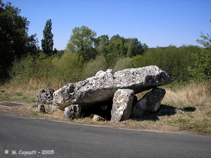
Dolmen de Loubressac submitted by thecaptain on 19th Feb 2006. At the hamlet of Loubressac, the little road curves around the remains of this dolmen.
The capstone, which once would have measured 5 metres by 4 metres, has now broken and collapsed into the chamber.
(View photo, vote or add a comment)
Log Text: Beside the river Goberté to the west of Lussac-les-Chateaux, at the hamlet of Loubressac, the little road curves around the remains of this dolmen. It is now sitting right beside the road at the edge of a pond. The capstone, which once would have measured 5 metres by 4 metres, has now broken and collapsed into the chamber. About 8 or 10 support stones remain, many of which have fallen. The entrance is to the east. Most of the stones are of the local white limestone, with holes and depressions everywhere, but the large support stone at the back of the chamber is a dark granite rock.
Unfortunately there is a telephone inspection cover right beside the dolmen which detracts. While here there was a helicopter flying very low overhead, perhaps checking on the overhead power lines.
Verrières tumulus
Trip No.205 Entry No.14 Date Added: 13th Oct 2020
Site Type: Chambered Cairn
Country: France (Poitou:Vienne (86))
Visited: Saw from a distance on 30th Aug 2005
Log Text: On the village map, about half a kilometre to the southeast of the dolmen, and to the northeast of the road to Lussac-les-Chateaux. I had a walk towards this after getting the van partly sorted, but couldn’t find anything definite. There was however, a mound in a field which has growth on it, which was in the right sort of place. Pity I couldn't get to it and have a proper look, and by now its started to get dark.
Verrières Dolmen
Trip No.205 Entry No.13 Date Added: 13th Oct 2020
Site Type: Burial Chamber or Dolmen
Country: France (Poitou:Vienne (86))
Visited: Yes on 30th Aug 2005. My rating: Condition 2 Ambience 3 Access 4
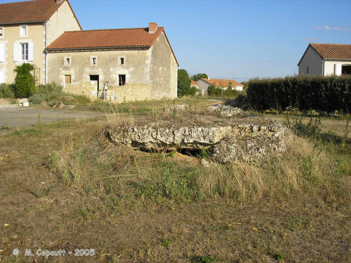
Verrières dolmen submitted by thecaptain on 19th Feb 2006. Just outside the village of Verrières, to the south by the road to Lussac-les-Chateaux, are the remains of this dolmen, which can be found round the back of some houses at the top of the valley.
(View photo, vote or add a comment)
Log Text: Just outside the village of Verrières, to the south by the road to Lussac-les-Chateaux, are the remains of this dolmen, which can be found round the back of some houses at the top of the valley. Its not much more than a large slab of rock sitting on the ground these days, which is the capstone which measures 4 metres by 3 metres, with a few bits of crumbled rock underneath. There are no signs of any obvious support stones.
When I got back to my van after visiting this, the antitheft electronics would not turn off, and so nothing would start. I checked to see if anything obvious was loose, but could find nothing. I checked the other keys and that didn't help. I asked a passing man in a pickup truck if he could help, and he got a bloke from a garage out to help me. He had a look, but couldn't really do anything till tomorrow, when he could get the van to the garage with the necessary electronics gear. We pushed the van down into a little side lane where I could stay overnight, and he promised that he or someone else from the garage who could speak some English would be back in the morning about 8:30. This is just what I always dreaded would happen.
Coeur de Birette
Trip No.205 Entry No.12 Date Added: 13th Oct 2020
Site Type: Polissoir
Country: France (Centre:Indre-et-Loire (37))
Visited: Yes on 30th Aug 2005. My rating: Condition 4 Ambience 3 Access 4

Coeur de Birette submitted by thecaptain on 17th Jun 2008. In the gardens of the Chateau de Grand Pressigny is a polissoir stone called (I believe) the Coeur de Birette, moved to here from the nearby village of Le Petit Pressigny.
(View photo, vote or add a comment)
Log Text: In the gardens of the Chateau de Grand Pressigny are, amongst many other things, a polissoir stone called (I believe) the Coeur de Birette ???.
Grand-Pressigny Musée de la Préhistoire
Trip No.205 Entry No.11 Date Added: 13th Oct 2020
Site Type: Museum
Country: France (Centre:Indre-et-Loire (37))
Visited: Yes on 30th Aug 2005. My rating: Condition 5 Ambience 5 Access 4
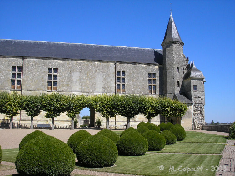
Grand-Pressigny Musée de la Préhistoire submitted by thecaptain on 9th Aug 2008. Fabulous museum of prehistory contained within the remains of the ruined Chateau de Grand Pressigny.
(View photo, vote or add a comment)
Log Text: Museum of prehistory contained within the remains of the ruined Chateau de Grand Pressigny, this is a wonderful place to visit. In a little village on the edge of a plateau, the castle is on a steep sided headland with a huge ditch cut to protect it from the fourth side. This place has been lived in and defended since the year dot. For €4 entry fee, you not only get to visit the castle, but also a fossils exhibition, the prehistory museum, and any other temporary exhibitions that may be held here. The castle is excellent, with curtain walls and towers, dungeons, an excellent gatehouse, a superb keep, a large tower and some magnificent cellars and underground passages crossing from one side to the other, all of which can be visited. In the gardens are, amongst many other things, a polissoir stone (called the Coeur de Birette?) and a bit of an iron age stele.
The chateau is right in the middle of one of the greatest prehistoric regions in the world, where people have lived since before people existed. Cave shelters etc have been identified which go back millions of years. And then there is the silex (flint) for which this region is world renowned. This is a yellowish kind of flint which occurs in huge nodules (livres de beurre), which can be split into many fine and long blades, and which have been worked here for an eternity. Blades up to 30 cm long have been found in the region, and they were traded to places all over western Europe. This is one of the most important places in the western world until the advent of the bronze age. In the prehistory museum, there are some wonderful items, ranging from the ancient paleolithic up to the iron age and then the coming of the Romans. Superb.
Pierre Chaude
Trip No.205 Entry No.10 Date Added: 13th Oct 2020
Site Type: Burial Chamber or Dolmen
Country: France (Centre:Indre-et-Loire (37))
Visited: Yes on 30th Aug 2005. My rating: Condition 4 Ambience 4 Access 5
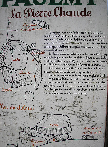
Pierre Chaude submitted by thecaptain on 27th Feb 2006. The informative noticeboard.
(View photo, vote or add a comment)
Log Text: About a kilometre to the east of the village of Neuilly, on the road to Paulmy, can be found this nice dolmen, about 50 metres to the south of the road in a hazlenut grove, and signposted.
The dolmen has a large single capstone which is now broken, sat on top of 6 support stones making a rectangular chamber about 3 metres by 3 metres internal dimensions, and almost 2 metres high at the top. The entrance to the dolmen is through a cut side stone at the eastern side, which has the opening made at the top.
The dolmen was excavated in the 19th century, and several skeletons were found, along with animal bones, polished stones, flint items and pottery. Nearby is the permanent spring of Fonteny, about 200 metres to the south.
La Pierre Fondue
Trip No.205 Entry No.9 Date Added: 13th Oct 2020
Site Type: Burial Chamber or Dolmen
Country: France (Centre:Indre-et-Loire (37))
Visited: Yes on 30th Aug 2005. My rating: Condition 4 Ambience 3 Access 4
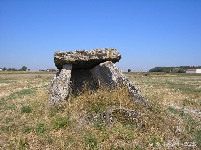
La Pierre Fondue submitted by thecaptain on 24th Feb 2006. The rectangular chamber faces almost due south. There are a few other stones, suggesting either a continuation of the chamber, or perhaps an Angevine portal entrance, but these are fallen and it is not easy to tell exactly what.
(View photo, vote or add a comment)
Log Text: This dolmen can be found about 100 metres up a track behind the hamlet of Bommiers, which is a couple of kilometres to the south of the village of Sainte-Maure-de-Touraine down the N.10. It is about one kilometre to the north of the Pierre Percée. Once you reach the hamlet, it is signposted, and sits in a field which had been harvested when I was here, so was able to visit the dolmen properly.
The dolmen has a single capstone sitting 2 metres high on top of two large side supports and a backstone, and seems to have been moved to the back where it overhangs a lot. The rectangular chamber is about 4 metres by 2.5 metres in size, and faces almost due south. There are a few other stones at the southern end, suggesting either a continuation of the chamber, or perhaps an Angevine portal entrance, but these are fallen and it is not easy to tell what.
Pierre Percée (Draché)
Trip No.205 Entry No.8 Date Added: 13th Oct 2020
Site Type: Standing Stone (Menhir)
Country: France (Centre:Indre-et-Loire (37))
Visited: Yes on 30th Aug 2005. My rating: Condition 5 Ambience 3 Access 4

Pierre Percée (Draché) submitted by thecaptain on 15th Jan 2006. The stone is about 3.5 metres tall, slightly leaning and pointing skywards. About two thirds of the way up is an intriguing hole through the stone, oval in shape, about 25 cm by 20 cm.
(View photo, vote or add a comment)
Log Text: A few kilometres to the south of the village of Sainte-Maure-de-Touraine along the N.10, and this stone is signposted, less than a kilometre to the west along a minor road. The stone has its own little parking area and explanatory signpost, and is set in a nice open grassy area.
The stone is about 3.5 metres tall, slightly leaning and pointing skywards. About two thirds of the way up is an intriguing hole through the stone, oval in shape, about 25 cm by 20 cm, which is perhaps natural.
This menhir has many legends associated with it, and it is said that if children or babies are passed through the hole, they will be cured and immune to various diseases. There is also a legend that the stone was used for sacrifices, and that all of the parts of the sacrificial body must be passed through the hole. It is thought that it may originally have been some form of marker stone for a nearby ancient cemetery, now no longer to be seen.
Pierre Potelée
Trip No.205 Entry No.7 Date Added: 13th Oct 2020
Site Type: Standing Stone (Menhir)
Country: France (Pays de la Loire:Sarthe (72))
Visited: Yes on 29th Aug 2005. My rating: Condition 3 Ambience 3 Access 4

Pierre Potelée submitted by thecaptain on 22nd Feb 2006. This menhir, in the forest to the northeast of La Fleche in Sarthe, is a slab standing on its end, between 2.5 and 3 metres tall, and 2 metres wide, with many holes on one side.
(View photo, vote or add a comment)
Log Text: This stone is about half a kilometre east of the Mere et Fille stones in the forest and is also signposted. I parked in a parking area near to the signpost and walked for several kilometres before returning to my van having found nothing except for more signposts at the other end of the forest track pointing back from where I had come. As I got back to the van, I could see the stone, less than 100 metres from where I had parked, down a different track ! The stone is a slab on its end, between 2.5 and 3 metres tall, and 2 metres wide, with many holes on one side.
Pierres de Mère et Fille
Trip No.205 Entry No.6 Date Added: 13th Oct 2020
Site Type: Standing Stones
Country: France (Pays de la Loire:Sarthe (72))
Visited: Yes on 29th Aug 2005. My rating: Condition 4 Ambience 4 Access 5

Pierres de Mère et Fille submitted by thecaptain on 22nd Feb 2006. The mother and daughter stones can be easily found in the forest to the northeast of La Fleche, and are signposted from nearby.
The mother stone is more than 4 metres tall, and is the western of the pair. The daughter is just over 2 metres tall, and at the east.
(View photo, vote or add a comment)
Log Text: The mother and daughter stones can be easily found in the forest to the northeast of La Fleche, and are signposted from nearby. Both are nicely shaped pointed slabs, and they are about 8 metres from each other in an east west direction. The mother stone is more than 4 metres tall, and is the western of the pair, The daughter is just over 2 metres tall, and at the east. It is stated on a nearby signpost that the stones are thought to represent the sun and moon, although the evidence for this is not stated.
la Pierre Couverte (Parigné)
Trip No.205 Entry No.5 Date Added: 13th Oct 2020
Site Type: Burial Chamber or Dolmen
Country: France (Pays de la Loire:Sarthe (72))
Visited: Yes on 29th Aug 2005. My rating: Condition 3 Ambience 4 Access 4

la Pierre Couverte (Parigné) submitted by thecaptain on 22nd Feb 2006. This dolmen can be fairly easily found at a junction of tracks in the Bois de Bruon, near to Parigné-le-Pôlin, a few kilometres south of Le Mans, and just off the N23 road.
(View photo, vote or add a comment)
Log Text: This dolmen can be fairly easily found at a junction of tracks in the Bois de Bruon, near to Parigné-le-Pôlin, a few kilometres south of Le Mans, and just off the N23 road. The largish capstone, 4 m by 3.5 m, sits on top of 4 collapsed support stones, with another one nearby. its a pleasant little walk along a forest track from where I parked the van.
Menhir dit Pierre Saint-Julien
Trip No.205 Entry No.4 Date Added: 13th Oct 2020
Site Type: Standing Stone (Menhir)
Country: France (Pays de la Loire:Sarthe (72))
Visited: Yes on 29th Aug 2005. My rating: Condition 5 Ambience 3 Access 4

Menhir dit Pierre Saint-Julien submitted by thecaptain on 17th Oct 2005. Pierre Saint Julien menhir stands at the corner of Le Mans Cathedral, just outside the main entrance.
(View photo, vote or add a comment)
Log Text: Pierre Saint Julien is a 3.5 metre tall menhir, stood outside the main entrance to St Julien Cathedral, Le Mans. It is a truly lovely stone, made from a very heavily stratified, and vividly coloured rock. From certain angles, and in the right light, it looks for all the world to be a man dressed in hooded cloak stood outside the entrance of this sacred place. I do not know where the stone originally came from.
La Pierre au Diable
Trip No.205 Entry No.3 Date Added: 13th Oct 2020
Site Type: Standing Stone (Menhir)
Country: France (Pays de la Loire:Mayenne (53))
Visited: Couldn't find on 29th Aug 2005

La Pierre au Diable submitted by davidmorgan on 26th Aug 2010. A four metre tall granite menhir situated among groups of stones which may well be a ruined allée couverte and a dolmen, by the looks of them - difficult to tell since they are covered with undergrowth and trees.
(View photo, vote or add a comment)
Log Text: I couldn't easily find this one, nor anywhere to park to have a proper look. It is not very near to the road, and so I left.
Menhir de la Croix Carrée (Landigou)
Trip No.205 Entry No.2 Date Added: 13th Oct 2020
Site Type: Standing Stone (Menhir)
Country: France (Normandie:Orne (61))
Visited: Yes on 29th Aug 2005. My rating: Condition 3 Ambience 3 Access 5
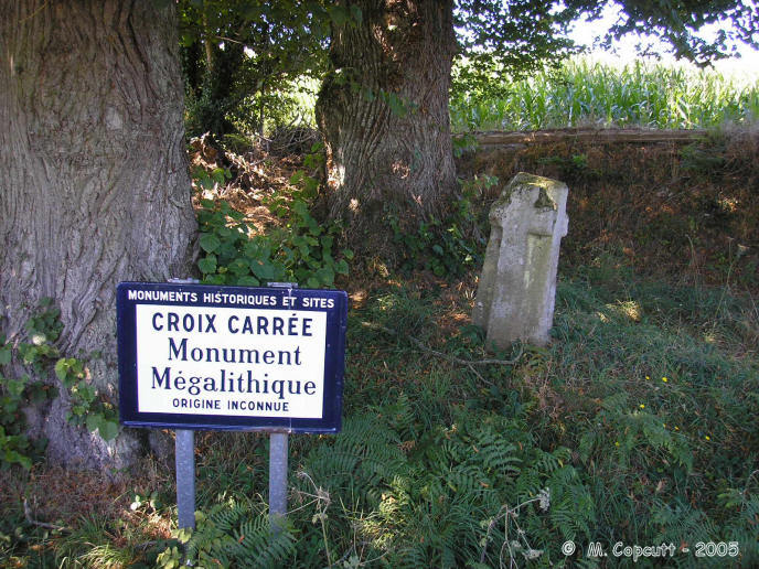
Menhir de la Croix Carrée (Landigou) submitted by thecaptain on 22nd Feb 2006. Menhir de la Croix Carrée (Landigou)
Looking for a menhir marked on my map, I could find nothing, so asked a lady walking her dog, and she directed me to this roadside cross, a couple of kilometres away.
It has a historic monument signpost, which states that it is a megalithic monument of unknown origin.
(View photo, vote or add a comment)
Log Text: Looking for a menhir marked on my map, I could find nothing, so asked a lady walking her dog, and she directed me to this roadside cross. It has a historic monument signpost, which states that it is a megalithic monument of unknown origin. About 1.2 metres tall, it is of square section, with large crosses carved into each face, joining each other around the corners. Perhaps it was once a menhir, perhaps once an iron age stele. Its hard to tell. But it is not the menhir I was looking for !
