Contributory members are able to log private notes and comments about each site
Sites TheCaptain has logged. View this log as a table or view the most recent logs from everyone
Pierre Trouée de l'allée couverte d'Aizier
Trip No.212 Entry No.18 Date Added: 30th Mar 2020
Site Type: Passage Grave
Country: France (Normandie:Eure (27))
Visited: Yes on 27th Dec 2012. My rating: Condition 4 Ambience 4 Access 5
Pierre Trouée de l'allée couverte d'Aizier submitted by theCaptain on 30th Dec 2012. This wonderful holed stone is today found nicely presented just outside the little church of the village of Aizier, right on the banks of the River Seine. The stone is the portholed entry stone from a now destroyed allée couverte, destroyed during the making of a road.
The stone is about 1.7 metres tall and wide, thickness 22 cm, but the important dimension is that of the circular hole, which is diameter 47 cm, and yes, I did manage to crawl through it!
(View photo, vote or add a comment)
Log Text: This wonderful holed stone is today found nicely presented (since 1976) just outside the little church of the village of Aizier, right on the banks of the River Seine not too far upstream from the Tancarville Bridge, a few miles inland from Le Havre.
The stone is the remains of the portholed entry stone from a now destroyed allée couverte, which was destroyed during the making of the road to Bourneville sometime in the 19th century. The stone is about 1.7 metres tall and wide, with thickness 22 cm, but the important dimension is that of the circular hole, which is of diameter 47 cm, and yes, I did manage to crawl through it!
This type of allée couverte was fairly common in this region, and dates to the final neolithic, -3500 BC to -2800 BC.
Le Wuy Menhir
Trip No.212 Entry No.17 Date Added: 30th Mar 2020
Site Type: Standing Stone (Menhir)
Country: France (Normandie:Seine-Maritime (76))
Visited: Yes on 27th Dec 2012. My rating: Condition 3 Ambience 3 Access 5
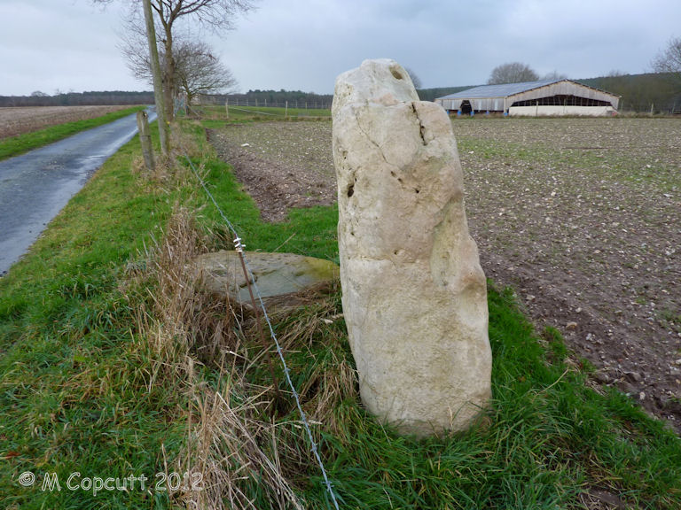
Le Wuy Menhir submitted by theCaptain on 1st Jan 2014. Described as a menhir, this site is more likely the remains of a burial chamber of some sort, which has been largely destroyed by agriculture.
(View photo, vote or add a comment)
Log Text: Described as a menhir, this site is the remains of a burial chamber of some sorts, which has been largely destroyed by agriculture. The remains I found consist of one large standing stone, about 2 m width and just over a metre in height. Its a lovely slab of sarsen like stone, which is all smooth on the southern face, but all lumpy and holed on the northern face, as sarsen often is. Beside this stone is another slab of sarsen flat to the ground.
I am sure this is not a menhir as described, but a remaining slab from a burial chamber of some sort, whether a side slab or end slab is not clear. It is possible that this stone is not in its original position, but has been moved here to help clear the fields for ploughing.
Boswarthen Cross
Date Added: 29th Oct 2019
Site Type: Ancient Cross
Country: England (Cornwall)
Visited: Yes on 19th Dec 2012
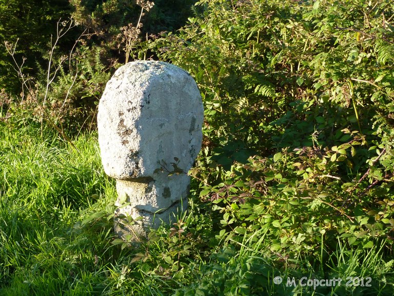
Boswarthen Cross submitted by theCaptain on 19th Dec 2012. A very nice wheel head cross.
The southeastern face has an equal armed cross with widening ends, while the lower part of the cross extends down the shaft.
(View photo, vote or add a comment)
Log Text: None
Zennor Churchyard Crosses
Date Added: 29th Oct 2019
Site Type: Ancient Cross
Country: England (Cornwall)
Visited: Yes on 18th Dec 2012

Zennor Churchyard Crosses submitted by theCaptain on 18th Dec 2012. Not strictly speaking megalithic, but while at Zennor it would be almost criminal not to pay your respects to the Mermaid.
Within St Senara's church, the Mermaid on her small pew is now carefully displayed, with the daylight of a big south window lighting her up. Tremendous.
The church notes suggest it is of medieval origin, more than 600 years old.
(View photo, vote or add a comment)
Log Text: None
Caerloggas Down longstone
Date Added: 29th Oct 2019
Site Type: Modern Stone Circle etc
Country: England (Cornwall)
Visited: Yes on 9th Dec 2012
Caerloggas Down longstone submitted by theCaptain on 9th Dec 2012. A large standing stone, about 6 feet tall surrounded by 5 other stones on a large bump in the ground, with many other stones placed around it, perhaps making twin concentric circles. I assume its a newly erected stone feature.
(View photo, vote or add a comment)
Log Text: None
Caerloggas Down Circle
Date Added: 29th Oct 2019
Site Type: Modern Stone Circle etc
Country: England (Cornwall)
Visited: Yes on 3rd Dec 2012

Caerloggas Down Circle submitted by theCaptain on 3rd Dec 2012. My Dad giving scale to the larger stones
(View photo, vote or add a comment)
Log Text: None
St Eval Church Stones
Date Added: 29th Oct 2019
Site Type: Standing Stones
Country: England (Cornwall)
Visited: Yes on 29th Nov 2012
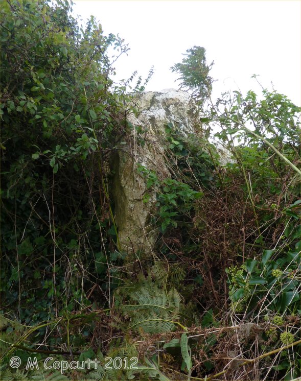
St Eval Church Stones submitted by theCaptain on 29th Nov 2012. St Eval churchyard supposedly has several large standing stones within it and the wall surrounding it, but I was unprepared and didn't know how many or where to look; as a result I only found one of the 3 or more standing stones in its surrounding wall.
(View photo, vote or add a comment)
Log Text: None
St Eval Airport Stone
Date Added: 29th Oct 2019
Site Type: Standing Stone (Menhir)
Country: England (Cornwall)
Visited: Yes on 25th Nov 2012
St Eval Airport Stone submitted by theCaptain on 25th Nov 2012. Not far away is another much smaller block of quartz, whether it is of any significance I don't know.
(View photo, vote or add a comment)
Log Text: None
Brea Hill
Date Added: 29th Oct 2019
Site Type: Round Barrow(s)
Country: England (Cornwall)
Visited: Yes on 23rd Nov 2012
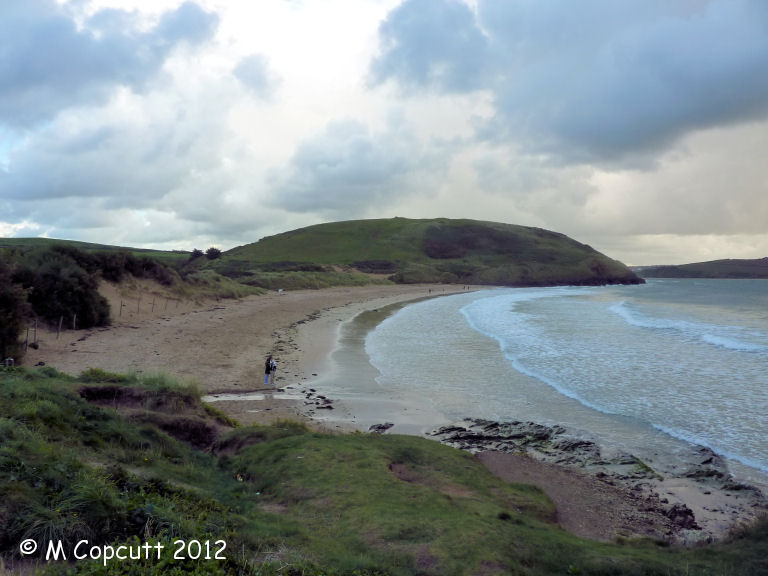
Brea Hill submitted by theCaptain on 23rd Nov 2012. Four, or is it five, round cairns are supremely positioned on the top of the lovely rounded Brea Hill, which sticks out into the beautiful Camel Estuary to the south of Daymer Bay
(View photo, vote or add a comment)
Log Text: None
Redcliff Castle
Date Added: 29th Oct 2019
Site Type: Promontory Fort / Cliff Castle
Country: England (Cornwall)
Visited: Yes on 12th Nov 2012

Redcliff Castle submitted by theCaptain on 12th Nov 2012. looking south along the top of the inland (or is it central) rampart.
(View photo, vote or add a comment)
Log Text: None
Penwine Cross
Date Added: 29th Oct 2019
Site Type: Ancient Cross
Country: England (Cornwall)
Visited: Yes on 7th Nov 2012

Penwine Cross submitted by theCaptain on 7th Nov 2012. The front face of tthis re-erected cross head has an equal armed cross engraved onto it.
(View photo, vote or add a comment)
Log Text: None
Roche Rock
Date Added: 29th Oct 2019
Site Type: Rock Outcrop
Country: England (Cornwall)
Visited: Yes on 6th Nov 2012

Roche Rock submitted by theCaptain on 6th Nov 2012. Passing on the way to visit the Eden Project, the rock and chapel were lit up by the most amazing silvery sunlight against a dark grey sky.
By the time I had stopped the car and got out, it had gone. I waited a while, and took a couple of pictures, some of which have it fairly well lit, but not so good as the initial view!
(View photo, vote or add a comment)
Log Text: None
Longstone (St Mabyn)
Date Added: 29th Oct 2019
Site Type: Standing Stone (Menhir)
Country: England (Cornwall)
Visited: Yes on 6th Nov 2012

Longstone (St Mabyn) submitted by theCaptain on 6th Nov 2012. The stone stands just over a metre tall and is fairly flat, and nicely presented.
(View photo, vote or add a comment)
Log Text: None
St George's Well (Padstow)
Date Added: 29th Oct 2019
Site Type: Holy Well or Sacred Spring
Country: England (Cornwall)
Visited: Yes on 5th Nov 2012

St George's Well (Padstow) submitted by theCaptain on 5th Nov 2012. St George's Cove is a sandy inlet on the western side of the Camel Estuary, about a kilometre or so north of Padstow.
A little stream runs down from the fields here onto the beach at the cove, and sometimes makes a pool or sometimes just dries up in the sands without directly reaching the sea.
(View photo, vote or add a comment)
Log Text: None
Montchauvet Alignements
Date Added: 29th Oct 2019
Site Type: Standing Stones
Country: France (Normandie:Calvados (14))
Visited: Yes on 29th Oct 2012
Montchauvet alignements submitted by theCaptain on 29th Oct 2012. I found nine large stones in the field, mostly flat to the ground, but one or two upright.
(View photo, vote or add a comment)
Log Text: None
Leskernick cairn
Date Added: 29th Oct 2019
Site Type: Cairn
Country: England (Cornwall)
Visited: Yes on 27th Oct 2012
Leskernick cairn submitted by theCaptain on 27th Oct 2012. Looking westwards towards the cairn from the tin worked stream.
A couple of stones from the stone row can be seen
(View photo, vote or add a comment)
Log Text: None
Roche Buquet
Date Added: 12th Oct 2012
Site Type: Standing Stone (Menhir)
Country: France (Bretagne:Ille-et-Vilaine (35))
Visited: Yes on 11th Oct 2012

Roche Buquet submitted by thereddragon on 9th Oct 2012. Site in Bretagne:Ille-et-Vilaine (35) France
(View photo, vote or add a comment)
Log Text: None
Menhir de la Pierre Fichée (La Pinelais)
Date Added: 12th Oct 2012
Site Type: Standing Stone (Menhir)
Country: France (Bretagne:Ille-et-Vilaine (35))
Visited: Yes on 11th Oct 2012. My rating: Condition 3 Ambience 3 Access 4

Menhir de la Pierre Fichée (La Pinelais) submitted by thereddragon on 9th Oct 2012. Pierre Fichée (La Pinelais)
(View photo, vote or add a comment)
Log Text: A bit like busses, this menhir has been ignored by the megalithic portal's stonehunters for many years, and then 2 come along in 2 days!
Mont St Michel
Trip No.212 Entry No.13 Date Added: 13th Jun 2020
Site Type: Ancient Village or Settlement
Country: France (Normandie:Manche (50))
Visited: Yes on 11th Oct 2012. My rating: Condition 5 Ambience 4 Access 4
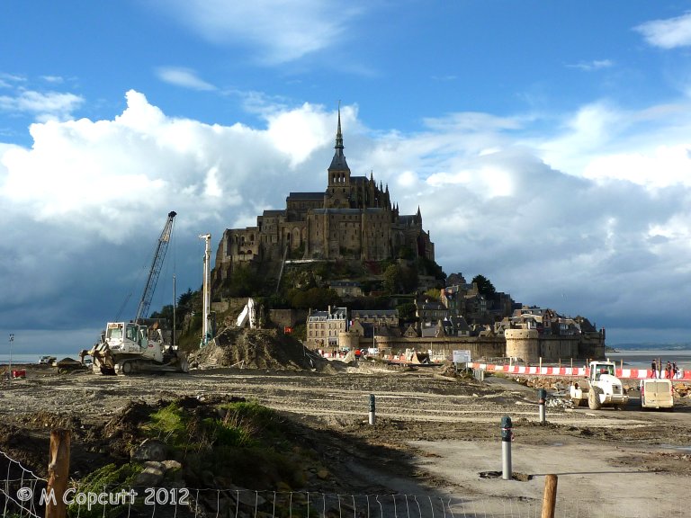
Mont St Michel submitted by theCaptain on 4th Jan 2013. They are trying to cut off the Mont again, to get the sea to surround it once more, and this involves removing the old causeway which prevented the tide clearing the silts etc, and just have a bridge going out to the Mont. This and alterations to the river should then mean the silts get washed away, and the sea once more claims the Mont at each high tide.
(View photo, vote or add a comment)
Log Text: Getting a late lunch at Plein Fougeres, it is now much too late to go to Fougeres and have a proper look round, so we decide to go to Mont St Michel for a quick look around. Shouldn't be too busy at this time of year. It has all changed since either myself or Dad was last there, and you now have to park miles away, at what is becoming a sort of holiday village resort. Many huge car parks, some hotels and restaurants etc, and a 40 min walk to the Mont, but free shuttle busses are provided. At this point I was ready to give up and drive away, but Dad still wanted to persevere, so we got the shuttle bus 10 mins out to the Mont.
Theres a hell of a lot of work going on here, both to the walls and the surroundings. Turns out they are trying to cut off the Mont again, to get the sea to surround it once more, and this involves removing the old causeway etc, and just have a sort of bridge going out to the Mont. This and alterations to the river should then mean the silts get washed away, and the sea once more claims the Mont at each high tide. I read at the new controlling dam on the river that the land has risen 4.9 metres since the 1960s. Much of these new grassy marshes is being dug up and pushed into the river, hopefully to get washed away.
The place is not too crowded, although many Japanese here, so we walk up to the abbey along the main street, no time to do the tour. Walk down around the outer walls, watching the tide coming in, and theres a group of people out walking over the sands and mud with the water coming in. Just as we leave the Mont, the sun starts to come out, making a few pictures much better.
Cup of tea, then on to Sara's, much later than we ought to be, but this time its not all my doing! Must visit here properly sometime, October Thursday mornings might be OK, but need the whole day.
St Breock Beacon Kistvaen
Date Added: 5th Nov 2019
Site Type: Burial Chamber or Dolmen
Country: England (Cornwall)
Visited: Yes on 28th Sep 2012. My rating: Condition 2 Ambience 2 Access 4
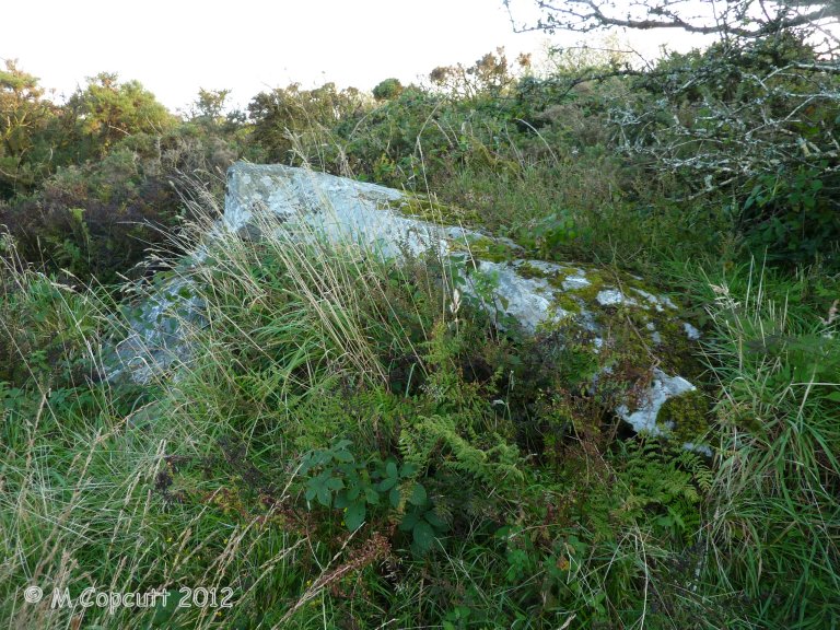
St Breock Beacon Kistvaen submitted by theCaptain on 17th Dec 2012. Recently rediscovered underneath a heavily overgrown region of scrub, just to the southwest of Men Gurta. It basically consists of two large stone slabs, one leaning on the other.
(View photo, vote or add a comment)
Log Text: Recently rediscovered underneath a heavily overgrown region of scrub, just to the southwest of Men Gurta, this monument was first recorded by William Borlase in his 1872 work Naenia Cornubiae.
It basically consists of two large stone slabs, one leaning on the other. I found it by walking in a southwesterly direction from Men Gurta across scrubland and then down a track towards the trigpoint. Just after crossing a farmtrack, there is an area of very overgrown gorse bushes, which seem to nowadays be used for dumping and tipping waste and junk. From on top of one of the piles of rubble, I had a good look around, and saw the large stones not far away, but impossible to reach from my position. Having another attempt from a more easterly position, I managed to get through the waist high gorse and brambles, while at times I found myself in water almost up to my knees! The things we stonehunters put ourselves through.
When I eventually got to the stones, I couldn't see much, as the surrounding area was so waterlogged and they are so overgrown, but it is clear they are a megalithic construction. With this now back on the megalithic map, I am sure others will be able to get better pictures and descriptions of this during better conditions, and before it becomes totally covered in the rubble and junk tipped up here.
