Contributory members are able to log private notes and comments about each site
Sites bat400 has logged. View this log as a table or view the most recent logs from everyone
Chaco Culture NHP
Date Added: 12th Dec 2012
Site Type: Ancient Village or Settlement
Country: United States (The Southwest)
Visited: Yes on 25th Apr 2012. My rating: Condition 3 Ambience 5 Access 4

Chaco Culture NHP - Pueblo Bonito submitted by bat400 on 25th May 2012. Pueblo Bonito Great House, taken from the cliff edge directly north of the site. Photo by bat400, April 2012.
(View photo, vote or add a comment)
Log Text: The park is must see for anyone visiting northwest New Mexico. However, the park is in a remote area, with minimal services. (In my opinion, this is part of the experiance.)
Be sure to review the park website to properly prepare for your trip. Camping at the park and extending your visit for several days would have many rewards, but all the major sites along the paved driving loop can be visited in one long day. If you are at all fit, take one of the "back country" trails to visit one or more sites on the mesa tops surrounding the canyon and "Downtown Chaco".
Park ranger tours are available at the main sites several times a day during high season, see the website for the National Park. Inexpensive guide books are often available as you enter specific sites, or from the Visitor's Center. Wheel chair access is possible for portions of the walking trail at Pueblo Bonito, but even there the path is sand or gravel, not paved. Large chair tires or an assistant would be necessary.
Note: A sturdy passenger vehicle is adequate to cross aproximately 13 miles of unpaved, washboard roads to reach the park itself. No not use a vehicle with "low profile" tires, and call for road conditions during the winter or following any periods of rain. Locals take the dirt road at speeds that you would not think possible, and actually reaching speeds of 45-55 mph will reduce the severe impacts as your car's shock absorbers dampen out the input frequency of the roadbed. (Try this, but remember that you MUST slow on curves, when coming on rises, or whenever visiblity is degraded. Otherwise you will slide off the road or strike other vehicles or livestock.)
Tippett Mound
Date Added: 12th Dec 2012
Site Type: Artificial Mound
Country: United States (Great Lakes Midwest)
Visited: Yes on 25th Jun 2011. My rating: Condition 4 Ambience 4 Access 2
Log Text: I hiked to this mound from the north entrance of the Taft Reserve. There is a pictorial trail map on a display in a parking area that clearly identifies the mound. The most direct routes appears to be on a trail that starts as a rough, grassy lane from the north east corner of the property, along a fence line, but through woods. Basically stay to the left at all junctions until you find a post marked "9", then turn right. You will very quickly leave the woods and enter a meadow, only some of which is kept mowed. The mound is immediately obvious and straight ahead. You can approach the tree covered mound in order to see the contour clearly, but in late June, this was by make a path through chest high grass, wildflowers and bramble.
Grand Village of Natchez Indians
Date Added: 29th Aug 2012
Site Type: Ancient Village or Settlement
Country: United States (The South)
Visited: Yes on 1st Oct 2011. My rating: Condition 2 Ambience 3 Access 4

Grand Village of Natchez Indians submitted by bat400 on 30th Aug 2012. Reconstructions of Natchez house and granary from the time of first contact with the Spanish and French (16th-17th C).
Photo by bat400, Oct 2011.
(View photo, vote or add a comment)
Log Text: Interesting site for a short visit. The mounds are reconstructions based on the footprints discovered during excavations. And the layout tells you something about the size of the village.
The small museum is worth a visit, as is a trip to the huge Emerald Mound, outside of Natchez. A comparison of the collossal Emerald Mound ceremonial site to this modest one, seemed to me to tell a lot about the devastation caused by the introduction of "Old World" disease to the Americas.
Admision to the site is free but a donation is suggested.
Mesa Verde - Square Tower House
Date Added: 14th Jun 2012
Site Type: Ancient Village or Settlement
Country: United States (The Southwest)
Visited: Yes on 27th Apr 2012. My rating: Condition 3 Ambience 5 Access 4

Mesa Verde - Square Tower House submitted by DrewParsons on 18th Oct 2008. Detail of the Square Tower House site at Mesa Verde
(View photo, vote or add a comment)
Log Text: Observed from overlook. Short trail to the overlook from the road is not paved, fairly level.
Mesa Verde - Sun Temple
Date Added: 5th Jun 2012
Site Type: Ancient Temple
Country: United States (The Southwest)
Visited: Yes on 28th Apr 2012. My rating: Condition 3 Ambience 4 Access 5

Mesa Verde - Sun Temple submitted by bat400 on 2nd Jun 2012. The eastern end of the Sun Temple. Photo taken over the separate associated round structure.
Photo by bat400, April 2012.
(View photo, vote or add a comment)
Log Text: A large somewhat mysterious pueblo site on the lip on the canyon overlooking the Cliff Palace and about a dozen other sites. What you see is a restoration, although when the mound of collected dust, dirt, and fallen masonary was removed and examined, it was obvious that the building never had a roof. In that and other features, tt's quite different architecturally from any other sites at Mesa Verde or other places in the area.
You'll see photos showing visitors walking inside the massive outer walls, using ladders to climb in and out of the site, but this doesn't seem to be allowed any more.
Mesa Verde - Cliff Palace
Date Added: 5th Jun 2012
Site Type: Ancient Village or Settlement
Country: United States (The Southwest)
Visited: Yes on 28th Apr 2012. My rating: Condition 3 Ambience 5 Access 3

Mesa Verde - Cliff Palace submitted by DrewParsons on 18th Oct 2008. Mesa Verde - The Cliff Palace. September 2005
(View photo, vote or add a comment)
Log Text: Cliff Palace is the largest cliff dwelling in the park. It faces west and gets maximum light in the late afternoon. You are allowed to walk along the restored retaining wall (now a walkway) and around several kivas in front of the square tower. We were invited to look up into the Sqare Tower to see the plastered wall mural on the thrid floor, which I was itching to do since I knew it was up there. This access is only as part of a tour, although you can look from two different overlooks to your heart's content, sans guidance.
There are simple tour guides available, and a great many web and other media resources you can absorb ahead on your visit. The ranger will give you a substantial amount of information on the current archaeological thought about why the cliff dwellings were built and later abandoned, as well as the history of excavation and resoration. How well they do this probably varies, although I was very satisfied with my tour's leader.
This is one of the most visited on Ranger Led tours. (These tours are for a very small additional fee over the park entrance fee, but they limit the number of people who can visit the site.) The rangers will warn you (for all tours) about the number of steps, ladders, and the impact of altitude. If you are used to hiking and are moderately healthy, this tour is not difficult, even accounting for the altitude.
The tour is advertised as 1 hour long, although this stretches in the shoulder season when there are fewer tours scheduled farther apart.
Mesa Verde
Date Added: 5th Jun 2012
Site Type: Ancient Village or Settlement
Country: United States (The Southwest)
Visited: Yes on 27th Apr 2012. My rating: Condition 3 Ambience 5 Access 3

Mesa Verde - Cliff Palace submitted by DrewParsons on 18th Oct 2008. Mesa Verde - The Cliff Palace. September 2005
(View photo, vote or add a comment)
Log Text: Once you are in the Park there are many ancient sites you can visit on your own and without additional fees. Everyone wants to see the spectacular cliff dwellings, but don't neglect the many mesa top dwelling and farming sites that are actually much more typical of occupation at Mesa Verde.
The drive from the main entrance to the Visitor Center, muesums, and the nearest sites takes about 30-45 minutes, the distance to nearby towns and lodging is another 30 minutes minimum. So if the campground or lodge are open, it may be worth it to stay there.
Major forest fires have destroyed substantial portions of the mesa top trees, leaving a bare and not particularly pleasant landscape in a majority of the park, with living plants limited to scrubs and ground cover. However, there are still terrific views down into the canyons and across the horizon to the San Jaun Mountains, Shiprock, and other landmarks.
Mesa Verde - Spruce Tree House
Date Added: 5th Jun 2012
Site Type: Ancient Village or Settlement
Country: United States
Visited: Yes on 26th Apr 2012. My rating: Condition 3 Ambience 4 Access 3

Mesa Verde - Spruce Tree House submitted by DrewParsons on 19th Oct 2008. Site in United States: Mesa Verde - Spruce Tree House photographed in September 2005
(View photo, vote or add a comment)
Log Text: Spruce Tree House is an especially interesting cliff dwelling to visit because in the summer time it is open all day and you can spend as much time as you like there. You can basically walk along the front of the dwelling, and at specific points, between some of the buildings. There is more light shining on this dwelling in the afternoon.
If you get to talking with the rangers they are happy to point out features that may be more difficult to see - like the hand print an ancient plasterer left in contrasting color on a house wall, or the incised bird footprints (turkey tracks) someone made in the floor of one of the rooms.
I rated this "A longer walk" simply because the paved path is quite steep in places, even though the total elevation change is only about 100 feet. There are no ladders or steps. However, like all Mesa Verde sites, the elevation change will be very noticeable to someone who is from lower elevations or is unused to substantial exercise. However, you can also see much of the site from an overlook that is directly behind the Chapin Mesa Museum. That overlook view point is a short walk on a paved footpath and definitely wheel chair accessible.
Chaco Culture NHP - Pueblo Bonito
Date Added: 1st Jun 2012
Site Type: Ancient Village or Settlement
Country: United States (The Southwest)
Visited: Yes on 25th Apr 2012. My rating: Condition 3 Ambience 5 Access 4

Chaco Culture NHP - Pueblo Bonito submitted by bat400 on 25th May 2012. Pueblo Bonito Great House, taken from the cliff edge directly north of the site. Photo by bat400, April 2012.
(View photo, vote or add a comment)
Log Text: An amazing site, the absolute must-see for anyone visiting the park. In the morning I was on a hike that took me to the cliff top above Pueblo Bonita for a striking "aerial" view. By the afternoon, the site was overcast. I think the structure would be particularly beautiful early or late in the day with full sun creating shadows as you walk through the vacant rooms.
The trail through the site limits you by which rooms you can enter, but you can completely circuit the outer wall of the pueblo and there is access to most of the plazas and many rooms in the eastern portion. You can linger as long as you like during daylight hours. Various masonary techniques and architectural styles can be seen in the complex.
Park ranger tours are available several times a day during high season, see the website for the National Park. An inexpensive guide is also available as you enter the site, or from the Visitor's Center. Wheel chair access is possible for a portion of the site's walking trail, but the path is sand or gravel, not paved. Large chair tires or an assistant would be necessary.
Chaco Culture NHP - Pueblo Alto
Date Added: 1st Jun 2012
Site Type: Ancient Village or Settlement
Country: United States (The Southwest)
Visited: Yes on 26th Apr 2012. My rating: Condition 2 Ambience 4 Access 2

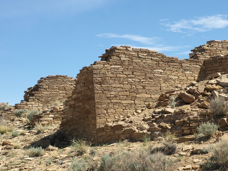
Chaco Culture NHP - Pueblo Alto submitted by bat400 on 27th May 2012. One of the larger standing walls of the ruin. Most of the structure has been backfilled for its protection.
Photo by bat400.
(View photo, vote or add a comment)
Log Text: I decided to hike directly to the site and back using the park service trail (which also includes a loop on the mesa top with an overlook of the Chetro Ketl site and a view of the Jackson Staircase, an ancient stairway carved into the cliff.)
Pueblo Alto has had minimal excavations. The southwestern portion has the most exposed and intact portions, and the walls there show broad stone blocks separated by thin bands of tabular stone. But, the entire site can be circled, seeing the layout of the rooms and central plaza. If you feel the need to cross the mound of the rooms to the central plaza (not expressly forbidden, but definitely discouraged) please follow a path that has already been made, and don't step on the structures stones.
From the northern room blocks there are signs identifying Huerfano Mountain on the horizon in the direction of a northern Chaco road that led toward Chacoan communities on the San Jaun River.
The most difficult part of this hike (which took two and a half hours to walk to Pueblo Alta, New Alta and back, with stops for photography and viewing Pueblo Bonito from the cliff edge) was getting up on the mesa from the trailhead (and back down). From the trailhead parking area, you walk on a flat track to Kin Kletso. Then directly behind that site you go straight up the cliff, following a marked but tightly switch backed climb over boulders for about 40 feet high. The last bit of this is unsupported on the west side (sheer drop off,) but you'd really have to be flailing around to make it dangerous. At this point you can see where the trail goes up a crack behind the cliff face. Although this too is over boulders, you are in the shade and have the cliff walls on both sides until you emerge at the top, 140 feet off the canyon floor.
The trail goes over bare rock along the edge of the cliff (following small cairns) and then turns north toward the two mesa top Great Houses. You have to climb up one more terrace (again, over boulders - tough on my short legs) and then the path is very obvious, through the sage brush and clumps of wildflowers (blooming in April). The total elevation change from the canyon floor appears to be about 250 feet, but if you are a flat lander, it seems like more than that.
Follow the park guidelines and take plenty of water (even if you end up bringing some of it back with you), where a hat and decent walking shoes/boots. I would say a long sleeve cotton shirt is a must, and I also took a jacket (just in case.) The temperature was actually fairly cool, but the only shade was when you are going up the crack in the cliff, so it felt quite warm.
The park service makes this portion of the trail as easy as possible with markers at turns and occasionally placing placards by objects of interest. These include exposed fossils, two bedrock grinding bowls, actual stairs created by the Chacoans, and a portion of ancient roadway showing the stone cerb. I also saw a fairly obvious spiral petroglyph on a boulder.
Chaco Culture NHP - Hungo Pavi
Date Added: 29th May 2012
Site Type: Ancient Village or Settlement
Country: United States (The Southwest)
Visited: Yes on 25th Apr 2012. My rating: Condition 2 Ambience 4 Access 4

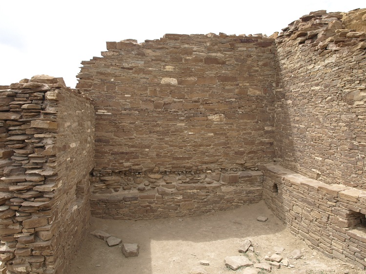
Chaco Culture NHP - Hungo Pavi submitted by bat400 on 27th May 2012. The interior of a room in the northeast corner of the complex. The ground floor room is almost completely filled with shifted sand and earth. The second floor room above it is marked by the line of secondary beams below it.
Photo by bat400, April 2012.
(View photo, vote or add a comment)
Log Text: None
Chaco Culture NHP - Kin Kletso
Date Added: 29th May 2012
Site Type: Ancient Village or Settlement
Country: United States (The Southwest)
Visited: Yes on 26th Apr 2012. My rating: Condition 2 Ambience 5 Access 3

Chaco Culture NHP - Kin Kletso submitted by bat400 on 1st Jun 2012. View from a resting place halfway up the cliff just north of the site.
Photo by bat400, April 2012.
(View photo, vote or add a comment)
Log Text: None
Chaco Culture NHP - Chetro Ketl
Date Added: 29th May 2012
Site Type: Ancient Village or Settlement
Country: United States (The Southwest)
Visited: Yes on 26th Apr 2012. My rating: Condition 3 Ambience 5 Access 4

Chaco Culture NHP - Chetro Ketl submitted by bat400 on 27th May 2012. The Great Kiva of Chetro Ketl. Aside from the missing roof and plaster, this is possible the finest preserved Great Kiva in the southwest.
Photo by bat400, April 2012.
(View photo, vote or add a comment)
Log Text: None
Chaco Culture NHP - Casa Rinconada
Date Added: 29th May 2012
Site Type: Ancient Temple
Country: United States (The Southwest)
Visited: Yes on 26th Apr 2012. My rating: Condition 4 Ambience 5 Access 4

Chaco Culture NHP - Casa Rinconada submitted by bat400 on 27th May 2012. In this view you can see the stone bench around the base of the interior wall, the many niches, and the room structure outside the kiva on the north side of the building.
Photo by bat400, April 2012.
(View photo, vote or add a comment)
Log Text: This Great Kiva is isolated from the Great Houses themselves and sits on a natural rise across Chaco Wash from Pueblo del Arroyo, Pueblo Bonito, and Chetro Ketl. All of these Great Houses are clearly visible from the ridge where Casa Rinconada was built. You can walk completely around the building and into a portion of the northern antechamber.
You walk up a clearly marked trail from a parking area/trail head. Several small pueblo communittees lie to the north and east of the great kiva. You can visit them as well.
Chaco Culture NHP - Una Vida
Date Added: 29th May 2012
Site Type: Ancient Village or Settlement
Country: United States (The Southwest)
Visited: Yes on 25th Apr 2012. My rating: Condition 2 Ambience 5 Access 3

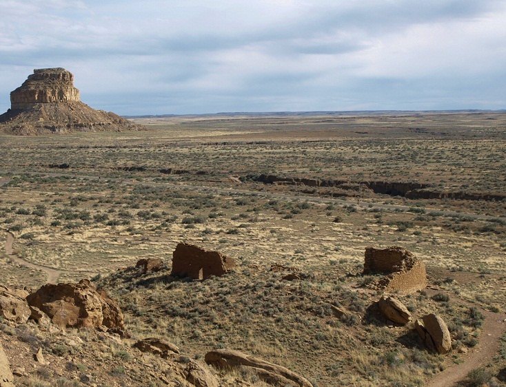
Chaco Culture NHP - Una Vida submitted by bat400 on 27th May 2012. A view of the Great House ruin from the cliffside to the north east. Fajada Butte is in the distance.
Photo by bat400.
(View photo, vote or add a comment)
Log Text: Atmospheric, and has great views of Fajada Butte (somewhat marred by a view of the rear of the visitor's center). I was there as the sun was starting to set. The site is actually built on a fairly obvious slope above the canyon floor. Since it is mostly in an unexcavated or backfilled state, a trail guide is very helpful.
The petroglyph panel is further up the slop into the lower margin of the cliffs. The view from that location gives you a better appreciation for the Great House layout.
Chaco Culture NHP - New Alto
Date Added: 28th May 2012
Site Type: Ancient Village or Settlement
Country: United States (The Southwest)
Visited: Yes on 25th Apr 2012. My rating: Condition 2 Ambience 4 Access 2

Chaco Culture NHP - New Alto submitted by bat400 on 27th May 2012. New Alto.
Photo by bat400, April 2012.
(View photo, vote or add a comment)
Log Text: A large raven flew from Pueblo Alto, left, to perch on the walls of New Alto as I approached. (Dexter to my path ... had I been an ancient Roman, I might have turned around and went away...)
A little eerie, as this ruin stands on the edge of a flat sagebrush plain north of Chaco Canyon. Only a portion of the structure has walls standing above the mound that encases the majority of it. You are actually seeing the walls of the second floor of the building.
See my site log for Pueblo Alto (http://www.megalithic.co.uk/article.php?sid=15539) for what the trail was like to get up to New Alto from the canyon floor.
Aztec Ruins National Monument
Date Added: 25th May 2012
Site Type: Ancient Village or Settlement
Country: United States (The Southwest)
Visited: Yes on 27th Apr 2012. My rating: Condition 3 Ambience 4 Access 4

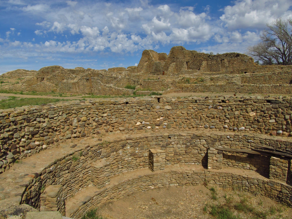
Aztec Ruins National Monument submitted by Creative Commons on 22nd Dec 2018. Aztec Ruins National Monument is located in Northern New Mexico. It was home to the Ancestral Puebloans, who built and lived in the great houses here beginning in the mid 11th century until the late 13th century. The West Ruin, also called the Aztec West Great House, was three stories tall and contained over 500 rooms. Image copyright: Jasperdo, hosted on Flickr and displayed under the terms of their API.
(View photo, vote or add a comment)
Log Text: None
Anasazi Indian State Park
Date Added: 25th May 2012
Site Type: Ancient Village or Settlement
Country: United States (The Southwest)
Visited: Yes on 1st May 2012. My rating: Condition 2 Ambience 3 Access 4

Anasazi Indian State Park submitted by TheCaptain on 5th Dec 2010. Pit house structure at Boulder Anasazi village.
Picture from a 1990 trip, and now faded and deteriorated.
(View photo, vote or add a comment)
Log Text: None
Sounion Temple of Poseidon
Date Added: 7th Apr 2012
Site Type: Ancient Temple
Country: Greece (Central Greece)
Visited: Yes
Sounion Temple of Poseidon submitted by AlexHunger on 23rd Aug 2006. 5th century BCE Temple of Poseidon on the the southernmost point of Attica surounded by the Aegean on 3 sides.
(View photo, vote or add a comment)
Log Text: None
Epidaurus Temple of Asklepios
Date Added: 7th Apr 2012
Site Type: Ancient Temple
Country: Greece (Peloponnese Peninsula)
Visited: Yes on 1st May 2011. My rating: Condition 2 Ambience 4 Access 4

Epidaurus Temple of Asklepios submitted by Antonios on 1st Jul 2008. Site in Peloponnese Peninsula Greece: Τholos of Asklepios. Only the underground section is intact, with a diameter of 21.82 metres. Built with big square stones. Possibly used for thechthonic worship of the god associated with the holy serpents of medicine.
(View photo, vote or add a comment)
Log Text: The temple is currently under a partial reconstruction. Like the work at the Acropolis in Athens. The new stone has been chosen so that it is obvious what portion is "new".
