Contributory members are able to log private notes and comments about each site
Sites theCAptain has logged. View this log as a table or view the most recent logs from everyone
Grotte des Rideaux
Trip No.205 Entry No.44 Date Added: 21st Oct 2020
Site Type: Cave or Rock Shelter
Country: France (Midi:Haute-Garonne (31))
Visited: Yes on 5th Sep 2005. My rating: Ambience 5 Access 3
Grotte des Rideaux submitted by TheCaptain on 28th Nov 2010. In the gorges of the river Save, just below the village of Lespugue, can be found many caves and shelters which have yielded ancient remains of habitation from up to 30,000 years ago.
Below the Chateau de Lespugue, but very difficult to get to due to the steep sides of the gorge and all the undergrowth is the Grotte des Rideaux within which was found the Venus de Lespugue ivory figurine.
(View photo, vote or add a comment)
Log Text: In the gorges of the river Save, just below the village of Lespugue, can be found many caves and shelters which have yielded ancient remains of habitation from up to 30,000 years ago. Below the Chateau de Lespugue, but very difficult to get to due to the steep sides of the gorge and all the undergrowth is the Grotte de Rideaux (not far from the place where there is a rock in the middle of the road) within which was found the Venus de Lespugue figurine.
Grotte du Pape
Date Added: 18th Sep 2010
Site Type: Cave or Rock Shelter
Country: France (Aquitaine:Landes (40))
Visited: Yes on 1st Apr 2007
Grotte du Pape submitted by thecaptain on 1st Apr 2007. The "Dame de Brassempouy".
A female head carved from ivory, found in the Grotte du Pape near to the village of Brassempouy in 1894.
The figure is only 3.6 cm big, and is thought to be the oldest representation of a human face, dating to almost 30,000 years ago.
The figure normally resides in the St Germain-en-Laye prehistory museum, but is seen here in an exhibition of Women in Art throughout history, which I saw at the Bougon Tumuli in 2005.
(View photo, vote or add a comment)
Log Text: None
Grotte-aux-Fées (Tréal)
Trip No.203 Entry No.13 Date Added: 30th Mar 2020
Site Type: Burial Chamber or Dolmen
Country: France (Bretagne:Ille-et-Vilaine (35))
Visited: Yes on 13th May 2005. My rating: Condition 4 Ambience 4 Access 4

Grotte-aux-Fées (Tréal) submitted by greywether on 27th Jun 2005. From NW. June 1994 - shortly after it was restored.
(View photo, vote or add a comment)
Log Text: A fine lateral entry allée couverte at the top of a hill just to the northwest of the Saint Just megaliths and signposted from there. The main chamber is about 13 metres long 1.2 m wide and oriented 102°. The entrance is on the south side with a couple of laterally set portal stones near the east end. There are 8 capstones in place and all the stones get larger to the west end. The stones are made from the strange lumpy local Schist.
Grottes d'Arcy-sur-Cure
Trip No.204 Entry No.220 Date Added: 4th Sep 2020
Site Type: Cave or Rock Shelter
Country: France (Bourgogne:Yonne (89))
Visited: Saw from a distance on 4th Aug 2005

Grottes d'Arcy-sur-Cure submitted by aolson on 24th Jul 2020. The entrance to the Great Cave, the only one open to the public.
(View photo, vote or add a comment)
Log Text: I drove past these caves, without realising what significance they have. If I had realised, I would have visited.
Grottes et abris préhistoriques de la vallée de la Save
Trip No.200 Entry No.55 Date Added: 17th Jun 2020
Site Type: Cave or Rock Shelter
Country: France (Midi:Haute-Garonne (31))
Visited: Yes on 22nd Jul 2000. My rating: Ambience 4 Access 5
Grottes et abris préhistoriques de la vallée de la Save submitted by TheCaptain on 28th Nov 2010. In the gorges of the river Save, just below the village of Lespugue, can be found many caves and shelters which have yielded ancient remains of habitation from up to 30,000 years ago.
(View photo, vote or add a comment)
Log Text: Drive west from Toulouse to explore Gascony. Montmaurin, Mielan, Mirande, Condom, St Puy, Fleurance, Mauvezin, Cologne. Fields of sunflowers, beautiful. An intriguing little road through a gorge with lots of cliff shelters and cave which contained ancient remains.
Grottes et abris préhistoriques de la vallée de la Save
Date Added: 21st Oct 2020
Site Type: Cave or Rock Shelter
Country: France (Midi:Haute-Garonne (31))
Visited: Yes on 5th Sep 2005. My rating: Condition 2 Ambience 5 Access 5
Grottes et abris préhistoriques de la vallée de la Save submitted by TheCaptain on 28th Nov 2010. In the gorges of the river Save, just below the village of Lespugue, can be found many caves and shelters which have yielded ancient remains of habitation from up to 30,000 years ago.
(View photo, vote or add a comment)
Log Text: In the gorges of the river Save, just below the village of Lespugue, can be found many caves and shelters which have yielded ancient remains of habitation from up to 30,000 years ago. Below the Chateau de Lespugue, but very difficult to get to due to the steep sides of the gorge and all the undergrowth is the Grotte de Rideaux (not far from the place where there is a rock in the middle of the road) within which was found the Venus de Lespugue figurine. Some of the many other Abris and caves are easily visited, being right by the roadside. This is a fascinating place, and amazing to think about all its long history. Well worth a look.
Grouanec stèle
Trip No.203 Entry No.521 Date Added: 28th May 2020
Site Type: Standing Stone (Menhir)
Country: France (Bretagne:Finistère (29))
Visited: Yes on 21st Jun 2005. My rating: Condition 4 Ambience 3 Access 5
Grouanec stèle submitted by theCaptain on 20th Feb 2012. This is a fantastic iron age stèle by the D.32 roadside just to the east of the village of St Groanec, which has been christainised and turned into a roadside cross.
(View photo, vote or add a comment)
Log Text: This is a fantastic iron age stèle by the D.32 roadside just to the east of the village of St Groanec, which has been christainised and turned into a roadside cross. The stèle is about 3.5 metres tall with an extra metre on top for the cross. It is tapered towards the top and carved into an octagonal shape, with each of the faces concave. What a super find.
Gruta do Escoural
Date Added: 29th Oct 2019
Site Type: Cave or Rock Shelter
Country: Portugal (Évora)
Visited: Saw from a distance on 13th Oct 2019

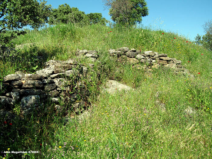
Gruta do Escoural submitted by Magalhaes on 30th Apr 2006. Wall from the neolithic (?) settling, straight uphill from the cave.
(View photo, vote or add a comment)
Log Text: Next I go for a quick look at the Escoural caves, which are all fenced off and locked up, with a sign telling how to book a visit with at least 24 hours notice. Hey Ho.
Guinivrit
Trip No.203 Entry No.529 Date Added: 28th May 2020
Site Type: Passage Grave
Country: France (Bretagne:Finistère (29))
Visited: Yes on 21st Jun 2005. My rating: Condition 3 Ambience 4 Access 4

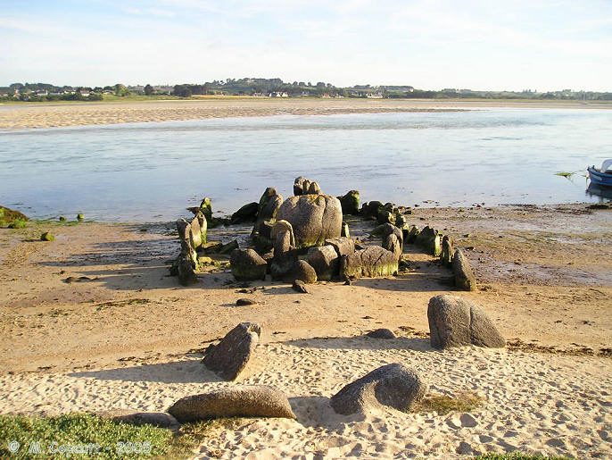
Guinivrit submitted by thecaptain on 25th Mar 2006. Guinivrit allée couverte.
The remains of this allée couverte clearly show the rise in sea level over the past 4000 odd years. Twice a day it gets a wash.
(View photo, vote or add a comment)
Log Text: This really is a nice place to visit, certainly when its quiet and the sun is out. I had hoped to see it with the tide well in tonight, but one thing and another and its now gone 8:00, and the tide is already gone out for two hours, and the water has gone from around it. However, there is still a lot of water flooding out of the bay, and I certainly wouldn't want to try and get a boat in here, as its going at running speed.
The allée couverte is easily found down beside the little harbour, and nowadays is signposted. Its not far at all from the little campsite where I stayed. Despite the fact that it has no capstones, and that some of the large side stones have been broken so it could act as a mole in the water for mooring and protecting boats in the past, it really is surprisingly complete. Most of the stones are still in place, not only of the main chamber, but also the peristalith, which is suitably boat shaped. In fact the whole thing looks rather like a boat pulled up onto the shoreline.
The main chamber is about eleven metres long and 1.5 metres in width, but with the outer stones the full size of the monument is more than double that, perhaps 30 metres by 6 metres. There is both a forward and aft extension to the compartmentalised chamber. Fantastic.
While here, I met a chap out for a bike ride, and we got talking about why I was here and ancient stones. He said he has always lived in the area, and as a boy used to play in the Goazvenn dolmen. He went on to tell me about a large fallen menhir that is almost forgotten, and that nobody ever talks about, and which seems to be in no historical records. He told me how to find it by walking around the coast path, and showed me where it was on my map, fallen onto the rocky shore. I decided that this was one place I had to visit, finding these forgotten stones has much more of a thrill than seeing the well known ones.
Guinivrit
Trip No.214 Entry No.2 Date Added: 28th May 2020
Site Type: Passage Grave
Country: France (Bretagne:Finistère (29))
Visited: Saw from a distance on 16th Apr 2014

Guinivrit submitted by thecaptain on 25th Mar 2006. Guinivrit allée couverte.
The remains of this allée couverte clearly show the rise in sea level over the past 4000 odd years. Twice a day it gets a wash.
(View photo, vote or add a comment)
Log Text: Seen from over the estuary from the south, tide out and on the sandy beach.
Gutter Tor north
Date Added: 18th Sep 2010
Site Type: Cairn
Country: England (Devon)
Visited: Yes on 10th Jun 2008

Gutter Tor north submitted by thecaptain on 10th Jun 2008. Right beside the road at SX574672 are the remains of a fairly large cairn, about 22 metres in diameter.
However, this cairn has been well and truly messed around with, no doubt going to make up the road and the nearby walls. In fact, it is perhaps surprising there is anything left of it at all.
(View photo, vote or add a comment)
Log Text: None
Gwallon Longstone
Date Added: 29th Oct 2019
Site Type: Standing Stone (Menhir)
Country: England (Cornwall)
Visited: Yes on 6th Dec 2014

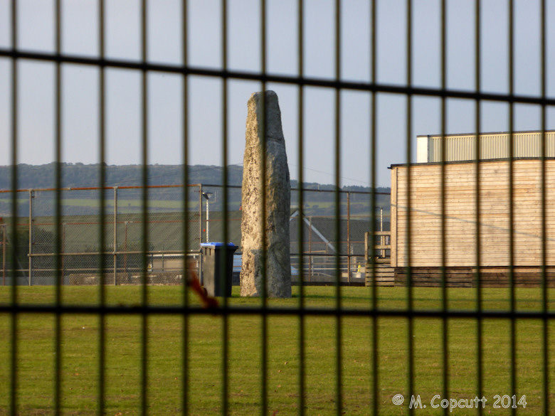
Gwallon Longstone submitted by theCaptain on 6th Dec 2014. It was easy enough to walk along the public footpath surrounding the college grounds on the south side and see the stone from there, but not so simple to get a decent view because of the high fences.
(View photo, vote or add a comment)
Log Text: None
Gweal Hill, Bryher
Date Added: 11th Oct 2020
Site Type: Chambered Tomb
Country: England (Isles of Scilly)
Visited: Yes on 9th Sep 1986

Gweal Hill, Bryher submitted by paulcall on 22nd Oct 2007. This view looks south over the southwestern cairn of the three on Gweal Hill.
The central cist can be seen centre-left, and there are two rings of kerbs both of which can just be seen on this photo, although the whole mound is now greatly weathered by its position on the most westernmost point of the inhabited islands on Scilly.
(View photo, vote or add a comment)
Log Text: During a 2 week sailing trip with friends, we spent the day on Tresco then in the evening I rowed myself over to Bryher to have a look at the place and watch the sun go down from Gweal Hill
Gwernvale
Date Added: 18th Sep 2010
Site Type: Chambered Tomb
Country: Wales (Powys)
Visited: Yes on 9th May 2004

Gwernvale submitted by TheCaptain on 9th May 2004. Gwernvale, Chambered Tomb in Powys, SO211192
Looking into the remaining chamber, from the entrance passage way
(View photo, vote or add a comment)
Log Text: None
Hadleigh Roundhouse
Date Added: 29th Oct 2019
Site Type: Ancient Village or Settlement
Country: England (Essex)
Visited: Yes on 27th Aug 2012
Hadleigh Roundhouse submitted by theCaptain on 27th Aug 2012. Hadleigh Country Park in Essex, has built a replica Iron Age roundhouse to
provide a sheltered working environment forschool groups.
(View photo, vote or add a comment)
Log Text: None
Hadrian's Wall
Date Added: 16th May 2023
Site Type: Misc. Earthwork
Country: England (Northumberland)
Visited: Yes on 23rd Sep 2022. My rating: Condition 4 Ambience 5 Access 4

Hadrian's Wall submitted by johndhunter on 23rd Jun 2019. Hadrian's Wall – Looking East towards Sewingshields Crags, May 2012
(View photo, vote or add a comment)
Log Text: A day exploring Hadrians Wall. Drive to Housesteads, bus to The Sill, then walk up to the trig point on Winshield Crag before walking eastwards along Hadrian's wall back to Housesteads Fort, having lunch at Sycamore Gap.
Hadrian's Wall (Coria)
Date Added: 10th Apr 2023
Site Type: Stone Fort or Dun
Country: England (Northumberland)
Visited: Yes on 26th Sep 2022. My rating: Condition 4 Ambience 4 Access 5

Hadrian's Wall (Coria) submitted by Anne T on 3rd Aug 2019. Some of the granary structures in the north western part of the site.
(View photo, vote or add a comment)
Log Text: Afternoon visit to Corbridge and a look round the tremendous old Roman town remains of Coria. Excellent museum and information centre.
Hadrian's Wall - Milecastle 37
Date Added: 22nd Apr 2023
Site Type: Stone Fort or Dun
Country: England (Northumberland)
Visited: Yes on 23rd Sep 2022. My rating: Condition 4 Ambience 4 Access 3

Hadrian's Wall - Milecastle 37 submitted by TheCaptain on 22nd Apr 2023. Milecastle 37 is one of the best preserved Milecastles along Hadrian’s Wall, immediately to the west of Housesteads Roman Fort. T
(View photo, vote or add a comment)
Log Text: Day on Hadrians Wall. Drive to Housesteads, bus to The Sill, then walk up to the trig point on Winshield Crag before walking back eastwards along Hadrians wall to Housesteads Fort, having lunch at Sycamore Gap. This is a splendid milecastle and place, with a nice almost completely arched gateway north through the wall.
Hadrian's Wall - Milecastle 39
Date Added: 26th Apr 2023
Site Type: Stone Fort or Dun
Country: England (Northumberland)
Visited: Yes on 23rd Sep 2022. My rating: Condition 3 Ambience 4 Access 3

Hadrian's Wall - Milecastle 39 submitted by TheCaptain on 26th Apr 2023. Milecastle 39 on Hadrian’s Wall, immediately to the west of the extremely scenic Sycamore Gap.
(View photo, vote or add a comment)
Log Text: Day on Hadrians Wall. Drive to Housesteads, bus to The Sill, then walk up to the trig point on Winshield Crag before walking back eastwards along Hadrians wall to Housesteads Fort, having lunch at Sycamore Gap. This well presented milecastle is immediately to the west of the extremely scenic Sycamore Gap.
Hague-Dick
Trip No.202 Entry No.27 Date Added: 26th Mar 2020
Site Type: Misc. Earthwork
Country: France (Normandie:Manche (50))
Visited: Yes on 26th Apr 2005. My rating: Condition 3 Ambience 2 Access 5

Hague-Dick submitted by TheCaptain on 9th May 2005. Several square miles at the northwestern tip of the Cherbourg peninsula, was once defended from the rest of the world by a 2 mile long ditch and bank, which connected between two deep valleys to defend the whole area.
Much of this dyke has now been destroyed, but a good section remains to the northwest of the village of Beaumont Hague, where it can be clearly seen as the roads to Digulleville cut through it.
(View photo, vote or add a comment)
Log Text: Cap de la Hague several square miles at the northwestern tip of the Cherbourg peninsula was once defended from the rest of the world by a 2 mile long ditch and bank which connected between two deep valleys to defend the whole area.
Much of this dyke has now been destroyed but a good section remains to the northwest of the village of Beaumont Hague where it can be clearly seen as the roads to Digulleville cut through it. The bank is generally about 4 metres in height but in places it must be nearer 10 metres tall with small ditches on the landward side. Excavations have shown that the bank was first built in the bronze age but much added to and increased during the time of the Viking occupation in the ninth century.
