Contributory members are able to log private notes and comments about each site
Sites theCAptain has logged. View this log as a table or view the most recent logs from everyone
Mas de Labat 1
Trip No.203 Entry No.208 Date Added: 21st Apr 2020
Site Type: Burial Chamber or Dolmen
Country: France (Midi:Lot (46))
Visited: Yes on 31st May 2005. My rating: Condition 2 Ambience 3 Access 3
Mas de Labat 1 submitted by ocdolmen on 30th Jun 2007. photo of Mas de Labat dolmen 1.
This monument has lost its capstone (it is 2 metres far from the burial chamber)
(View photo, vote or add a comment)
Log Text: Once the lane through Mas de Labat has been found this one is fairly easy to find as it is given away by the mound at the top of the hill amongst some scrubland in a field. Having said that it seems to be becoming very overgrown and indeed is not much more than a mound at the top of a hill now. At the centre of the mound a small 2 m by 0.7 m chamber can be seen between two side slabs visible amongst the bush. There was no sign of any capstone.
Mas de Greil Oppidum
Trip No.203 Entry No.147 Date Added: 15th Apr 2020
Site Type: Promontory Fort / Cliff Castle
Country: France (Midi:Lot (46))
Visited: Saw from a distance on 25th May 2005

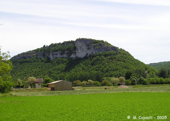
Mas de Greil Oppidum submitted by thecaptain on 21st Jan 2006. High on cliffs overlooking the Célé river, this hill has been inhabited and used as a hilltop refuge since 5000BC.
It doesn’t need much defending but there are 5 metre deep ditches across the neck of land attaching it to the high Causse.
(View photo, vote or add a comment)
Log Text: High on cliffs overlooking the Célé river this hill surrounded on 3 sides by high cliffs has been inhabited and used as a hilltop refuge since 5000BC. It doesn’t need much defending but there are 5 metre deep ditches across the neck of land attaching it to the high Causse.
Mas Cadenet dolmen
Trip No.205 Entry No.204 Date Added: 29th Nov 2020
Site Type: Passage Grave
Country: France (Provence:Bouches-du-Rhône (13))
Visited: Couldn't find on 22nd Sep 2005
Log Text: I could not find this dolmen or hypogae, there are lots of private property signs all around, although not the big fences this time.
Marsigalliet Dolmen 1
Trip No.203 Entry No.200 Date Added: 20th Apr 2020
Site Type: Burial Chamber or Dolmen
Country: France (Midi:Lot (46))
Visited: Yes on 31st May 2005. My rating: Condition 4 Ambience 4 Access 4

Marsigalliet Dolmen 1 submitted by johnstone on 8th Jan 2018. Nice dolmen in the wood, July 1, 2017
(View photo, vote or add a comment)
Log Text: This dolmen is found a couple of kilometres to the northwest of Laramière, along the GR.36 footpath, but which for this stretch is a driveable track. It is then a hundred or so metres walk into the forest, but signposted.
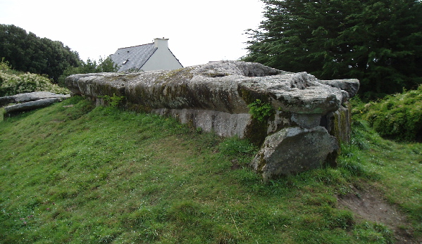
This is another much larger than average dolmen for round here, still mostly contained within its mound. Unfortunately, at some time in the past, the capstone and chamber ends have been broken and incorporated into a wall. The chamber is over 4 metres in length, 2 metres wide and 2 metres high, and faces substantially to the south of east, at 147°. The capstone was probably once nicely shaped, and 3.5 metres wide at the front end. There are other dolmens to be found in the woods around here.
Mardon Down S
Date Added: 28th Sep 2020
Site Type: Stone Circle
Country: England (Devon)
Visited: Yes on 26th Feb 2019. My rating: Condition 3 Ambience 4 Access 3
Mardon Down S submitted by TheCaptain on 25th Mar 2019. View across Mardone Down stone circle. I was slightly surprised to find it so cleared of all the gorse, and easy to find.
Who could believe this was February on Dartmoor !
(View photo, vote or add a comment)
Log Text: Further south along the ridgetop path, and I arrive at a large wide open green area, where I can see the remains of the stone circle extending around the exterior. The first part I get to has another of what looks like a little cairn right on the circumference of the circle, but again the hole in the centre looking too deep and recent. I initially wonder whether I can see the remains of a sort of cist capstone at one place, but which later I wonder whether it is one of the remaining circle stones fallen and buried here. The circle is the largest on Dartmoor at 38 metres diameter and clear to see, but in a very ruinous state, with only 2 or 3 stones still standing of what was probably once between 60 and 70. There is still a nice arc of stones on the southeast side, with one still standing and a large fallen block. Opposite to this on the northwest side is another good arc, with one very interesting shaped large slab still standing, and a couple more a bit further round. I dont get great feelings here, probably as its all pretty much wrecked, and too easy to find. Perhaps it would have been more atmospheric it it was all still hidden and lurking within the gorse. This gorse was still surruounding the whole circle, preventing seeing any of the fabulous views available from elsewhere on the hill.
Mardon Down Ring Cairn
Date Added: 28th Sep 2020
Site Type: Ring Cairn
Country: England (Devon)
Visited: Yes on 26th Feb 2019. My rating: Condition 2 Ambience 3 Access 3
Mardon Down Ring Cairn submitted by TheCaptain on 6th Mar 2019. In places there are some semblances of structure.
(View photo, vote or add a comment)
Log Text: A bit further south along the ridgetop pathway is a large open green area to the west, with the fairly clear remains of a large 20m diameter ring cairn, looking much like a saucer. Much of this cairn has been ruined, but in places there are some semblances of structure. On the eastern side of the pathway here is another recently cleared area which looks to have a cairn located within it, a circular pile of stones with a deep hole in the middle, surrounded by a bank of earth and stones, which all looks too recent and certainly not prehistoric, unless it has perhaps been recently excavated and left without backfilling. I wondered whether it was perhaps a shooting hide, but learned later that it was a mortar pit, made by troops based here in the build up to D Day during the second world war.
Mardon Down N
Date Added: 28th Sep 2020
Site Type: Stone Circle
Country: England (Devon)
Visited: Yes on 26th Feb 2019. My rating: Condition 3 Ambience 5 Access 4
Mardon Down N submitted by TheCaptain on 16th May 2019. Febrary 2019: Approaching from the hilltop ridge path down to the northern circle, and the standing pillars of it make a splendid sight against the distant fields and forests.
(View photo, vote or add a comment)
Log Text: Approaching from the hilltop ridge path down to the northern circle, and the standing pillars of it make a splendid sight against the distant fields and forests. I am not sure what to make of it, is it a stone circle, a cairn with a surrouding circle of stones, or perhaps even a large roundhouse with large pillars incorporated ? There seems to be a double faced ring of edge set slabs, with half a dozen upright pillars incorporated. Now I am home and reading my Butler, it seems he is not sure what to make of it either, stating "it is unparalelled among the numerous cairns on the moorland massif only a short distance to the west, emphasizing the very localised nature of some cairn designs." Whatever it is, its a nice thing to visit, and i sit here listening to the skylarks and buzzards for a while before heading back down to a sandwich at the car and decide what to do next.
Mardon Down Cairn 3
Date Added: 28th Sep 2020
Site Type: Cairn
Country: England (Devon)
Visited: Yes on 26th Feb 2019. My rating: Condition 2 Ambience 3 Access 3
Mardon Down Cairn 3 submitted by TheCaptain on 6th Mar 2019. Just south of the Giant's Grave is a smaller, but much clearer cairn, about 10m diameter and still with some semblance of a retaining circle of stones.
(View photo, vote or add a comment)
Log Text: Just south of the Giant's Grave is a smaller, but much more clear to see cairn, about 10m diameter and still with some semblance of a retaining circle of stones.
Mardon Down Cairn 1
Date Added: 28th Sep 2020
Site Type: Cairn
Country: England (Devon)
Visited: Yes on 26th Feb 2019. My rating: Condition 3 Ambience 4 Access 3
Mardon Down Cairn 1 submitted by TheCaptain on 5th Apr 2019. Just south of the circle is what at first looks like a pile of large stones, but upon investigation is the remains of a cairn with much of the remains of a circle of surrounding stones, with four large blocks at its southern side, and a large slab just on the outside, probably once the capstone to an internal cist.
(View photo, vote or add a comment)
Log Text: Just south of the circle is what at first looks like a pile of large stones, but upon investigation is the remains of a cairn with much of the remains of a circle of surrounding stones, and with four large blocks at its southern side, and a large slab just on the outside, probably once the capstone to an internal cist. This is a nice monument. I continue on southwards to get a look at the wonderful views from the edge of the hill all the way round from the east through the deep valleys to the south and out to the west with the heights of the main bulk of Dartmoor. There are a lot of fires out there today, I suspect from burning off of the gorse and bracken.
Marden Henge
Date Added: 8th Oct 2020
Site Type: Henge
Country: England (Wiltshire)
Visited: Yes on 18th Jul 2002. My rating: Condition 2 Ambience 3 Access 5

Marden Henge submitted by Jansold on 24th Jul 2015. View of excavations during summer 2015.
Marden Henge is the biggest henge in England but because it did not have a stone circle associated with it, has tended to be overlooked. A huge mound, like a smaller version of Silbury Hill, named Hatfield Barrow, once existed within the henge, but it was levelled in the 19th C.
Foundations have been excavated within the henge that could have been a Neolithic sauna, containing a sunken hearth that would have given out intense heat.
(View photo, vote or add a comment)
Log Text: None
Marden Down East
Date Added: 28th Sep 2020
Site Type: Ring Cairn
Country: England (Devon)
Visited: Yes on 26th Feb 2019. My rating: Condition 3 Ambience 3 Access 4

Marden Down East submitted by TheCaptain on 4th Mar 2019. Heading up to the top of Mardon Hill from the Headless Cross, and about halfway up there is a recently cleared area by the path, with the clear remains of a ring cairn, which I was not expecting to see from my quick look in Butler before heading off for the day.
(View photo, vote or add a comment)
Log Text: Heading southwest up to the top of Mardon Hill, and about halfway up there is a recently cleared area by the path, with the clear remains of a ring cairn which I was not expecting to see from my quick look in Butler before heading off for the day, which basically states that there are probably other cairns on the down, but the whole hill is overgrown with gorse and bracken making everything hard to find! This pattern held for the rest of my visit, as the local commoners have taken it upon themselves to hunt down and clear the large amount of archaeology there is to be found here, from cairns and the stone circle, through reaves, right through to mortar pits, trenches and even railway making exercises carried out by the American soldiers based here before the D-Day invasions.
Marchain Dolmen
Trip No.205 Entry No.20 Date Added: 14th Oct 2020
Site Type: Burial Chamber or Dolmen
Country: France (Poitou:Vienne (86))
Visited: Yes on 31st Aug 2005. My rating: Condition 3 Ambience 3 Access 2

Marchain dolmen submitted by thecaptain on 11th Feb 2006. To the west of the village of Lathus-Saint-Rémy, in the fields near to the hamlet of Marchain, can be found this dolmen. It can be seen across the fields by the crossroads to the south of the hamlet, but I could find no obvious way to get to the dolmen, all the fields being fenced off.
(View photo, vote or add a comment)
Log Text: To the west of the village of Lathus-Saint-Rémy, in the fields near to the hamlet of Marchain, can be found this dolmen. It can be seen across the fields by the crossroads to the south of the hamlet, but I could find no obvious way to get to the dolmen, all the fields being fenced off. It looks to be a fairly simple little dolmen, with a capstone set on top of a few support stones.
Manémeur 2 & 3 menhirs
Trip No.203 Entry No.424 Date Added: 21st May 2020
Site Type: Standing Stones
Country: France (Bretagne:Morbihan (56))
Visited: Yes on 14th Jun 2005. My rating: Condition 4 Ambience 4

Manémeur 2 & 3 menhirs submitted by thecaptain on 7th Jun 2006. These are a nice pair good sized menhirs just inland from the Cote Sauvage, up a slight rise towards the hamlet of Manémeur.
The two of them are about 20 metres apart, the bigger one being about 5 metres high, its companion 3 metres.
(View photo, vote or add a comment)
Log Text: These are two good sized menhirs just inland from the Cote Sauvage, up a slight rise. The two of them are about 20 metres apart, the bigger one being higher up the slope. It is about 5 metres high, 3 metres wide and tapers upwards. Its smaller companion is about 3 metres high. Both have some lovely lichen growing on them.
Manémeur 1 menhir
Trip No.203 Entry No.423 Date Added: 21st May 2020
Site Type: Standing Stone (Menhir)
Country: France (Bretagne:Morbihan (56))
Visited: Yes on 14th Jun 2005. My rating: Condition 3 Ambience 3 Access 5

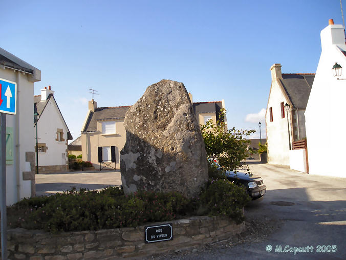
Manémeur 1 menhir submitted by thecaptain on 6th Jun 2006. This menhir is right in the central square of the hamlet of Manémeur. It is about 3 metres high, 2 m wide and 0.5 m thick, and has several cupules in its southern face.
(View photo, vote or add a comment)
Log Text: This menhir is right in the central square of the hamlet of Manémeur. It is about 3 metres high, 2 m wide and 0.5 m thick, and has several cupules in its southern face. It is nowadays kept within a little circular flowerbed, unfortunately squeezed between roadsigns and parked cars while I was here, making pictures difficult.
Mane-Rethuel Dolmen
Trip No.203 Entry No.353 Date Added: 10th May 2020
Site Type: Burial Chamber or Dolmen
Country: France (Bretagne:Morbihan (56))
Visited: Yes on 11th Jun 2005. My rating: Condition 4 Ambience 4 Access 4

Mane-Rethuel dolmen submitted by AlexHunger on 21st Sep 2004. Dolmen de Mane-Rithual in central Locmariaquer viewed from North. Entrance is at oposite end.
(View photo, vote or add a comment)
Log Text: I thought I had seen some pretty impressive megalithic constructions before, but the Locmariaquer ones are making me think again. This is a massively long passage grave, built in at least two different ages. The first stage is a 3 metre by 2 metre oval chamber at the end of a 10 metre passage opening at a bearing of 108°. At least one large ex menhir is used in the capstones of this passage.
Then at a later stage, a second 4 m by 3 m oval chamber was added at the back end, using part of a massive broken menhir, 11 metres in length, from near the Grande Menhir Brise as its capstone. This stone has a 6 metre long carving on its underside which gives evidence of its previous usage. Inside the first chamber are carvingss of axes, ploughs etc, and a stele, probably also moved here from elsewhere. Whoever built this monument must have employed a right bunch of cowboy builders, although their construction has stood the ravages of time well.
Mané-Kerioned Dolmen
Trip No.203 Entry No.392 Date Added: 14th May 2020
Site Type: Burial Chamber or Dolmen
Country: France (Bretagne:Morbihan (56))
Visited: Yes on 13th Jun 2005. My rating: Condition 5 Ambience 3 Access 5

Mané-Kerioned dolmen submitted by JJ on 9th Nov 2002. Mané-Kerioned dolmen
(View photo, vote or add a comment)
Log Text: This monument is in the process of being cleared of undergrowth at the time of my visit, so despite cutting and strimmers working around the place, I will get to see it. Perhaps the authorities are just starting on a major clear up of many of the ancient sites after years of neglect.
Much has been written about this place and the finds excavated here in the past, so I will not write much. This site has a collection of three passage graves, once all contained within a large oval mound, some of which still remains despite the road cutting right through it. Two of the passages are aligned north south, with the entrances at the south, while the other is situated between these, and aligned east west with its opening to the east.
The central and western chambers are now largely fully above ground, but the eastern chamber is almost completely still below ground level in what remains of the mound. Entry to this passage is down some modern stairs, and a torch is necessary to see the insides properly. Within this tomb, there are many finely carved stones, with unusual chequerboard designs on them, as well as some more standard serpents and axes, but unfortunately my camera seemed to be playing up again.
At various places surrounding the site are several menhirs remaining.
Mané-Groh Dolmen
Trip No.203 Entry No.398 Date Added: 14th May 2020
Site Type: Burial Chamber or Dolmen
Country: France (Bretagne:Morbihan (56))
Visited: Yes on 13th Jun 2005. My rating: Condition 5 Ambience 4 Access 5

Mané-Groh dolmen submitted by JJ on 9th Nov 2002. Mané-Groh dolmen
(View photo, vote or add a comment)
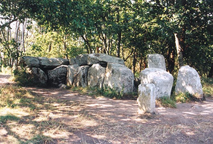
Log Text: Now this is more like it. Signposted and kept tidy in a pleasant forest glade with a nearby carpark, this tomb is found a few hundred metres to the northeast of Crucuno village. It is a large transepted dolmen with a central entry corridor 7 metres long, and two pairs of side chambers, each being about 1.5 metres by 2 metres, at the rear, western end. Each of the side chambers, and the entry passageway is covered, but unfortunately the large capstones over the main chamber between the sides have gone. It is still on the remains of quite a substantial mound, and has been built on top of an earlier, smaller chamber, another of which can be seen just 20 metres further behind the big dolmen.
This is right at the start point for a signposted "Megalithic walk" so I have decided that I will now follow this trackway on my bike. My first notebook is now full up, and my camera memory card also. Thankfully I was expecting this to happen, and have both another notebook and picture card with me in my bag. Signing off from book 1, and its over to book 2, which is unfortunately not in a ring binding form.
Mané-er-Hroëck tumulus
Trip No.203 Entry No.354 Date Added: 10th May 2020
Site Type: Chambered Tomb
Country: France (Bretagne:Morbihan (56))
Visited: Yes on 11th Jun 2005. My rating: Condition 4 Ambience 4 Access 4

Mané-er-Hroëck tumulus submitted by greywether on 30th Jun 2005. The modern entrance to this underground chamber.
(View photo, vote or add a comment)
Log Text: Blimey, whatever next ? This is a large mound of stones, just to the south of the village of Locmariaquer. A path leads up between the houses to the top of the tumulus, of which the shape and size are indeterminate due to the houses all around it. Once on top of the tumulus, a set of relatively modern steps cut downwards into the heart of the mound through the stones. Down it goes, round a corner, and then, 10 metres in and 5 metres down, there is an entrance into a chamber.
It is a simple chamber, about 5 metres by 3 metres, but not quite high enough to stand up straight in. The walls are largely drystone, with a couple of large capstones forming the roof. I could not make out if there were any carvings, but it was dark and my lamp was fairly feeble. This is another fantastic find, and again passed by and missed by the masses. Take a good torch.
Mané-Brizil Dolmen
Trip No.203 Entry No.374 Date Added: 11th May 2020
Site Type: Burial Chamber or Dolmen
Country: France (Bretagne:Morbihan (56))
Visited: Saw from a distance on 12th Jun 2005

Mané-Brizil dolmen submitted by binardino on 14th Jun 2006. Mané-Brizil dolmen
(View photo, vote or add a comment)
Log Text: This dolmen is now within private property, but a few stones of what is possibly the dolmen with couloir can be seen inside the entrance of a large chateau like place, up the driveway entrance.
Mané Roullarde
Trip No.203 Entry No.365 Date Added: 11th May 2020
Site Type: Burial Chamber or Dolmen
Country: France (Bretagne:Morbihan (56))
Visited: Yes on 12th Jun 2005. My rating: Condition 2 Ambience 3 Access 4

Mané Roullarde submitted by TheCaptain on 10th Nov 2007. The informative multilingual signboard.
(View photo, vote or add a comment)
Log Text: The remains of this monument are to be found on a hilltop site overlooking the yachting and seaside town of La Trinité-sur-Mer, now surrounded by expensive looking flats. There is an 18 metre long Allée Couverte known as Er-Groh, with only 4 capstones remaining in place, which faces southeast at 150°. Some of the side support stones have Pierres-Plates style engravings on them, but being exposed in this external situation, they are very difficult to make out amongst the lichens and moss etc.
At some point in the past it has had a wall built into it. There are also said to be several underground passages to be found here, which date back to Gallic iron age times, and of which the description reminds me of the Cornish Fougous. However, I found it impossible to find any of these to be seen amongst the undergrowth of the area.
